Location: East Bohemia Map
Area: 17 km²
Adršpach-Teplice Rocks (Czech: Adršpašsko-teplické skály, German:
Adersbach-Weckelsdorfer Felsenstadt) form one of the most
spectacular and largest sandstone “rock cities” in Central Europe.
This national nature reserve sprawls across 17.12 km² in the Hradec
Králové Region of northeastern Bohemia, Czech Republic, near the
Polish border. It lies in a triangle bounded by the villages of
Adršpach, Teplice nad Metují, and Čáp Peak (above Skály), within the
broader Broumovsko Protected Landscape Area.
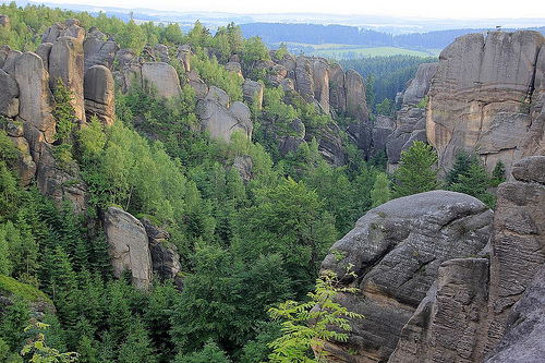
The site comprises
two adjacent but distinct rock labyrinths — the Adršpach Rocks
(Adršpašské skály) and the Teplice Rocks (Teplické skály) —
separated by the dramatic Vlčí rokle (Wolf Gorge). Towering
sandstone pillars, narrow gorges, natural arches, and bizarrely
shaped formations create a fairy-tale landscape that feels
otherworldly.
Location and Extent
The reserve lies in the Hradec Králové Region
of eastern Bohemia, Czech Republic, within the Broumovsko Protected
Landscape Area (CHKO Broumovsko) and the Kladské pomezí tourist region.
It occupies the districts of Náchod and Trutnov and sits roughly in a
triangle bounded by the villages of Adršpach (specifically Horní
Adršpach), Teplice nad Metují, and the peak of Čáp (above the village of
Skály).
Geographic coordinates center around 50°36′41″N 16°06′54″E.
The protected area covers 17.12 km² (6.61 sq mi) and spans elevations
from approximately 480 m at the northeastern foothills to 786 m at the
summit of Čáp.
Geology and Formation
The bedrock consists of
Upper Cretaceous quartzose (blocky/tabular) sandstones deposited on the
floor of the ancient Cretaceous sea. After the sea retreated, tectonic
uplift combined with prolonged erosion, weathering, and denudation (by
water, wind, frost, and chemical processes) dissected a once-continuous
sandstone plateau. Water widened vertical joints and bedding planes,
while selective weathering isolated towers, walls, and labyrinths.
This process occurred over tens of millions of years within the broader
Elbe Sandstone Mountains geological province (extending into Poland and
Germany). The rocks form part of the Broumovská vrchovina (Broumov
Uplands) and specifically the Teplické pánve subunit. The silica-rich
substrate produces thin, nutrient-poor soils that support specialized
vegetation (heather, blueberries, cranberries).
Topography and
Geomorphology
The reserve comprises two distinct rock cities linked
by a continuous plateau but dramatically separated by the Vlčí rokle
(Wolf Gorge or Wolf Canyon), a 7 km-long deep canyon. Thousands of rock
towers, pillars, cliffs, boulders, and labyrinthine passages create a
maze-like landscape up to ~100 m high in places.
Adršpašské skály
(Adršpach Rocks):
Dense clusters of towers dominate, with some
reaching 90 m (the tallest named formation, “Milenci” or The Lovers,
stands at 81.4 m). Features include narrow alleys (as slim as 50 cm),
deep gorges, and a prominent 16 m-high Great Waterfall. The area also
contains picturesque crystal-clear lakes/ponds (including a flooded
sandpit area). A fee-based circular trail (often marked yellow) winds
through this section.
Teplické skály (Teplice Rocks):
More
extensive rock walls and intricate plateau labyrinths (notably the
Bludiště area) characterize this section. Key ridges include Skalský
hřeben (highest point Skály at 694 m), Čáp (786 m), Supích skal (771 m),
and Kraví hory (734 m). About 70 named formations exist here, traversed
by the Skalní potok stream. A fee-based circular trail follows the
stream; outer areas (Supích skal, Čáp) are free to access.
Hydrology
Water plays a central role in both formation and current
landscape. The Vlčí rokle canyon marks the source of the Metuje River.
The Teplické section follows the course of the Skalní potok stream. The
Great Waterfall (16 m) cascades over sandstone in the Adršpach area.
Porous sandstone allows deep infiltration, creating talus caves —
including the Teplická jeskyně, the longest in the Czech Republic at
1,065 m — with features like root stalagmites.
Climate and
Environment
The upland location produces a temperate continental
climate with higher precipitation and cooler temperatures than
surrounding lowlands. Dense forests (mainly spruce and pine) cloak the
plateau, while vertical rock faces host specialized flora and provide
nesting sites for peregrine falcons (one of Europe’s largest permanent
breeding populations). Certain zones remain off-limits to protect
wildlife.
Protection and Significance
Declared a national
nature reserve (Národní přírodní rezervace) on 31 December 1933 (IUCN
Category Ia — strict nature reserve), it has been managed by the Agency
for Nature Conservation and Landscape Protection of the Czech Republic
(AOPK ČR) since 2015. It forms a core part of the Broumovsko Protected
Landscape Area (since 1991). Rules prohibit climbing in sensitive zones,
fires, smoking, biking, and plant picking to preserve the fragile
ecosystem.
The Adršpach-Teplice Rocks exemplify classic sandstone
geomorphology and rank among the Czech Republic’s premier natural
landmarks and rock-climbing destinations.
Adršpach Rocks: The Iconic “City of Rocks”
This is the more
popular section, with a 3.5 km green-marked circuit (allow 3+ hours). It
includes the largest rock labyrinth in the Czech Republic, narrow
alleys, and engineered features from the 19th century.
Key
landmarks:
Gothic Gate — Built in 1839 by Count Ludvík Karel Nádherný
as the grand entrance. This stone archway with iron gates sits in a
dramatic narrow slot canyon between towering walls, leading into the
heart of the labyrinth. It symbolizes the entire reserve.
The Lovers
(Milenci) — The tallest formation at 81.4 m. This iconic pair of towers
resembles embracing figures and offers one of the most photographed
views from multiple viewpoints. It was first climbed in 1923.
Mayor
and Mayoress (Starosta a Starostová), Štěpánek’s Crown, and Small &
Large Aldermen — These anthropomorphic groups of towers and crowns are
best seen from elevated viewpoints near the Great Waterfall and
Starozámecký Hill.
Sugar Loaf (Cukrová homole) — A bizarre inverted
tower (wide top, narrow 3 m base) that looks like an upside-down cone or
tenpin. Early tourists wedged sticks at its base to “stabilize” it.
The Jug (Džbán) — A massive tower with a natural six-metre “window”
forming a handle-like opening, evoking a giant jug or dolphin.
Great
Waterfall (Velký vodopád) — A regulated 16 m cascade tumbling down a
rocky gorge. Water flows from an upstream reservoir (used for historic
lumber transport and now scenic boat rides). The echo here is
legendary—shots or shouts rebound up to seven times. A bronze bust of
Goethe (who visited in 1790) stands nearby.
Pískovna Lake (Crystal
Sand Quarry Lake) — A stunning turquoise, crystal-clear flooded quarry
(3 ha, up to 12.5 m deep) created in the 20th century. A peaceful path
encircles it, offering reflections of the surrounding cliffs.
Crystal
clear water at sand quarry pond. Clay quarry, muddy shore surrounded by
trees outdoors Stock Photo - Alamy
The Mouse Hole — The narrowest
passage (only 50 cm wide).
The King (Král) — The first tower climbed
(1923), part of early mountaineering history that also includes the
Battlements, Saxon Head, Martin’s Crown, and Eagle.
Additional
highlights include the Starozámecký Hill viewpoint (with ruins of
Adršpach Castle) and panoramic trails like the “Under Cross Hill” nature
path.
Teplice Rocks: Wilder and More Extensive
This larger
section requires at least 3–4 hours on a 6 km blue-marked circuit with a
dedicated nature trail (15 information stops on geology, history, flora,
fauna, and climbing, opened in 1999 and dedicated to environmentalist
Josef Vavroušek). It feels more rugged and less crowded.
Key
landmarks:
Stone Crown (Skalní koruna or Rock Crown) — The majestic
symbol of Teplice Rocks. This towering formation looks regal from every
angle and was first climbed in 1927. Nearby is the Giant Garden and the
Temple (a huge cavern once used for barrel-organ concerts, reached by
stairs).
Střmen Castle Ruins — Perched dramatically on a rock
pinnacle. Climb metal ladders and stairs for breathtaking panoramic
views over the forest and distant hills. This is a highlight for
adventurers.
Guard Tower — One of the most recognizable tall, smooth
pillars and a symbol of the area.
Golem, Butcher’s Axe (Řeznická
sekera), Caterpillar (Housenka), Polar Bear (Lední medvěd), Sphinx,
Herring (Sleď), Giant’s Toothpick, and Huckleberry Hound — Dozens of
whimsically named formations that spark the imagination as you hike.
Siberia — A chilly microclimate where snow lingers into summer.
Other
features: Martin’s Walls, Rock Temple, Lion’s Cage, Krakonoš’ Garden,
the Echo point (mortar shots for tourists), and the Cabin of the Rock
Bride viewpoint overlooking the Hláska rock crack.
The entire
area features rich biodiversity, moss-covered walls, and towering pines
clinging to ledges.
Practical Visitor Information & Tips
Access: Separate entrances (Adršpach near the village; Teplice near
Teplice nad Metují). You can combine both in one day via connecting
trails, but allow 6–8 hours total.
Tickets & Parking: Buy online in
advance (limited daily capacity) to skip queues. Parking is
limited—reserve spots online.
Rules: Stay on marked paths; no drones,
fires, bikes, or off-trail wandering. Dogs must be leashed. The terrain
involves stairs, ladders (in Teplice), and uneven paths—wear sturdy
shoes.
Best time: Spring/autumn for fewer crowds and beautiful
foliage; winter transforms the waterfall into an icefall.
Nearby:
Broumov Monastery, Ostaš Rock, or Polish border crossings for extended
hikes.
The Adršpašsko-Teplice rocks, with their hundreds of isolated and
bizarre rock towers, are a popular climbing terrain. Climbing here has a
long and colorful history. The first ascents in Adršpach were made
already in 1923 by members of the German club K.V. Lössnitz, who with
the equipment of the time were able to climb some dominant rock towers
(Král, Cimbuří, Saská Hlava, Martinská Koruna, Milenci, Starostová or
Orel). Skalní koruna (1927) was the first tower conquered in Teplické
skály. The pre-war ascents were, with honorable exceptions (Czech
Alpinists' Club 1935), a matter for Saxons and, gradually, local Germans
as well. In the post-war period, the era of Czechoslovak first ascents
also begins, continuing through generational changes (and from 1960,
once again the excellent Saxon "competition") essentially to the present
day. A peculiar climbing (climbing) subculture is also intrinsically
connected to the area, maintaining the "sandwich" tradition and
congregating mostly in local "refreshments". Those interested in the
history of climbing here can recommend the book Píškaři.
Smooth
slabs, joints and chimneys of various widths are characteristic of local
rock climbing. "Classic" ascents often require mental toughness (the
ability to handle fear) and belay skills. Thanks to the sporting
tradition and rules prohibiting, among other things, adding new belays,
even today's climbers can compare their abilities with previous
generations of pioneers and first ascents.
Since 1992, the Czech
Mountaineering Association, on behalf of all mountaineers, has had to
negotiate an exemption from the law banning mountaineering in all our
national nature reserves in order to practice rock climbing in the NPR
Adršpašsko-teplické skály.