Location: Northern Bohemia Map
Transportation:
car 1.5 hours 100 km from Prague
Telephone: 481366255, 481366256
Fax: 481366256
Area: 181 km²
Český ráj (Bohemian Paradise) is a stunning natural and cultural
region in northeastern Czechia (Czech Republic), about 60–90 km
northeast of Prague. It spans parts of the Central Bohemian, Hradec
Králové, and Liberec regions, centered around towns like Jičín,
Turnov, and Mnichovo Hradiště.
The name "Bohemian Paradise" (from
the Czech Český ráj) reflects its romantic, fairy-tale-like beauty,
celebrated since the 19th century by artists, writers, and visitors
drawn to its sandstone rock formations, dense forests, valleys,
castles, and folk architecture. It became the country's first
Protected Landscape Area (CHKO) in 1955 and a UNESCO Global Geopark
in 2015 (the only one in Czechia).
The protected landscape area is 181.5 km² in size. The area belongs
to mainly small rural communities in parts of the Semily, Mladá Boleslav
and Jičín districts. However, there is no exact border for the region.
In essays, books and songs, towns such as Mladá Boleslav, Bezděz, Český
Dub and Sychrov in the west, Bozkov in the north, Nová Paka and
Konecchlumí in the east and Kopidlno, Staré Hrady and Libáň in the south
are included in the region.
The protected area consists of three
separate parts. The geopark, which was declared in 2005, connects them
and also includes the surrounding, non-protected landscape. It extends
to 700 km². The Český ráj tourist region also includes the surrounding
area with 126 municipalities and a total area of 1091 km². In the
east, the region borders on the foothills of the Giant Mountains, in the
north the hilly landscape merges into the Jizera Mountains. To the west
are the wooded areas of the Ralská Pahorkatina. The landscape in the
south, which belongs to the Bohemian Pan, is flat and agricultural.
Geological Origins (Cretaceous Period to Present)
The landscape's
foundation dates back roughly 100 million years to the Cretaceous
period, when much of what is now Central Europe was inundated by a
shallow sea (part of the Bohemian Cretaceous Basin). Sediments—primarily
quartz-rich sands from eroding highlands—were deposited in deltas and
shallow marine environments.
Key layers formed around 94–87 million
years ago, including a remarkably homogeneous, hard quartz sandstone up
to 140 meters thick. This "clean" sandstone, shaped by tectonic
activity, sea level changes, and the Cretaceous Thermal Maximum (a
super-greenhouse phase), forms the basis of today's iconic features.
After the sea retreated around 66 million years ago (end-Cretaceous
extinction), uplift, faulting (especially along the Lusatian fault), and
erosion sculpted the plateau. Over the last 2 million years, rivers
(notably the Jizera and its tributaries), wind, rain, and especially
freeze-thaw cycles during ice ages carved dramatic "rock cities" (skalní
města), pillars (up to 60m high), labyrinths, arches, and gorges.
Volcanic activity added basalt plugs (e.g., at Kozákov and Trosky).
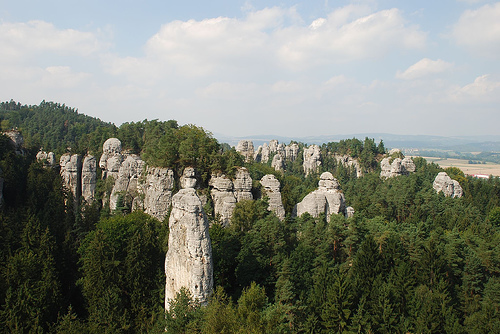
Today, the region features about a dozen main rock cities (e.g.,
Prachovské skály, Hruboskalské skalní město, Suché skály/"The Organ,"
Besedické skály, Drábovna). Prachovské skály has been protected since
1933.
Prehistoric and Early Settlement
Humans have inhabited
the area for at least 10,000 years, with evidence of Stone Age
settlements, especially near rock shelters and caves along the Jizera
River (e.g., Drábovna). The dramatic rock formations likely served as
shelters and lookouts for hunter-gatherers.
By the medieval period,
the area was settled more permanently, with agriculture in valleys and
use of local sandstone for building. Precious stones (garnets, etc.)
from Kozákov volcano supported early gem trade, especially around Turnov
("heart of Bohemian Paradise").
Medieval Period: Castles and
Fortifications
The region's strategic location along trade routes and
its defensible rock outcrops led to numerous castles and strongholds
from the 13th–14th centuries onward. Many were built directly into or
atop sandstone formations.
Valdštejn Castle — One of the oldest,
founded in the 13th century by the Valdštejn (Wallenstein) family
ancestors.
Trosky Castle (late 14th century) — Iconic twin-towered
ruins on basalt plugs; a symbol of the region. It played roles in the
Hussite Wars (15th century) and was damaged in the Thirty Years' War.
Kost Castle (14th century) — Well-preserved, known for its Gothic
architecture.
Hrubá Skála — Mansion/castle complex rebuilt multiple
times, now a hotel/spa.
Others: Frýdštejn, Vranov (rock castle),
Humprecht, Sychrov, Hrubý Rohozec.
The Hussite Wars (early 15th
century) saw fortifications expanded for control of routes. Later
conflicts, including the Thirty Years' War, led to many ruins.
Early Modern to 19th Century: Romanticism and Tourism
In the 17th
century, the rock labyrinths (e.g., Besedické skály) sheltered religious
exiles, who left inscriptions.
The 19th century brought Romanticism,
which popularized the area. Visitors, including artists and nobility,
praised its "paradise" qualities. Spa development (e.g., Sedmihorky) and
improved access boosted early tourism. The Rohan family influenced
estates like Hrubá Skála.
Gem-working in Turnov and folk architecture
(timbered houses) flourished.
20th Century to Present: Protection
and Modern Recognition
1930s: Specific rock areas (e.g., Prachovské
skály) gained protection.
1955: The Protected Landscape Area was
established (initially 95 km², expanded to 181 km² in 2002) as
Czechoslovakia's first—emphasizing biodiversity, geology, and cultural
heritage.
2005: Joined the European Geoparks Network.
2015:
Designated UNESCO Global Geopark (broader area ~830–833 km²).
The
region has appeared in films, TV (e.g., fairy tales, international
productions), and literature. It attracts hikers, climbers, cyclists,
and geotourists, with over 2 million visitors annually in recent years.
Challenges include managing overtourism in peak seasons.
Cultural
and Natural Significance Today
Český ráj blends dramatic geology with
human history: medieval ruins overlooking rock cities, ponds and valleys
(e.g., Podtrosecká údolí), dolomite caves (Bozkov), and biodiversity
(forests, peregrine falcons, etc.). It remains a beloved destination for
its accessibility from Prague and mix of adventure, history, and
tranquility.
Location and Size
The protected landscape area (CHKO Český ráj)
covers 181.17 km² (about 70 sq mi) and was designated in 1955 as the
first protected landscape area in the country. The broader UNESCO Global
Geopark extends to around 830–833 km².
It lies approximately 60–90 km
northeast of Prague in North Bohemia, spanning parts of the Central
Bohemian, Hradec Králové, and Liberec regions. Key towns include Jičín,
Turnov, Mnichovo Hradiště, Železný Brod, and Sobotka. The main river is
the Jizera (with tributaries like the Klenice, Libuňka, and Žehrovka).
Geomorphologically, it lies mostly in the Jičín Uplands, with the
northern part extending into the Ještěd–Kozákov Ridge. Elevations range
from a low of 233 m to a high of 744 m at Kozákov hill.
Geology
and Rock Formations
The landscape's defining feature is its
Cretaceous sandstone "rock cities" (skalní města), formed from sediments
deposited in a shallow Cretaceous sea around 100–87 million years ago.
These sandstones (Cenomanian to Coniacian) reach thicknesses of up to
240 m in places and were laid down in a basin between ancient
landmasses.
Key geological timeline:
~100–94 million years
ago: Shallow tropical sea inundates the area; coarse sands deposited
near shore.
~90–87 million years ago: Cleaner, homogeneous quartz
sandstone layers (up to 140 m thick) form the basis of the rock cities,
influenced by river deltas during a thermal maximum.
Post-Cretaceous:
Uplift, faulting (along the Lusatian fault), and erosion by rivers,
wind, frost, and ice (especially during Pleistocene glaciations) sculpt
the plateau into towers, pillars, cliffs, canyons, and labyrinths.
Tertiary volcanism (roughly 30–5 million years ago) added basalt
intrusions and plugs, visible at sites like Trosky (twin basalt peaks)
and Kozákov. These hardened surrounding rocks and created distinctive
features.
Famous rock areas include:
Prachovské skály (Prachov
Rocks): Iconic towers and labyrinths northwest of Jičín.
Hruboskalsko
(Hrubá Skála): Hundreds of towers and formations, with a castle perched
on rocks.
Příhrazské skály, Suché skály (serrated ridge), Klokočské
skály, and others—totaling around a dozen major "rock cities."
These formations feature pillars up to 50–60+ m high, narrow gorges,
arches, caves, and bizarre eroded shapes (some resembling animals or
objects).
Topography and Hydrology
The terrain is a dissected
sandstone plateau with rolling hills, deep valleys, canyons,
escarpments, and floodplains. Dense forests alternate with meadows,
wetlands, ponds, and streams. The Jizera River and tributaries have
carved dramatic gorges. Volcanic remnants add conical hills and basalt
outcrops.
The varied relief supports microclimates and diverse
habitats.
Climate
The area has a temperate, mildly humid
climate with mild winters. Average annual temperatures are around 7–8°C,
with precipitation of 550–650 mm (up to 700 mm in higher areas). Summers
are moderate (low-to-mid 20s°C), with frequent rain. It feels
storybook-like with misty forests and seasonal changes.
Ecology
and Landscape Character
Forests (pine, mixed), meadows, and wetlands
dominate, supporting wildlife like deer, wild boar, foxes, and birds
(including peregrine falcons). The sandstone provides nesting sites and
unique microhabitats. Many towns use local sandstone in construction,
blending human elements with nature.
The combination of rock cities,
castles (e.g., Trosky ruins dramatically atop volcanic plugs), chateaus,
and forests creates a fairy-tale atmosphere that has inspired artists
and filmmakers.
Flora
The vegetation reflects a mix of forest, meadow, wetland,
and rocky/xerothermic communities. A substantial portion is forested,
with over 1,000 species of vascular plants recorded in the broader
region, including around 45 rare or endangered ones. Many plants are
adapted to nutrient-poor, sandy, or rocky substrates, with influences
from both lowland/thermophilic and montane species via river corridors.
Key forest types:
Pine-dominated forests (Pinus sylvestris) on
rocky outcrops, plateaus, and sandstone "rock cities" (e.g., Prachov
Rocks, Hrubá Skála). These are often relict or acidophilous communities
on thin soils.
Beech forests (Fagus sylvatica), often mixed with
sycamore maple (Acer pseudoplatanus), hornbeam (Carpinus betulus), oak
(Quercus robur or Q. petraea), lime (Tilia platyphyllos), and birch
(Betula pendula). More common in valleys and cooler slopes.
Other
trees: White fir (Abies alba), spruce (in some monocultures), and
scattered deciduous species.
Meadows, grasslands, and open areas:
Flower-rich meadows and thermophilic grasslands host diverse herbaceous
plants. Sunny rocky hillsides support lizards and butterflies alongside
species like Saxifraga decipiens subsp. steinmanii, Vincetoxicum
hirundinaria, Campanula rotundifolia, Digitalis grandiflora, Silene
vulgaris, and ferns such as Polypodium vulgare and Asplenium viride (or
virose) on canyon slopes.
Notable and protected species:
Orchids: Over 20 species, many protected. Examples include Bohemian
marsh orchid (Dactylorhiza bohemica), early marsh orchid (Dactylorhiza
majalis), Fuchs' orchid (D. fuchsii), lady's slipper orchid (Cypripedium
calceolus—critically endangered), and the recently rediscovered
coralroot orchid (Corallorhiza trifida). Wetlands and damp crevices are
key habitats.
Other rarities: Bohemian butterwort (Pinguicula
vulgaris subsp. bohemica), various ferns in humid gorges (e.g.,
Killarney fern Trichomanes speciosum in microclimates), heather (Calluna
vulgaris), and mat grass (Nardus stricta) on exposed rocks.
River
valleys and wetlands support moisture-loving plants like alder (Alnus
glutinosa) carr and aquatic species.
The Jizera River acts as a
corridor allowing montane/piedmont species to descend and thermophilic
plants to spread. Conservation focuses on maintaining habitat diversity
amid tourism and historical land use (the area is a cultural landscape,
not pristine wilderness).
Fauna
The varied habitats—forests,
rocks, wetlands, rivers, caves, and meadows—support diverse wildlife,
including 174 specially protected animal species. Rocky outcrops and
caves are especially important for bats and birds; rivers and wetlands
for amphibians, fish, and aquatic invertebrates.
Mammals:
Common forest species: Roe deer (Capreolus capreolus), wild boar (Sus
scrofa), red fox (Vulpes vulpes), Eurasian red squirrel (Sciurus
vulgaris), wood mouse (Apodemus sylvaticus), European hare (Lepus
europaeus).
Occasional: Mouflon (Ovis musimon), water shrew (Neomys
fodiens).
Bats: Numerous species in caves (e.g., in Apolena rocks or
other sandstone formations), benefiting from rock crevices and
underground sites.
Birds (highly diverse due to nesting sites in
rocks and forests):
Forest birds: Black woodpecker (Dryocopus
martius), goldcrest (Regulus ignicapillus), nuthatch (Sitta europaea),
blackcap (Sylvia atricapilla), wren (Troglodytes troglodytes), dunnock
(Prunella modularis), wood warbler (Phylloscopus sibilatrix), tawny owl
(Strix aluco), wood pigeon (Columba palumbus), spotted flycatcher
(Muscicapa striata).
Rocky/cliff nesters: Common swift (Apus apus),
black redstart (Phoenicurus ochruros), Eurasian sparrowhawk (Accipiter
nisus), common kestrel (Falco tinnunculus), Eurasian eagle-owl (Bubo
bubo), raven (Corvus corax), jackdaw (Corvus monedula).
Water-associated: Common kingfisher (Alcedo atthis), white-throated
dipper (Cinclus cinclus), white wagtail (Motacilla alba), black stork
(Ciconia nigra).
Reptiles and Amphibians:
Sand lizard (Lacerta
agilis), slow worm (Anguis fragilis).
Fire salamander (Salamandra
salamandra), common toad (Bufo bufo), grass snake (Natrix natrix).
Wetlands and ponds also support species like the fire-bellied toad
(Bombina bombina).
Fish and Aquatic Life:
In clean
streams/rivers (Jizera, etc.): Brown trout (Salmo trutta fario), rainbow
trout, European bullhead (Cottus gobio—noted for "jumping" movement),
rarely European eel (Anguilla anguilla) and river lamprey (Lampetra
fluviatilis).
Invertebrates:
Butterflies like swallowtail
(Papilio machaon) in meadows.
Rich entomofauna in rock cities and
varied microhabitats; many protected or specialized species in sandstone
pseudokarst.
The region has numerous cultural and historical monuments and natural
attractions. These include the castles of Kost and Trosky, Vranov,
Valdštejn, Zbiroh, Drábské světničky, Rotštejn, Valečov, built on high
rocks, and the castles of Hrubá Skála, Hrubý Rohozec and Humprecht.
The log-built farmhouses are considered to be particularly typical
of the region, the most famous example being the Kopicův statek,
formerly Jirošova rychta, an example of folk architecture in the village
of Kacanovy, Okres Semily.
The Prachovské skály, Hrubá skála, Suché skály and Skály na Mužském
rock areas are of interest to climbers. A significant peak here is the
Mare (Kobyla) in Příhrazy. Baton, Lighthouse, Kapellmeister and the
Dragon Rocks are the most important peaks in the Hrubá skála. In
Prachovské skály these are the Raven Towers, the Prachauer Nadel and the
Prachauer Mütze. Climbing has been taking place here since the 1920s,
initially mainly by climbers from Liberec and Dresden. Later, especially
after the Second World War, more and more local Czech climbers joined
in.
Please note that climbing is not allowed for 48 hours after
rain due to the very soft rock. The exception is the Suché skály rocks,
which are made of very hard sandstone.
The municipalities of Sobotka, Mladějov, Troskovice, Libošovice, Olešnice, Hrubá Skála, Karlovice, Kacanovy, Ktová, Vyskeř, Osek, Dobšín, Branžež and Kněžmost have joined forces in the Český ráj microregion.