
Location: Kutna Hora, South Bohemia Map
Kutná Hora, a historic town in the Central Bohemian Region of the Czech Republic (about 70 km east of Prague), rose to prominence in the late 13th century through the discovery of rich silver ore veins. It quickly became the Kingdom of Bohemia’s financial powerhouse, serving as the royal mint for the Prague groschen coin and rivaling Prague in wealth and importance during the 14th–15th centuries. Its silver-driven prosperity funded magnificent Gothic architecture that profoundly influenced Central European design. In 1995, the Historic Town Centre with the Church of St Barbara and the Cathedral of Our Lady at Sedlec was inscribed as a UNESCO World Heritage Site under criteria (ii) and (iv) for its outstanding architectural quality and as an exemplary medieval mining town. The 62-hectare core preserves a well-integrated medieval urban fabric of Gothic and Baroque buildings, private dwellings with medieval cellars, and an organic layout tied to the mining landscape.
Church of Saint Barbara (Chrám svaté Barbory)
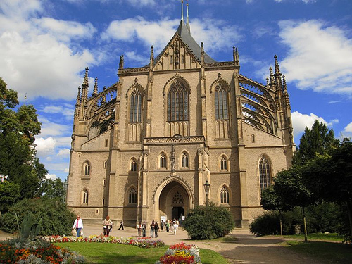
This late-Gothic masterpiece—often called a cathedral despite being a
parish church—dominates Kutná Hora’s skyline and stands as the town’s
most iconic landmark. Dedicated to Saint Barbara, patron saint of
miners, it symbolizes the silver wealth that funded its construction.
Building began in 1388 under architect Jan (Johann) Parler (son of Peter
Parler, master of Prague’s St. Vitus Cathedral), with later
contributions from Matěj Rejsek, Benedikt Rejt, and others. Work spanned
over 500 years, interrupted by mining declines, Hussite wars, and fires;
it was not fully completed until 1905 after a major Gothic Revival
restoration by Josef Mocker and Ludvík Lábler.
The exterior features
dramatic three-peaked roofs, soaring spires, intricate flying buttresses
(double-arched on the choir), and a forest of pinnacles that create a
crown-like silhouette against the horizon. The original ambitious plan
envisioned a structure twice as large, but economic realities scaled it
back. Inside, the five-aisled hall church boasts a spectacular net
vaulting system (Perpendicular Gothic style), preserved
14th–15th-century frescoes depicting secular mining life (miners at
work, townscapes, and daily activities), stained-glass windows
(including one of Emperor Franz Joseph I), ornate choir stalls from the
late 15th century, and a mix of Gothic and Baroque altars. The Jesuits
added Baroque elements in the 17th century, but the core remains a pure
expression of Bohemian Gothic innovation. As a UNESCO highlight, it
influenced later cathedral designs across Central Europe and remains an
active Roman Catholic church.
Sedlec Abbey Complex: Cathedral of
the Assumption of Our Lady and Saint John the Baptist + Sedlec Ossuary
About 1.5 km northeast of the historic center (a pleasant walk from the
train station), the former Cistercian abbey (founded 1142, the first in
Bohemia) forms the other pillar of the UNESCO site.
The Cathedral
(Church of the Assumption of Our Lady and Saint John the Baptist) is one
of Bohemia’s earliest High Gothic structures (built c. 1300), modeled on
French cathedrals with a basilica plan, choir, transept, and side
chapels. Destroyed by Hussites in 1421, it lay in ruins until a
Baroque-Gothic reconstruction (1700–1708) under architect Jan
Santini-Aichel (also known as Johann Blasius Santini-Aichel), who
pioneered the “Baroque Gothic” style here. Santini’s vaults, facade with
dramatic gables, and statue-adorned antechamber (by Matěj Václav Jäckel)
blend soaring Gothic verticality with Baroque dynamism. The eastern
parts retain original Gothic exteriors; the interior features elegant
ribbed vaults and a reliquary with relics of St. Vincent of Saragossa.
Consecrated in 1708, it was restored in 2001 and exemplifies how Baroque
masters reinterpreted Gothic forms.
The Sedlec Ossuary (Kostnice v
Sedlci, or “Bone Church”), beneath the Cemetery Church of All Saints, is
one of the world’s most macabre and visited attractions (over 200,000
visitors annually). In 1278, an abbot sprinkled soil from Golgotha
(Jerusalem) over the abbey cemetery, making it a coveted burial ground.
The Black Death (14th century) and Hussite Wars (15th century) filled it
with tens of thousands of bodies. Around 1400, a Gothic chapel was built
above a lower ossuary. In 1870, woodcarver František Rint (hired by the
Schwarzenberg family) artistically arranged 40,000–70,000 bones into: a
central chandelier (containing every human bone type), skull garlands
draping the vaults, bone pyramids in corners, monstrances and piers
flanking the altar, and the Schwarzenberg coat of arms. Rint even signed
his work in bone near the entrance. The upper chapel was rebuilt in
Baroque style by Santini (1703–1710). It is both a memento mori and a
stunning feat of folk artistry—eerie, reverent, and unforgettable.
Italian Court (Vlašský dvůr)
This Gothic palace complex in the
town center originally served as a royal residence and, from the early
14th century until 1727, the royal mint where Prague groschen coins were
struck. Built c. 1260–1300 as part of early fortifications, it features
a prominent southeast tower, a beautiful 1400 Gothic royal chapel with
stellar vaulting and frescoes, arcaded courtyards, and later
Renaissance/Baroque additions. Today it houses a museum on minting
history and coin exhibitions. The name “Italian” likely refers to
Italian mint masters invited by King Wenceslaus II. It is a tangible
link to Kutná Hora’s economic golden age and a highlight of the medieval
urban core.
Hrádek (Little Castle) and Silver Mine
Originally
a 14th-century medieval fortress guarding the mines, Hrádek was rebuilt
as a Gothic palace in the 15th–16th centuries and later used as a Jesuit
seminary. It now houses the Museum of Silver (part of the Czech Museum
of Silver), with exhibits on mining technology, tools, and town history.
Adjacent is an authentic underground silver mine tour (about 300 m deep,
cool and damp—bring a jacket). Visitors descend via original shafts to
see medieval mining techniques, ore veins, and historical
reconstructions. It provides the most immersive understanding of why
Kutná Hora exists.
Other Notable Landmarks in the Historic Centre
Rejsek’s Stone Fountain (Kamenná kašna, 1495) — A unique late-Gothic
dodecagonal (12-sided) fountain by Matěj Rejsek, carved from stone to
supply water after mining disrupted natural sources. It is a technical
and artistic gem in the main square.
Jesuit College (1666–18th
century) — Early Baroque building by Giovanni Domenico Orsi and Carlo
Lurago, with a grand terrace offering panoramic views of St. Barbara’s
Church and sculpted figures by František Baugut. It once educated the
elite and now hosts cultural events.
Church of Saint James the
Greater — 14th-century Gothic church with an 80 m tower; one of the
town’s earliest monumental structures.
Plague Column (1714–1715) —
Baroque monument by František Baugut commemorating a 1713 plague,
featuring miner statues and a pietà—symbolizing the town’s resilience.
Stone House (Kamenný dům) — Late-Gothic burgher mansion (1480s) with
ornate facade, now part of the silver museum.
Kutná Hora (often spelled Kutna Hora) is a UNESCO World Heritage Site
in Central Bohemia, Czech Republic, about 70-80 km east of Prague. This
compact medieval silver-mining town rivals Prague in historical
significance and offers stunning Gothic architecture, eerie bone art,
and a charming old town far less crowded than the capital.
It makes
an ideal day trip or relaxed overnight stay, with most sights walkable.
Its silver wealth in the 13th-16th centuries funded grand buildings and
made it a royal mint and economic powerhouse.
Brief History
Silver discovery in the 13th century transformed Kutná Hora into a
booming settlement. King Wenceslaus II issued a mining code in 1300, and
the town minted Prague groschen coins, fueling Central European trade.
It competed with Prague until silver declined in the 16th century due to
depleted mines, wars, floods, and plagues. Many Gothic and later Baroque
structures survive, earning UNESCO status in 1995 for their cultural and
architectural value.
The Sedlec area features a Cistercian abbey
(founded 1142) whose cemetery inspired the famous Ossuary.
Best
Time to Visit
Kutná Hora shines year-round. April-October offers
pleasant weather, longer days, and full museum/mine access, though
weekends and summer bring day-trippers.
Early autumn
(September-October) provides colorful foliage and fewer crowds for
photography. Visit mid-week or early morning to beat bus tours. Winters
are quieter with possible snow but shorter hours for some sites (e.g.,
underground mine may close).
How to Get There from Prague (and
Elsewhere)
Train (recommended): Frequent direct or easy-change trains
from Prague’s main station (Praha hl.n.) take ~1-1.5 hours. Get off at
Kutná Hora–Sedlec for the Ossuary or continue to Kutná Hora město
(closer to center) or hl.n. (main station, ~3 km walk/bus to center).
Tickets are cheap (~2-4 EUR one way). Check ČD.cz.
Bus: Slower (~2
hours) from Prague’s Florenc or Háje.
Car: ~1 hour drive via D11
highway. Parking is available near the center or attractions.
Guided
Tours: Many from Prague include transport, entries, and
guides—convenient for first-timers.
Pro Tip: Trains often stop
conveniently near Sedlec first. Plan your route accordingly.
Top
Attractions and Visiting Tips
Focus on these highlights. A combined
ticket for major churches/Ossuary saves money.
Sedlec Ossuary
(Bone Church / Kostnice): The star attraction—a small Gothic chapel
decorated with bones of 40,000-70,000 people, arranged into chandeliers,
coats of arms, pyramids, etc. Created in 1870 by woodcarver František
Rint. Solemn yet artistic; photography often restricted inside.
Tips:
Visit early to avoid crowds. Combine with the nearby Cathedral of the
Assumption of Our Lady and St. John the Baptist (Cistercian, grand
interior). Allow 30-45 min per site. Tickets on-site or online.
St. Barbara’s Cathedral (Chrám sv. Barbory): Stunning late-Gothic
masterpiece (started 1388, finished 1558), dedicated to miners’ patron
saint. Flying buttresses, three-peaked roof, rich frescoes, stained
glass, and vaulted ceilings inside. One of Central Europe’s finest
Gothic churches.
Tips: Admire from multiple viewpoints (Kremnická
street, terrace by Jesuit College, rooftop of Corpus Christi Chapel).
Climb for panoramas. Allow 45-60+ min inside. Check for services.
Czech Museum of Silver (Hrádek) & Medieval Mine: Interactive
exhibits on mining history, coins, and geology. Take the “Journey of
Silver” tour (helmet, coat, headlamp) into real medieval tunnels.
Tips: Guided tours (book ahead in peak season); great for understanding
the town’s wealth. Mint your own souvenir coin.
Italian Court
(Vlašský dvůr): Former royal mint and residence. Beautiful courtyard,
chapel, and minting museum.
Jesuit College (now GASK Gallery) &
Baroque Sculptures: Impressive Baroque building with modern art
exhibitions and gardens. Adjacent statues enhance the walk to St.
Barbara’s.
Church of St. James (Kostel sv. Jakuba): Tall tower,
Gothic interior, organs, and viewpoints.
Old Town & Surroundings:
Wander cobblestone streets, main square (Palackého náměstí), charming
lanes, parks, and viewpoints. Explore lesser museums in historic houses.
Suggested Itinerary (Full Day):
Morning: Arrive Sedlec → Ossuary
+ Assumption Cathedral. Walk/transfer to center → Italian Court, Silver
Museum, St. James, Old Town lunch. Afternoon: St. Barbara’s + Jesuit
area, viewpoints, leisurely stroll. Evening: Relax with views or dinner.
Photography Tips: Golden hour for St. Barbara’s exteriors; respect
no-photo rules in Ossuary.
Food and Drink Recommendations
Traditional Czech cuisine shines here: duck, pork schnitzel, goulash,
dumplings, and local beers.
Dačický Restaurant: Highly rated for
authentic Czech dishes, historic atmosphere, and Kutná Hora beer.
Restaurace V Ruthardce: Popular for steaks, barbecue, Czech classics,
and garden views.
Other options: Factory Bistro, local spots for
lighter fare or wine (near vineyards).
Try wild boar goulash or roast
duck. Many places offer outdoor seating in good weather.
Accommodations
Stay overnight for a magical, crowd-free evening.
Options range from historic hotels in the center to guesthouses. Central
locations make everything walkable. Check booking sites for current
deals.
Practical Tips
Walking: Compact and
pedestrian-friendly; wear comfortable shoes for cobblestones and slight
hills.
Tickets & Hours: Buy combined tickets; check official sites
for seasonal variations (e.g., Ossuary ~9/10 AM–4/6 PM).
Crowds &
Etiquette: Early starts beat tour groups. Be respectful in religious
sites.
Currency & Language: CZK (cards widely accepted);
English/German common in tourist spots.
Accessibility: Some sites
(mines, towers) have stairs; check ahead.
Nearby: Combine with Kolín
or extend to other Bohemian towns.
Safety: Low-risk; standard
precautions.
Kutná Hora rewards slower exploration—its silver legacy,
architectural grandeur, and unique sites like the Bone Church create an
unforgettable Czech experience. Perfect for history buffs,
photographers, and those seeking an authentic escape from Prague.
Origins and the Silver Rush (10th–13th Centuries)
Human activity
in the area dates back to the Bronze and Iron Ages, with Celtic
settlements and early mining traces on Kaňk hill. Silver deposits were
known by the 10th century (dinars from 985–995 have been found nearby),
but large-scale mining began around 1260. This attracted German-speaking
settlers and created several unnamed mining camps. The first documented
mention of the town appears in 1289 as Mons Cuthna (Mining Mountain), a
name reflecting the Czech word kutání for digging or mining.
In 1142,
monks from Waldsassen Abbey in Bavaria founded Sedlec Abbey (the first
Cistercian monastery in Bohemia) just outside the future town. The abbey
later became enormously wealthy thanks to the silver boom and played a
central role in the region’s religious and economic life. By the late
13th century, the discovery of rich surface silver veins triggered a
true “silver rush,” rapidly populating the area.
The Medieval
Boom and Royal City (Late 13th–Early 15th Centuries)
The turning
point came in 1300 when King Wenceslaus II issued the Ius regale
montanorum (“Royal Mining Law”), the first comprehensive mining code in
Central Europe. It regulated claims, taxation, and operations, while
establishing Kutná Hora as the seat of the central royal mint for the
entire Czech lands. The mint operated in the Vlašský dvůr (Italian
Court), originally a small royal castle later expanded with Gothic
features. Here, the famous Prague groschen (a highly stable silver coin)
was struck and circulated across Europe, making Kutná Hora the kingdom’s
financial powerhouse.
The town received royal privileges, grew
rapidly, and rivaled Prague in importance during the 14th century.
Magnificent buildings rose: the Church of Saint Barbara (construction
began 1385–1388 under master builders including members of the Parler
family workshop) was built outside the walls as a miners’ cathedral, its
flying buttresses and frescoes depicting everyday mining life. The
Cathedral of Our Lady at Sedlec (part of the Cistercian abbey) and the
Italian Court itself became symbols of prosperity. The town’s medieval
street plan, dictated by mining shafts and ore veins, remains largely
intact today.
In 1409, King Wenceslaus IV signed the Decree of Kutná
Hora in the town, strengthening the Czech “nation” at Prague
University—an important moment in Czech national consciousness. At its
peak, Kutná Hora was a wealthy, cosmopolitan royal city with a mixed
German-Czech population and a sophisticated urban culture.
Hussite Wars, Fires, and Turmoil (15th Century)
The Hussite Wars
(1419–1434) brought devastation. In 1420–1421, the town served as a base
for Sigismund’s forces but was captured and burned by Hussite troops;
Sedlec Abbey was sacked and its library destroyed. German inhabitants
were partly expelled, and major fires in 1422 and 1424 further damaged
the town. The wars and subsequent plague epidemics left thousands dead;
their bones were later collected and used in the famous Sedlec Ossuary.
Mining briefly halted but resumed around 1469. The Religious Peace of
Kutná Hora (1485) helped stabilize Bohemia’s religious divisions.
Decline of Mining and Later Centuries (16th–19th Centuries)
Silver production peaked in the late 15th century but declined sharply
from the 1530s due to flooding, exhausted rich veins, and technical
limits. The last Prague groschen were minted in 1547; major mining
operations ceased by 1625. The Thirty Years’ War (1618–1648) brought
Swedish raids (1639, 1643), further population loss, and economic
hardship. Jesuits arrived in 1626 and built a college, turning the town
into an educational center.
In the 18th century, thin new silver
veins were discovered but proved unprofitable. The mint closed in 1727.
Fires (notably 1730 and 1770) and plagues continued to affect the town,
yet Baroque rebuilding occurred: the Sedlec Cathedral was dramatically
restored in a unique “Baroque-Gothic” style by architect Jan Blažej
Santini-Aichel (early 1700s), introducing a new architectural language
that influenced Central Europe. The Sedlec Ossuary was artistically
arranged with 40,000–70,000 skeletons by František Rint in 1870. A
tobacco factory opened in the former monastery in 1812 (later becoming
Philip Morris).
20th Century to Present
After 1918, Kutná Hora
became part of Czechoslovakia. The Jewish community was destroyed during
the Nazi occupation (1939–1945). Under communism, the last silver mines
closed, and industry shifted (electronics and tobacco remain major
employers today). The historic center was declared an urban monument
reservation in 1961.
In 1995, UNESCO inscribed the “Historic Centre
of Kutná Hora with the Church of St Barbara and the Cathedral of Our
Lady at Sedlec” on the World Heritage List under criteria (ii) and (iv).
It recognizes the town as an outstanding example of a medieval mining
city whose prosperity shaped Central European architecture and urban
planning, with the Church of St Barbara and Santini’s Sedlec Cathedral
exerting wide influence. The site covers 62 ha with a large buffer zone;
authenticity and integrity remain exceptionally high.
Today, with
around 21,000 inhabitants, Kutná Hora thrives on tourism. In 2023 alone,
the Church of St Barbara welcomed 250,000 visitors and the Sedlec
Ossuary 290,000—making them among the Czech Republic’s most-visited
sacred sites. The town preserves its medieval layout, Gothic and Baroque
treasures, and underground mine tours, offering a vivid window into
Bohemia’s silver age.
Topography and Terrain
The town's topography reflects a transition
between two distinct geomorphological units within the broader Bohemian
Massif. The eastern part of the municipal territory occupies a flat to
gently undulating agricultural landscape in the Central Elbe Table
(Středolabská tabule), characterized by open farmland and low relief. In
contrast, the western part rises into the Upper Sázava Hills
(Hornosázavská pahorkatina), featuring more varied terrain with gentle
hills, valleys, and modest slopes.
The average elevation of the town
is around 254–274 m (833–899 ft) above sea level. The highest point
within the municipal territory is the hill Malý Kuklík at 359 m (1,178
ft). Broader topographic data for the immediate area indicate a minimum
elevation near 201 m (659 ft) and a maximum around 407 m (1,335 ft) when
including surrounding slopes. The historic town center sits on a high
tableland above the Vrchlice valley, creating a "dizzying" spread over
gentle hills and contributing to the picturesque, layered urban layout
visible in aerial views.
This relief transition influences land use:
flat eastern areas support intensive agriculture (cereals, root crops),
while western hills feature more forests, meadows, and scattered
settlements. The district as a whole extends into additional units like
the Vlašim Uplands and Iron Mountains, but the town's core remains
dominated by the tableland-hills interface. No major natural hazards
dominate, though historical mining and occasional flash flooding (tied
to the local stream) have shaped the landscape.
Geology and
Mineral Resources
Kutná Hora lies within the Kutná Hora Complex (or
ore district), a crystalline geological formation in fault contact with
Cretaceous sediments and other units (such as Oheb gneiss). The bedrock
consists primarily of gneiss and other metamorphic rocks from the Kutná
Hora crystalline complex, with ore veins concentrated near the contact
zone with basal chalk conglomerates.
The area's defining feature is
its rich silver-bearing polymetallic ore deposits (primarily silver,
with later lead-zinc ores). Ore lodes (known locally as "pásmo" or
"Zug") vein the surrounding hills, especially around Kaňk hill. Silver
exploitation began in the late 10th–13th centuries (with even earlier
Celtic traces from the Hallstatt/La Tène periods involving copper and
other minerals). Mining reached depths of up to 500 m and produced
around 90% of Bohemia's silver at its medieval peak, funding the royal
mint and the town's rapid growth. Operations declined in the 16th
century due to flooding, ore depletion, and technical limits; the last
significant activity ceased by the 17th–18th centuries. Underground
galleries (some preserved and tourable today) were dug directly into the
gneiss. This geology not only drove the town's medieval prosperity but
also left legacies like subsided ground, disrupted water tables, and
preserved mine infrastructure.
Hydrology and Water Features
The primary watercourse is the Vrchlice Stream (Vrchlice), a left-bank
tributary of the Klejnárka River (which ultimately feeds the Elbe/Labe
system). The Vrchlice originates in the Upper Sázava Hills at 488 m
elevation (near Černíny) and flows 30 km before joining the Klejnárka at
about 204 m. Its drainage basin covers 133.3 km², and it passes directly
through Kutná Hora on the edge of the Vrchlice valley. The stream is
"flashy" — highly reactive to rainfall — and can run dry during
prolonged droughts, while its basin supplies drinking water to the town
via a reservoir.
Mining historically disrupted local aquifers and
springs, prompting medieval engineering solutions like the
dodecagon-shaped Rejsek's Fountain (built 1495) as a public reservoir.
The broader district features additional Elbe tributaries (Doubrava,
Klejnárka), but within the town, the Vrchlice and minor tributaries
dominate surface hydrology. Occasional flooding has occurred (e.g.,
historical events linked to regional Vltava/Elbe floods), though no
major modern catastrophic events are tied specifically to the town.
Climate
Kutná Hora experiences a warm and temperate climate
classified as Cfb under the Köppen-Geiger system (fully humid, warm
summers, no dry season). It is influenced by its inland Central European
position: moderate continental effects tempered by Atlantic air masses,
with no extreme maritime or high-mountain moderation. Annual mean
temperature is 9.4 °C (48.8 °F), with a fluctuation of about 20 °C
across the year. Annual precipitation totals 759 mm (29.9 in),
distributed fairly evenly but with a summer maximum; the driest month is
February (41 mm) and the wettest is July (95 mm). Precipitation occurs
on roughly 132 days annually.
Monthly averages (temperature in °C
and precipitation in mm) are as follows:
January: −0.8 (min −3.5, max
1.9) / 49 mm
February: 0.2 (min −3.1, max 3.7) / 41 mm
March: 4.0
(min −0.4, max 8.4) / 55 mm
April: 9.3 (min 3.9, max 14.3) / 50 mm
May: 13.9 (min 8.7, max 18.5) / 78 mm
June: 17.4 (min 12.3, max 21.7)
/ 86 mm
July: 19.3 (min 14.3, max 23.7) / 95 mm
August: 19.0 (min
14.1, max 23.7) / 83 mm
September: 14.5 (min 10.2, max 18.8) / 70 mm
October: 9.7 (min 6.2, max 13.4) / 49 mm
November: 4.9 (min 2.3, max
7.7) / 51 mm
December: 0.8 (min −1.5, max 3.3) / 52 mm
Summers
(June–September) are balmy and the wettest period, with highs reaching
21–24 °C. Winters are mild but can dip below freezing (rare extremes
below −13 °C). Snowfall is possible but not dominant. Cloud cover,
humidity, and winds are moderate, with no strong seasonal extremes noted
beyond typical Central European patterns. The varied local relief (hills
vs. tableland) creates minor microclimatic differences, such as slightly
cooler, more sheltered valleys.
Human and Historical Geography
Ties
The geography profoundly shaped human settlement and economy.
Silver ore in the hills spurred rapid 13th–14th-century growth, turning
a minor settlement into a royal city rivaling Prague. The town’s layout
hugs the Vrchlice valley edge and tableland, with fortifications and
Gothic landmarks (e.g., St. Barbara’s Church, Sedlec Monastery)
positioned for defense and visibility. The historic center (61 ha urban
monument reservation) and UNESCO World Heritage Site (inscribed 1995)
preserve this mining-driven morphology. Modern land use blends preserved
heritage with agriculture in the east and light industry/tourism.
Surrounding protected landscapes and the district’s mix of flat farmland
and forested hills support recreation and biodiversity.
Kutná Hora emerged in the late 13th century due to rich silver
deposits, quickly becoming Bohemia’s second-most important city after
Prague by the 14th century. It served as a royal city with a mint
(Vlašský dvůr / Italian Court) that produced Prague groschen coins,
symbolizing economic power.
The Church of St Barbara (dedicated to
the patron saint of miners) stands as a late-Gothic masterpiece, begun
in the late 14th century and completed over centuries. Its flying
buttresses, pinnacles, and frescoes depicting mining life and daily
medieval existence make it one of Central Europe’s most significant
Gothic churches. It profoundly influenced regional architecture.
Nearby in Sedlec, the Cathedral of the Assumption of Our Lady and St.
John the Baptist (a former Cistercian monastery church) blends Gothic
roots with early 18th-century Baroque-Gothic restoration by Jan Blažej
Santini-Aichel. This style became influential. Adjacent is the
world-famous Sedlec Ossuary (Kostnice), a chapel decorated with the
bones of tens of thousands (victims of plagues and wars), featuring
chandeliers, coats of arms, and other macabre art that reflects medieval
attitudes toward mortality and the transience of life.
Other
landmarks include the Italian Court (with its Gothic royal chapel and
mint history), the Stone House (Kamenný dům, a prime late-Gothic
bourgeois residence), the Stone Fountain, and the Hrádek (little
castle), now part of the Czech Silver Museum. These structures preserve
a medieval street plan shaped by mining, with Gothic and Baroque private
homes showcasing the town’s layered history.
Religious and
Spiritual Traditions
Catholic heritage runs deep, tied to mining
spirituality (St. Barbara) and monastic roots (Sedlec Cistercians). The
churches remain active sites for worship, while the Ossuary serves as a
contemplative space on death and eternity. Religious festivals and
processions historically marked the calendar, blending faith with
community life.
Festivals and Living Traditions
Kutná Hora
actively celebrates its heritage. Královské stříbrění (Royal Silvering)
reenacts 15th-century life with parades, crafts, and historical
spectacles. The town marked 30 years of UNESCO status in 2025 with
events like the Festival of Light (illuminating monuments), art
exhibitions (e.g., at GASK), music festivals (A Day of Sound), theater
revivals, and interactive tours.
Wine culture thrives due to the
region’s vineyards. Local cellars (some historic) host tastings,
especially whites. Events like the Gastrofestival (May) pair food and
wine, while harvest festivals in September feature street art and
celebrations. These events foster community and tourism.
The GASK
Gallery (in a Baroque Jesuit College) highlights 20th–21st century
figurative Czech art alongside historical ties, with educational
programs, temporary exhibits, and panoramic views. It bridges medieval
roots with contemporary creativity.
Cuisine and Gastronomic
Culture
Local fare reflects Bohemian traditions: hearty meats,
dumplings, sauces, and seasonal ingredients. Pubs and restaurants serve
classic Czech dishes with local beer. The growing modern scene includes
creative bistros and food trucks alongside traditional options.
Wine
production adds distinction, with cellars offering tastings in
atmospheric settings (e.g., Ursuline Monastery). Festivals emphasize
pairings of local wines, organic foods, and regional specialties,
showcasing hospitality and agricultural heritage.
Mining and Folk
Heritage
Underground tours at the Czech Silver Museum let visitors
experience historic tunnels, highlighting miners’ lives and the industry
that funded the town’s monuments. This industrial heritage informs local
identity, crafts, and storytelling.
Folklore, music, and crafts
persist through festivals and museums. The preserved urban layout and
landscape integration maintain a strong sense of place.
Modern
Cultural Life
Today, Kutná Hora blends tourism with vibrant local
life. It hosts music festivals, theater, contemporary art, and events
tied to pop culture (e.g., Kingdom Come: Deliverance game routes). As a
day trip from Prague or longer-stay destination, it balances heritage
preservation with community vitality, supported by UNESCO protections
that guide development.