Location: Plzeň and South Bohemian Regions Map
Area: 680.64 km² (263 sq mi)
Official site
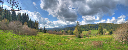
Šumava National Park (Národní park Šumava), often called the "Green Roof of Europe," is the largest national park in the Czech Republic, spanning 68,064 hectares (680 km²) in the South Bohemian and Plzeň Regions along the border with Germany and Austria. Established in 1991, it forms the core of the Šumava Biosphere Reserve, designated by UNESCO in 1990, and is contiguous with the Bavarian Forest National Park in Germany, creating one of Europe's largest protected forested areas. The park is renowned for its pristine mountain forests, glacial lakes, extensive peat bogs, and diverse ecosystems, serving as a vital habitat for rare and endangered species. It attracts over a million visitors annually for hiking, wildlife watching, and ecological education, while emphasizing sustainable conservation amid challenges like climate change and bark beetle infestations.
Šumava National Park (Národní park Šumava), also known as Bohemian
Forest National Park, is the largest national park in the Czech
Republic, covering approximately 680–681 km² (263 sq mi). Established in
1991, it protects a significant portion of the Šumava (Bohemian Forest)
mountain range in southwestern Czechia, primarily in the South Bohemian
Region, with parts extending into the Plzeň Region. It borders Germany’s
Bavarian Forest National Park to the west and Austria to the south.
Together with the adjacent Bavarian Forest, it forms the largest
contiguous forested area in Central Europe, often called the “green roof
of Europe” due to its location and vast woodlands.
Location and
General Layout
The park stretches roughly 100 km in length and up to
20 km in width along the border. It lies in the northeastern part of the
Bohemian Forest (a Hercynian middle-mountain range north of the Alps),
near the geographical center of Europe. The main ridge, often subtle,
follows the Czech-German border, with the southernmost sections reaching
Austria.
Elevations range from around 490–600 m in lower valleys and
foothills to a maximum of 1,379 m (Plechý/Plöckenstein) on the Austrian
border. Much of the park sits above 1,000 m, representing one of the
largest continuous high-elevation areas in Czechia.
Topography
and Landforms
Šumava features a distinctive landscape of rounded,
ancient mountains, extensive upland plateaus (known as Šumava Plains),
and deeply incised valleys. These plateaus are among the oldest relicts
of paleorelief in Europe, shaped by long-term tropical weathering,
denudation, and Pleistocene cryogenic/glacial processes.
Plateaus
and plains: Central areas include flattened summits and relict surfaces
at multiple levels (e.g., above 1,000–1,100 m and around 750 m), divided
by denudation steps. These create broad, gently rolling highlands.
Valleys: Deep, erosional valleys (e.g., Vydra and Křemelná rivers)
contrast with the flat plateaus, featuring steep slopes, gorges, and
retrograde erosion influenced by faults.
Peat bogs and wetlands: Many
plateaus host raised peat bogs (mires), a hallmark of the park. These
post-glacial features cover significant areas and include unique
habitats like floating islets and stunted vegetation.
The terrain
is generally not sharply alpine but consists of rolling forested hills,
plateaus, and grasslands, with the highest ridges along the
international border.
Geology
The underlying geology belongs
to the Bohemian Massif (part of the larger Hercynian/Variscan orogeny).
Key units include:
Moldanubicum: Medium to strongly metamorphic
rocks, dominated by paragneiss, migmatites, quartzites, and erlans.
Moldanubic pluton: Granite massifs (e.g., Prášily, Vydra River, Plechý)
from Variscan/Upper Paleozoic intrusions (around 316–349 million years
old).
The landscape reflects ancient tectonic collisions,
volcanic activity, erosion over hundreds of millions of years, and
faulting during the Alpine orogeny. Pleistocene glaciation left glacial
lakes and shaped cirques.
Hydrology
Šumava is a critical
watershed divide between the North Sea (via the Vltava/Elbe) and Black
Sea drainages. It serves as an important mire and spring area in Central
Europe.
Rivers: Major watercourses include the Vltava (Moldau,
Czechia’s longest river, with its headwaters here), Otava, Vydra,
Křemelná, and Řezná/Uhlava. Rivers often feature wild, meandering
sections in valleys and pristine floodplains.
Glacial lakes: Iconic
post-glacial features include Černé jezero (Black Lake — the largest and
deepest natural lake in Czechia), Čertovo jezero (Devil’s Lake), Plešné
jezero, Prášilské jezero, and Laka. These are typically deep, clear, and
surrounded by steep forested slopes.
Peat bogs and mires: Extensive
wetlands, many historically drained but now subject to restoration, play
a key role in water retention, carbon storage, and biodiversity.
Examples include Tříjezerní slať (Three Lakes Moor) and Soumarské
rašeliniště.
Climate
The climate is humid temperate with
montane characteristics. Precipitation is high (800–1,600 mm/year along
the main ridge), with maxima in July and minima in April. Higher
elevations experience cooler temperatures, more snow, and frequent fog.
The area is prone to strong winds, which have caused significant
windthrows (e.g., Kyrill in 2007).
Vegetation and Landscape
Mosaic
About 80% of the park is forested, dominated by Norway spruce
(often plantations, including non-native varieties vulnerable to bark
beetle and wind). Remnants of primeval mixed forests (beech, fir,
spruce) persist in places like Boubín. Non-forest habitats include peat
bogs, grasslands, and waterlogged areas, supporting high biodiversity.
Šumava’s geography creates a mosaic of habitats: dense forests, open
plateaus with bogs, river valleys, and glacial features, making it a
vital ecological corridor in Central Europe.
Pre-Modern and Early Human History
The geological foundations of
the Šumava mountains date back hundreds of millions of years to the
Variscan Orogeny, forming part of the Bohemian Massif. The landscape
features ancient forests, glacial lakes, raised peat bogs, and plateaus
shaped by natural processes over millennia.
Human presence in the
broader region is ancient, but intensive settlement and impact on the
higher elevations of Šumava were relatively delayed. Small communities
existed along trading routes in the foothills, with more significant
colonization occurring in the 12th–13th centuries during the medieval
period. Higher ridges remained largely untouched until the 18th century,
when glassworks and other industries drove deforestation and settlement.
By the 19th century, extensive logging (especially of beech) and human
activities had altered the natural forest composition, shifting it
toward spruce-dominated plantations, many using non-native varieties
less adapted to the local climate. Remnants of primeval forests, such as
the well-known Boubínský prales (Boubín Primeval Forest), were protected
early—one of the first nature reserves in Bohemia in 1858.
Major
natural disturbances, including windstorms in the 1860s–1870s followed
by bark beetle outbreaks, significantly shaped the forests, affecting
large areas and becoming part of local ecological memory.
20th
Century Up to 1989: Expulsions, Iron Curtain, and Early Protection
The 20th century brought dramatic human changes. The population was
predominantly German-speaking until after World War II. Post-war
expulsions (often called the Sudeten expulsions) led to the forced
removal of most inhabitants. Many villages were abandoned or razed,
leaving ruins that still dot the landscape today as silent witnesses to
this turbulent history.
During the Communist era (1948–1989), Šumava
became part of the heavily militarized Iron Curtain zone along the
border with West Germany (and Austria). Access was severely restricted,
with watchtowers, barriers, tripwires, and patrols. This isolation,
while tragic for local communities and escape attempts, inadvertently
allowed nature to recover and develop with minimal human
interference—preserving biodiversity, forests, and wilderness qualities.
In 1963, the Czechoslovak government established the larger Šumava
Protected Landscape Area (CHKO Šumava), covering about 1,686 km², to
safeguard the region’s unique ecosystems. This was one of the largest
such areas in the former Czechoslovakia at the time.
Establishment of the National Park (1990s)
The Velvet Revolution in
1989 opened the borders and the region to the public. In February 1990,
the area was designated a UNESCO Biosphere Reserve. On 20 March 1991,
the most ecologically valuable core section (roughly two-thirds of the
original PLA) was officially declared Šumava National Park, with the
remaining parts of the PLA serving as a buffer zone. This occurred
alongside the creation of Podyjí National Park—the same year, marking a
major expansion of Czech national parks post-Communism.
The park’s
creation aimed to protect extensive spruce and beech forests, peat bogs,
glacial lakes, rivers, and species like lynx (re-established in the
1970s). It forms a transboundary protected area with Germany’s Bavarian
Forest National Park, promoting cross-border cooperation that has earned
multiple awards.
Post-Establishment Challenges and Controversies
The park’s history since 1991 has been marked by intense debates, making
it one of the most polarizing protected areas in the Czech Republic. Key
issues include:
Forest Management and Bark Beetle Outbreaks:
Major outbreaks occurred in the mid-1990s and after the 2007 Cyclone
Kyrill windstorm (which felled about a million cubic meters of wood in
Šumava). Conflicts arose between advocates of non-intervention (letting
natural processes, including bark beetle dynamics, play out to foster
wilderness) and those favoring active intervention (logging to protect
timber values or neighboring forests). Different park directors often
shifted approaches, leading to inconsistency.
Local Communities and
Economy: Tensions with remaining locals and businesses over restrictions
on development, tourism, and traditional uses. Many viewed strict
protection as limiting economic opportunities in a depopulated region.
Zonation and Management Evolution: Initial zonation (1990s) evolved
significantly. A major legislative amendment in 2017 clarified goals for
Czech national parks, emphasizing non-intervention in core areas while
supporting sustainable development elsewhere. By the early 2020s, new
zonation included four zones, with ambitions to expand non-intervention
areas to 52% by 2035 and 75% by 2060.
Despite conflicts, the park
has seen successes: improved transboundary cooperation, biodiversity
gains in non-intervention zones, and growing tourism focused on
education and nature experience. Monitoring shows natural processes
enhancing wilderness qualities in many areas.
Current Status and
Significance
Today, the park (administered by Správa NP a CHKO
Šumava) balances strict nature protection with visitor access through
trails, information centers, and educational programs. It remains a
vital refuge for rare species and habitats, with significant primeval
forest remnants and peatlands. Its history reflects broader European
themes: medieval colonization, industrial exploitation, wartime
expulsions, Cold War division, and post-1989 reconciliation with nature
through conservation.
Šumava's flora exhibits lower species diversity compared to the Alps or Carpathians due to uniform geology and dominant forest cover, lacking a true subalpine zone. Forests dominate, with Norway spruce (Picea abies) comprising 80% of stands, alongside silver fir (Abies alba), European beech (Fagus sylvatica), sycamore maple (Acer pseudoplatanus), and mountain ash (Sorbus aucuparia). Efforts focus on restoring natural mixed forests to replace monocultures. Non-forest habitats include peat bogs with sphagnum mosses, sundews (Drosera spp.), and bog pines (Pinus rotundata). Alpine meadows feature rare plants like the Šumava violet (Viola lutea ssp. sudetica) and glacial relics such as dwarf birch (Betula nana). Spring areas and rock cliffs host unique communities, with over 1,200 vascular plant species recorded, including endemics adapted to nutrient-poor soils.
The park's fauna is diverse, influenced by both natural forests and human-modified landscapes. Large mammals include Eurasian lynx (Lynx lynx), reintroduced in the 1980s, gray wolves (Canis lupus) naturally returning since the 1990s, and European wildcats (Felis silvestris). Brown bears (Ursus arctos) are absent but occasionally sighted. Ungulates like red deer (Cervus elaphus), roe deer (Capreolus capreolus), and wild boar (Sus scrofa) are common. Bird species exceed 200, with capercaillie (Tetrao urogallus), black grouse (Tetrao tetrix), and peregrine falcons (Falco peregrinus) as highlights. Amphibians and reptiles include fire salamanders (Salamandra salamandra) and adders (Vipera berus). Invertebrates thrive in deadwood habitats, supporting species like the rosalia longicorn beetle (Rosalia alpina). The park's isolation has preserved glacial relict species, with ongoing monitoring for biodiversity conservation.
Šumava boasts high biodiversity, with preserved old-growth forests, wetlands listed under the Ramsar Convention, and NATURA 2000 sites. It hosts glacial relics and endemic species, serving as a genetic reservoir. Conservation follows a zoning system: core zones (15% of area) for non-intervention, buffer zones for limited activities, and transition zones for sustainable use. Challenges include bark beetle outbreaks, acid rain effects from the 1980s, and climate change impacting spruce monocultures. Management promotes natural regeneration, cross-border cooperation with Bavaria, and community involvement. The park's non-intervention policy in core areas allows natural processes, though controversial during pest outbreaks. Research and monitoring under UNESCO support adaptive strategies, with successes in lynx and wolf populations.
Key attractions include hiking trails (over 500 km), such as the Bear Trail and routes to glacial lakes like Černé jezero (Black Lake) and Plešné jezero. Peat bogs like Chalupská slať offer boardwalks for viewing. Winter activities feature cross-country skiing on 300 km of trails. Visitor centers in Kvilda, Srní, and Kašperské Hory provide exhibits on ecology and history. Rules mandate staying on marked paths, no fires outside designated areas, and leashed dogs. Camping is limited to emergency sites. Ecological education programs, guided tours, and events promote awareness. Access is via regional buses or cars, with entry free but fees for some facilities. The official website (npsumava.cz) offers maps and tips.