Location: Scotland Map
Open: 1 Apr- 30 Sept 9:30am- 6pm
1 Oct- 31 Oct 9:30am- 5pm
1 Nov- 31 Mar 9:30 am- 4:30pm
Tel: 01456 450551
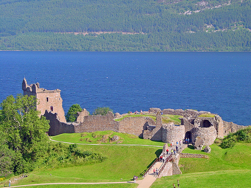
Urquhart Castle is one of the largest and most important medieval castles in Scotland. Urquhart Castle stands on the shore of the Loch Ness Lake close to a village of Drumnadrochit along A82 road. Despite it present poor condition it is still one of the most visited sites in Scotland. This interest lies partially in the castle itself and partially due to numerous sightings of the legendary Nessie that said to inhabit the lake of Loch Ness. This location was used for defensive purposed for the past 4000 years. Unfortunately little information is known from the first hand accounts. The last citadel build here was no later than early 13th century. English kings Edward I captured this castle in 1296 during his campaign against the Scots of the Highlands. The castle changed several times in the course of its history. Unfortunately it was blown up in 1692 by Williamite troops to prevent rebellious Scottish Jacobite forces to use it as their stronghold. The remains of whole portions of walls are still littering of what used to be one of the best defended castles in the region.
Origins and Foundation (Pre-13th Century)
The
site's name, derived from Old Irish and Welsh words meaning "promontory
by the thicket," hints at early occupation. Archaeological evidence,
including vitrified stone from intense heat-fused fortifications, points
to a Pictish fort active between the 5th and 11th centuries on the rocky
knoll at the southwest corner. Adomnán's Life of Columba (c. 697)
describes St. Columba visiting Airdchartdan around 562–586 to convert
the Pictish nobleman Emchath and his son Virolec on their deathbeds,
potentially at this site. Columba's encounter with a "water beast" in
the River Ness is often linked to early Loch Ness Monster lore.
Excavations in 1983 by Professor Leslie Alcock confirmed an extensive
early medieval fort, possibly Emchath's residence.
No definitive
evidence exists for a 12th-century royal castle under William the Lion,
though some historians speculate it may have had royal status. The
documented stone castle began in the early 13th century when King
Alexander II suppressed the Meic Uilleim rebellions in 1229 and granted
the lands to his usher, Thomas de Lundin (later Durward). It passed to
his son Alan Durward, who likely built the initial structures centered
on a motte at the southwest.
Medieval Period and Wars of
Independence (13th–14th Centuries)
The first historical record dates
to 1296 during the Wars of Scottish Independence, when Edward I of
England captured the castle and appointed Sir William Fitz Warin as
constable. In 1297, Scottish leader Andrew de Moray ambushed Fitz Warin
en route from Inverness and laid siege, but the English held out until
relieved. The Scots regained control by 1298, only for Edward to reclaim
it in 1303, granting it to Alexander Comyn.
Robert the Bruce seized
it in 1307 after defeating the Comyns, incorporating it into royal
holdings. It became one of five key Scottish-held castles in 1333. Under
David II (r. 1329–1371), who hunted there in 1342—the only confirmed
royal visit—it was managed by constables like Sir Robert Lauder. Raids
by the MacDonald Lords of the Isles began, with Domhnall of Islay
seizing it in 1395 and holding it for over 15 years.
Later
Medieval and Clan Conflicts (15th–16th Centuries)
The 15th century
saw continued MacDonald aggression: Alexander of Islay raided in 1437,
and John of Islay captured it in 1452 but forfeited it in 1476 after
allying with England. Briefly granted to the Earl of Huntly, it was
awarded to Clan Grant in 1509 by James IV in perpetuity, including Glen
Urquhart estates, on condition of repairs. The Grants rebuilt
extensively, but faced raids, including post-Flodden (1513) by Sir
Donald MacDonald and the devastating "Great Raid" of 1545 by MacDonalds
and Camerons, who looted vast livestock and goods.
A poignant tale
from this era involves Gaelic bard Dòmhnall Donn MacDonald, imprisoned
around 1600 for cattle rustling (or romancing the Grant chief's
daughter), who composed love songs before his execution. Covenanters
robbed it in 1644, reflecting ongoing instability.
Architectural
Developments
Urquhart's layout is triangular on a promontory,
defended by a 30m dry moat, stone causeway, and drawbridge. It features
a figure-of-eight plan with Nether (north) and Upper (south) baileys.
The 13th-century shell keep on the motte included north and south
towers; 14th-century curtain walls were later heightened. The Grant
Tower, a five-storey keep (12x11m, 3m-thick walls), was rebuilt in the
16th century on 14th-century foundations, with bartizans,
machicolations, and a spiral staircase. The Nether Bailey housed the
16th-century gatehouse with D-plan towers, great hall, chambers,
kitchens, and a possible chapel. The Upper Bailey included a
16th-century watergate, doocot, and smithy. Artefacts like the
15th-century Urquhart Ewer, brooches, and coins highlight its domestic
life.
Decline and Destruction (17th–18th Centuries)
Abandoned
by the mid-17th century as clan warfare declined, it was garrisoned by
200 government troops in 1688–1690 during the Jacobite Risings. Besieged
by 500 Jacobites, the defenders held out; upon withdrawal in 1692, they
blew up the gatehouse to deny it to enemies, leaving a large masonry
chunk visible today. Parliament compensated the Grants £2,000, but no
repairs followed. Locals plundered materials, and a 1715 storm collapsed
the Grant Tower's southern wall. By the 1770s, it was a roofless
romantic ruin.
Modern History and Current Status
In the 19th
century, under the Countess of Seafield, it became a tourist attraction.
Transferred to state care in 1913 via the Office of Works (now Historic
Environment Scotland), it was excavated in the 1920s. A visitor centre
and car park were added in 1994–1998. It hosts weddings and features a
full-sized trebuchet replica. With 547,518 visitors in 2019, it holds
awards like Green Tourism gold and a 5-star rating. Culturally, it's
linked to Loch Ness Monster sightings (e.g., 1955 photo, 1977 hoax) and
films like The Private Life of Sherlock Holmes (1970) and Loch Ness
(1996). As a scheduled monument, it offers audio guides and views of
Loch Ness.
Urquhart Castle, dramatically situated on Strone Point along the
northwestern shore of Loch Ness in the Scottish Highlands, is one of
Scotland's largest medieval castles by area and a key strategic site
guarding the Great Glen route and the entrance to Glen Urquhart. The
castle's origins trace back to an early medieval vitrified fort
(5th–11th centuries), with the main stone structures built from the 13th
century onward. It served as a royal stronghold during the Wars of
Scottish Independence, passed through various clans including the
Durwards, Comyns, and MacDonalds, and was granted to the Clan Grant in
1509, who remodeled it extensively. The castle witnessed raids, sieges,
and rebuilds until its partial demolition in 1692 to prevent Jacobite
use, after which it fell into ruin. Today, managed by Historic
Environment Scotland since 1912, it is a major tourist attraction with
over 300,000 annual visitors, offering panoramic views of Loch Ness and
preserved as a romantic ruin.
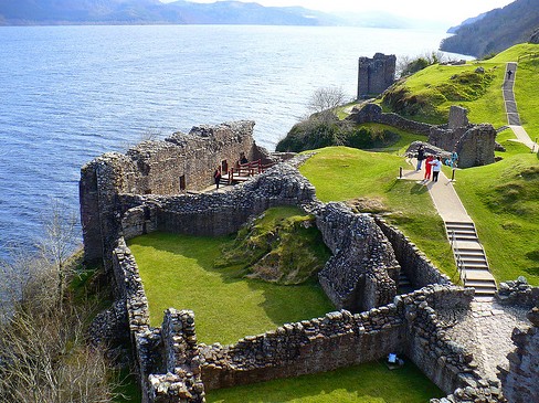
Overall Layout and Site Planning
The castle occupies a triangular promontory jutting into Loch Ness, with
the walled area forming a rough figure-8 (or "spectacles") shape,
measuring approximately 150 meters (492 feet) long by 46 meters (151
feet) at its widest, aligned northeast-southwest. This layout divides
into two main enclosures: the northern Nether Bailey (or Outer Close) on
lower ground, which became the primary focus from the 14th century and
houses most intact ruins, and the southern Upper Bailey (or Service
Close) on higher terrain, centered on a rocky mound that was the site's
earliest fortification. The baileys are connected by a narrow "bridge"
or neck of land at the site's lowest point, with the entire complex
defended by steep slopes to the loch on three sides and a wide dry moat
(up to 30 meters/98 feet across and 5 meters/16 feet deep) on the
landward (western) approach.
Access is via a stone causeway over the
moat, leading to a 16th-century gatehouse; originally, a drawbridge
spanned the moat's center, and the causeway's castle end was walled to
form a barbican-like enclosure for defense. The site's natural
topography—rising from loch level to the southwestern mound (the highest
point)—influenced the layout, with buildings clustered against curtain
walls for protection. Ancillary structures, such as stables and a
smithy, were likely in the Upper Bailey, while the Nether Bailey
contained residential and administrative buildings. Excavations in the
early 20th century and 1983 revealed prehistoric and early medieval
layers, confirming the site's long evolution.
Key Structures:
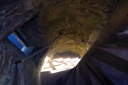
Grant Tower, Gatehouse, and Ranges
The Grant Tower, the castle's
dominant feature and tallest surviving element, anchors the northern tip
of the Nether Bailey. This rectangular tower house measures 12 by 11
meters (39 by 36 feet) with walls up to 3.7 meters (12 feet) thick,
standing about 15 meters (50 feet) high across four to five storeys
(though partially collapsed on the south side due to an 18th-century
storm). Built on 14th-century foundations but largely rebuilt in the
16th century by the Grants, it includes corbelled bartizans (overhanging
corner turrets) at the parapet, machicolations (projecting galleries for
dropping missiles) over the main west door and east postern, and a
circular spiral staircase in the east wall. The interior featured a
first-floor hall, upper chambers, attic spaces in the turrets, large
16th-century windows with defensive pistol loops below, and its own
protective ditch with a drawbridge accessed from an inner close gated
off from the bailey.
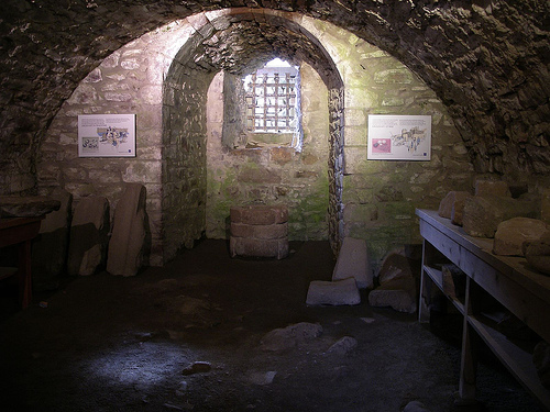
South of the tower, along the 14th-century
curtain wall (thick and buttressed), is a range of buildings: a central
great hall (about 24 by 15 meters/80 by 50 feet) with 3-meter-thick
(10-foot) walls, likely used for feasts and assemblies; northern private
apartments including a great chamber and solar for the lord; and
southern kitchens with vast fireplaces and service areas. Foundations in
the Nether Bailey's center suggest a chapel on a slight mound, with a
rectangular layout and possible altar remnants.
The gatehouse, on the
Nether Bailey's western side, comprises twin D-shaped towers flanking a
barrel-vaulted arched passage (3 meters/10 feet wide), defended by a
portcullis, double doors, and guardrooms. Rebuilt in phases, it included
upper rooms for the keeper and was blown up in 1692, leaving collapsed
masonry.
In the Upper Bailey, the southwestern rocky mound holds the
citadel or shell keep—an irregular rhomboid enclosure with
2.6-meter-thick (8.5-foot) walls of striated masonry, incorporating a
pentagonal tower projection, internal chambers, and a fireplace. This
13th-century structure overlays the vitrified fort. Opposite it, ruins
include a 16th-century doocot (pigeon house) base and 13th-century
building foundations (possibly an early hall, later a smithy). A
watergate in the eastern wall provides loch access, with adjacent
structures potentially for stables or storage.
Architectural
Styles and Evolution
Urquhart's architecture blends early medieval
fortification with later medieval castle elements, evolving from a
13th-century motte-and-bailey or shell keep design (unusual for
Scotland, differing from contemporaries like Kildrummy) to a
16th-century tower house complex. Initial 13th-century work under Alan
Durward featured the shell keep on the vitrified mound, thick curtain
walls, and basic enclosures. The 14th century saw strengthened defenses
amid MacDonald raids, including buttressed walls and embrasures. Royal
funds in the 15th century (e.g., 1437 and 1447) added buildings and
repairs.
The Grants' 16th-century remodels introduced Renaissance
influences: larger windows, bartizans, and domestic comforts in the
tower and ranges, shifting from pure defense to residence. Styles
include Romanesque arches in the gatehouse, Gothic elements in window
tracery, and defensive features like loops, embrasures, and garderobes
(one possibly a prison turret). By the 17th century, it was no longer a
primary residence, with repairs ceasing after 1676.
Materials and
Construction Techniques
Primarily constructed from local stone
(rubble with ashlar dressings for finer elements), the walls feature
striated masonry in early parts and vitrified stone (fused by intense
heat) from the prehistoric fort. Curtain walls vary in thickness (up to
2.7 meters/9 feet), with buttresses for support and lime mortar bonding.
Construction involved excavating the moat from bedrock, building on
uneven terrain with terracing, and incorporating defensive projections
like turrets. Later additions used skilled masonry for corbelling and
vaulting, with timber for roofs, floors, and drawbridges (now lost).
Notable Features and Historical Modifications
Standout elements
include the vitrified fort remnants, the watergate for boat access
(crucial for supply during sieges), the doocot for food production, and
the Grant Tower's panoramic views through west-facing windows.
Modifications reflect turbulent history: post-1296 English occupation
added defenses; 14th–15th-century raids prompted reinforcements;
Grant-era rebuilds (post-1509) enhanced habitability; and 1692
destruction focused on the gatehouse. Storms in 1715 and local stone
plundering accelerated decay. Excavations (1912 onward) uncovered
artifacts, and modern interventions include pathways and stabilization
for visitors.
Current State as Ruins
As ruins, Urquhart evokes
medieval grandeur with substantial walls, towers, and foundations
intact, though roofless and floorless. The Grant Tower remains climbable
via modern stairs, offering Loch Ness vistas. Historic Environment
Scotland maintains the site as a scheduled monument, with a visitor
center displaying artifacts like a trebuchet replica. It's a focal point
for Loch Ness tourism, blending history with natural beauty.