The Masaya volcano is located near the city of Masaya in the
department of Masaya, in Nicaragua, just 22 km south of the
country's capital, Managua.
It is one of the 7 active
volcanoes in the country. Its crater "Santiago" has an altitude of
635 m a.s.l. and continuously emits large amounts of sulfur dioxide
gas; it also maintains an incandescence inside due to a persistent
lava lake. The volcano forms the center of the Masaya Volcano
National Park and at its feet is the volcanic lagoon of the same
name. The park covers an area of 54 km2 that includes two volcanoes
and five craters and has more than 20 km of roads that can be
reached by car to the very edge of one of the craters; it was
created by executive decree on May 24, 1979. Among its facilities,
the volcanological museum stands out.
The chronicler Gonzalo Fernández de Oviedo observed the volcano in
1529 leaving the first written references of it. According to their
chronicles, the indians consulted a witch inside the volcano, so
Oviedo assumed that she was the devil himself.
The Spaniards
called the volcano "Boca del Infierno", so much so that in 1529,
Fray Francisco de Bobadilla, a mercedarian missionary from La Rioja,
planted a gigantic Cross to exorcise the devil on the top of the
main crater. It is the so-called "Cruz de Bobadilla" in memory of
the one who promoted and built the Convent of La Merced in León,
thus beginning a very intense evangelizing work that did not go
unnoticed and was soon named Provincial of the Mercedarians in the
Indies.
On April 13, 1538, a Palm Saturday, Fray Blas del
Castillo went down to the interior of the main crater of the Masaya
volcano, by means of pulleys, with a wooden cross to conjure evils,
and a hammer to chop the incandescent lava in search of the
so-called "gold of the volcano" because he believed that the lava
was melted gold, he even made excavations that failed.
On March 16, 1772, the Masaya erupted and spilled such a quantity of
lava that it threatened the homonymous city with a complete
extermination; to get rid of such a horrendous catastrophe, the
inhabitants of the locality took the image of the Virgin of the
Assumption in procession to the edge of the Masaya lagoon (located
between the city and the volcano) and then, according to eyewitness
testimony, the threatening current was diverted to the place known
as El Portillo.
The lava also threatened the town of Nindirí
whose inhabitants also took out the image of the Lord of Miracles in
procession; tradition has it that the Christ had the nail detached
from his right arm and where it fell the lava miraculously stopped
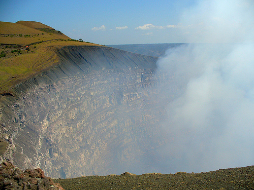
its advance so the eruption calmed down.6 In 1902 a new mouth was
opened in the form of a vent, which was widening and gave rise to a
vast crater of 500 meters in diameter and 300 meters deep, which
today is known as the Santiago crater. During the rainy season, it
is common for rain to seep into the volcano, causing it to emit
large amounts of acidic steam. In this way, a lagoon occupies the
eastern end of the caldera.
Sometimes, the Masaya emits large
concentrations of sulfur dioxide gases. In particular, sulfur
dioxide has been released from the Santiago Crater in large
quantities and volcanologists have studied these events to further
understand the impact of acid rain and its potential to cause health
problems. This acid rain affected the coffee plantations in the
Sierras of Managua.
The volcanic complex is composed of a nest of calderas and craters,
the Sierras being the largest of them. Within the latter lies the
Masaya volcano proper. This one houses the Masaya caldera, formed
about 2500 years ago by a basaltic eruption. Inside this caldera, a
new basaltic complex has grown from eruptions mainly in a
semicircular set of fumaroles that include the Nindirí and Masaya
cones.
The floor of the Masaya volcano is mainly covered with
lavas with poor vegetation, indicating new coatings in the last 1000
years, although only two lava flows have descended since the
sixteenth century. The first, in 1670, was due to an "overflow" of
the Nindirí crater, which at that time housed a lava lake 1 km in
diameter. The second, in 1772, was caused by a fissure in one of the
flanks of the Masaya cone that reached the area known as Piedra
Quemada.
In 1852 the craters Santiago were formed, which is
currently 635 meters high and emanates gases and San Pedro,
currently turned off.
It is included in the protected area known as "Masaya Volcano National Park", being the first site declared a national park in Nicaragua, on May 23, 1979, when the dictator Anastasio Somoza Debayle was President of the Republic (in the midst of the civil war between the National Guard and the Sandinista National Liberation Front FSLN), by Executive Decree No. 79 of May 23 of the same year and published in the Official Gazette No. 114 of the following day, May 24, Masaya became the first national park from Nicaragua, receiving the name of Masaya Volcano National Park.
Other eruptions have occurred in the last 50 years. On November 22,
1999, a new eruptive event began, a red dot appearing on satellite
images. On April 23, 2001 the crater exploded and formed a new
fumarole at the bottom of it. The explosion ejected rocks up to 6 dm
in length, which reached that they came to fall 500 m from the
crater. However, the material damage was minor and only one person
was injured, with no after-effects. On October 4, 2003 a cloud
caused by an eruption was reported, establishing its height at about
4.6 km approximately.
The Masaya volcano is located in the
department of Masaya, the smallest in Nicaragua and inhabited by
about 318,000 people (according to the 2005 Census).
In April
2012, the Santiago crater spewed incandescent material that caused a
fire in an area of 1.5 hectares and caused the closure of the
national park. A new fissure was detected in the crater through
which gases are emitted, as well as an increase in temperature and
gas emission. The Santiago crater of the Masaya volcano is one of
the 7 active volcanoes in Nicaragua in 2012 and 18 acts of activity
have been recorded since 1520, including the eruptions of 1772 and
1820. In 1965 it had the last act of relevant eruptive activity with
powerful explosions and large landslides in its surroundings.
It is one of the volcanoes whose crater rim is reachable by
helicopter only.
In 2014, the first episode of the Third
Season of "La isla: El reality", the Mexican version of the famous
reality show Survivor, was filmed there.
On March 4, 2020,
Nik Wallenda, an American acrobat, in just over thirty minutes
crossed on a cable the lava lake of the Santiago crater in the walk
that he considers the most dangerous of his career.