Location: Alberta Map
Area: 2,580 sq. mi (6,680 sq. km)
Elev. of Moraine Lake: 6,300 ft (1,920 m)
Park Visitor Center:
224 Banff Ave, Banff
Tel. (403) 762 8421
Banff National Park is located in the Canadian
Rocky Mountains, 120 km west of the city of Calgary, in the province
of Alberta. Its date of creation, 1885, makes it the oldest Canadian
national park. It has also been listed since 1985 (for the centenary
of its creation) as a UNESCO world heritage site with the other
parks of the Canadian Rocky Mountains.
Its 6,641 km2 of
mountainous terrain includes numerous glaciers and icefields, areas
of dense coniferous forests, and alpine-type landscapes. The park is
extended to the north by Jasper National Park. To the west lie Yoho
National Park, Kootenay National Park. The only major community in
the park is Banff, where the information center is located.
The construction of the Canadian Pacific Railway at the end of the
19th century played a decisive role in the economic development of
Banff. It was a little later, at the beginning of the 20th century,
that the construction of road links began bringing Banff closer to
the rest of the region. These roads, sometimes built by internment
camp prisoners, were part of the public works projects encouraged
during the Great Depression era to solve socio-economic problems.
Since the 1960s, the various facilities and infrastructures
available at the park have been open to the public throughout the
year, and the number of visitors has continued to increase,
exceeding 5 million in 1990 alone. In addition, millions other
travelers pass through the national park each year using the
Trans-Canada Highway.
But these exceptional figures, which
place Banff National Park among the most visited in the world, are
no less problematic from an environmental perspective. The high
intensity of tourist activities threatens the health of the park's
ecosystems. Parks Canada, the managing body of Canadian national
parks, reacted to this worrying situation by launching, in the
mid-1990s, a two-year study which ultimately made it possible to set
sustainable management objectives for the park, and to implement new
policies to preserve ecosystems.
In other words, the climate is general. July is always hot and has a temperature of around 22 °C. Il y a rarement de la neige à la hauteur de l'autoroute en été, mais les sommets des montagnes sont enneigés à l'année. In winter, the temperatures are extremely drastic. Janvier is always cold and has a temperature of around −15 °C. In winter, the snow is present to all the elevations and winter conditions are difficult to prepare. During the season, the temperature should drop to 1 °C at a temperature of 200 m.
Banff National Park was established in 1885, Banff
National Park is Canada's first national park, and its creation gave
birth to Canada's national park system. At 6,641 km², it is also one
of the largest national parks in Canada. The park sees visits well
into the millions annually.
1 Banff Information Centre, 224
Banff Av, ☎ +1 403-762-1550, fax: +1 403-762-3380, e-mail:
banff.vrc@pc.gc.ca. Banff. Hours: Winter (Jan 1 to May 17) 9AM-5PM;
Spring (May 18 to June 20) 9AM-7PM; Summer (June 21 to Sept 3)
8AM-8PM; Fall (Sept 4 to 19) 9AM-7PM; Winter (Sept 20 to May 16)
9AM-5PM. Closed December 25.
2 Lake Louise Visitor Centre, 201
Village Road (near Sampson Mall Lake Louise), ☎ +1 403-522-3833,
fax: +1 403-522-1212, e-mail: mailto:ll.info@pc.gc.ca. Winter
(January 1 to April 29) 9AM-4PM; Spring (April 30 to June 21)
9AM-5PM; Summer (June 22 to Sept 8) 9AM-8PM; Fall (Sept 9 to Sept
15) 9AM-7PM; Fall (Sept 16 to Sept 22) 9AM-5PM; Winter (Sept 23 to
April 30) 9AM-4PM. Closed Dec. 25.
Banff National Park
starts in the north at Sunwapta pass just south of the Columbia
Icefield and Jasper National Park with the southern park entrance
just north of Canmore. The town of Banff and the village and resort
of Lake Louise are within the park. The other park entrances are
from the east near the Saskatchewan River Crossing and from the west
at Kicking Horse Pass and Vermilion Pass.
A pass is required to stop in the park. Park employees carry out
regular checks, especially in summer. This pass is not necessary if
you are just passing through the park on the Trans-Canada Highway
without stopping. Entrance fees and user fees are used to fund park
facilities and visitor services. Entrance fees are daily, but an
annual pass, called a “discovery card”, is available. The Discovery
Card also provides access to 26 other national parks and 77
participating national historic sites. Note that the annual pass
becomes more advantageous than daily passes after only 7 days.
By car
Highway 1, which corresponds to the Trans-Canada
Highway, crosses the entire length of the park. The park is about an
hour and a half drive from Calgary, Alberta's largest city, and
about the same distance from Golden, British Columbia. It is also
possible to reach the park by car from Jasper via the Icefields
Parkway and from Red Deer via Highway 11. From British Columbia, it
can be reached via Highway 11. 93 which passes notably through
Cranbrook.
By bus
The following coach companies serve the
towns of Banff and Lake Louise with connections including to Calgary
and Vancouver.
Brewster
Greyhound
By train
VIA
Rail Canada – VIA Rail Canada is the only passenger train service
across Canada. It serves Banff and travels to Vancouver in the west
and Edmonton in the east.
Rocky Mountaineer Vacations– Offers
independent service along the scenic byway. Connections between
Vancouver or Whistler in British Columbia and Banff, Jasper and
Calgary.
By plane
The closest international airport to the
park is Calgary. Although Banff has an airstrip, there are no
commercial flights. To land directly in the park, you need a charter
flight; which is very expensive. Vancouver International Airport is
located about a 12-hour drive west of the park. Additionally,
Springbrank Airport located west of Calgary is approximately 80 km
away. The latter is served by small charter flights aboard small
planes. There is also a heliport in Cochrane a 5 minute drive east
of the park border and 15 minutes from the town of Banff.
There are different shuttles operating between the park and the
Calgary airport:
Banff Airporter – Several shuttles per day.
Brewster Banff Airport Express – Shuttle service from Calgary
Airport, Downtown Calgary, Edmonton Airport and West Edmonton Mall.
Note that service from Edmonton is via Jasper and in partnership
with Sun Dog Tours.
All visitors stopping in Banff National Park (even
just for gas) require a park permit. If you are driving through
non-stop, the pass is not required. Day passes and annual passes are
available.
All Canadian National Parks require visitors to
pay an entry fee. Your citizenship or place of residence does not
change what you pay; Canadian residents and international visitors
pay the same fees. The national parks in Alberta and BC are fairly
close to each other and it is possible to visit several of them in a
single day. If you pay an entry fee in one mountain park (e.g. Banff
National Park), and visit another on the same day (e.g. Yoho
National Park), you will not have to pay a second time. Your paid
entry fee is valid until 4PM the following day.
The fees that
visitors pay do not go to general government revenues; they are used
to enhance and maintain the parks and visitor services.
The
daily entry fees for 2018 are:
$9.80 for an adult (aged 18-64)
$8.30 for a senior (aged 65+)
free for children and youth (17 and
under)
$19.60 for a family/group (up to 7 people arriving in one
vehicle)
Parks Canada Passes
The Discovery Pass provides
unlimited admission for a full year at over 80 Parks Canada places
that typically charge a daily entrance fee It provides faster entry
and is valid for 12 months from date of purchase. Prices for 2018
(taxes included):
Family/group (up to 7 people in a vehicle):
$136.40
Children and youth (0-17): free
Adult (18-64): $67.70
Senior (65+): $57.90
The Cultural Access Pass: people who have
received their Canadian citizenship in the past year can qualify for
free entry to some sites.
Icefields Parkway – Connects Lake Louise in Banff National Park to
Jasper in Jasper National Park. You need to plan a whole day to travel
it in one direction. It is one of the most scenic drives in the world.
The road, which corresponds to Highway 93 northbound, covers 232 km from
the intersection of Highway 1 in Banff to the intersection of Highway 16
in Jasper. The route runs along the continental divide and crosses wild
and remote areas. It is renowned for its snow-capped peaks, turquoise
lakes, waterfalls and striking views of the Athabasca Glacier.
Promenade de la Vallée-de-la-Bow Logo indicating timetables Note that
from March 1, 2015, traffic by vehicle, bicycle or on foot on the 17 km
section of the promenade between the road interchange Trans-Canada
Highway and Canyon-Johnston camping is prohibited from March 1 to June
25 between 8 p.m. and 8 a.m. (the Trans-Canada Highway can be used to
avoid this section). – 48 km scenic secondary road which runs parallel
to the Trans-Canada Highway between Banff and Lake Louise. This section
of road crosses a mountainous area which includes several species of
large carnivores including wolves, cougars and bears.
Lake Minnewanka
Loop
Promenade des Lacs-Vermillion – 4.3 km panoramic route passable
all year round allowing you to observe wildlife and spectacular
landscapes. The walk is part of the Heritage Trail, a 26 km route.
Interpretive panels are present to explain the geology, the ecology of
wetlands and the human presence in this area.
Lake Louise – Emerald-toned glacial lake with a glacier in the
background. Ideal location for photography, waterside walks, boating and
horse riding. From November to June, do not go beyond the boathouse on
the left side of the lake to avoid the risk of avalanches.
Lake
Minnewanka (20 minutes north of Banff on the Lake Minnewanka loop.) –
The Nakodas (Stoneys) call this lake “water spirit lake”. Ideal place to
relax, picnic, dive, mountain bike, hike, cross-country ski or snowshoe.
Moraine Lake (near Lake Louise) – Located in the Valley of Ten Peaks.
Ideal place for hiking, boating and photography. The road is closed from
mid-October to mid-June.
Cave and Basin National Historic Site - The
birthplace of Canada's national parks system. A cavern discovered by
Canadian Pacific employees in 1883 from which thermal springs flow.
Programming offered all year round and interactive exhibition. The main
attraction is undoubtedly the visit to the underground cavern,
accessible by wheelchair, where the thermal waters bubble.
Banff Park
Museum National Historic Site of Canada – The Banff Park Museum presents
an original collection reflecting and interpreting the natural history
of Canada. The museum building itself dates from 1903.
Wildlife
Viewing – Banff National Park is ideal for photographers and wildlife
watchers. It is possible to see animals almost everywhere in the park.
However, there are some safety rules to respect (see the Respect section
below).
Birdwatching – Bring binoculars and a bird species
identification guide and go exploring. The park's reception and
information centers offer a checklist of the park's birds. More than 260
species have been recorded in the park. The best time of year for bird
watching is from spring to early summer and the best time of day is from
an hour before sunrise until 9 or 10 a.m. There are generally more birds
in the montane region and wetlands of the lower Bow Valley.
In summer
Canoeing – The park's mountain lakes and rivers are
ideal for canoeing and kayaking enthusiasts of all levels. Rowboats,
canoes, kayaks, sailboats and all other non-motorized boats are
permitted on all park lakes. Electric or gas powered boats are only
permitted on Lake Minnewanka. For its part, the Bow River which runs
through the park offers experienced paddlers excellent canoe trip
opportunities.
Cycling Logo indicating schedules The majority of
trails are accessible from May to October. – The park has 33 mountain
bike trails totaling 190 km of winding forest trails suitable for all
levels as well as along the lakes and along the peaks. The park also
offers plenty of road biking opportunities. The cycling season generally
runs from May to October.
Horseback riding – Horses are allowed in
most of the park with the exception of a few trails and areas where
natural resources are more fragile as well as certain trails reserved
for hiking. The maximum duration of a stay in a grazing area is three
consecutive nights and a single night in the special preservation zone
of the Siffleur River. Maximum group size is ten riders and two horses
per rider. It is requested to take as few pack animals as possible.
Horses must be prepared to encounter hikers and cyclists, to cross
rivers and to be put in hobbles.
Climbing / mountaineering
Boating
– Lake Minnewanka has a boat launch and trailer parking area. Electric
or gas powered boats are only permitted on this lake in the park.
Angling – A national park fishing license is required. However, young
people under the age of 16 do not need a permit if accompanied by a
permit holder aged 16 and over. Their sockets are added to those of the
holder. They can also purchase their own license and thus be entitled to
their own bag limit. You can purchase a daily fishing permit at a park
visitor center. Note that a permit purchased in Banff National Park is
also valid in other Rocky Mountain national parks. A summary of fishing
regulations updated annually will be given to you with your license.
Diving – Lake Minnewanka features the Minnewanka Landing site which has
been submerged and therefore offers a good diving opportunity. It is
obviously prohibited to remove or damage artifacts or elements of
historic structures in a national park.
Hiking Logo indicating
schedules The majority of trails are accessible from May to October
(maintained from mid-June to mid-October). – The park includes a large
network of trails maintained for all levels. Some go to mountain tops
and glacial lakes and observe wildlife. In total, the park has 64 trails
totaling more than 1,600 km. The most popular ones are easily accessible
from Banff or Lake Louise. The ideal season for hiking is from July to
mid-September.
Backpacking – 1,500 km of trails, 50 backcountry
campsites and two trail shelters. The best season for backpacking is
from mid-July to mid-September. In fact, several passages are still
snowy until the end of June. Even at lower elevations, trails tend to be
muddy in spring. With the exception of same-day return hikes, you must
have a backcountry access permit (Wilderness Pass) at a cost of C$9.8
(~€6.66 - price of 25 /01/2024) per person per night. In addition, a
reservation fee is required for all reservations at a cost of C$11.7
(~€7.95 - price of 01/25/2024). An annual backcountry access permit is
available at a cost of C$68.7 (~€46.7 - price as of 01/25/2024) giving
unlimited access to the parks' backcountry campsites mountain nationals
for the whole year. You still need to make a reservation even if you
have an annual permit. Groups cannot include more than ten people and
five tents. The maximum length of stay in a campsite is three
consecutive days. You can make your reservation by phone or in person at
the national park visitor center. A park access permit is required even
if you have a backcountry access permit. Wild camping is only permitted
in certain remote areas.
Ice climbing
Skating – It is possible to skate on a natural ice
surface on several lakes in the park. Note, however, that Parks Canada
does not indicate where it is safe to do this or where it is dangerous;
so you do so at your own risk.
Ice Diving – Minnewanka and Two Jack
Lakes are suitable for ice diving.
Snowshoeing – The ideal season for
snowshoeing is from late December to early April. Note, however, that
there are risks of avalanches from November to May. Trails designated
for winter excursions partly follow summer hiking trails, but not all
marked destinations are safe in winter.
Alpine skiing/snowboarding
Cross-country skiing The ski season extends from mid-November to the end
of April. – The ski season in Banff National Park is one of the longest
in North America. The park includes groomed trails and skating ski
trails. Around Lake Louise, conditions are optimal at the beginning and
end of the season, while in the rest of the park they are optimal from
mid-December to early April. The park produces a report on ski
conditions updated every week.
Nordic skiing
Stay on designated trails to avoid trampling vegetation and keep a good distance from animals. Avoid surrounding an animal, following it or obstructing its movement. Never put the life of a person, especially a child, in danger by photographing them with an animal. Avoid stalking or chasing an animal. Never follow an animal into bushes. Do not lure an animal with food or by simulating its cries. Wild animals feel stress when their space is occupied. Wild animals are always unpredictable and can be dangerous, especially females with their young and males defending their territory during mating season. If you observe defensive behavior from an animal, back away immediately. In general, you should keep a distance of 100 m from bears unless you are in a vehicle, 30 m from other large mammals and 200 m from the den of a coyote, fox or wolf . If you observe a bear growling or snapping its jaws, move back further or leave the area. You should also move back further if you observe a male elk or moose tilting its head and scratching the ground or if a female elk flattens its ears and looks you in the face while raising the hair on its rump. If an animal moves because of you, you are too close.
Banff National Park is located in western Alberta, bordering British
Columbia. It is surrounded by other national parks: Jasper National Park
to the north, Yoho National Park to the west, and Kootenay National Park
and Mount Assiniboine and Height of the Rockies provincial parks to the
south. Kananaskis Country and Canmore include Spray Valley and Peter
Lougheed Provincial Parks, Don Getty Wilderness Provincial Parks, Bow
Valley Provincial Parks, and Ghost River Wilderness Area which are
located south and east of Banff. To the northeast of the park are the
Siffleur and White Goat wilderness areas.
The Trans-Canada
Highway passes through Banff National Park, from Canmore in the east to
Yoho National Park, British Columbia, in the west, passing through Banff
and Lake Louise and the Horse Pass. -Street. The town of Banff is the
main commercial hub in the national park. The village of Lake Louise is
located at the junction of the Trans-Canada Highway and the Icefields
Parkway.
The north of the park is accessible by the Icefields
Parkway, a 230 km road linking Lake Louise to Jasper via the Bow Valley.
It then follows Mistaya Creek to Saskatchewan Crossing where it
intersects with David Thompson Road. It then follows the North
Saskatchewan River to the Columbia Icefield and the boundary of Jasper
National Park.
The Canadian Rockies are made up of several northwest/southeast
oriented ranges, the Rocky Mountain Foothills, the Front Ranges, the
Main Ranges and the Western Ranges. Closely following the Continental
Divide, the Main Ranges constitute the backbone of the Canadian Rockies.
Banff National Park extends eastward from the Continental Divide and
includes the eastern slopes of the Main Ranges and much of the Front
Ranges.
Banff's landscape is also marked by glacial erosion, with
deep U-shaped valleys and numerous hanging valleys that often end in
waterfalls. Pyramid-shaped mountains, such as Mount Assiniboine, were
shaped by glacial erosion. Many small gorges also exist, such as Mistaya
Canyon and Johnston Canyon. Elevation in the park ranges from 1,350 m in
the Bow Valley to 3,618 m at the summit of Mount Assiniboine.
The
western and northern limits of the park are demarcated by numerous
passes, the best known of which are the Cheval-qui-Rue (1,627 m),
Sunwapta (2,023 m), Vermilion (1,680 m) and Bow (2 088 m), which are
accessible by road and Howse Pass (1,539 m), an important historic pass
that was important during the fur trade.
The Canadian Rockies are composed of sedimentary rocks, shale,
sandstone, limestone and quartzite, whose origin is the deposition of
sediments in an inland sea. The geological formations of the Banff
Mountains are dated between the Precambrian and the Jurassic. The
mountains were formed 80 and 120 million years ago by overlapping. Over
the past 80 million years, erosion has greatly shaped the landscapes,
with erosion more intense in the foothills and front ranges than in the
main ranges. The mountains around Banff feature a variety of landscapes
depending on the composition of the rock deposits, the orientation of
the layers and their structure.
Many Banff Mountains are made up
of sedimentary layers that dip 50 to 60 degrees. Such mountains have a
steep side and a more gradual slope that follows the stratification of
rock formations such as Mount Rundle, near Banff. The mountains of Banff
National Park also have other types of structure: complex, irregular,
anticline, syncline, crenellated, serrated and sawback.
Castle
Mountain has a crenellated shape, with steep slopes and cliffs. Its
upper section is composed of a layer of Paleozoic shale between two
layers of limestone. Jagged mountains like Mount Louis feature sharp,
jagged peaks. The Sawback Range, made up of tilted sedimentary layers,
has been eroded through gullies. Talus deposits are common at the foot
of mountains and cliffs.
Banff is entirely contained within the Nelson watershed, which flows
into Hudson Bay. The main rivers in the park are the Bow, which flows to
the south and west of the park, and the North Saskatchewan, to the north
of it. The park's backcountry also hosts the headwaters of the Red Deer
and Clearwater.
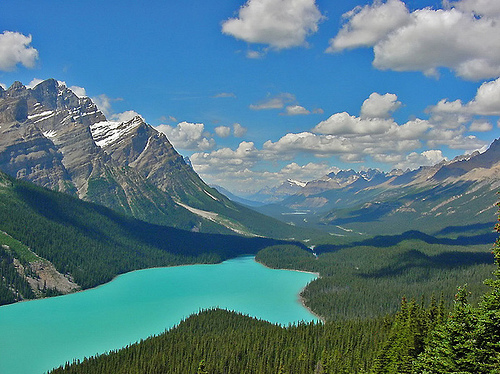
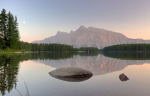
The park includes numerous lakes, the most
accessible of which are Bow, Hector, Louise, Moraine, Minnewanka and
Peyto lakes.
Banff National Park has many large glaciers and ice fields, many of
which are easily accessible from the Icefields Parkway. In the main
ranges, small cirque glaciers are common, located in depressions on the
flanks of many mountains.
As with the majority of mountain
glaciers around the world, glaciers are retreating in Banff. The
photographs clearly bear witness to these retreats and the trend has
become alarming enough for glaciologists to begin research on the park's
glaciers in more depth and analyze the impact that the reduction in the
thickness of the ice and the water coming from it Melting snow could
affect the supply of streams and rivers.
Glacier areas include
the Waputik Icefield and Wapta Icefield, both of which are on the border
between Banff and Yoho National Parks. The Wapta Icefield covers
approximately 80 km2. The Peyto, Bow and Vulture glaciers are part of
the Wapta Icefield, included in Banff National Park. Bow Glacier
retreated an estimated 1,100 m between the 1850s and 1953. Since that
time, it has retreated further, forming a new lake at the end of the
frontal moraine. The Peyto Glacier has retreated approximately 2,000 m
since 1880 and is at risk of disappearing entirely in the next 30 to 40
years. Crowfoot and Hector Glaciers are independent glaciers and are not
affiliated with the major ice fields. They are easily visible from the
Icefields Parkway.
The Columbia Icefield, far north of Banff, is
on the border between Banff and Jasper National Parks and extends into
British Columbia. Snow Dome, in the Columbia Icefield, constitutes a
hydrological peak of North America, the water flowing from this point
goes to the Pacific through British Columbia, towards the Arctic Ocean
via the Athabasca River, and into Hudson Bay and finally into the
Atlantic Ocean, via the Saskatchewan River. The Saskatchewan Glacier,
which is approximately 13 km in length and 30 km2 in area, is the main
glacier of the Columbia Icefield. Between the years 1893 and 1953, the
Saskatchewan Glacier retreated 1,364 m, with an average of 55 m per year
between 1948 and 1953.
Overall, glaciers in the Canadian Rockies
lost 25% of their mass during the 20th century.
The town of Banff, founded in 1883, is the main commercial center of
Banff National Park, as well as a hub of cultural activity. Banff is
home to several cultural institutions including the Banff Park Museum
National Historic Site, the Whyte Museum, the Luxton Museum, the Banff
Cultural Centre, the Cave and Basin National Historic Site and several
art galleries. Throughout its history, Banff has hosted many annual
events including Banff Indian Days since 1889 and the Banff Winter
Carnival since 1976. Since that same year, the cultural center has
hosted the Banff Mountain Film Festival. The Bow River crosses the city
and offers the spectacle of Bow Falls at the exit of the city.
In
1990, the Town of Banff incorporated as a municipal corporation of
Alberta but is still subject to the National Parks Act and federal
authority over planning and development. According to the 2007 census,
the Town of Banff has a population of 8,720, of which approximately
7,437 are permanent residents.
Lake Louise, a village located 54
km west of Banff, is the site of the historic Château Lake Louise on the
shores of Lake Louise. The Lake Louise Ski Resort is also located near
the village. Located 15 km from Lake Louise, Moraine Lake offers
panoramic views of the Valley of the Ten Peaks. This scene is reproduced
on the back of Canadian $20 bank notes from the years 1969-1979 (“Scenes
from Canada” series).
Banff National Park operates in a particular climate, where the need
for conservation and the interests of development are constantly in
conflict. James Hector of the Palliser expedition in 1859 was the first
to report these thermal springs which would later serve as the pretext
for the creation of the park. In 1883, they were rediscovered by three
workers working for the Canadian Pacific Railway. They, as well as other
applicants, then dispute the ownership rights of the sources. A
government tribunal investigation followed and the Government of Canada,
led by Prime Minister John A. Macdonald, decided to transform the 26 km2
encompassing all the thermal mineral springs into a reserve.
It
was therefore to remedy these tensions that Prime Minister Macdonald
erected a small protected zone around the site, subsequently extended to
the regions of Lake Louise and the Columbia Icefield. This ice field,
with an area of 325 km2, is made up of around thirty distinct glaciers
and its meltwater feeds the hydrographic networks of the North
Saskatchewan and Athabasca rivers, and the Columbia and Fraser rivers,
thus flowing into the oceans. Pacific, Arctic and Atlantic.
Archaeological research carried out around the Vermilion Lakes dates
the first human activities in Banff to 10,300 B.P. (year -8,300).
Indeed, long before the arrival of Europeans, aboriginal peoples such as
the Stoneys, Kootenays, Tsuu T'ina, Kainai, Peigans, or Siksika, already
lived in the region, where they practiced hunting for buffalo and other
animals. other game.
Once British Columbia was ceded to Canada on
July 20, 1871, the authorities gave the green light for the construction
of a transcontinental railway, which began four years later, in 1875.
The Cheval-qui-Rue pass was chosen , to the detriment of the Tête Jaune
pass located further north, as a crossing point for the Rocky Mountains.
Ten years later, the final section was laid in Craigellachie, British
Columbia.
It was therefore a dispute surrounding the Banff hot springs that
led, on November 25, 1885, Prime Minister John A. Macdonald to establish
the Banff Hot Springs reserve. Two years later, on June 23, 1887, the
law creating the Rocky Mountain Parks was enacted. The 26 km2 reserve
was then extended to reach 674 km2, and took the name Rocky Mountains
Park. It was the birth of the first Canadian national park, the second
established in North America after Yellowstone National Park in the
United States.
At the same time, the Canadian Pacific Railway
built the Banff Springs Hotel and the Château Lake Louise to attract
tourists and increase ridership on the line. Banff became a popular
destination for wealthy tourists arriving from Europe on luxury
transatlantic liners and continuing west by train. It is the same for
the rich American bourgeois.
Some visitors participate in
mountain-related activities offered in Banff, including using local
guides. Brothers Jim and Bill Brewster, who are among the youngest in
the field, and Tom Wilson guide tourists to the fishing grounds. The
Alpine Club of Canada, established in 1906, organizes mountaineering
excursions and backcountry camps.
In 1911, Banff became
accessible by car from Calgary. From 1916, the Brewster brothers'
company offered coach excursions. In 1920, access to Lake Louise by road
was finally possible, and the Banff-Windermere Highway opened in 1923
and linked Banff to British Columbia.
In 1902, the park was
expanded to cover 11,400 km2, encompassing areas around Lake Louise, the
Bow River, the Red Deer River, Kananaskis and the Spray River. However,
in 1911, yielding to pressure from livestock and logging, the size of
the park was reduced to 4,663 km2. The boundaries of the park changed
several times until 1930, the size of the park was then fixed at 6,697
km2, with the adoption of the National Parks Act. The law also renamed
the park Banff National Park, named after the Canadian Pacific railway
station which itself took its name from Banffshire, a region of
Scotland.
In 1933, Alberta gave 0.84 km2 to the park. After
further minor changes in 1949, the park covers 6,641 km2.
In 1887, indigenous tribes signed Treaty No. 7, which gave Canada the rights to explore the territory to learn about its resources. In the early 20th century, coal was mined near Lake Minnewanka in Banff. For a brief period, an anthracite mine operated, but was closed in 1904. The Bankhead mine, on Cascade Mountain, was operated by the Canadian Pacific Railway from 1903 to 1922. In 1926, the town was dismantled, many buildings were moved to other towns, particularly Banff.
During the First World War, immigrants from Austria, Hungary, Germany
and Ukraine were sent to Banff to work in internment camps. The main
camp is located at Castle Mountain, then moves to Cave and Basin during
the winter. Many infrastructures and roads were built by these Canadian
internees of Slavic origin.
During World War II, internment camps
were once again set up in Banff, with camps set up at Lake Louise,
Stoney Creek, and Healy Creek. The prisoners are, in large part,
Mennonites from Saskatchewan. The Japanese were not interned in Banff
during the Second World War, but rather in Jasper National Park, where
detainees worked on the Yellowhead Highway and other projects.
In 1931, the Government of Canada enacted the Unemployment and Farm
Relief Act to revive the economy during the Great Depression. Major
public works projects are organized in national parks. In Banff, workers
are building a new pool and baths for the Upper Hot Springs spa complex,
complementing Cave and Basin. Other projects include road construction
in the park, work around the town of Banff, and the construction of a
highway linking Banff to Jasper. In 1934, the Construction Projects Act
was passed, providing continued funding for public works projects. New
projects include the construction of an administrative building in
Banff.
In 1940, the Icefields Parkway reached the Columbia
Icefields in the Banff region, and connected Banff to Jasper.
Winter sports activities began in Banff in February 1917, with the
first Banff Winter Carnival. A large ice palace, built by camp
internees, was the star of the 1917 carnival.
During the
carnival, sporting events are organized: cross-country skiing, ski
jumping, curling, snowshoeing and skijoring. In the 1930s, the first
alpine ski resort, Sunshine Village, was established by Brewsters. On
Mount Norquay, a ski area was also created during the 1930s, the first
chairlift was installed in 1948.
In the 1960s, the Trans-Canada
Highway was built, providing a new roadway in the Bow Valley,
complementing the Bow Valley Parkway, making the park more accessible.
Also in the 1960s, the Calgary International Airport was built. Since
1968, when the Fairmont Banff Springs Hotel was converted to accommodate
winter guests, Banff has been frequented by tourists throughout the
year.
Canada has applied several times to host the Winter
Olympics, offering the Banff site. The first time in 1964, but the
Olympic committee chose Innsbruck, Austria. A second attempt was made in
1968, but the Winter Games were awarded to Grenoble in France. Once
again, Banff bid for the 1972 Winter Olympics, with plans to host them
in Lake Louise. This application is the most controversial by
environmental pressure groups, because it is sponsored by Imperial.
Yielding to pressure, Jean Chrétien, then Minister of the Environment
and minister responsible for Parks Canada, withdrew the application.
When Canada finally hosted the 1988 Winter Olympics in Calgary, the
cross-country skiing events were held at the Canmore Nordic Center
Provincial Park in Canmore, Alberta, located on the eastern edge of
Banff National Park.
Since the Rocky Mountain National Parks Act, subsequent laws and
implemented policies have placed greater emphasis on preservation.
Public opinion is now very aware of environmental protection. Parks
Canada has followed new policies in this direction since 1979. The
National Parks Act was amended in 1988 and made the preservation of
ecological integrity the absolute priority of all park management
decisions. Furthermore, the law requires each park to produce a
management plan including greater public participation.
In 1984,
Banff Park was listed as a UNESCO World Heritage Site, along with the
other national and provincial parks that form the Canadian Rocky
Mountain Parks. For its mountain landscapes featuring remarkable peaks,
glaciers, lakes, waterfalls, canyons and limestone caves, but also for
the fossils found here. With this inscription, new obligations for
preservation were added.
During the 1980s, Parks Canada
privatized park services such as golf courses, and raised fees for the
use of other facilities and services to compensate for budget
restrictions.
In 1990, the Town of Banff incorporated itself as a
municipal corporation to allow local residents to have a say in any
development proposals. In the same years, park development plans,
including the expansion of Sunshine Village, were challenged by lawsuits
brought by the Canadian Parks and Wilderness Society (CPAWS). In the
mid-1990s, the Banff-Bow Valley Study was launched to find ways to
better address environmental concerns and park development issues.
Banff National Park is entirely within the Northwest Forested Mountains ecological region. It is also entirely within the Western Cordillera Level II ecological region and the Canadian Rockies Level III ecological region.
Banff National Park has three layers: mountain, subalpine and alpine.
The mountain level, which makes up 3% of the park, is located between
1,350 and 1,500 m. The forests of dry areas are mainly composed of
Douglas fir (Pseudotsuga menziesii), trembling aspen (Populus
tremuloides), lodgepole pine (Pinus contorta), all accompanied by
grasses. The wettest areas are composed of white spruce (Picea glauca),
balsam poplar (Populus balsamifera) and shrub meadows. The mountainous
areas, which tend to be the favorite habitat of wildlife, have undergone
significant development of human activities over the years.
The
subalpine stage, consisting mainly of dense forests, makes up 53% of the
Banff region. It is divided into two levels: the lower subalpine and the
upper subalpine. The forests of Engelmann spruce (Picea engelmannii) and
lodgepole pine and subalpine fir (Abies lasiocarpa) make up the lower
part which is located between 1,500 and 2,000 m. The upper part (between
2,000 and 2,300 m) is composed of Englemann spruce, subalpine fir and is
dotted with meadows of dwarf shrubs in the avalanche paths. The park is
sometimes infested by the mountain pine beetle, an insect native to the
Rockies, which attacks old lodgepole pines. The park conducts prescribed
burns in an effort to reduce the spread of the infestation and
regenerate the pine forests.
44% of the park is located above the
tree line (located at approximately 2,300 m above sea level), in the
alpine level. This level has some alpine meadows, but also bare rock,
snow and glaciers.
The representative animals of the park are the elk (Cervus
canadensis), the moose (Alces alces), the mountain goat (Oreamnos
americanus), the Canadian mouflon (Ovis canadensis), the black bear
(Ursus americanus), the Grizzly ( Ursus arctos horibilis) and caribou
(Rangifer tarandus). 56 species of mammals have been recorded in the
park. Grizzlies and black bears live in wooded areas. The cougar (Puma
concolor), the Canada lynx (Lynx canadensis), the wolverine (Gulo gulo),
the weasel (Mustela sp.), the river otter (Lontra canadensis) and the
wolf (Canis lupus) are the main mammals predators. Elk, mule deer
(Odocoileus hemionus) and white-tailed deer (Odocoileus virginianus) are
common in the park's valleys, including around (and sometimes in) the
town of Banff, while moose tend to be more discreet, remaining mainly in
wet areas and near watercourses.
The Mountain Goat, the Canadian
Mouflon, the Rocky Mountain Marmot (Marmota caligata) and the American
Pika (Ochotona princeps) are very widespread in the Alpine region. The
Canadian beaver (Castor canadensis), the American porcupine (Erethizon
dorsatum), the red squirrel (Tamiasciurus hudsonicus), the lesser
chipmunk (Tamias minimus) and the chipmunk (Tamias amoenus) are the
small mammals more commonly observed. In 2005, only 5 caribou were
recorded in the park, making them one of the rarest mammal species in
the park.
Due to the harsh winters, few reptiles and amphibians
live in the park. A single species of toad, three species of frogs, a
single species of salamander and two species of snakes have been
identified there.
At least 280 species of birds are present in
Banff, including predators such as the Bald Eagle (Haliaeetus
leucocephalus), the Golden Eagle (Aquila chrysaetos), the Red-tailed
Hawk (Buteo jamaicensis), the Osprey (Pandion haliaetus), and various
species of falcons, including the Merlin (Falco columbarius). Common
species such as the Canada Chickadee (Perisoreus canadensis), the
Black-backed Woodpecker (Picoides dorsalis), the Mountain Bluebird
(Sialia currucoides), the American Nutcracker (Nucifraga columbiana),
the Gambel's Chickadee (Poecile gambeli) and The White Pipit (Anthus
spinoletta) is frequently found in low altitude areas. The White-tailed
Ptarmigan (Lagopus leucura) is a ground-feeding bird that is often seen
in alpine areas. The rivers and lakes are frequented by around a hundred
different species, including the common loon (Gavia immer), the heron
and the mallard (Anas platyrhynchos) which spend the summer in the park.
A variety of snail, the Banff Springs Snail (Physella johnsoni),
which is found in only seven thermal springs in Banff, is reported as an
endangered species. The woodland caribou, found in Banff, and the
grizzly bear have vulnerable species status.
Banff National Park is Alberta's busiest tourist destination and one
of the most visited national parks in North America, with 3,226,978
visitors in 2011-2012. In summer, 42% of park visitors come from Canada
(23% from Alberta), while 35% come from the United States and 20% from
Europe. Tourism represents $6 billion for Canada's economy. A pass is
required to stop in the park and checks are frequent during the summer
months, particularly at Lake Louise and the Icefields Parkway start.
This permit is not necessary to cross the park without stopping, like
the approximately 5 million people who use the Trans-Canada Highway each
year.
Many activities are possible in the park; the Upper Hot
Springs Hot Springs, a 27-hole golf course at the Fairmont Banff Springs
Hotel, and three ski resorts Sunshine Village, Lake Louise, and Mount
Norquay. A network of trails allows for numerous hikes, which can last
several days. Other activities are possible in summer and winter
(camping, climbing, horse riding, skiing, Nordic skiing). Use of
campgrounds, Alpine Club of Canada huts, or other facilities requires a
backcountry permit. A reservation for a campsite is also recommended.
Banff National Park is managed by Parks Canada, under the National
Parks Act passed in 1930. For the 2011-2012 fiscal year, the agency has
a budget of $696 million to manage 42 national parks, 956 national
historic sites — including 167 managed directly by the agency — and four
national marine conservation areas. Over time, park management policies
have prioritized environmental protection over development.
In
1964, a policy statement reaffirmed the conservation ideals outlined in
the 1930 Act. With the controversial 1972 bid for the Winter Olympics,
environmental groups became more influential, prompting Parks Canada to
withdraw its support for this candidacy. In 1988, the National Parks Act
was amended, defining as a priority the maintenance of ecological
integrity. The amendment also allowed non-governmental organizations to
sue Parks Canada for violations of the Act. In 1994, Parks Canada
established the Operating Principles and Policies, which provided a
mandate for the Bow Valley Study Group to develop management
recommendations. As with other national parks, Banff is required to have
a park management plan.
On a provincial level, the park area and
included communities (other than the Town of Banff which is a Municipal
Corporation) are administered by the federal minister responsible for
Parks Canada as Improvement District No. 9 (Banff).
Human impact
As early as the 19th century, humans impacted the ecology of Banff
through the introduction of non-native species, control over other
species, development in the Bow Valley, and other human activities.
The Trans-Canada Highway is problematic due to road traffic which
poses risks to wildlife and is an obstacle to wildlife migration. The
grizzly bear is one of the species most affected by the highway as well
as all other developments that cause landscape fragmentation. Eco-ducts,
a series of tunnels, two wildlife crossings have been constructed at a
number of points along the Trans-Canada Highway to alleviate this
problem.
Bison once lived in the Banff Valleys and were hunted by
indigenous people. The last bison was killed in 1858. Elk are not native
to Banff but were introduced from Yellowstone National Park in 1917 with
57 elk. The introduction of moose to Banff, combined with controls on
coyotes and wolves by Parks Canada in the early 1930s, caused an
imbalance in the ecosystem. Other species that have been displaced from
the Bow Valley include the grizzly bear, cougar, lynx, wolverine, otter
and moose.
Beginning in 1985, gray wolves recolonized areas of
the Bow Valley. However, the wolf population is having difficulty
establishing itself, with 32 wolves having been killed along the
Trans-Canada Highway between 1987 and 2000, leaving only 31 wolves in
the region.
The population of Bull Trout (Salvelinus confluentus)
and other fish species native to Banff Lakes has also declined following
the introduction of non-native species such as Brook Trout (Salvelinus
fontinalis) and Trout. rainbow (Oncorhynchus mykiss). Lake trout
(Salvelinus namaycush), cutthroat trout (Oncorhynchus clarki) and
sharpmouth (Acrocheilus alutaceus) are also native species that are
becoming rare, while Chinook salmon (Oncorhynchus tshawytscha), white
sturgeon (Acipenser transmontanus), Pacific lamprey (Lampetra
tridentata) and Banff rapids dace (Rhinichthys cataractae smithi) are
probably locally extinct. The Banff Rapids Dace, a subspecies endemic to
Banff, is now an extinct subspecies.
Parks Canada management has been organizing firefighting since Banff National Park was created. Since the early 1980s, Parks Canada has adopted a fire-burning strategy, which helps limit the catastrophic effects of fires.
In 1978, the Sunshine Village ski resort expansion was approved. It
provides for the addition of parking, the extension of the hotel and the
development of the Goat's Eye Mountain. The implementation of this
development project was delayed in the 1980s, while an environmental
impact assessment was carried out. In 1989, Sunshine Village withdrew
its expansion proposal, in light of government reservations, and
presented a revised project in 1992. This new plan was approved by the
government, pending an environmental assessment.
Subsequently,
the Canadian Parks and Wilderness Society (CPAWS) took legal action in
court which suspended the development. CPAWS is also lobbying UNESCO to
have Banff Park's World Heritage listing revoked because of the risks
this development poses to the ecological health of the park.
Although the National Parks Act and the 1988 Amendment emphasize
ecological integrity, in practice Banff Park suffers from
inconsistencies in policy application. In 1994, the Bow Valley Study
Group was charged by Sheila Copps, the minister responsible for Parks
Canada, with providing recommendations on how to best manage human use
and development and maintain the ecological integrity.
During the
two years that the Bow Valley Study Group worked, development projects
were halted, including the expansion of the Sunshine Village ski resort
and the widening of the Trans-Canada Highway between Castle Junction and
Sunshine. The group released more than 500 recommendations, such as
limiting the growth of the Town of Banff, capping the population at
10,000, putting an attendance quota on popular hiking trails and
reducing development in the park.
Another recommendation calls
for fencing the town to reduce encounters between humans and elk. This
measure also aims to reduce access to the city for elk who come to take
refuge there to escape predators, such as wolves who tend to avoid the
city.
When the report was released, Sheila Copps immediately
accepted the proposal to cap the city's population. In response to
concerns and recommendations raised by the Bow Valley Study Group, a
number of development plans were scaled back in the 1990s. Plans to add
nine holes to Banff Springs Golf were abandoned in 1996.
With the Town of Banff restricted in its growth, Canmore, located
just outside the boundaries of Banff Park, is growing rapidly to meet
increasing tourist demand.
One of Canmore's major development
proposals concerns the Three Sisters Golf Course, proposed in 1992,
which has been the subject of controversial debate. With environmental
groups arguing that development would cause significant fragmentation of
biological corridors in the Bow Valley,