Location: Newfoundland Map
Area: 1,805 km2 (697 sq mi)
Official site
Gros Morne National Park is a Canadian park
located on the west coast of the island of Newfoundland in the
province of Newfoundland and Labrador, approximately 700 km west of
Saint John. It is named after Gros Morne, the second highest peak of
the island. Covering an area of 1,805 km2, Gros Morne National
Park particularly renowned for the richness of its geology. It has a
portion of the ocean floor of the ancient Iapetus Ocean and the
exposed terrestrial mantle, making it a good example of plate
tectonics. It is also known for the beauty of its glacial valleys,
including that of Western Brook Pond.
Inhabited by various
tribes for more than 5,000 years, the area of Gros Morne National
Park was also one of the first regions of the Americas frequented by
Europeans, first by the Vikings in the 10th century and then by
Basque, French and English fishermen. Long disputed, the Gros Morne
region became English in the early eighteenth century, but the
French retained rights to fish and fish drying. It was finally
inhabited, from the beginning of the nineteenth century, by a
population practicing fishing as well as logging. Gros Morne
National Park was created in 1973 as a result of a
federal-provincial agreement, which was formalized on October 1,
2005. It was recognized as a UNESCO World Heritage Site in 1987. The
park is visited by approximately 170,000 visitors per year and is
administered by Parks Canada Agency.
A UNESCO World Heritage site, Gros Morne National
Park protects an area of impressive natural beauty, rural
Newfoundland culture, and unique geological wonders. The park's
namesake mountain, Gros Morne, is the second highest point in
Newfoundland at 806 metres. Its French meaning is "large mountain
standing alone," or more literally "great sombre."
It covers
an an area of 1,805 km² (697 sq mi).
Gros Morne is a member
of the Long Range Mountains, an outlying range of the Appalachian
Mountains, stretching the length of the island's west coast. It is
the eroded remnants of a mountain range formed 1.2 billion years
ago.
The park's operating season is from mid-May to
mid-October: most facilities are open seven days a week, including
holidays. This is the high season, so you should book your
accommodation well in advance. The park is open in winter with some
activities available in winter. All major travel routes are
maintained throughout the year, although temporary closures or
warnings may come into effect in the event of adverse weather
conditions.
Visitor Centre, Rocky Harbour, ☎ +1 709 458-2417,
e-mail:
grosmorne.info@pc.gc.ca
These numbers were updated in 2018.
Daily
fees
May 16-Oct 31. Adults $9.80, seniors $8.30, families $19.60,
children under 18 free.
Nov 1-May 25. Adults $7.80, seniors
$6.80, families $15.70, children under 18 free.
Annual passes.
Adults $49.00, seniors $41.70, families $98.10, children under 18
free.
Wilderness hiking fees. Long range reservation fee $24.50,
Long Range hike $83.40 per person, North Rim hike $68.70 per person,
combined Long Range and North Rim hike $122.60 per person.
Parks
Canada Passes
The Discovery Pass provides unlimited admission
for a full year at over 80 Parks Canada places that typically charge
a daily entrance fee It provides faster entry and is valid for 12
months from date of purchase. Prices for 2018 (taxes included):
Family/group (up to 7 people in a vehicle): $136.40
Children
and youth (0-17): free
Adult (18-64): $67.70
Senior (65+):
$57.90
The Cultural Access Pass: people who have received their
Canadian citizenship in the past year can qualify for free entry to
some sites.
Gros Morne is an 1,805 km2 park located in the western island of
Newfoundland, approximately 700 km west of Saint John and 120 km north
of Corner Brook. The park is located in the Long Range Mountains and on
either side of Bonne Bay.
Although this park is located entirely
in the unorganized territories of Divisions No. 9 and No. 5, it encloses
several municipalities, namely Trout River, Woody Point,
Glenburnie-Birchy Head-Shoal Brook, Norris Point, Rocky Harbour, Sally's
Cove, St .Pauls and Cow Head. The population of these eight communities
is approximately 4,000 people.
The oldest rocks in Gros Morne were formed 1.2 billion years ago.
They are mainly composed of granite and gneiss coming from the collision
between two continents. These deposits formed the current plateau of the
Long Range Mountains.
At the end of the Precambrian, 570 million
years ago, the opening of the Iapetus Ocean generated numerous dykes
visible from Western Brook and Ten Mile Ponds. During the following 200
million years, in the Cambrian and Ordovician, the continent of
Laurentia and the Gros Morne area underwent intense erosion. At the
beginning, these are composed mainly of sand, including the quartzite of
Gros Morne. The region is then occupied by a tropical sea, which favors
the formation of carbonate banks, which form thick deposits of limestone
and dolomite. Marine currents and earthquakes cause the detachment of
part of these sediments from the continental shelf which are found at
the bottom of the continental slope and form limestone breccias through
the shales.
500 million years ago, the Iapetus Ocean began to
close. During the collision of the continents, part of the oceanic crust
of the Iapetus Ocean is trapped in the neighboring continental plate,
giving rise to ophiolites. This intrusion is responsible for the
formation of the Tablelands, one of the few places where a cross section
of the oceanic crust, the Mohorovicic discontinuity and the Earth's
mantle can be seen. The main rocks found are peridotite, dunite,
diabase, gabbro and basalt. This phenomenon ends 475 million years ago.
The most recent sediments are green sandstones, breccias and shales.
During the Devonian, the formation of the Appalachians caused the
general uplift of the region. This then remains geologically stable,
only subject to erosion. The glaciations of the last two million years
give the park its current appearance.
Green Point, which is
located 12 km north of Rocky Harbor, has been recognized as a global
stratotypic point to distinguish the separation between the Cambrian and
Ordovician.
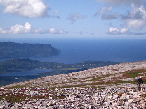
The relief of the Gros-Morne region is characterized by the presence of two plateaus separated by Bonne Baie. The highest northern plateau includes Gros Morne (806 m) and Big Level (795 m). This plateau is intersected by impressive glacial valleys occupied by Ten Mile Ponds, Baker Brook and Western Brook, the cliffs of the latter reaching 670 m. The smaller plateau south of Bonne Baie includes the Tablelands (721 m). Northwest of Bonne Baie, between Rocky Harbor and Cow Head, there is a low-lying coastal plain five kilometers wide.
Gros Morne Park includes 284 km of marine coastline. The coast is cut by two deep bays, Bonne Baie and St. Pauls Bay. The park is crossed by three rivers, the Trout, the Lomond and the St. Pauls as well as numerous streams. The park has numerous bodies of water, called ponds (Pond). The main ones are Trout River, Ten Mile, Baker Brook and Western Brook ponds.
The climate of the park is cool, with a maritime climate, due to its proximity to the sea. The lands located at higher altitudes are characterized by a subarctic climate. The average annual temperature is 3°C, with July at 15.4°C and February at −8.9°C. The park's annual precipitation is 1,316.5 mm including 418 cm of snow. Finally, fog is present from 10 to 30 days per year.
According to the Commission for Environmental Cooperation, the park is located in the Newfoundland Island of the Northern Forests Level III ecoregion. Canada, in terms of its ecological framework, divides the island of Newfoundland into several ecoregions, three of which are within the park. The first, southwest Newfoundland, includes the shores of Bonne Baie and the south of the park. It is characterized by a mild climate compared to the rest of the island and dense balsam fir forests. The Long Range region is characterized by ericaceous heath and a much cooler climate. It includes the peaks of the park. The final region, the Northern Peninsula, includes the coast north of Bonne Bay. It is occupied by balsam fir and black spruce forests.
Gros Morne Park contains 711 species of vascular plants, 401 species
of bryophytes (mosses and liverworts) and 400 species of lichens, which
represents 60% of the flora present on the island. The park's coasts are
composed mainly of white spruce (Picea glauca) and balsam fir (Abies
balsamea). The coastal plain includes numerous sphagnum bogs accompanied
by alder (Alnus sp.) and sedge marshes accompanied by tamarack (Larix
laricina). The moist soils are populated with black spruce (Picea
mariana) and the forests with drier soils are populated with balsam fir.
From an altitude of 500 m, the forest gives way to alpine tundra.
This is made up of stands of diapensia (Diapensia lapponica), crowberry
(Empetrum sp.), Alpine bearberry (Arctostaphylos alpina), moss and
lichens. The Serpentine of the Tablelands gives the mountain floor a
desolate appearance covered in mosses and rare plants that are adapted
to the particular soil chemistry. There are 100 taxa considered rare in
Gros-Morne, including the Quelpart teafly (Thelypteris Quelpaertensis),
a species of fern whose population in Gros-Morne is the only one east of
the Rockies.
The island of Newfoundland is relatively poor in mammals, with only
14 native species. Over the past 400 years, twelve other species have
been introduced by humans. The ungulates found in the park are the
woodland caribou (Rangifer tarandus caribou) and the moose (Alces
americanus). Carnivores are represented by the black bear (Ursus
americanus), the red fox (Vulpes vulpes), the ermine (Mustela erminea)
and the American mink (Neovison vison). Small mammals are represented by
the gray shrew (Sorex cinereus), the arctic hare (Lepus arcticus), the
snowshoe hare (Lepus americanus), the American red squirrel
(Tamiasciurus hudsonicus), the Canadian beaver ( Castor canadensis), the
deer mouse (Peromyscus maniculatus), the meadow vole (Microtus
pennsylvanicus) and the muskrat (Ondrata zibethicus). The park is also
frequented by two species of bats, the little brown bat (Myotis
lucifugus) and the northern myotis (Myotis septentrionalis). The
Newfoundland population of the American Marten (Martes americana atrata)
is the only endangered mammal species in the park.
The mammals
that frequent the waters near the park are the fin whale (Balaenoptera
physalus), the long-finned pilot whale (Globicephala melas), the minke
whale (Balaenoptera acutorostrata) and the harbor seal (Phoca vitulina)
239 species of birds have been recorded in the park, of which 105
species nest there. Among the waterfowl, we find the Canada goose
(Branta canadensis), the black duck (Anas rubripes), the common
goldeneye (Bucephala clangula), the ring-necked duck (Aythya collaris)
and the red-breasted merganser (Mergus serrator). Among the shorebirds,
we find the greater redhorse (Tringa melanoleuca), the sandpiper
(Actitis macularius) and the snipe (Gallinago gallinago). Among the
seabirds, we find the herring gull (Larus argentatus), the ring-billed
gull (Larus delawarensis), the arctic gull (Larus glaucoides), the
slaty-cloaked gull (Larus schistisagus), the common tern (Sterna hirundo
), the Arctic tern (Sterna paradisaea) and the black guillemot (Cepphus
grylle). Among the gallinaceae we find the spruce grouse (Falcipennis
canadensis) and the rock ptarmigan (Lagopus muta). We also encounter
numerous forest birds, such as the downy woodpecker (Picoides
pubescens), the yellow-bellied flycatcher (Empidonax flaviventris), the
horned lark (Eremophila alpestris), the Canada chickadee (Perisoreus
canadensis), the eastern crow America (Corvus brachyrhynchos), common
raven (Corvus corax), black-capped chickadee (Poecile atricapillus),
brown-capped chickadee (Poecile hudsonicus), golden-crowned wren
(Regulus satrapa), ruby-crowned wren (Regulus calendula), Swainson's
Thrush (Catharus ustulatus), Hermit Thrush (Catharus guttatus), American
Robin (Turdus migratorius), European Pipit (Anthus spinoletta), European
Starling (Sturnus vulgaris), the gray-headed warbler (Dendroica
magnolia), the yellow-rumped warbler (Dendroica coronata), the
black-throated warbler (Dendroica virens), the striped warbler
(Dendroica striata), the yellow warbler (Dendroica petechia), the
mourning warbler ( Oporornis philadelphia), the black-capped warbler
(Wilsonia pusilla), the eastern eastern warbler (Seiurus
noveboracensis), the common yellowthroat (Geothlypis trichas), the
American redstart (Setophaga ruticilla), the meadow sparrow (Passerculus
sandwichensis), the bunting singer (Melospiza melodia), dark-eyed junco
(Junco hyemalis), white-throated sparrow (Zonotrichia albicollis), tawny
sparrow (Passerella iliaca), Lincoln's sparrow (Melospiza lincolnii),
marsh sparrow (Melospiza georgiana), the snow bunting (Plectrophenax
nivalis) and the pine siskin (Carduelis pinus). There are seven birds at
risk in the park: the red crossbill subspecies (Loxia curvirostra
percna), the ivory gull (Pagophila eburnea), the olive-sided flycatcher
(Contopus cooperi), the peregrine falcon ( Falco peregrinus), the
eastern population of the Barrow's goldeneye (Bucephala islandica), the
short-eared owl (Asioflameus) and the rusty blackbird (Euphagus
carolinus).
One of the peculiarities of Newfoundland is the
absence of freshwater fish. All species frequenting rivers are
anadromous or catadromous. There are 11 species found in the park,
including Atlantic salmon (Salmo salar), brook trout (Salvelinus
fontinalis), arctic char (Salvelinus alpinus), rainbow smelt (Osmerus
mordax), American eel (Anguilla rostrata), Atlantic tomcod (Microgadus
tomcod), alewife (Alosa pseudoharengus), fourspine stickleback (Apeltes
quadracus), threespine stickleback (Gasterosteus aculeatus), stickleback
spotted stickleback (Gasterosteus wheatlandi) and nine-spined
stickleback (Pungitius pungitius). We also encounter an exotic species
in the Trout River, the rainbow trout (Oncorhynchus mykiss). This could
represent a threat to other salmonids in the park. The American Eel is
the only fish species considered at risk.
Newfoundland has been inhabited for approximately 5,000 years. The first culture to settle there was that of the Maritime Archaic Native Americans. These were specialized in hunting marine mammals and fishing. A very well preserved site of this culture is also visible at Port au Choix, 160 km north of the park. This was then replaced by the paleo-Eskimos of the Dorset culture who occupied Newfoundland until 1,100 years ago. Native Americans returned to Newfoundland about 2,000 years ago. Unlike previous Native American cultures, the latter were less oriented towards the sea and had a more diversified economy. They are the direct ancestors of the Beothuk. There are few sites of Native American presence in the park itself, with only two sites dating from a thousand years ago.
The first Europeans to have probably frequented the region were the
Vikings. The only known settlement, L'Anse aux Meadows, is only a few
hundred kilometers to the north. It was also frequented in the 17th
century by Basque whalers based at Red Bay, on the other side of the
Strait of Belle Isle, on the southern coast of Labrador. Jacques Cartier
was the first European to describe the region in 1534. Another great
explorer who traveled the coast was James Cook who mapped it during the
Seven Years' War.
Throughout the 16th century, France and England
competed for possession of Newfoundland. It was finally ceded to England
during the Treaties of Utrecht in 1713, in exchange for a lucrative
right to dry cod on the northeast coast of the island. In 1783, the
growth of the population of Newfoundland resulted in the movement of the
"French coast" to the West coast, which was uninhabited. British
settlers began to settle on the coast as squatters in the area. They
lived almost self-sufficiently, mainly fishing for cod and salmon.
In 1809, Joseph Bird, an English merchant, opened a goods trading
post at Woody Point, which allowed area residents to trade their furs
and fish for commodities. During the 1870s, herring fishing became
popular in Bonne Bay because it was used as bait for cod. This only
lasted about ten years and was replaced by lobster fishing. At the end
of the 19th century, there were 76 canneries employing 1,400 people. The
population of the West Coast began to have a territorial dispute with
France, causing hostilities between French and Newfoundland fishermen.
In 1904, fishing and drying rights were exchanged for territories in
Africa, with France retaining only Saint-Pierre and Miquelon.
On December 11, 1919, the steam coaster S.S. Ethie ran aground on the
coast a few miles north of Sally's Cove. All 92 passengers and crew were
rescued but the boat was completely lost. You can still see the remains
of the wreck.
Despite the withdrawal of French fishermen, local
fishing still collapsed. From the 1920s, a sawmill opened in Lomond, a
now abandoned village located within the park and employing the former
fishermen as loggers. Newfoundland joined Canada in 1949 following two
referendums. Federal programs following confederation allowed the
electrification of the region, as well as the construction of roads to
connect villages and the construction of schools. The arrival of new
industries also changed the region's economy.
In 1973,
Newfoundland and Labrador transferred the park lands to the federal
government, following a federal-provincial agreement. This agreement
allows local residents to harvest wood from the park for their domestic
use, to snare snowshoe hares and to use eight fish landing areas.
Although this agreement had the objective of creating a national park,
Parks Canada decided not to create it right away. In 1983, a
modification to the agreement excluded fish landing sites from the
future park. In 1987, the site was recognized as a World Heritage Site
by UNESCO. It was approved mainly for its landscapes of great visual
beauty as well as for its geological formations which contribute to the
understanding of plate tectonics. The park was officially created on
October 1, 2005 following the publication of the regulations governing
snaring and logging in the park.
The park is administered from Rocky Harbor by Parks Canada, an agency
of the Department of the Environment Canada. For the 2011-2012 fiscal
year, the agency has a budget of $696 million to manage 42 national
parks, 956 national historic sites — including 167 managed directly by
the agency — and four national marine conservation areas.
Established in 1911 as the Dominion Parks Division, Parks Canada was the
first national park service in the world. Since 1930, the National Parks
Act has prohibited mineral exploration and development as well as
logging in parks. In 1970, Parks Canada adopted a plan for the creation
of new national parks based on the representativeness of the physical,
biological and geographical characteristics of the 39 terrestrial
regions of Canada. Currently, 28 of the 39 terrestrial regions, or 70%
of the network, are represented by a national park.
The park
employs a team of 120 permanent employees. In 2004, it had an annual
budget of $6,844,00037.
The park was visited in 2010-2011 by 186,798 people, making it the second most visited national park in the province, after Terra Nova. In 2004, a study put total visitor spending at the park at $35 million, or about 15% of what tourists spend in the province. A quarter of the 431,000 visitors from outside the province visit the park.
The park is accessible from routes 430 and 431, from the town of Deer
Lake, located about thirty kilometers south of the park. Route 430 is
part of the national highway network and provides access north of Bonne
Baie, to the northern tip of the Northern Peninsula. Route 431 serves
the south of Bonne Baie and the community of Trout River.
The
park includes five campgrounds totaling 280 sites. In addition to
accommodation in the park, it is possible to camp in private campgrounds
or to be accommodated in hotels, lodges and inns located in communities
adjacent to the park.
The park has 9 picnic areas. It is covered
by more than 100 km of hiking trails and it is also possible to do
long-distance hiking, off trails, at the top of the Long Range
Mountains. You can also enjoy fishing, kayaking, swimming and boat trips
on Western Brook Pond. Motorboat navigation is permitted on Bonne Baie
and Trout River Pond. In winter, it is possible to go cross-country
skiing and snowmobiling.
There are several provincial parks not far from Gros Morne Park. Route 430 is located on a tourist circuit nicknamed the "Viking Route" which allows you to reach L'Anse aux Meadows, the other world heritage site of Newfoundland and Labrador and the only authenticated place attesting to the presence Vikings in North America. The Northern Peninsula also has other attractions including the Port au Choix National Historic Site, which bears witness to the indigenous presence over 5,000 years. Along this route, it is also possible to visit several provincial protected areas, such as the Table Point ecological reserve and the Arches and Pistolet Bay provincial parks. To the west, the Main River Provincial Aquatic Park protects the Main River basin, a watercourse that is part of the Canadian Heritage Rivers system.