Location: Yukon Map
Area: 10,168 km2 (3,926 sq mi)
Official site
Park office, ☎ +1 867 777-8800, e-mail: inuvik.info@pc.gc.ca
Ivvavik National Park, located in the northwest corner of Yukon, Canada, is a remote and pristine wilderness spanning 10,168 km² (3,926 sq mi) above the Arctic Circle along the Beaufort Sea. Established in 1984 through the Inuvialuit Final Agreement, it was Canada’s first national park created via an Indigenous land claim settlement, reflecting its cultural significance as a “nursery” or “birthplace” (Ivvavik in Inuvialuktun) for the Porcupine caribou herd’s calving grounds. With only about 100–179 visitors annually, it is one of Canada’s least-visited national parks, offering a raw Arctic experience defined by rugged mountains, tundra, and the world-class Firth River.
Ivvavik’s history is deeply tied to the Inuvialuit people, whose
ancestral homeland encompasses the Yukon North Slope, and to Canada’s
evolving approach to Indigenous land rights and conservation.
Pre-Contact and Indigenous Significance: For thousands of years, the
Inuvialuit have inhabited the region, relying on its resources for
hunting, fishing, berry picking, and cultural practices. The park
protects sites of continuing cultural importance, including travel
corridors along the Beaufort Sea coast used for traditional pursuits.
The Porcupine caribou herd, central to Inuvialuit sustenance and
spirituality, has calved in the park’s coastal plains for millennia,
shaping its identity as a “nursery.” Archaeological sites, though not
publicly detailed for preservation, reflect pre-contact Inuvialuit
presence.
European Contact and Exploration: European exploration
began in the 19th century, with fur traders and missionaries reaching
the Yukon North Slope. The Firth River, Canada’s oldest river, was noted
for its beauty and resources. The 20th century saw increased Western
interest, particularly in the caribou herd and Arctic ecosystems, though
minimal settlement occurred due to the harsh climate.
Inuvialuit
Final Agreement (1984): The park’s establishment stemmed from the 1984
Inuvialuit Final Agreement, a landmark land claim negotiated between the
Canadian government and the Inuvialuit. Signed to resolve territorial
disputes, it designated 10,168 km² as Ivvavik National Park, formalized
via the National Parks Act. Initially named Northern Yukon National
Park, it was renamed Ivvavik in 1992 to honor its Inuvialuit heritage.
The agreement created the Inuvialuit Regional Corporation to manage
lands and compensation, ensuring cultural preservation and traditional
use within the park.
Modern Era: Since 1984, Ivvavik has been managed
by Parks Canada in collaboration with the Inuvialuit, with the Wildlife
Management Advisory Council (North Slope) providing guidance. The park
remains a model for Indigenous-led conservation, though its remoteness
limits visitation. Recent initiatives, like the 2021 tri-lingual map
(English, French, Inuvialuktun) and base camp experiences, promote
cultural engagement, while research expeditions study caribou, climate
change, and permafrost.
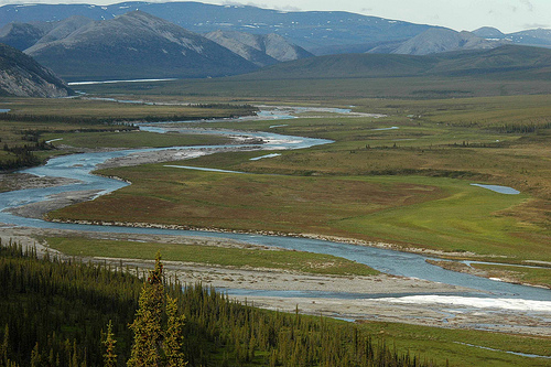
Ivvavik National Park occupies the Yukon North Slope, bordering
Vuntut National Park to the southeast and Alaska’s Arctic National
Wildlife Refuge to the west. Its location within the Arctic Circle
ensures extreme conditions and unique natural features.
Landscape:
Terrain: The park encompasses the British Mountains, an
eastern extension of Alaska’s Brooks Range, running east-west parallel
to the Arctic coast. These non-glaciated mountains, formed during the
early Cenozoic, feature rounded, treeless peaks, craggy tors, and
windswept ridgelines, with Arthur Laing Peak (1,764 m/5,787 ft) as the
highest of eight named summits. Smooth river valleys, eskers, and hills
cut through the range, creating a dramatic tundra landscape. The coastal
plain along the Beaufort Sea transitions from alpine tundra in the
mountains to Arctic tundra, with flat, ice-cored pingos visible near
Tuktoyaktuk.
Water Bodies: The Firth River, the park’s centerpiece,
is Canada’s oldest river and a world-class whitewater rafting
destination. Originating in aufeis (ice-sheet) formations, it flows 120
km north through canyons, valleys, and a massive delta into the Beaufort
Sea, offering exceptional beauty and archaeological sites. Other rivers,
like the Babbage, support Arctic char spawning. Small lakes, creeks, and
ponds dot the tundra, vital for wildlife.
Climate: Ivvavik’s Arctic
climate features long, severe winters (–30 to –10°C, November–April) and
short, cool summers (5–25°C, June–August, averaging 14°C). The midnight
sun provides 24-hour daylight from May to July, ideal for hiking and
wildlife viewing, while autumn (late August) brings vibrant tundra
colors but risks snow and fog. Extreme weather, including –15°C summer
lows and strong winds, requires preparation. Annual precipitation is low
(~300 mm), with heavy fog common along the coast.
Geological
Significance: Unlike most Canadian mountains scoured by the Laurentide
Ice Sheet, Ivvavik’s British Mountains were part of Beringia, an
ice-free landmass during the Wisconsin Ice Age, preserving ancient
sediments like limestone and sandstone. This unglaciated terrain, unique
in Canada, supports diverse plant and animal communities.
Ivvavik’s diverse habitats—Arctic tundra, alpine tundra, boreal
forest, and coastal plains—support a rich array of wildlife and flora,
though remoteness and climate limit species density. The park is a
critical sanctuary for the Porcupine caribou herd and other Arctic
species.
Flora:
Dominant Species: The tundra blooms with
wildflowers (e.g., Arctic poppies, lupines), grasses, and shrubs like
dwarf birch and willow during the short summer (late June–early July).
Boreal forest patches in southern valleys feature spruce and larch, with
mosses and lichens covering the ground. The park’s ice-free history
preserves ancient plant communities, studied for climate resilience.
Conservation: Overgrazing by caribou and climate-driven permafrost thaw
threaten vegetation, prompting Parks Canada’s monitoring programs.
Invasive species are minimal due to remoteness, but warming temperatures
risk ecological shifts.
Fauna:
Mammals: The Porcupine caribou
herd (100,000–200,000) is the park’s flagship species, calving on the
coastal plain to avoid predators and insects. Other mammals include
grizzly bears, black bears, polar bears (rare, coastal), Yukon moose,
muskoxen (growing population), Dall sheep (northernmost range in
Canada), timber wolves, red foxes, wolverines, and lemmings. Bears are
commonly sighted, with grizzlies most frequent.
Birds: Over 120
species, including migratory and resident birds, nest in Ivvavik.
Notable species include gyrfalcons, peregrine falcons, snow geese, and
other waterfowl breeding on the coast. The park’s interactive wildlife
map tracks species like Arctic terns.
Fish: The Firth and Babbage
Rivers host some of Canada’s longest stocks of Dolly Varden char, with
fishing permitted under strict permits (daily limit: 1 char, possession
limit: 3). Arctic grayling and other species support Inuvialuit
subsistence.
Challenges: Climate change threatens caribou calving
grounds by altering tundra vegetation and insect patterns. Poaching is
minimal, but habitat disturbance from rare human activity (e.g.,
research) requires careful management. Polar bear sightings, though
uncommon, are monitored due to their unpredictable behavior.
Conservation Efforts: The park’s management plan prioritizes caribou
protection, limiting visitors to 100–179 annually to minimize
disturbance. Remote wildlife cameras monitor grizzlies and caribou, as
noted in a 2017 Parks Canada post, aiding research. The Inuvialuit
Traditional Use Study (2020s) informs sustainable practices, balancing
conservation with cultural activities.
Ivvavik’s remoteness, accessible only by charter plane from Inuvik
(200 km east), shapes its minimal infrastructure, centered on the
Imniarvik Base Camp at Sheep Creek. Activities focus on wilderness
immersion, guided by Parks Canada and Inuvialuit hosts.
Access:
By Air: Charter flights (Twin Otter, $2,000–$5,000 round-trip) from
Inuvik to landing strips like Sheep Creek, Margaret Lake, Komakuk Beach,
or Stokes Point take 1–1.5 hours, offering stunning views of the
Mackenzie Delta and British Mountains. Inuvik, reachable via daily
flights from Whitehorse or Yellowknife ($500–$1,500), is the staging
point, with a mandatory Parks Canada orientation at the Inuvik office
(867-777-8800).
By River: Firth River rafting expeditions (late
June–early August, $5,000–$10,000) start in Old Crow, Yukon, or park
airstrips, requiring whitewater experience and permits. No roads access
the park, ensuring its pristine state.
Permits: All visitors need a
Parks Canada permit ($157.60/year for backcountry camping, 2024), with
registration at Inuvik. Hikers must submit detailed routes (1:50,000
scale maps) and carry communication devices.
Key Attractions:
Imniarvik Base Camp (Sheep Creek): A solar-powered camp with wall tents,
comfy beds, propane heaters, a cookhouse, lounge, toilets, showers, and
an electric bear fence. Accommodating up to nine guests, two Parks
Canada staff, an Inuvialuit cook, and a cultural host, it offers guided
hikes, cultural talks, and meals (accommodating allergies, per 2022
FAQ). Inuvialuit hosts share stories of traditional life, enhancing
cultural immersion. The camp, described as “surprisingly comfortable” in
a 2018 Tripadvisor review, operates June–July, with 2025–2026 bookings
via infoinuvik-inuvikinfo@pc.gc.ca.
Firth River: A world-class
whitewater river, flowing through canyons, valleys, and a delta to the
Beaufort Sea. Rafting (Class III–IV rapids) is popular, with trips (7–10
days) showcasing archaeological sites and wildlife. A 2023 review called
it “thrilling” for its scenery and remoteness.
British Mountains:
Eight named peaks, including Arthur Laing Peak, offer rugged hiking
routes with V-shaped valleys and long ridges. No designated trails
exist; hikers follow natural landmarks (rivers, ridges), requiring maps,
GPS, and guides ($100–$200/day). Late June–early July wildflower blooms
and August’s autumn colors are highlights, though fog and snow are
risks.
Beaufort Sea Coast: The coastal plain, a caribou calving
ground, features tundra, pingos, and polar bear habitat. Wildlife
viewing (caribou, bears, foxes) is a draw, with guided tours ensuring
minimal disturbance.
Cultural Sites: Inuvialuit archaeological sites,
used for hunting and gathering, are protected and accessible only with
cultural hosts to respect their sanctity. The 2021 tri-lingual map
highlights traditional place names.
Activities:
Hiking: Seven
approximate routes from base camp (e.g., Sheep Creek, Margaret Lake)
involve navigating valleys, ridges, and creeks. Hikers must carry bear
spray, check in/out with camp leaders, and submit plans. A 2025 Hike
Bike Travel review praised the “fantastic” hiking and wildlife.
Rafting: Firth River trips (June–August) require permits and experience,
with outfitters like Nahanni River Adventures offering guided
expeditions.
Wildlife Viewing: Caribou, grizzly bears, Dall sheep,
and birds are best seen in summer, with binoculars recommended. A 2023
Global National Parks guide noted “luck” spotting grizzlies.
Fishing:
Dolly Varden char fishing requires permits (1 daily catch, 3 possession
limit), supporting Inuvialuit traditions.
Cultural Experiences:
Inuvialuit hosts share stories, games, and skills (e.g., berry picking),
with 2018 reviews praising hosts like Nellie and Renie for their warmth.
Amenities: Base camp provides solar-powered facilities, including a
cookhouse with Inuvialuit cuisine (e.g., Nellie’s buns). No cell service
exists, but charging stations support cameras. Backcountry campers need
bear-proof containers and self-sufficiency, with no designated
campsites. The Inuvik Parks Canada office offers orientation, fishing
permits, and souvenirs like muskox plushies.
Ivvavik is a living testament to Inuvialuit heritage and Canada’s
commitment to Indigenous reconciliation, while its natural splendor
holds global ecological value.
Inuvialuit Culture: The park lies
within the Inuvialuit Settlement Region, where traditional practices
like hunting, fishing, and family gatherings continue. The Inuvialuit
Final Agreement ensures these rights, with cultural hosts at base camp
teaching visitors about caribou connections, storytelling, and land
stewardship. The 2020s Traditional Use Study highlights coastal
corridors as vital cultural routes. A 2025 review noted the
“deep-rooted” Inuvialuit presence as a trip highlight.
Spiritual
Significance: The caribou calving grounds are sacred to the Inuvialuit,
symbolizing life and renewal. The park’s name, Ivvavik (“birthplace”),
reflects this, with cultural sites protected to maintain spiritual
continuity. Visitors are educated on respecting these spaces, per Parks
Canada guidelines.
Community Impact: The park supports Aklavik’s
Inuvialuit community (population ~600) through jobs as cooks, hosts, and
guides, with base camp staff drawn locally. Tourism generates modest
revenue (~$100,000/year from 100 visitors), but economic benefits are
limited by low visitation. The Inuvialuit Regional Corporation reinvests
in community programs, per the 1984 agreement.
Global Significance:
As an ASEAN Heritage Park contender and part of Beringia, Ivvavik’s
ice-free history and caribou herd draw international researchers. Its
Indigenous-led model is studied globally, though its remoteness limits
broader recognition.
Ivvavik’s isolation preserves its pristine state but poses logistical
and conservation challenges, reflecting broader Arctic issues.
Remoteness and Access: Accessible only by costly charter flights
($2,000–$5,000), Ivvavik is prohibitively expensive, with 179 visitors
in 2022–23. Inuvik’s distance (200 km) and limited flights (via
Whitehorse, $500–$1,500) exclude most travelers, as noted in a 2023
Planet D review calling it “harder to reach than Australia.” This limits
tourism revenue and public awareness.
Wildlife Threats: Climate
change disrupts caribou migration through warmer summers and insect
proliferation, reducing calf survival. Polar bear sightings, though
rare, increase with melting sea ice, raising safety concerns. Poaching
is minimal, but research disturbances require strict protocols.
Environmental Strain: Permafrost thaw, driven by 2–3°C Arctic warming
since 1980, destabilizes tundra and rivers, impacting caribou grounds.
Fog and storms, delaying flights, strand visitors, as reported in 2025
Hike Bike Travel. Limited rescue services (weather-dependent,
Inuvik-based) heighten risks.
Cultural Preservation: While the
Inuvialuit Final Agreement protects traditional use, balancing tourism
with sacred site sanctity is delicate. Overzealous visitors, though
rare, risk cultural insensitivity, mitigated by mandatory orientations.
Management Issues: Parks Canada’s budget (~$500,000/year for Ivvavik)
and small staff (5–10 in Inuvik) limit trail development and
enforcement. The 2022 COVID-19 restrictions (no private bookings,
reduced rescue) highlight operational constraints, though eased in 2025.
Commercial outfitters face strict permitting, reducing overcrowding but
limiting access.
Equity Concerns: The $157.60 camping permit and high
travel costs exclude low-income and non-local Inuvialuit, despite free
entry for locals. Economic benefits favor Inuvik over Aklavik, with
median incomes (~$30,000/year) unchanged by tourism. Community-led
guiding could enhance equity.
Strengths:
Pristine, unglaciated
wilderness with unique Beringia ecosystems.
Critical caribou calving
grounds and diverse wildlife (bears, sheep, birds).
Inuvialuit-led
cultural experiences, a model for Indigenous conservation.
Comfortable base camp and world-class Firth River rafting.
Opportunities:
Expand ecotourism with more base camp trips or virtual
tours.
Increase Inuvialuit-led guiding to boost local economies.
Enhance research on climate impacts, leveraging global interest.
Develop digital maps and apps for safer navigation, per 2021 map
initiative.
Ivvavik offers an unparalleled Arctic adventure, best experienced via
the Imniarvik Base Camp (5-day trips, June–July, $5,000–$7,000), with
guided hikes, cultural immersion, and Firth River rafting. Its
remoteness ensures exclusivity but demands preparation.
Highlights:
Base Camp: Solar-powered tents with beds, heaters, and a
cookhouse offer “surprising comfort” (2018 Tripadvisor). Inuvialuit
hosts like Nellie share stories and buns, while hikes to ridges and
valleys reveal caribou and bears. A 2025 review praised the “stunning”
flight over the Mackenzie Delta.
Firth River Rafting: Class III–IV
rapids through canyons and tundra, with archaeological sites, are
“thrilling” (2023 review). Trips (7–10 days) require permits and
outfitters.
Wildlife Viewing: Caribou migrations (June–July), grizzly
sightings, and gyrfalcons are highlights, with wildflowers carpeting the
tundra. Binoculars are essential, per 2023 Global National Parks.
Cultural Immersion: Learning Inuvialuit games and history from hosts
like Renie is “unforgettable,” per a 2025 Hike Bike Travel review
celebrating Canada Day.
Activities:
Hiking: Route-based hikes
(no trails) follow rivers and ridges, requiring GPS, maps, and bear
spray. A 2025 reviewer noted “endless” hiking possibilities but urged
guide reliance.
Rafting/Fishing: Firth River trips and char fishing
(1/day limit) are guided, ensuring safety and cultural respect.
Photography: Midnight sun and tundra colors yield “tourist brochure”
shots, per a 2019 Canadian Bucket List blog.
Tips:
Best Time:
Late June–early July for wildflowers and caribou; August for autumn
colors, but prepare for snow/fog.
Essentials: Bring warm clothing
(–15°C possible), bear-proof containers, GPS, compass, and cancellation
insurance (weather delays common). Modest attire respects Inuvialuit
hosts.
Safety: Bear safety briefings (grizzly, black, polar) are
mandatory, with food stored 50 meters from tents. Unstable slopes and
cliffs require caution, especially in rain. Emergency rescue is limited,
per 2022 FAQ.
Planning: Book base camp trips early (9 slots/trip, 5
trips/year) via Parks Canada (867-777-8800). Charter flights and permits
are arranged post-booking. Solo hikers need detailed plans and permits.
Visitor Feedback: 2025 Tripadvisor and Hike Bike Travel reviews laud the
“magnificent” wilderness, “excellent” food, and cultural hosts, with a
2018 couple calling the Twin Otter flight “amazing.” Complaints include
high costs ($5,000+), weather delays, and navigation challenges without
guides, with a 2023 reviewer noting the “vast” landscape’s disorienting
scale.