Location: Alberta Map
Area: 10,878 km2 (4,200 sq mi)
Official site
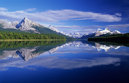
Jasper National Park is the largest park in the Canadian Rockies
and is located in Alberta. It provides almost unlimited
opportunities for active recreation. In addition, the park is easily
accessible, and the landscapes here range from rivers, lakes and
waterfalls to alpine meadows, snow-capped peaks and glaciers. Along
with six other parks in Alberta and British Columbia, Jasper makes
up the Parks of the Canadian Rockies World Heritage Site.
The
park occupies a vast area in the Athabasca River valley and the
valleys of its tributaries. The Athabasca itself begins at the
southwest end of the park, flowing from an unnamed lake at the edge
of the Columbia Icefield. On Athabasca, within the park, stands the
town of Jasper, the local center of civilization with a park
information center, a gas station, a train station and a scattering
of hotels, restaurants and shops. Then the Athabasca flows to the
northeast and leaves the park as a rather large river - then it
flows into Lake Athabasca in the Mackenzie River basin.
Jasper Park Information Center (in downtown Jasper, across from the
station). From mid-May to mid-October Mon–Sun 9:00–19:00, the rest
of the time Mon–Sun 9:00–17:00, December 25, 26 and January 1
closed.
The main road that runs through Jasper National Park is Highway 16 (Yellowhead). You can drive here from Hinton (69 km away) or from Edmonton (35 km away). Another major city in the area of Jasper National Park is Valemount (110 km).
By Train
There are no passenger airports in the park, and you can get to the
park either by car, train or bus.
1 Jasper railway station
(downtown Jasper). The only train station within the park is in the
city of Jasper. The Canadian train passes through Jasper on the
Toronto-Vancouver route, twice a week, in season (from May to
mid-October) three times a week, from Toronto on Monday, Thursday
and Friday at 6:30, stop for three hours, from Vancouver on Monday ,
Tuesday and Friday, 11:00, parking for an hour and a half. Travel
time to Vancouver is 19 hours, to Edmonton 6 hours. There is also a
train service to Prince George three times a week, where you can
change trains to Prince Rupert. This train departs Jasper on
Wednesdays, Fridays and Sundays at 12:45 pm and arrives on Mondays,
Thursdays and Saturdays at 4:00 pm, with a journey of seven and a
half hours. Do trains run infrequently and are significantly slower
than cars, and are quite expensive? thus used more as entertainment
than as a means of transport. Additionally, Rocky Mountaineer
maintains routes from Vancouver and Kamloops to Jasper, but these do
not even claim to be transport links and are sold as part of an
excursion package. Regardless of whether you take the train or not,
Jasper Station is interesting in its own right - there is quite a
lot of freight traffic there, and you can see locomotives and
freight trains against the backdrop of cliffs or snow-capped
mountains.
The easiest way to get to the park is by car,
since one of the main roads crossing the Rocky Mountains, Route 16,
passes through it. Transit along it through the park is free (in
this case, you will need to select a transit window when entering
the park), but without If you have a Kuplan pass to the park, you
will only be able to stay on this road itself and, perhaps, go to
the city of Jasper, where you will need to buy a pass at the
information center. This road goes east to Edmonton, west to Prince
George, but you can turn off it and go to Vancouver. In Jiasper,
road 93 (Icefields Parkway) branches off to the south, which goes
along the ridge into Banff National Park.
By Plane
The closest international airport to Jasper National Park is located in Edmonton and Calgary. Domestic flights can take you closer to the Springbank Airport located nearby.
All visitors stopping in the park (even just for
gas) require a park permit. If you are driving through non-stop, the
pass is not required. Day passes and annual passes are available.
All Canadian National Parks require visitors to pay an entry
fee. Canadian residents and international visitors pay the same
fees. The national parks in Alberta and BC are fairly close to each
other and it is possible to visit several of them in a single day.
If you pay an entry fee in one mountain park (e.g. Banff National
Park), and visit another on the same day (e.g. Yoho National Park),
you will not have to pay a second time. Your paid entry fee is valid
until 4PM the following day.
The fees that visitors pay do
not go to general government revenues; they are used to enhance and
maintain the parks and visitor services.
For 2018, the entry
fees are:
$9.80 per day for an adult (aged 17-64)
$8.30 per
day for a senior (aged 65+)
free for children and youth (aged
0-16)
If you are entering the park as a group of 2-7
people travelling in a single vehicle, you can pay the group fee of
$19.60 per day. (This is the same fee as paying for two adults.)
If you will be visiting Canadian National Parks for 7 days or
more, you may save money by purchasing an annual Discovery Pass:
$67.70 for an adult
$57.90 for a senior
$136.40 for a
family/group
A Discovery Pass includes admission to national
historic sites operated by Parks Canada, such as the Banff Park
Museum, Cave and Basin National Historic Site, Bar U Ranch, Rocky
Mountain House National Historic Site, and Fort Langley National
Historic Site. Parks Canada does not operate all of Canada's
national historic sites.
Additional variable fees are
required for camping and backcountry exploration. See the official
Parks Canada website for a complete current schedule.
A Park
Pass is also required for anyone travelling the Icefields Parkway
(#93) between Lake Louise and Jasper.
Jasper National Park is one of the parks in Canada's Rocky Mountains where the conflict between conservation and mass tourism is very clear. Every year, more than nine million people visit the region's seven national parks, with the park around Jasper having to cope with almost 2.5 million visitors, more than a quarter of this. The park is also the second most visited national park in Canada, after Banff National Park. The influx of visitors is concentrated at certain points and primarily during the summer holiday season.
1 Viewpoint on Road 16. About 20 km from the eastern entrance to the
park, there will be a fairly large parking lot on the left side, from
which you can easily access the Athabasca Coast. There is no forest
here, and there are views of the mountains on the other side of the
river and higher up the valley. However, there are no signs either, and
the names of the mountains will then take a long time to decipher from
photographs. Since the parking lot is located on a transit road, you can
leave your car there without even paying to enter the park.
2 Two Brothers totem pole (Jasper, near the train station). If you are
coming from British Columbia, then most likely you have seen enough
totem poles, and if you are coming from Alberta, then this may be the
first one you have seen in your life. The pillar was erected in 2011 by
Haida carvers, Jaalen and Gwaai Edenshaw, and the second, better known
as a writer and composer, is generally a fairly prominent figure in the
culture of the indigenous peoples of Canada. The pillar shows the story
of two brothers who were separated at some point and then met again. All
the figures carved on it can be easily distinguished; these are two
brothers, the daughter of one of them, a raven, a bear, an ibex and a
dragonfly. The impression is completed by views of the mountains south
of Jasper, against which the pillar is placed.
Athabasca River – 1,231 kilometer long river that flows through the
national park
Athabasca Falls – Waterfalls that have carved their way
through the rock
Athabasca Glacier – Glacier that can be navigated
with so-called snowcoaches and is part of the Columbia Icefield
Columbia Icefield – 325 km2 glacial area
Columbia River – 1,953
kilometer long river that flows through the national park
Horseshoe
Lake – smaller lake
Icefields Parkway – 231 kilometer long highway
from Jasper to Banff through the middle of the Rocky Mountains
Jasper
– a town with almost 4,000 inhabitants and located at an altitude of
1,067 m
Maligne Canyon – narrow canyon up to 55 meters deep with
hiking trails
Maligne Lake – largest (22 kilometers long) and deepest
(97 meters) lake in the park with the most famous photo opportunity in
the park (Spirit Island)
Medicine Lake – popular recreational lake on
the road to Maligne Lake with an underground drain
Miette Hot Springs
– hot springs whose water is piped into a swimming pool
Mount
Columbia – at 3747 m high, the highest point in the park
Mount Edith
Cavell – 3363 m high mountain southwest of the town of Jasper
North
Saskatchewan River – 1287 kilometer long river that flows through the
national park
Pyramid Lake – popular excursion lake near the town of
Jasper
Snake Indian River – remote river in the far north of the
national park
Yellowhead Pass – historic site and overlook
Whistlers Mountain – 2285 m high scenic mountain near the town of Jasper
The Glacier Skywalk, a viewing point that has been accessible for a fee
since May 2014, towers over a precipice and is modeled on the Grand
Canyon Skywalk in Arizona.
In 2011, 11,228 km² around the national
park were also designated as a Dark Sky Preserve.
There are literally thousands of kilometers of trails in the park, of
varying difficulty and distance from housing. In some places an hour
will be enough for you, and in others you will need several days.
1 Pyramid Lake. If you are passing through the park and are not
going to spend the night there, then a walk near the lake is one of the
easiest options. The lake is located six kilometers from Jasper, and
there is a paved road (Pyramid Lake Road) leading to it, ending with a
parking lot (usually there are places on it). The main thing here is the
views across the lake to Mount Pyramid, truly pyramidal in shape and
2766 m high (lake level 1180 m). From the parking lot, the Pyramid Lake
and Athabasca Overlook hike begins, along which you can climb in two
hours with views of both the lake itself and neighboring Patricia Lake,
the Athabasca River valley and the city of Jasper, and then descend
back. The trail is well marked and does not require any equipment or
special training, although you are unlikely to be comfortable on it in
flip-flops. On the way back, near the parking lot, go to Pyramid Island,
from there there are good views of the lake in all directions.
Standard Bear Safety Precautions: Bears, including grizzly bears, can be encountered anywhere, including the city of Jasper. Stay on the trail, make some noise as you walk, if you are in a group, walk together, if you see a bear, stop and let it go. Do not come closer than one hundred meters to bears.
The park is home to such animal species as deer, elk, mountain goat, bighorn, wolf, grizzly bear, American marten, Canadian lynx, wolverine, beaver, ground squirrel, tree porcupine, muskrat, squirrel, as well as about 200 species of birds.
Plant species commonly found here include pines (pond, Weymouth and lodgepole), giant fir, Engelmann spruce, larch and juniper.