Location: Northwest Territories Map
Area: 30,000 km2 (11,583 sq mi)
Nahanni National Park is situated in Northwest Territories of Canada. Nahanni National Park covers an area of 30,000 km2 (11,583 sq mi). Nahanni National Park is located in the Mackenzie Mountains Natural Region. It territory encompasses a basin of the South Nahanni river. The name Nahanni comes from the local native American dialect of indigenous Dene people who called this river Naha Dehe what can be translated as "the river of the land of the Naha people". The area of Nahanni National Park is dominated by four canyons that named First, Second, Third and Fourth. The deepest canyon reaches a depth of 1,000 meters or 3,300 feet in depth.
The Nahanni National Park, in the Northwest
Territories of Canada, about 500 kilometers west of Yellowknife,
protects a part of the natural region of the Mackenzie Mountains. It
has an extension of 4766 km2, and was created in 1976. In 1978 it
was declared a World Heritage Site by Unesco. The park is crossed in
its entire length by the South Nahanni River, which runs marked by
four large canyons. In the central area of the park is the largest
waterfall in North America, the Virginia Falls; On a 200-meter
front, the river rushes from a height of 92 meters, twice as high as
the Niagara Falls. In the center of the waterfall a rocky
outcropping of glacial origin appears, called Mason's Rock in honor
of Bill Mason, famous Canadian canoeist, writer and filmmaker. There
is a proposal to rename the falls with the name of Pierre Trudeau,
former prime minister of Canada.
The natural environment of
the park consists of forests of fir and poplar trees, alpine tundra,
mountain ranges, sulphurous thermal springs and a system of karst
caves, and hosts many species of fish, birds and mammals. There is a
visitor center in Fort Simpson, the nearest city, where the
geography, culture and history of the region are explained. The only
practical means to get to the park are the hydroplane and the
helicopter.
Nahanni National Park Reserve covers an area of
30,050 km² (11,600 sq mi), almost the size of Belgium, approximately
500 km (311 mi) west of Yellowknife. It protects a portion of the
Mackenzie Mountains Natural Region. The centrepiece of the park is
the South Nahanni River (Naha Dehé). Four canyons reaching 1,000 m
(3,300 ft) in depth, called First, Second, Third and Fourth Canyon,
line this whitewater river.
The name Nahanni comes from the
indigenous Dene language name for the area; Nahʔa Dehé, which means
"river of the land of the Nahʔa people", who some now speculate may
have been the ancestors of the modern day Navajo people.
Nahanni National Park Reserve Headquarters, Box 348, Fort Simpson,
NWT, X0E 0N0,, ☎ +1 867 695-3151, e-mail:
nahanni.info@pc.gc.ca.
Winter (September 15 - June 15) M-F 8:30AM-noon, 1PM-5PM. Closed
weekends. Summer (June 15 - September 15) Daily 8AM-noon, 1PM-5PM.
Northern Park Backcountry Excursion/Camping Permit
valid at Nahanni, Auyuittuq, Ivvavik, Aulavik, Quttinirpaaq,
Sirmilik, Tuktut Nogait and Vuntut National Parks (per person,
2018):
Daily $24.50
Annual $147.20
Fishing permit:
Daily $9.80
Annual $34.30
The creation of the national park was first proposed in the later
1960s. This was preceded by plans to build a hydroelectric dam on the
South Nahanni River below Virginia Falls, which would have had serious
environmental impacts. In 1972, the first park corridor was established
along the river, from the edge of the batholith cliffs (“Ragged Range”)
at Rabbitkettle Lake to downstream to the mouth of the Liard River.
In 1971, newly discovered limestone caves at First Canyon were
investigated, leading to further study of the reserve's geomorphology
and hydrology on behalf of Parks Canada. After the simultaneous
documentation of the flora, fauna and ecozones, the reserve was
inscribed as a UNESCO World Heritage Site in 1978.
In 2009, the
park was significantly expanded to include the Ram Basin and the entire
South Nahanni Basin, which is owned by the Dehcho First Nations.
Excluded from the expansion of the national park are the two mining
areas on the Flat River (Cantung) and on Prairie Creek, a tributary on
the north bank of the South Nahanni, where zinc, lead and silver are
mined. In 2012, the Sahtu First Nations area bordering the park to the
northwest was established as Naats'ihch'oh National Park.
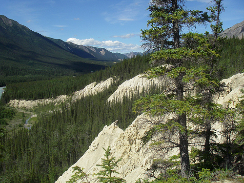
The park is located in the northern part of the Taiga Cordillera, a
varied landscape zone with mountain ranges, rolling hills, plateaus,
broad depressions and incised valleys. The western end is formed by the
Selwyn Mountains of the Mackenzie Mountains and the saw-toothed,
volcanic Ragged Range, each of which has glaciers. The southern border
is the Boreal Cordillera, the eastern edge extends into the taiga plain.
In a valley below the Ragged Range, the Rabbitkettle, a 200-foot-wide
tuff mound, is stacked 100 feet high with intricate terraces around a
hot spring. In stark contrast, in the center and east of the park are
sections of deeply rugged sandstone, mud, shale, and limestone hills of
the Funeral Range and Headless Range, as well as the Tlogotsho Plateau
and Liard Plateau, and the Mackenzie Mountains. With a height of 2773 m,
Mount Nirvana is the highest point in the park.
Large parts of
the park center have remained unglaciated for up to 300,000 years. At
the eastern end are 6 m high, wind-eroded shapes of white sandstone,
called sand blowouts, and Lake Yohin. The limestone landscape in the
catchment north of the reserve is considered to be the most significant
subarctic karst with the most prominent decomposed karst landscape in
the Northern Hemisphere. The Valerie Cave, which is closed to visitors,
is considered one of the most beautiful ice caves in the world. It
contains large chambers, a 1,900 m long tunnel system and the “Gallery
of Dead Sheep”, where around 100 lost Dall sheep died.
Approximately 270 kilometers of the South Nahanni River, which drains
into the Mackenzie Basin via the Liard River, and one-seventh of its
35,000 square kilometers of drainage basin lie within the park. The
South Nahanni and its tributary, the Flat River, are older than most of
the mountain ranges that flank them. Within the park, the river loses a
total of 475 meters in height; over the spectacular Virginia Falls
alone, which are almost twice as high as Niagara Falls, it plunges over
90 meters into the depths. It then flows 70 kilometers through a series
of four gorges 460 to 1200 meters deep and through karst terrain with
grottoes, sinkholes, labyrinths, narrow gorges and an underground river
system. River levels are low in winter, but following the spring melt,
severe flooding and flash flooding occur from June to September.
There is a cold continental climate with strong monthly fluctuations in temperature and precipitation. The maximum and minimum temperatures recorded in Fort Liard are 34 °C and −46.7 °C, respectively. From June to August, mean high and low temperatures at Tungsten, 35 km west of the park, are 17°C and 6°C; the absolute high and low values for these months are 30°C and 0°C, respectively. Average monthly rainfall from June to August is between 60 and 90 mm, with severe thunderstorms possible in July. As altitude increases, temperatures decrease and precipitation increases. Snowfall is possible at any time of the year.
The park contains plant species from two major ecosystems: the
Nearctic taiga and the Nearctic alpine tundra, and the transition phases
between them. All levels of boreal forest occur, from burnt plains to
ancient spruce forests, and from moist lowlands to alpine tundra. Over
700 species of vascular plants and 325 species of moss have been
recorded in the park, making it the most diverse vegetation of any
comparable area in the Northwest Territories. This can be attributed to
the presence of highly specialized habitats such as hot and cold mineral
springs, waterfall mist zones, moist calcareous substrates and
unglaciated terrain.
The valley floors are dominated by densely
growing white spruce and poplar. Black spruce is more prevalent at
higher altitudes and on the northern slopes, and lodgepole pine is more
prevalent in the west. Near Virginia Falls there is an area of
spruce-larch/lichen taiga with several species of orchids. The alpine
tundra, characterized by sedges, lichens, grasses and shrubs, occurs in
the higher mountain regions of the Tlogotsho, Headless and Funeral
Ranges. The wild mint lamius, goldenrod, yellow jellyfish and the
endemic Nahanni aster are among the many flowering plants that grow
abundantly next to mineral springs near the Flat River.
The wildlife is very diverse for the park's relatively high latitude
and is influenced by seasonal migration or wintering. 42 species of
mammals are found, including the Canada beaver, gray wolf, grizzly bear,
black bear, North American otter, wolverine, Canada lynx, Canadian
woodland caribou, elk, white-tailed deer, mountain goat, Dall sheep and
a variety on rodents.
A total of 180 bird species from 29
families were observed, including the American peregrine falcon, golden
eagle and bald eagle. A small population of trumpeter swans, a very rare
species in Canada, nests at Lake Yohin. There are also 16 known species
of fish. Arctic grayling, Dolly Varden trout, American lake trout and
bull trout are found in the tributaries of the Nahanni and Flat Rivers.
Population
There are signs that the park area was used in prehistoric times.
When fur trading companies established their posts along the Mackenzie
River in the 1820s, the Goat or Mountain Indians known as Kaska lived
there. These were displaced by the Mountain Dene tribe of the Dehcho
First Nations, a Slavey-speaking people.
Today, about 100 Nahani
Dene live in Nahanni Butte, at the confluence of the Liard and South
Nahanni rivers at the southern end of the park.
Fort Liard, the
next major settlement outside the park, did not receive a road
connection to the Alaska Highway until 1979. In 1981, around 2,000
people lived around the park. Fort Liard and Jean Marie are 90%
indigenous Denes and Métis (mixed-blood) communities. Fort Simpson
(population 981) is almost equally divided between an Indigenous and
non-Indigenous population. To the west of the park is the Tungsten
settlement, which belongs to a private mining company and has 380
inhabitants.
The main economic activities include oil and gas production, mining, timber, air and road transport, and handicrafts.
The season is relatively short, with around 89% of visitors coming in
the months of July and August.
For visitors, there are hiking
trails and overlooks and four campgrounds at Rabbitkettle Lake, Portage
Landing, Virginia Falls and Kraus Hotsprings. At the first two
locations, park staff offer nature interpretations and guided hikes.
Tours to the park must be registered with the Fort Simpson Visitors’
Information Center. Whitewater paddling with a canoe or kayak, hikes
along a river bank and one-day flight tours are popular. Since the park
is difficult to reach, charter flights from nearby cities are the
preferred and most convenient means of travel. There are regular flights
from Fort Simpson, Watson Lake or Fort Nelson to Rabbitkettle Lake and
Virginia Falls.
Registration as a world natural heritage site
Designated in 1976,
the national park was inscribed on the UNESCO World Heritage List in
1978 as the first World Heritage Site in Canada following a decision at
the second meeting of the World Heritage Committee. The meeting also
included the Viking settlement of L’Anse aux Meadows as the country’s
first World Heritage Site.
The World Heritage Site covers an area
of 476,560 hectares.
The justification for the entry states,
among other things:
The World Heritage Site of Nahanni National Park,
located in Canada's Northwest Territories, is a 470,000-acre pristine
natural area with deep river canyons cutting through mountain ranges,
massive waterfalls and complex cave systems. The park's geomorphology is
striking in its richness of form and diversity of evolution. ...Within
the park are examples of almost every known category of river or stream,
along with one of North America's most impressive waterfalls, Virginia
Falls. The Flat River and the South Nahanni River are older than the
mountains they cut through, both producing the most excellent examples
of river canyons north of the 60th parallel.
The entry was made
based on criteria (vii) and (viii).
(vii): The South Nahanni River is
one of North America's most spectacular wild rivers, with deep gorges,
huge waterfalls and spectacular karst terrain, cave systems and hot
springs. Outcrops of geological and geomorphological forms show the
meanders of ancient rivers that lie high above the current river level.
(viii): Nahanni National Park has an exceptional representation of
ongoing geologic processes, particularly fluvial erosion, tectonic
uplift, folding and canyon formation, wind erosion, karst and
pseudokarst forms, and a variety of hot springs. The main geological and
geomorphological forms offer a combination of geological processes that
are unique in the world.
Nahanni National Park Reserve is managed by Parks Canada under the
Canadian National Parks Act of 2002 and the Parks Canada Agency Act of
1998, and the MacKenzie Valley Resource Management Act of 1998.
Fort Simpson is home to the park's administrative center and Nahanni
Butte has a year-round visitor center. A management plan was first
created in 1987 and renewed in 2004. In 2003, a tentative park
management agreement was reached between Parks Canada and the Dehcho
First Nations.
The park was divided into three zones:
Zone I,
Special Protection: No motorized or mechanical installations are
permitted in this area, except for local residents. Seven areas,
including several hot springs, the Deadmen Valley Sheep Licks, and the
Sand Blowouts are located in this zone.
Zone II, Wilderness: Designed
for wilderness protection and includes the entire South Nahanni and Flat
River corridors, excluding the immediate area of Virginia Falls and
Rabbitkettle Lake.
Zone III, Wilderness Recreation: Designated for
areas that are considered natural areas but can support select,
low-density outdoor activities, including Rabbitkettle Lake and Virginia
Falls.
The zoning concept takes into account the harvesting of
natural resources by locals and other traditional activities such as
hunting, fishing and trapping.
A monitoring program has been set
up for around 20 subject areas, including: for water quality, wildfires,
bears, Dall sheep, breeding birds and park visitors.
Because of its wealth in raw materials, the region is of interest for
mining, oil and gas production. There are several old mines and ongoing
exploration within the watershed. The federal ministry Indigenous and
Northern Affairs Canada, which is responsible, among other things, for
the economic and industrial development of the northern territories, is
trying to promote this development here too and began issuing
prospecting permits within the area a few years ago. The Mackenzie River
Environmental Impact Review Board has already approved licenses for over
400 km of oil and gas pipelines in the area. In the event of floods or
earthquakes, to which the region is prone, mining in the park's
watershed would almost certainly pollute its waters with chemicals,
fuels and wastewater, particularly negatively impacting caribou, Dall
sheep and fish populations would.
The Canadian Zinc Corporation
has owned an abandoned zinc, lead, silver and copper mining site since
1983 with fully developed infrastructure on Prairie Creek, a slot canyon
tributary 15 km upstream, which it is now seeking to develop and for
which permits were issued in 2005 . To reach the area, an improved 165km
year-round road is planned through the exceptional karst landscape north
of the park, but has not undergone an environmental impact assessment as
required by the Mackenzie Valley Land and Water Board. Transport roads
and mining can destroy the integrity of the site and poison groundwater
with contamination from arsenic, antimony and mercury, which is often
found in ores. 40 tons of cyanide are stored on site and the toxic
tailings pond is located in a valley prone to flash floods and
earthquakes. The dirty water containing sulfuric acid would travel long
distances both over land and below the surface.
The planned
reopening of a tungsten mine (at Tungsten) 45 km upstream on the Flat
River, which closed in 2003, could also strain the rivers. Park staff
are working with Greater Nahanni Ecosystem stakeholders such as the
Dehcho and Sahtu First Nations to address these potential threats. In
2003, an agreement was signed to exclude most of the South Nahanni basin
from mining exploration for five years. The upper 20% of the catchment
area has been proposed by the Sahtu for designation as a protected area.