Location: Nunavut Map
Area: 37,775 km2 (14,585 sq mi)
Official site
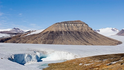
Quttinirpaaq National Park covers 37,775 km2 (14,585 sq mi) in the Northeast part of the Ellesmere Island. Quttinirpaaq National Park takes its name from a native term that means "top of the world". The easiest way to get to Quttinirpaaq National Park is to charter a plane from Resolute. But it might be kind of expansive. The plane will take up to six people with gear and will cost over $23,000 in total. But if you will get here you will see beautiful glaciers and numerous animals that are not scared of human presence. Although you might to keep your distance from animals. No body really knows what of kind of disease they might transfer if one would bite you.
First Quttinirpaaq National Park was established as Ellesmere Island National Park Reserve in 1988, but the name was changed to Quttinirpaaq in 1999, when the territory of Nunavut was created, and became a national park in 2000. Area here is dominated by rock and ice. It is a polar desert with very little annual precipitation and there are numerous glaciers. It is, by surface, the second largest park in Canada after the Wood Buffalo National Park. Plant and animal life is concentrated in the region of Lake Hazen, which due to its location has protected a milder climate than the surrounding plateaus. The park includes the Barbeau peak, which is 2,616 m and is the highest mountain in Nunavut.
Two backpacking routes are the route between Lake Hazen and Tanquary Fiord, and a loop around the Ad Astra and Viking ice caps, both approximately 100 kilometres (62 mi).
Northern Park Backcountry Excursion/Camping Permit
valid at Quttinirpaaq, Auyuittuq, Ivvavik, Nahanni, Aulavik,
Sirmilik, Tuktut Nogait and Vuntut National Parks (per person,
2018):
Daily $24.50
Annual $147.20
Fishing permit:
Daily $9.80
Annual $34.30
According to the government agency Parks Canada, which manages the national park, its area is 37,775 km². However, the International Union for Conservation of Nature (IUCN) database shows an area of 38,148 km². According to the National Parks Act of Canada, the territory of Quttinirpaak Park consists of part of Ellesmere Island, as well as part of the Arctic Ocean, bays, fjords, islands of various sizes, rivers and lakes that are located within established boundaries. The exception is Ward Hunt Island, which is planned to be included at a later date.
The park is located in the northernmost part of the Inuitian Orogen, a mountain structure that formed over a long period of time from the Precambrian to the end of the Cenozoic. These mountains are of Alpine age and are still active today. The giant mountain range, which is called the Arctic Cordillera, stretches along the northern border of the continent from the southwestern tip of Prince Patrick Island to northern Greenland. The Ellesmere-Prince Patrick Arctic Cordillera is part of the Arctic Geosynclinal Belt. The geological structure of the park territory is very diverse and is a set of polygenetic (marine, glacial, water-glacial, etc.) sedimentary rocks that form depressions or cover the flat-topped watershed parts of the massif in effusive, metamorphic and intrusive formations.
More than 65% of the park's area is located in the mountains on
Ellesmere Island, collectively known as the Grant's Land Mountains.
These mountains, the highest in the Canadian Arctic, run from northeast
to southwest and include the Osborne, Garfield, United States, British
Empire and Challenger ranges. Here, mainly at absolute altitudes of 1100
meters and above, the main glaciers of the park are located. The
position of the modern snow line varies, depending on the exposure of
the slopes, around close absolute heights (slightly lower). There is no
continuous ice sheet similar to Greenland on Ellesmere due to the
relatively low amount of precipitation. Modern glaciers occupy about 36%
of the park's area. This area of modern glaciation also includes plateau
glaciers and ice domes, which are probably up to 125 thousand years old,
as well as marine ice caps on continental shelves. The ice-free coastal
strip shows traces of more extensive Quaternary glaciation.
The
height of glaciers in the above-ground part of the park reaches 900
meters. Peaks protruding above the ice cover are called nunataks. Within
the park, a number of nunataks exceed 2,500 meters. In the mountains, at
a distance of 800 km from the North Pole, there is Barbo Peak,
protruding above the McClintock glacier, whose height is 2616 meters. It
is the highest point in the territory of Nunavut, one of the
northernmost peaks in the world, and the highest elevation in North
America east of the Rocky Mountains. North of Barbo Peak is Mount
Whisler with a height of 2590 meters (according to other sources - 2500
meters). There are no other peaks exceeding 2000 meters in the park.
The 9,250 km² Hazen Plateau is located in the southern part of the
park between the Nares Strait and Archer Fjord. The plateau drops to 300
meters in the Lake Hazen area and reaches an absolute height of about
1300 meters in the south. Currently, there is no major modern glaciation
on the plateau; only its remains remain: the Murray Ice Cap and the
Simmons Ice Cap. In the east, the plateau ends with 600-meter cliffs.
Between the Hazen Plateau and the Grant Land Mountains, Lake Hazen is
located at an altitude of about 158 meters above sea level. The
northwestern border of the lake is framed by the spurs of the Garfield
and United States ranges. With a surface area of 542 km² and a depth of
up to 280 meters below sea level, the lake is the largest Arctic lake by
volume. The basin area is 3500 km². Lake Hazen is fed by melting
glaciers around it. Part of the lake remains under ice all year round.
The Hazen Plateau is dissected by a network of ancient glacial
valleys - troughs. One of them now carries the Ruggles River, the only
watercourse that flows from Lake Hazen. The southwestern part of the
plateau belongs to the large river basin of the MacDonald River, which
flows into Tanqueri Fjord.
The marine area of the park (excluding
ice shelves) is about 2,375 km². The northern part of Ellesmere Island
was surrounded by the ice shelf of the same name, whose area at the
beginning of the 20th century was 8900 km². By 2000, the single glacier
had broken up into six isolated outlet glaciers, two of which (the Ward
Hunt and Markham ice shelves) were located within the national park. The
glaciers reach 80 meters in height and can become covered with water
during high tides.
After 2000, the Ward Hunt glacier produced
icebergs especially intensively. One of the last calvings of icebergs
occurred in the summer of 2008, when prevailing southern winds drove
pack ice away from the ice barrier and released huge polynyas. In July
2008, two large icebergs broke off from the Ward Hunt Ice Shelf, and in
August, large icebergs that broke off from the Searson Glacier west of
the park caused the destruction of the Markham Glacier. Along with this
event, the national park lost one of its unique ecosystems - an epishelf
lake, or a glacier-dammed lake. Epishelf lakes are formed from fresh
water in fjords that are completely blocked by glaciers. The lower
density of fresh water allows it to be located above the salt water, and
the glacier preserves the surface of the lake from the wind and prevents
mixing of the water. The depths of the fresh part of such lakes are
equal to the thickness of the glacial dams.
The territory of the park is an arctic desert. Cold winters feature
record temperatures for Canada, and the polar night lasts from November
to February. Summers are usually warm, especially in the Lake Hazen
area, with polar days lasting from May to August. Weather conditions in
the park are unevenly distributed, with the colder coast receiving more
rainfall compared to the interior of the island. Winds in the park are
generally weak, with the exception of ice caps. Weather changes can be
very rapid. Snow is possible at any time of the year, and visibility
sometimes disappears for several days.
Below is the climate table
for Alert. Alert is the northernmost permanent settlement in the world
and is located on Ellesmere Island a few kilometers from the park.
It is believed that the Paleo-Eskimos reached the park about 6,000
years ago. They hunted caribou and musk oxen, but they were few in
number and lived in the territory for 300–400 years. The second wave of
Paleo-Eskimos reached the island about 3,000 years ago, and the third
wave, representing the Dorset culture, about 1,000 years ago. The third
wave of Paleo-Eskimos was displaced by the Thule people, who are the
ancestors of the Inuit. The Thule hunted whales and other marine
mammals, but they also left the island during the cold snap that
occurred in 1600-1850.
In 2004, on the Ruggles River near Lake
Hazen, park staff and Inuit students discovered the remains of two Thule
dwellings, called qammaq, and other archaeological artifacts. In total,
about 200 archaeological finds related to all of the listed historical
cultures were discovered in the park, more than 40 of them are located
in the vicinity of Lake Hazen.
Europeans landed in the park in 1875, when one of the two ships of
the British Arctic Expedition led by George Nurse wintered off the
northern shores of Ellesmere Island. The HMS Discovery was stationed in
Lady Franklin Bay. The second ship of the expedition, HMS Alert, spent
the winter in Arctic waters 160 km further north. In the spring of 1876,
members of the expedition made several sleigh rides into the interior of
the island, but scurvy forced them to return to England that same year.
The next expedition to the island, which took place in 1881, also
included a stop at Lady Franklin Bay. The US Army expedition (in other
sources the expedition is called international) under the leadership of
Lieutenant Adolph Greeley set as its task the founding of a polar
scientific station, which was named Fort Conger, and work on the
international polar year program. Over two years, from August 1881 to
August 1883, about 500 observations were made, and studies of the
island's territory were carried out. During the sledding trips, Lake
Hazen and the Greeley Fjord were discovered; observations concerned the
weather conditions, tides, and the collection of various samples of
rocks, flora and fauna. However, the expedition was forced to leave the
island without receiving food supplies in 1882 and 1883. Only 7 of the
26 people, including the team leader, survived after the remnants of the
expedition became stranded on Pim Island off the east coast of
Ellesmere. They were found by the whaling ship Thetis in 1884.
The abandoned Fort Conger base was modernized in 1899, when American
explorer Robert Peary decided to use it as a parking lot. He used the
services of guides from northwestern Greenland, learned local
traditions, food and clothing, which allowed him to adapt to the harsh
climate. Robert Peary made three expeditions to the North Pole, using
Fort Conger as a staging post. After him, many other expeditions stopped
here, including international ones. Since 1991, the fort's buildings
have been under state protection.
Exploration of the territory
under the patronage of the Canadian government began in the 1920s, when
the island began to be patrolled by detachments of the North-West
Mounted Police. At this time, three posts were established on the
island. The patrols were carried out with the support of Inuit guides
from Greenland and included the territory of the future park.
Territory before the arrival of Europeans
It is believed that the
Paleo-Eskimos reached the park about 6,000 years ago. They hunted
caribou and musk oxen, but they were few in number and lived in the
territory for 300–400 years. The second wave of Paleo-Eskimos reached
the island about 3,000 years ago, and the third wave, representing the
Dorset culture, about 1,000 years ago. The third wave of Paleo-Eskimos
was displaced by the Thule people, who are the ancestors of the Inuit.
The Thule hunted whales and other marine mammals, but they also left the
island during the cold snap that occurred in 1600-1850.
In 2004,
on the Ruggles River near Lake Hazen, park staff and Inuit students
discovered the remains of two Thule dwellings, called qammaq, and other
archaeological artifacts. In total, about 200 archaeological finds
related to all of the listed historical cultures were discovered in the
park, more than 40 of them are located in the vicinity of Lake Hazen.
Europeans landed in the park in 1875, when one of the two ships of
the British Arctic Expedition led by George Nurse wintered off the
northern shores of Ellesmere Island. The HMS Discovery was stationed in
Lady Franklin Bay. The second ship of the expedition, HMS Alert, spent
the winter in Arctic waters 160 km further north. In the spring of 1876,
members of the expedition made several sleigh rides into the interior of
the island, but scurvy forced them to return to England that same year.
The next expedition to the island, which took place in 1881, also
included a stop at Lady Franklin Bay. The US Army expedition (in other
sources the expedition is called international) under the leadership of
Lieutenant Adolph Greeley set as its task the founding of a polar
scientific station, which was named Fort Conger, and work on the
international polar year program. Over two years, from August 1881 to
August 1883, about 500 observations were made, and studies of the
island's territory were carried out. During the sledding trips, Lake
Hazen and the Greeley Fjord were discovered; observations concerned the
weather conditions, tides, and the collection of various samples of
rocks, flora and fauna. However, the expedition was forced to leave the
island without receiving food supplies in 1882 and 1883. Only 7 of the
26 people, including the team leader, survived after the remnants of the
expedition became stranded on Pim Island off the east coast of
Ellesmere. They were found by the whaling ship Thetis in 1884.
The abandoned Fort Conger base was modernized in 1899, when American
explorer Robert Peary decided to use it as a parking lot. He used the
services of guides from northwestern Greenland, learned local
traditions, food and clothing, which allowed him to adapt to the harsh
climate. Robert Peary made three expeditions to the North Pole, using
Fort Conger as a staging post. After him, many other expeditions stopped
here, including international ones. Since 1991, the fort's buildings
have been under state protection.
Exploration of the territory
under the patronage of the Canadian government began in the 1920s, when
the island began to be patrolled by detachments of the North-West
Mounted Police. At this time, three posts were established on the
island. The patrols were carried out with the support of Inuit guides
from Greenland and included the territory of the future park.
In the mid-20th century, a number of research stations and military
bases were established on Ellesmere Island, including within the park.
The leading role in the construction was played by the Department of
National Security of Canada and its division, the Defense Research
Board. The Alert weather station, founded in 1950, is still operating; a
number of other camps and stations have ceased operation.
The
Hazen Lake Post (English: Lake Hazen DRB Camp) was established on the
northwestern shore of the lake in 1957-1958 as part of the International
Geophysical Year with the support of the International Council of
Science and 67 countries. The camp was engaged in glaciological research
and carried out the largest projects in the Canadian Arctic. The
original buildings still exist and serve as an observation base for the
park.
Ward Hunt Island DRB Camp was founded in 1959 by the U.S.
Air Force Terrestrial Sciences Laboratory, the Arctic Institute of North
America, and the Defense Research Commission at the height of the Cold
War and was intended to development of logistics capabilities of the
Arctic shelf in the region. 50 tons of cargo were delivered to the camp
located in the northern part of the island. In total, four barracks were
built and several tents were erected; the number of inhabitants of the
camp reached 30 people. Initial studies were related to determining the
possibility of receiving aircraft on the shelf; later, scientific
studies were carried out on the movement of the shelf, as well as the
climatic history of the region.
The Tanquary Fiord DRB Camp was
established in 1962 to coordinate research programs in the northern part
of the island. Programs were conducted in the areas of sea ice research,
as well as meteorology, oceanography, glaciology, biology and
archaeology. Research into the region based on Tanquarie Fjord continued
until the 1990s. The camp is currently used as one of the park's bases.
The harsh climatic conditions of the region have a significant impact
on the flora of the park. Permafrost thaws in summer to a depth of 10 cm
to 1 m, which does not allow plants to develop a deep root system. Low
winter and summer temperatures slow down plant metabolism and the
activity of pollinating insects. The soils are very poor, since almost
no rotting occurs in cold soil. In addition, the diversity of flora is
influenced by low precipitation and strong winds.
At the same
time, plants adapt to such conditions in a wide variety of ways. Arctic
plants are predominantly short. Thanks to the anthocyanin pigment, most
plants absorb solar energy and increase their temperature by almost 20 °
C, which is why photosynthesis occurs at lower ambient temperatures.
Some species grow in peculiar rosettes and have a hairy stem or
downy-covered seeds. While plants primarily use vegetative propagation
through stems and root systems, those same plants that are fertilized by
insects tend to place male and female flowers in close proximity to each
other. There is practically no transfer of seeds by birds and animals.
In addition, special reproduction techniques are used. Plants can wait
more than one year for conditions suitable for propagation.
Only
2% of the park is covered with vegetation. In the low areas of the park,
in the areas of Tanquarie Fjord, Lake Hazen and the shores of Lady
Franklin Bay, vegetation characteristic of tussock tundra can be found.
The park contains 154 species of vascular plants, 44 species of lichens,
and 193 species of bryophytes. The most common are polar poppy (Papaver
radicatum) and saxifrage (Saxifraga oppositifolia), which are found
almost throughout the entire snow-free territory of the park. The
tallest plant is the Arctic willow (Salix arctica), an important food
source for herbivores.