Location: Nunavut Map
Area: 22,200 km2 (8,571 sq mi)
Contact the park office +1 867-899-8092, toll-free +1-888-773-8888, or email: sirmilik.info@pc.gc.ca
Sirmilik National Park is located in Nunavut province in Canada. Sirmilik National Park covers an area of 22,200 km2 (8,571 sq mi). Sirmilik National Park was established in 2001 to protect Arctic Cordillera of the Bylot Island and surrounding lands. It is one of the most northern of the Canadian protected reserves. Indigenous Inuit tribes have settled these lands for thousands of years. Most of the area around Sirmilik National Park is still owned by these incredibly hardy and surviving people. First European explorers surveyed these area in 1610's during numerous attempts to find the Northwest passage. British explorers William Baffin and Robert Bylot surveyed and described this seemingly bare grounds. Another expedition 200 years later under leadership of the British explorer John Ross explored the lands of future lands of Sirmilik National Park in 1818.
Northern Park Backcountry
Excursion/Camping Permit valid at Sirmilik, Auyuittuq, Ivvavik,
Nahanni, Aulavik, Quttinirpaaq, Tuktut Nogait and Vuntut National
Parks (per person, 2018):
Daily $24.50
Annual $147.20
Fishing permit:
Daily $9.80
Annual $34.30
Geographically, Sirmilik National Park is divided into three parts
the Bylot Island,
the northeast of the Borden Peninsula
and an
area south of Pond Inlet between Oliver Sound and Paquet Bay.
Bylot Island
On the northeastern flank of Bylot Island, the ocean
currents of Baffin Bay and Lancaster Sound meet, causing the formation
of a long, three-pointed polynya, a "place where currents prevent the
sea from freezing over even in the harshest winters." This polynya
(Lancaster Sound Polynya) extends from Lancaster Sound around the north
and east coast of Bylot Island into Baffin Bay and north along the east
coast of Devon Island. It is the main reason why the approximately
11,000 square kilometer Bylot Island with its steep cliffs at Cape Hay
in the northwest on Lancaster Sound and around Cape Graham Moore in the
southeast at the transition from Pond Inlet to Baffin Bay is a bird
paradise became the best-known region of the national park as a bird
sanctuary, which also includes the sea within a radius of 3,200 meters.
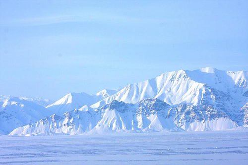
The mountainous central massif of the island of Bylot, which is up
to 2,100 meters high and forms part of the Arctic Cordillera, is almost
half covered with an ice cap, from which over 500 glacier tongues,
mostly as yet unnamed, flow down to the sea and partly in the lowlands
of the island lowlands, ends and feeds countless bodies of water in
summer. The mountain range of the Byam Martin Mountains runs across the
island from southeast to northwest. They also include the island's
highest mountain peak, the centrally located Malik Mountain at 2,100
meters. The coasts of the island, especially in the southeast, are
predominantly characterized by steep, palisade-like rocks and
seaward-migrating glaciers, but there are also flatter stretches of
coast crossed by many glacial streams, such as sections of the northeast
coast, the northwest tip and those characterized by the presence of
hoodoos well-known southwestern coastal region.
Borden Peninsula
The Borden Peninsula is an extensive plateau with a highest elevation of
around 1,380 meters. It is rugged by wide river valleys and has a bird
colony at Baillarge Bay.
Oliver Sound
Oliver Sound in the
south of Pond Inlet is a long, narrow fjord surrounded by high cliffs
and an ice and glacier region up to 1,650 meters high that extends to
Paquet Bay.
The north of Baffin Island has a polar maritime climate, which means long, cold winters and short, cool summers. Spring doesn't end until mid-June, and the warmest time is late July and early August, with average maximum temperatures of 10°C. January, the coldest month, has average maximum temperatures of around −30 °C. Rainfall is relatively plentiful, which has a positive effect on the flora.
By evaluating many archaeological excavation sites, more than 4,000
years of settlement in the area of the national park by members of the
Dorset culture and the Thule culture as well as by their successors, the
Inuit, can be proven. In the 17th century, William Baffin and Robert
Bylot penetrated Lancaster Sound. There is also evidence that Eclipse
Sound was visited by Europeans in 1820, first by William Edward Parry,
one of the more recent explorers of the Arctic. But Scottish and
American whalers must have appeared here before him; In any case, they
often hunted in the surrounding waters during the 19th century and the
beginning of the 20th century.
In 1906, Bylot Island was declared
part of Canadian territory by Captain Joseph Elzéar Bernier. For a few
years after 1910 there was a trading post at Button Point near Cape
Graham Moore, the relics of which can still be seen. This area is no
longer populated today.
The polynya on the north-eastern flank of Bylot Island offers arctic birds and marine mammals a special wealth of food, making the national park, and especially Bylot Island, the spring and summer home of a constant and rich world of seabirds; For certain species, the largest breeding colonies in the world are located here. If you also take into account the migratory movements of many land birds during spring, but especially in June, then the national park stands out as one of the most diverse bird paradises on earth. A total of more than 50 species of birds have been observed in the Bylot Island Bird Sanctuary, of which at least 30 species breed here.
The lowland tundra in the southwest of the island is home to many
species of songbirds, wading birds and waterfowl in summer (estimated
number: more than half a million). Over 100,000 Greater Snow Geese (Chen
caerulescens atlanticus) nest here; This is the largest snow goose
colony ever with around a third of the world population. The typical
arctic bird species, turnstone and white-rumped sandpiper, also come
here, and at least three bird species commonly found in Europe have been
observed here: sandy plover, red knot and wheatear.
The number of
thick-billed guillemots nesting on the palisade cliffs is estimated at
around 320,000 and that of kittiwakes at over 50,000. The species that
occur in large numbers also include black guillemots, northern petrels,
black-throated eider ducks as well as common eider ducks, glaucous
gulls, ivory gulls, arctic terns, black-headed skuas and small grebes
from the huge colonies of Lancaster Sound.
As the ice melts, the area of open water expands and provides an ideal breeding ground for algae and zooplankton. A variety of fish species benefit from this, including the numerous polar cod and the Arctic char. In this way, rich feeding grounds are created - not only for birds, but also for various seal species, such as the bearded seal and the ringed seal, which in turn serve as preferred food for many polar bears; It is estimated that around 150 polar bears stay on the island in summer. The narwhal, a goby whale, is also native to these waters. During late summer, more than half of the world's narwhals come to Koluktoo Bay on the edge of Eclipse Sound. Other marine mammals also occur in these waters, although they are relatively rare: the beluga whale, the bowhead whale, the humpback whale and the walrus.
Land mammals found in the national park include caribou, arctic foxes, arctic wolves, ground squirrels and arctic hares.
The heavily glaciated regions of the national park leave only limited
space for plant growth. However, over time, soil crumbs have developed
on terminal moraines, lateral moraines, eskers and other glacial bases,
so that not only lichens and mosses, but also vascular plants could
settle in wind-protected, ice-free zones facing the sun. This is how
plant cushions of stemless catchfly and various saxifrage plants were
created. Grasses, cotton grasses, arctic poppies and white silverwort
are also widespread, as are low shrub species such as dwarf birches,
willows and heathers.
As a result of sufficient rainfall, almost
all Arctic flora thrives in the lowlands and generally around swamps,
pools and lakes.
Sirmilik National Park is the Canadian national park with the fewest
visitors. Only six visitors were officially registered at the park in
the 2022-2023 fiscal year. However, the Quttinirpaaq National Park (7
visitors), the Tuktut Nogait National Park (12 visitors) and the Aulavik
National Park (34 visitors) did not have significantly more visitors.
What these parks have in common with very few visitors is their remote
location, sometimes very far to the north.
Access to the national
park is to the east from Pond Inlet, where the official Parks Canada
office is located. In the west, the national park can be reached from
Arctic Bay. The time between mid-April and mid-June is recommended for
ski or snowmobile tours, and the time between the end of July and the
end of August for boat and foot tours.