Location: Labrador Map
Area: 9,600 km2 (3,707 sq mi)
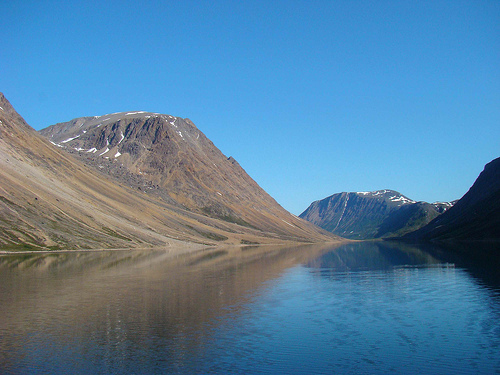
Torngat Mountains National Park, located in northern Labrador, Newfoundland and Labrador, Canada, is a remote and breathtaking wilderness area spanning 9,700 km² (3,745 sq mi). Established in 2008 as Canada’s 42nd national park, it is the first in Labrador and was created through the Labrador Inuit Land Claims Agreement (2005) and Nunavik Inuit Land Claims Agreement (2008), honoring the Inuit of Nunatsiavut and Nunavik’s deep connection to the land. Named after the Inuktitut word Tongait, meaning “place of spirits,” the park encompasses the subarctic Torngat Mountains, part of the Arctic Cordillera, and is renowned for its jagged peaks, glacier-carved fjords, polar bear populations, and some of Earth’s oldest rocks. Co-managed by Inuit and Parks Canada, it offers a unique blend of natural beauty and cultural immersion, accessible only by air, boat, or snowmobile, with just 100–600 visitors annually due to its extreme remoteness.
Torngat Mountains National Park’s history is rooted in millennia of
Inuit habitation and Canada’s evolving approach to Indigenous land
rights and conservation, culminating in its establishment as a model of
Inuit-led park management.
Inuit Homeland (Pre-Contact): For over
7,000 years, the Inuit of Nunatsiavut (Labrador) and Nunavik (northern
Quebec) have lived in the Torngat region, part of the broader Inuit
Nunangat homeland. The mountains, known as Tongait (“place of spirits”),
hold spiritual significance, with archaeological sites like tent rings,
sod houses, and burial grounds (e.g., Sallikuluk/Rose Island) evidencing
continuous use for hunting, fishing, and travel. Caribou, seals, and
Arctic char were staples, with coastal fjords and inland valleys serving
as seasonal camps. The Inuit’s semi-nomadic culture revolved around
these seasonal migrations, guided by inuksuit (stone cairns) marking
traditional routes.
European Contact (18th–20th Century): European
contact began with Moravian missionaries in the 18th century,
establishing posts like Hebron (1831–1959, now a National Historic Site
south of the park). The Hudson’s Bay Company operated trading posts in
Saglek and Nachvak fjords in the 19th century, trading furs and goods.
During World War II, a German meteorological station was installed on
Hutton Peninsula (1943) by a U-boat, and Cold War-era radar sites (DEW
Line) dotted the coast. These activities left minimal permanent impact,
preserving the region’s pristine character.
Park Establishment
(1969–2008): The idea for a national park emerged in the 1960s as Parks
Canada aimed to represent Canada’s 39 natural regions, with the Torngat
Mountains chosen for their Arctic Cordillera landscape. In the 1970s,
Newfoundland and Labrador’s provincial surveys, including those by
conservationists like Peter L. Bolger, identified the area’s outstanding
value. The Labrador Inuit Association’s advocacy led to the 2005
Labrador Inuit Land Claims Agreement (LILCA), creating the 72,520 km²
Nunatsiavut region (“our beautiful land” in Inuktitut) and designating a
9,700 km² Torngat Mountains National Park Reserve on December 1, 2005.
The Nunavik Inuit Land Claims Agreement (2008) finalized the park’s
status on July 10, 2008, ensuring Inuit co-management through an
all-Inuit Cooperative Management Board. The agreements, signed after 28
years of negotiation, were hailed as a “gift to Canada” by negotiator
Toby Andersen, allowing Inuit hunting, fishing, and trapping rights
within the park.
Modern Era: Since 2008, the park has been managed
collaboratively by Parks Canada, the Nunatsiavut Government, and Nunavik
Inuit, with the Torngat Mountains Base Camp and Research Station (opened
2010, Saglek Bay) serving as the primary access point. The park’s focus
on Inuit knowledge, ecological integrity, and low-impact tourism sets it
apart, with research on caribou, polar bears, and climate change
ongoing. The 2023 proposal for an Inuit-led national marine conservation
area (Torngats Area of Interest) aims to extend protection to coastal
waters, addressing oil, gas, and mining threats.
Torngat Mountains National Park stretches from Saglek Fjord in the
south to Cape Chidley in the north, bordering Quebec’s Nunavik to the
west and the Labrador Sea to the east, at coordinates 59°26′9″N,
63°41′47″W. Its subarctic landscape, part of the Arctic Cordillera, is
among Canada’s most dramatic and untouched.
Landscape:
Mountains and Peaks: The Torngat Mountains, an eastern extension of the
Canadian Shield, feature saw-toothed peaks, rugged barrens, and
glacier-carved valleys. Mount Caubvick (Mont D’Iberville), at 1,652 m
(5,420 ft), is the highest peak in mainland Canada east of the Rockies,
with other summits exceeding 1,538 m (5,000 ft). The range, formed 3.9
billion years ago from Precambrian metamorphic rock, is among Earth’s
oldest, with ochre, copper, and taupe striations creating a “geological
mille-feuille,” per a 2018 Smithsonian geologist.
Fjords and Coast:
Deep, ink-blue fjords like Nachvak, Saglek, and Koroc plunge from
mountains to iceberg-dotted waters, with cliffs rising 900 m from sea
level. The Labrador Sea coast, including Grenfell Sound, Eclipse
Channel, and Bears Gut, features rocky shores, shallow bays, and pingos
(ice-cored hills). Over 40 active glaciers feed streams and waterfalls,
enhancing the park’s wild beauty.
Valleys and Tundra: Lush valleys,
like the Koroc River Valley, contrast barren peaks with low brush,
willow, fireweed, and berries. The park lies above the treeline, with
alpine and Arctic tundra dominating, offering unobstructed views across
rocky barrens and green plateaus.
Climate: The subarctic climate (Dfc
Köppen) features long, harsh winters (–35 to –15°C, October–April) and
short, cool summers (5–15°C, July–September, peaking at 20°C). Annual
precipitation is 500–800 mm, with heavy coastal fog and sudden storms.
July–August, the visitor season, offers 18–20 hours of daylight, but
temperatures can drop to 0°C, and snow is possible, requiring layered
clothing and weather preparedness.
Geological Significance: The
park’s Precambrian rocks, part of the Canadian Shield, date to 3.9
billion years, formed by continental rifts exposing Earth’s mantle,
described as the planet “turned inside out” by geologists. Glacial
remnants, cirque basins, and moraines shape the landscape, with
permafrost underlying tundra, vulnerable to climate-driven thawing.
Torngat Mountains National Park’s four climatic regions—mountain
alpine, coastal fjords, southern interior valleys, and Arctic
flora—support diverse ecosystems, from boreal to Arctic species, despite
harsh conditions. Its wildlife, including polar bears and caribou, is a
conservation priority, with Inuit knowledge guiding management.
Flora:
Species: The tundra blooms with mosses, lichens, Arctic
poppies, saxifrage, and wildflowers during the brief summer
(July–August), adding color to rocky barrens. Low shrubs (dwarf birch,
willow), fireweed, and Labrador tea thrive in valleys, with boreal
patches of spruce and larch in southern interiors. The park’s ice-free
history preserves ancient plant communities, studied for climate
resilience.
Challenges: Rapid shrub growth, driven by 2–3°C warming
since 1980, alters tundra ecosystems, reducing lichen critical for
caribou. Invasive species are minimal, but permafrost thaw threatens
vegetation stability.
Fauna:
Mammals: Over 20 species include
barren-ground and Torngat Mountain caribou (calving in upper barrens),
polar bears (abundant along coasts, with healthy populations), black
bears (tundra subspecies, larger than boreal), Arctic wolves, Labrador
wolves, red and Arctic foxes, wolverines, and Arctic hares. Polar bears,
sighted frequently (often yards away, per 2018 Smithsonian), are a
highlight, with conservation programs boosting numbers. Caribou, a
species at risk, face predation and habitat shifts, with George River
herds occasionally entering post-calving.
Birds: Over 100 species,
including peregrine falcons, golden eagles, harlequin ducks (at risk),
and migratory waterfowl (snow geese, Arctic terns), nest in cliffs and
fjords. The park is a critical breeding site, with falcons spotted on
cliffs like Eclipse Channel.
Marine Life: The Labrador Sea hosts
minke whales, bearded seals, ringed seals, hooded seals, harp seals, and
harbour seals, with sea urchin colonies visible in clear waters. Arctic
char, a prized Inuit food, spawn in rivers like the Koroc, with fishing
regulated (permits required).
Challenges: Climate change disrupts
migration patterns, with warming seas shrinking ice for seals and polar
bears. Caribou and harlequin ducks are at risk from human activities
(e.g., research, tourism), mitigated by strict visitor limits
(100–600/year). Poaching is negligible due to remoteness, but boat
traffic risks marine disturbance.
Conservation Efforts: The Inuit-led
Cooperative Management Board integrates traditional knowledge,
prioritizing caribou and polar bear protection. Parks Canada’s 2023
wildlife monitoring, using cameras and Inuit observations, tracks
species health. The proposed Torngats Area of Interest marine
conservation area aims to ban oil, gas, and mining, safeguarding seals
and whales.
Torngat Mountains National Park’s extreme remoteness, with no roads,
trails, or permanent settlements, shapes its minimal infrastructure,
centered on the Torngat Mountains Base Camp and Research Station at St.
John’s Harbour, Saglek Bay, just outside the southern boundary.
Activities focus on guided wilderness and cultural experiences,
requiring significant planning.
Access:
By Air: The primary
route is via PAL Airlines from St. John’s, Gander, Deer Lake, Montreal,
or Halifax to Goose Bay, Labrador ($200–$600, daily), then a chartered
Twin Otter flight ($2,000–$5,000 round-trip) to Saglek airstrip,
followed by a boat or helicopter transfer ($500–$1,000) to the base
camp. Total travel from Goose Bay takes 2–3 hours, with charters
arranged via the base camp (1-709-635-4336, thetorngats@airborealis.ca).
Alternative charters from Nain ($1,000–$3,000) or Kuujjuaq, Nunavik, are
available. All visitors must register with Parks Canada (1-888-922-1290,
infopntorngats-torngatsnpinfo@pc.gc.ca) and attend a mandatory
orientation in Goose Bay or Nain, covering bear safety and cultural
protocols.
By Boat: Expedition cruise ships (e.g., Adventure Canada,
$5,000–$15,000, July–August) access the park via fjords, docking at
Saglek or Nachvak. Personal boats or Inuit-guided charters
($1,000–$3,000) from Nain are permitted but require registration and
bear guards.
By Snowmobile: Winter access (March–April) via
snowmobile from Nain is rare, used mainly by Inuit, requiring special
permits and extreme gear due to –35°C conditions.
Entry Fee: No park
entry fee is charged, but permits ($157.60/year for backcountry camping,
2025) and orientation are mandatory. Base camp packages ($5,000–$10,000)
cover transport, meals, and excursions.
Key Attractions:
Torngat Mountains Base Camp and Research Station: Operating mid-July to
late August, this Inuit-owned facility at St. John’s Harbour offers
platform tents, Arctic domes, meals, and guided excursions (3–7 days,
$5,000–$10,000). Accommodating 20–30 guests, it includes a cookhouse,
lounge, and solar-powered amenities, with Inuit elders, youth, and Parks
Canada staff fostering cultural exchange. Daily trips include fjord boat
tours, helicopter rides to Mount Caubvick, and hikes to waterfalls, with
2025 bookings via thetorngats.com. A 2018 Smithsonian review called it a
“safe, comfortable” gateway.
Saglek Fjord and Koroc River Valley:
Saglek Fjord’s North Arm, a summer Inuit camp for 5,000 years, offers
Arctic char fishing and polar bear sightings. The Koroc River Valley,
lush with willow and berries, is framed by jagged peaks, ideal for
hiking and photography, described as “breathtaking” in 2024 Lake.com.
Nachvak Fjord: A dramatic fjord with 1,600 m cliffs, home to polar
bears, whales, and archaeological sites. Boat tours reveal green
plateaus and Inuit grave sites, with a 2023 Adventure Canada review
noting its “sacred” feel.
Sallikuluk (Rose Island): A cultural site
with 5,000-year-old tent rings, sod houses, and a sacred burial ground
for over 600 Inuit. The 1995 repatriation of 113 remains from the
University of Toronto, as noted in 2025 National Geographic, underscores
Inuit advocacy. Guided visits with elders share its history.
Hebron
Mission National Historic Site: Just south of the park, this 1831–1959
Moravian mission site features restored wooden buildings and Inuit
history, accessible by boat or helicopter ($500–$1,000). A 2025
Tripadvisor review highlighted its “awe-inspiring” significance, with
weddings held there.
Mount Caubvick: The 1,652 m peak, Canada’s
highest east of the Rockies, is a challenging mountaineering goal,
requiring helicopter access and expert guides ($2,000–$5,000). Distant
views from fjords are popular, per 2024 Lake.com.
Northern Lights:
Winter and early fall (August–September) offer prime aurora viewing,
with clear skies showcasing vibrant displays, a “heavenly” attraction
per 2021 Adventure Canada.
Activities:
Hiking/Backpacking: No
formal trails exist, but Inuit routes marked by inuksuit guide hikers
through fjords, valleys, and tundra. Parks Canada’s route descriptions
(multi-day, single-day) cover areas like Koroc Valley and Nachvak Fjord,
requiring maps, GPS, and Inuit bear guards ($100–$200/day). Satellite
camps (5–6 pup tents, bear-fenced) support overnight hikes, with a 2023
Wikivoyage review noting their safety.
Boating/Kayaking: Fjord tours
by Zodiac ($200–$500/day) explore whales, seals, and icebergs, with
kayaking ($100–$200/day) in calmer bays. Inuit guides share spiritual
stories, per 2025 Parks Canada.
Wildlife Viewing: Polar bears,
caribou, wolves, and falcons are frequent, with binoculars essential. A
2018 Smithsonian visitor counted multiple bears in four days, often
“yards away.” Guided tours ($200–$500) ensure safety.
Fishing: Arctic
char fishing in rivers like Koroc requires permits (1–2/day limit),
supporting Inuit traditions. Guided trips ($100–$200) teach techniques,
per 2023 Global National Parks.
Cultural Experiences: Inuit elders at
base camp share stories, games, and meals (e.g., Arctic char, bannock)
over open fires, with 2025 National Geographic praising their “profound”
connection to the land. Visits to Sallikuluk and Hebron deepen cultural
understanding.
Photography: Fjords, peaks, and auroras yield “tourist
brochure” shots, per 2023 Global National Parks. Helicopter tours
($500–$1,000) capture Mount Caubvick’s grandeur.
Amenities: Base camp
offers tent/dome accommodations, meals (accommodating diets), showers,
and a lounge, with no cell service but satellite communication for
emergencies. Backcountry camping requires self-sufficiency (bear-proof
containers, water filters). Waskesiu’s amenities (ATMs, Wi-Fi,
restaurants) are absent, with Goose Bay or Nain as staging points for
supplies.
Torngat Mountains National Park is a cornerstone of Inuit identity
and Canada’s reconciliation efforts, blending spiritual, cultural, and
ecological values.
Inuit Heritage: As part of Nunatsiavut (“our
beautiful land”), the park is a living homeland for Labrador and Nunavik
Inuit, who have hunted, fished, and camped here for 7,000 years. The
Tongait name reflects its spiritual role, with sites like Sallikuluk’s
burial ground and inuksuit routes embodying cultural continuity. The
Inuit-led Cooperative Management Board ensures traditional knowledge
shapes park decisions, a model praised in 2025 National Geographic for
honoring Inuit rights.
Reconciliation: Established via the 2005 and
2008 land claims, the park is a “gift to Canada,” per negotiator Toby
Andersen, fostering understanding of Inuit culture. Programs like base
camp’s elder-youth exchanges (5,000 participants since 2010) and the
1995 repatriation of Inuit remains from Sallikuluk highlight
reconciliation, though historical displacements (e.g., Hebron’s 1959
closure) remain sensitive, per 2025 Parks Canada.
Community Impact:
The park supports Nain (population 1,200) and Nunavik communities
through jobs as guides, cooks, and bear guards (50–100 seasonal, median
income ~$25,000). Tourism generates $1–2 million annually, but high
costs limit local economic benefits. The Nunatsiavut Government
reinvests in education and heritage, per 2023 The Narwhal.
Global
Significance: As Atlantic Canada’s largest and most remote national
park, Torngat’s 3.9-billion-year-old rocks, polar bear populations, and
Inuit co-management draw researchers and adventurers. Its proposed
marine conservation area could set a global precedent, per 2023 The
Narwhal.
Torngat Mountains National Park’s remoteness and ecological fragility
pose unique challenges, reflecting broader Arctic conservation issues.
Remoteness and Access: Accessible only by costly air ($2,000–$5,000)
or boat ($1,000–$15,000), with just 100–600 visitors annually, the park
is exclusive, as a 2023 Planet D review noted it’s “harder to reach than
Australia.” Weather delays (fog, storms) strand visitors, with 2025
Parks Canada warning of schedule changes. Limited flights from Goose Bay
(1–2 daily) and no roads restrict access, costing $1–2 million in
potential revenue.
Wildlife Threats: Climate change, warming 2–3°C
since 1980, shrinks sea ice for polar bears and seals, while shrub
growth reduces caribou lichen, per 2023 The Narwhal. Human activities
(e.g., research, cruises) risk disturbing at-risk species like harlequin
ducks, mitigated by visitor caps and bear guards. Polar bear encounters
(10–20/year) require armed escorts, adding costs ($100–$200/day).
Environmental Strain: Permafrost thaw destabilizes tundra, impacting
archaeological sites and trails. Cruise ship emissions and boat traffic
threaten marine life, with 2023 The Narwhal urging stricter regulations.
Litter is minimal due to low visitation, but fuel spills from charters
are a concern, per 2025 Parks Canada.
Cultural Preservation:
Balancing tourism with sacred site protection is delicate, with
Sallikuluk’s burial ground vulnerable to disturbance, per 2025 National
Geographic. The Inuit-led board mitigates this, but funding
(~$500,000/year) limits site restoration. Historical traumas, like
Hebron’s forced relocation, require sensitive interpretation, per 2023
Parks Canada.
Management Issues: Parks Canada’s budget (~$1
million/year) and small staff (10–15 in Nain) strain monitoring across
9,700 km². The 2025 research permit deadline (March 1) delays studies,
per Parks Canada. Enforcement of no-firearms and bear-guard rules is
rigorous but resource-intensive, with a 2023 Tripadvisor review noting
bear-related hike cancellations.
Equity Concerns: High costs
($5,000–$15,000/trip) exclude most Canadians, including Inuit outside
Nain, despite no entry fee. Economic benefits favor tour operators over
locals (median income ~$20,000), per 2023 The Narwhal. Expanding
Inuit-led guiding could address this, but training is underfunded.
Strengths:
Pristine 9,700 km² of fjords, peaks, and
3.9-billion-year-old rocks.
Healthy polar bear populations and
diverse wildlife (caribou, whales, falcons).
Inuit-led management, a
global model for Indigenous conservation.
Exclusive base camp
experiences with cultural immersion.
Opportunities:
Develop
the proposed marine conservation area for global impact.
Expand
Inuit-led tours and youth programs for economic equity.
Promote
virtual tours or exhibits to broaden access.
Leverage research (e.g.,
caribou, permafrost) for climate solutions.
Torngat Mountains National Park offers an unparalleled Arctic
adventure, centered on the Torngat Mountains Base Camp (mid-July–late
August, $5,000–$10,000, 3–7 days), with guided hikes, fjord tours, and
Inuit cultural experiences. Its extreme remoteness demands planning and
resilience.
Highlights:
Base Camp: Platform tents or Arctic
domes, with meals (Arctic char, bannock), showers, and cultural talks by
Inuit elders, create a “profound” experience, per 2025 National
Geographic. Daily excursions (hiking, boating, helicopter rides) explore
fjords and peaks, with a 2018 Smithsonian review noting “no panic”
during a polar bear sighting due to expert guides.
Nachvak and Saglek
Fjords: Zodiac tours ($200–$500) reveal whales, seals, and cliffs, with
a 2023 Adventure Canada review calling Nachvak “paradise.”
Sallikuluk
and Hebron: Cultural visits with Inuit guides ($100–$200) share
5,000-year-old history, described as “life-changing” in a 2025
Tripadvisor review.
Koroc River Valley: Hikes through lush valleys
with caribou and waterfalls, a “lush” contrast to barren peaks, per 2024
Lake.com.
Northern Lights: August–September auroras, visible from
base camp, are “heavenly,” per 2021 Adventure Canada.
Activities:
Hiking/Backpacking: Inuksuit-guided routes (no trails) range from day
hikes (5–10 km) to multi-day treks, requiring maps, GPS, and bear
guards. Satellite camps support overnight camping ($200–$500/night),
with a 2023 Wikivoyage review praising safety.
Boating/Kayaking:
Fjord Zodiac tours ($200–$500) and kayaking ($100–$200) offer marine
wildlife views, with Inuit stories enhancing the experience, per 2025
Parks Canada.
Wildlife Viewing: Polar bears, caribou, and falcons are
frequent, with a 2023 Tripadvisor review noting a 10 km hike halted by
black bears, requiring guards.
Fishing: Arctic char fishing
($100–$200, permits required) in rivers like Koroc, guided by Inuit, per
2023 Global National Parks.
Photography: Fjords, peaks, and auroras
yield “world-class” shots, with helicopter tours ($500–$1,000) to Mount
Caubvick, per 2023 Global National Parks.
Tips:
Best Time:
Mid-July–late August for milder weather (5–15°C) and 18–20 hours of
daylight. September offers auroras but risks snow/fog, per 2025 Parks
Canada.
Essentials: Bring layered clothing (–5 to 20°C), waterproof
gear, binoculars, bear spray (guards carry firearms), and cancellation
insurance (weather delays common). Modest attire respects Inuit hosts.
Register permits and attend orientation in Goose Bay/Nain.
Safety:
Polar and black bears require armed Inuit guards ($100–$200/day);
firearms are banned for visitors. Weather changes (fog, storms) delay
flights, with a 2025 Parks Canada warning of stranding risks. Emergency
rescue is limited (helicopter-based, Nain).
Planning: Book base camp
6–12 months ahead (20–30 slots, 5 weeks/year) via
thetorngats@airborealis.ca. Arrange charters and permits through Parks
Canada (1-888-922-1290). Cruises (Adventure Canada, $5,000–$15,000)
simplify logistics but limit hiking. A 2025 Tripadvisor review
recommended helicopter tours ($500–$1,000) for “worth it” views.
Visitor Feedback: 2025 Tripadvisor and National Geographic reviews rate
Torngat 4.8/5, praising “spectacular” fjords, “awe-inspiring” Inuit
culture, and polar bear sightings, with a 2023 user calling it
“university on water” for its expert guides (photography, archaeology).
Complaints include high costs ($5,000–$15,000), bear-related hike
cancellations, and weather delays, with a 2023 review noting “pricey
even for Labradorians.” X posts from 2016–2019 highlight its “raw
beauty” and “untamed” spirit, reflecting enduring allure.