Location: Alberta Map
Area: 505 km²
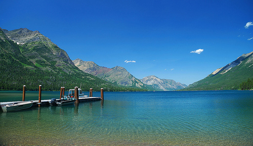
Waterton Lakes National Park is located in Alberta province in Canada, near the border with Montana, United States. Waterton was the fourth national park of Canada, created in 1895 and named in such a way by Lake Waterton. Waterton Lakes National Park covers an area of 505 km². The park offers a wide network of hiking trails. You can also take it to the back country camping. You need a camping permit for $10 a night or buy an annual pass for $68.70. Additionally there are several camping grounds on the territory of the Waterton Lakes National Park.
Waterton Lakes National Park is managed by Parks of Canada, Waterton is open all year, but the main tourist season is during the months of July and August. The only commercial facilities available in the park are in the town of Waterton Park. The park goes from an elevation of 1,290 m, in the town, to 2,910 m on Mount Blakiston. It offers many picturesque trails, including Lake Crypt. In 1979 it was named a Biosphere Reserve and in 1995 a World Heritage Site as part of the Waterton-Glacier Peace International Park.
Waterton Lakes National Park covers an area of 505
km² (195 sq mi), about the size of the Island on Montreal.
Waterton is open all year, but the main tourist season is during
July and August. The only commercial facilities available within the
park are located at the Waterton Park townsite. The park ranges in
elevation from 1,290 metres (4,232 ft) at the townsite to 2,910 m
(9,547 ft) at Mount Blakiston. It offers many scenic trails,
including Crypt Lake trail. In 2012/2013, Waterton Lakes National
Park had over 400,000 visitors.
Contact the park office +1
403-859-5133, toll-free: 1-888-773-8888 or email:
waterton.info@pc.gc.ca
Belly River Campground
off the highway 6
Open: mid- May- mid- Sept
Entrance Fee: $15.70 a night
First
come, first served basis
Crandell Mountain Campground
Red
Rock Parkway, 6 km South of Highway 5 intersection
Open: mid-
May- Labor Day
Entrance Fee: $21.50
First come, first served
basis
Townsite Campground
Windflower Rd
Open: mid-
April- mid- Oct
Entrance Fee: $38.20/ $27.40 (serviced site/ not-
serviced site)
There is no fee to enter the park if you are just
driving through along Highway 6. However, if you want to do any
activities, visit the townsite or stay overnight, a daily fee will
apply. The fee is paid at the gatehouse on Highway 5, on the road to
Waterton townsite, just after its junction with Highway 6.
If
staying for a week or more, the annual park pass is a good value,
though it can only be used in Waterton. An annual Discovery Pass can
also be purchased for a higher fee and be used in Waterton and at
the nearby Banff National Park, Jasper National Park, and many other
national parks and historic sites.
Daily fees summer/shoulder
season (2018):
Adult $ 7.80/$ 5.80
Senior $ 6.80/$ 4.90
Children and youth under 18 free
Family/group $ 15.70/$ 11.75
Annual (2018):
Adult $ 39.20
Senior $ 34.30
Children and
youth under 18 free
Family/group $ 78.50
Fishing permit
(2018):
Daily $ 9.80
Annual $ 34.30
Parks Canada Passes
The Discovery Pass provides unlimited admission for a full year at
over 80 Parks Canada places that typically charge a daily entrance
fee It provides faster entry and is valid for 12 months from date of
purchase. Prices for 2018 (taxes included):
Family/group (up
to 7 people in a vehicle): $136.40
Children and youth (0-17):
free
Adult (18-64): $67.70
Senior (65+): $57.90
The
Cultural Access Pass: people who have received their Canadian
citizenship in the past year can qualify for free entry to some
sites.
The park takes its name from a series of three lakes that were named by Lieutenant Thomas Blakiston, during the Palliser Expedition (1857 to 1860), in honor of Charles Waterton (1782-1865), a naturalist and English explorer.
The park is located in the southwest corner of Alberta, 270 km south
of Calgary and 130 km southwest of Lethbridge. Its western and southern
boundaries follow the borders of British Columbia and the State of
Montana (United States), respectively. The park is bordered to the south
by Glacier National Park, to the east by Akamina-Kishinena Provincial
Park (British Columbia). From the point of view of the municipal
administration, the park is entirely located in Improvement District No.
4. The park is crossed by provincial roads 5 and 6.
In the 2006
census, the park had a population of 160 inhabitants
Located in the Rocky Mountains, the park belongs to the Clark Range, the southernmost mountain range of the Rockies in Canada. Elevation in the park ranges from 1,280 m at the outlet of the Waterton River to 2,904 m at the summit of Mount Blakiston. The park is connected to British Columbia by three mountain passes, Akamina Pass (1,799 m), South Kootenay Pass and Sage Pass. Unlike Glacier Park, Waterton does not contain any glaciers.
The oldest rocks in the park are marine sediments dating back 1.5
billion years. These rocks are composed of limestone, dolomite and
igneous rocks. We observe fossilized seabeds as well as salt
pseudomorphoses. There are numerous stromatolite formations dating back
1.3 billion years.
Unlike the Canadian Rockies, whose sedimentary
strata are more or less inclined, the Waterton sediments are
characterized by a single thrust. The Lewis thrust allowed Proterozoic
sediments to move as a single block in a more or less horizontal manner
over Cretaceous rocks dating back about 70 million years for a distance
of 100 km to the southeast. The fact that older rocks are found on
younger rocks is a rare phenomenon in geology. Beneath the Proterozoic
layer, we find a layer dating from the Upper Cretaceous which is
composed mainly of schist.
Although no glaciers remain in
Waterton, apart from a few patches of perennial snow, the landscape has
been greatly shaped by the Wisconsin glaciation. The park has numerous
glacial valleys, hanging valleys, ridges, cirques, kames and eskers.
Since the end of the last glaciation, the Cameron and Blakiston rivers
have formed two alluvial fans at their mouths. The village of Waterton
is also built on one of them.
Waterton's climate is the wettest in Alberta. Precipitation amounts to 1,072 mm per year. Despite its small size, the park experiences strong variations in rainfall. Precipitation drops from 1,520 mm at Cameron Lake to only 760 mm per year at the park entrance. This is particularly due to the presence of the Rocky Mountains which block moisture from the Pacific Ocean. Summers in the park are short and cool and winters long and mild. During the winter season, temperatures can rise up to 10°C during Chinooks, making it one of the warmest places in Alberta. However, the temperature can drop to −40°C.
Waterton has 100 km of rivers and 80 lakes and ponds. These flow by two rivers, the Waterton and the Belly, both of which flow into the Saskatchewan River and then into the Nelson River. The Waterton River collects the waters of two-thirds of the park, including those of the main lakes, namely Lakes Maskinongé, Cameron, Waterton Inférieur, Waterton Middle and Waterton Supérieur. The United States border ultimately crosses Cameron and Waterton Superior lakes.
There are 250 archaeological sites in the park, the oldest of which
date back 11,000 years. Between 10,000 and 1,600 years before present,
the park's inhabitants diversified into two social modes, one based on
bison hunting and the other on the practice of hunting, fishing and
gathering. Between 1600 and 200 BCE the territory was divided between
the Kootenays who lived west of the Continental Divide and the Blackfoot
Confederacy east of it. The appearance of the horse, between 1725 and
1800, greatly changed the geopolitical balance and hunting techniques.
It had the effect of definitively driving the Kootenays from the plains
in favor of the Blackfoot. The fur trade began at the beginning of the
19th century. The arrival of surveyors, soldiers and European settlers
ended the way of life of the Native Americans, who were moved to Indian
reservations. The last Waterton bison disappeared in 1879.
The
Palliser expedition visited the region between 1857 and 1860. Between
1858 and 1861, a joint commission from Great Britain and the United
States marked the boundary at the 49th parallel. The North-West Mounted
Police mounted an expedition to the region in 1874 to eliminate whiskey
smuggling and established a post at Fort Macleod. The region was divided
into lots for settlement during the 1880s; the first settlers were
demobilized mounted police officers.
In 1893, a Pincher Creek rancher, F.W. Godsal, recommended that the
government establish a national park in the Waterton Lakes area. On May
20, 1895, the federal government created the 139.91 km2 "Kootenay Forest
Park" in the Waterton Lakes region.
In 1902, Western Canada's
first oil deposit was discovered in the Cameron Valley. Its production
was 300 barrels per day. In 1904 the Western Coal and Oil Company of
Vancouver found another well producing one barrel per day. The company
was also responsible for the creation of the village of Waterton Park,
where it installed an administrative office, a site kitchen, a barracks,
a forge, a stable and an engine room.
In 1910, the village was
divided into 150 lots and the land was rented at $15 per year for land
bordering the lake and $10 for the others. The park changed its status
and was renamed “Waterton Lakes Dominion Park” in 1911. Its area was
reduced to 33.68 km2. The first two businesses in town are a hotel and a
stable. That same year, Great Northern Railway President James Hill had
a vision to make Waterton and Glacier Lakes Park (which was established
that same year) the "playground of the Northwest." He then began with
his son Louis to build infrastructure – hotels, roads, chalets and
trails – to develop tourism in the park. Louis Hill visited the Waterton
area in 1913 and selected a site overlooking Upper Waterton Lake to
build a hotel. The area of the park increased to 1,095 km2 in 1914 and
was reduced to only 570 km2 in 1921.
On February 1, 1926, the
government handed over management of the park to the Canadian Rockies
Hotel Co. Ltd, a subsidiary of the Great Northern Railway for 42 years.
It undertook the construction of the Prince of Wales Hotel, inaugurated
the following year. The hotel is one of the great survivors of the
resort hotels developed by the railway networks of Canada and the United
States. It was recognized as a national historic site in 1995. A
250-passenger ship, the M.V. International, was also built that same
year, which navigated the waters of Upper Waterton Lake. The ship is
still in service there.
The village also experienced strong
development and in 1931 it had most of the modern infrastructures of the
time: a garage, a golf course, a tennis court, a campsite, a post
office, hotels, a hall dance hall, a pharmacy, two butcher shops, five
restaurants, two churches, a Royal Canadian Mounted Police station, a
swimming pool, a school, a playground, telephone service and several
summer cottages. Between 1947 and 1954, the park underwent several minor
reductions to its current size.
The desire for cooperation between Waterton Lake Park and Glacier was
evident from the creation of the American park in 1910. It was first
proposed by the first official of Waterton Lake Park, John George Brown,
and the American ranger Henry Reynolds. However, it was not until 1931
that the Rotary Clubs of Alberta and Montana unanimously adopted the
creation of the Waterton-Glacier International Peace Park at a meeting
at the Prince of Wales Hotel. Following pressure from the clubs on
elected officials, the agreement was ratified by an American law on
April 25, 1932 and a Canadian law on June 16, 1932.
In 1979, the
Waterton biosphere reserve encompassing the park was recognized by
UNESCO as the second biosphere reserve in Canada, after that of Mont
Saint-Hilaire, in Quebec. It thus adjoins that of Glaciers, located in
the United States. In 1995, Waterton-Glacier International Peace Park
was recognized as a World Heritage Site.
There are 971 species of vascular plants and 349 species of
vertebrates found in the park. Contact with the prairies, which are very
close, contributes to the richness of the fauna and flora of Waterton,
which are not found further north or further south of the Rocky
Mountains.
There are still some rare species found in the park.
Among the list of the Committee on the Status of Endangered Wildlife in
Canada, we find an endangered species, the half-moon hairstreak
(Satyrium semiluna), a butterfly. Seven species are also considered
threatened: the plains bison (Bison bison bison), the ferruginous hawk
(Buteo regalis), the common nighthawk (Chordeiles minor), the Bolander's
quillwort (Isoetes bolanderi), the olive sides (Contopus cooperi),
Sprague's pipit (Anthus spragueii) and cutthroat trout (Oncorhynchus
clarkii). Seven other species are considered of concern: the wolverine
(Gulo gulo), the long-billed curlew (Numenius americanus), the western
toad (Bufo boreas), the peregrine falcon (Falco peregrinus), the
northern leopard frog (Rana pipiens), the short-eared owl (Asioflammeus)
and the grizzly bear (Ursus arctos).
The park is part of the
Canadian Rockies ecoregion according to the ecological framework of the
Commission for Environmental Cooperation. In addition to this park, the
ecoregion includes the American Glacier National Park, and the Canadian
national parks of Banff, Kootenay, Yoho and Jasper.
Like several other mountain parks, Waterton Lakes has several layers
of vegetation. At the lowest, between 1,280 and 1,500 m, we find the
parkland of the foothills. This ecoregion is mainly composed of Altai
fescues (Festuca altaica), interspersed with groves of trembling aspen
(Populus tremuloides).
A little higher than the park forest is
the mountain level which goes from 1,280 to 1,680 m. It is composed of
wheatgrass meadows (Pseudoroegneria spicata) and poplar forest (Populus
sp.), Douglas fir (Pseudotsuga menziesii), limber pine (Pinus flexilis)
and lodgepole pine (Pinus contorta).
The subalpine level is
divided into two parts. The lower part, which is between 1,650 and 1,950
m, is composed of Engelmann spruce (Picea engelmannii) and subalpine fir
(Abies lasiocarpa). The upper part, which is located between 1,950 and
2,250 m, is mainly composed of whitebark pine (Pinus albicaulis) and
subalpine larch (Larix lyallii).
Above 2,250 m is the Alpine
stage. This level does not have a forest and is composed of reticulated
willow (Salix reticulata), slender cinquefoil (Potentilla gracilis),
stemless campion (Silene acaulis), whole-leaved dryad (Dryas
integrifolia), viscid polemony (Polemonium viscosum ) and many species
of lichens.
The park is frequented by 60 species of mammals. Ungulates include
elk (Cervus canadensis), moose (Alces americanus), mule deer (Odocoileus
hemionus), white-tailed deer (Odocoileus virginianus), Canadian bighorn
sheep (Ovis canadensis), and mountain goats. (Oreamnos americanus). The
park also has a small population of North American bison (Bison bison)
in enclosures. On the carnivore side, the park is one of the few places
in North America where all native carnivores have survived. There we
find, among others, the grizzly bear (Ursus arctos), the black bear
(Ursus americanus), the cougar (Puma concolor), the Canadian lynx (Lynx
canadensis), the bobcat (Lynx rufus), the wolf (Canis lupus ), the
coyote (Canis latrans) and the river otter (Lontra canadensis)26. Small
mammals include the Columbian ground squirrel (Spermophilus
columbianus), striped ground squirrel (Spermophilus tridecemlineatus),
golden-mantled ground squirrel (Spermophilus lateralis), gray gopher
(Thomomys talpoides), red squirrel (Tamiasciurus hudsonicus) , the
red-tailed chipmunk (Tamias ruficaudus), the northern chipmunk (Tamias
amoenus), the lesser chipmunk (Tamias minimus), the snowshoe hare (Lepus
americanus), the American pika (Ochotona princeps), the Rocky Mountain
marmot ( Marmota caligata), the yellow-bellied marmot (Marmota
flaviventris) and the Canadian beaver (Castor canadensis). There are
also several species of bats, including the little brown bat (Myotis
lucifugus), the big brown bat (Eptesicus fuscus), the long-eared bat
(Myotis evotis), the long-eared bat legs (Myotis volans), and the
silvery bat (Lasionycteris noctivagans).
There are 255 species of
birds observed in the park. Among these, there are 37 permanent
residents and 149 who nest there. Among the waterfowl, we find the
tundra swan (Cygnus columbianus), the cinnamon teal (Anas cyanoptera),
the northern shoveler (Anas clypeata), the hooded merganser (Lophodytes
cucullatus) and the Canada goose (Branta canadensis). Among the birds of
prey, we find the bald eagle (Haliaeetus leucocephalus), which nests in
the park. The Sandhill crane (Grus canadensis) is also found there as a
nesting bird. There are 60 species of passerines, including the greenish
warbler (Vermivora cecita), the bush warbler (Oporornis tolmiei), the
red-breasted nuthatch (Sitta canadensis), the brown-capped titmouse
(Poecile hudsonica), the brown finch (Leucosticte arctoa), Brewer's
Sparrow (Spizella breweri) and Rock Wren (Salpinctes obsoletus). We also
find the three-toed woodpecker (Picoides tridactylus) and the
white-tailed ptarmigan (Lagopus leucura) in the park.
There are
only four species of reptiles that frequent the park, namely the gopher
snake (Pituophis melanoleucus), the western snake (Thamnophis elegans),
the Plains snake (Thamnophis radix) and the garter snake (Thamnophis
siralis). ). There are also six species of amphibians: the boreal chorus
frog (Pseudacris maculata), the northern leopard frog (Rana pipiens),
the Columbia spotted frog (Rana luteiventris), the western toad (Bufo
boreas) , the long-toed salamander (Ambystoma macrodactylum) and the
tiger salamander (Ambystoma tigrinum).
There are 24 species of
fish in the park. Among these, we observe the bull trout (Salvelinus
confluentus), the lake trout (Salvelinus namaycush) and the northern
pike (Esox lucius) as native species and as introduced species the
rainbow trout (Oncorhynchus mykiss). , brook trout (Salvelinus
fontinalis) and sea trout (Salmo trutta).
The biodiversity of the park is considered good and stable. However,
10% of the plant species present in the park are not native. Among these
species, the most threatening is probably blister rust which attacks
whitebark pine (Pinus albicaulis), a species which has no natural
protection against this disease. In 2003, 71% of the pines present in
plots were infected and 53% of these were dead.
Fire suppression
and the disappearance of bison also contributed to the expansion of
aspen forests on fescue prairies. The proportion of meadows has
decreased over that of forest by 373 ha in 110 years, including 47% in
favor of trembling aspen.
Because of these threats and following
data collected after a fire that destroyed 1,521 ha in 1998, Parks
Canada developed a controlled burning program and allows naturally
caused fires that do not threaten park infrastructure to progress. The
agency thus caused a fire of 1,400 ha in the meadow in 2006. The fires
make it possible, among other things, to create a forest mosaic allowing
greater resistance to diseases, as well as to get rid of dead grass
which harms the fescue. of Altai.
The park is administered, from Waterton Park, by Parks Canada, an
agency of the Department of the Environment Canada. For the 2011-2012
fiscal year, the agency has a budget of $696 million to manage 42
national parks, 956 national historic sites — including 167 managed
directly by the agency — and four national marine conservation areas.
Established in 1911 as the Dominion Parks Division, Parks Canada was
the first national park service in the world. Since 1930, the National
Parks Act has prohibited mining exploration and exploitation as well as
logging in parks. In 1970, Parks Canada adopted a plan for the creation
of new national parks based on the representativeness of the physical,
biological and geographical characteristics of the 39 terrestrial
regions of Canada. Currently, 28 of the 39 terrestrial regions, or 70%
of the network, are represented by a national park.
There were
148 employees in Waterton Lakes who worked for Parks Canada in 2004. Of
this number, only 41 worked year-round. The operating budget was
$4,104,000 in 2003.
The park is visited annually by approximately 400,000 visitors, which is far lower than Banff National Park, which is visited by more than three million visitors2 making it the most visited park in Canada. It is also much less visited than Glacier National Park, which received 1.8 million visitors. In 2005, 46% of visitors came from Alberta, 37% from the United States and 9% from other Canadian provinces. Statistics show that a good portion of Americans visiting the park do so in tandem with Glacier National Park. The majority of repeat visitors are Albertans and only visit Waterton Lakes. The park is open all year round, however only the village region is accessible in winter.
The park is accessible by Provincial Highways 5 and 6, which connect
Waterton to Pincher Creek and Cardston to the north. Glacier National
Park is accessible by the Mont-Chief International Highway, which
bypasses the latter from the east. In addition to accessing the village,
two roads provide access to the mountains to the west and the Akamina
and Red Rock Parkways.
In terms of accommodation, the park has 10
hotels, all located in the village, as well as three developed campsites
offering a total of 391 sites. The backcountry also has nine rustic
campsites accessible only by trails.
The park has 14 picnic
areas. It is covered by more than 200 km of hiking trails, offering a
choice for lovers of short and long hikes. The trails provide access to
Glacier and Akamina-Kishinena parks. The park also has 24 km of mountain
bike trails.
Horseback riding, swimming, rock climbing, boating
(as well as motorized boating), fishing, golf, tennis and scuba diving
are also possible. In winter, visitors can enjoy snowshoeing, skiing and
glacier climbing.
In addition to Glacier National Park and Akamina-Kishinena Provincial Park, a few protected areas are located within a 50 km radius of Waterton Lakes National Park. These include Police Outpost, Beauvais Lake and Castle Provincial Parks, Castle Wilderness Provincial Park, Outpost Wetlands Natural Area, West Castle Wetlands Ecological Reserve and Payne Lake Provincial Recreation Areas. and Waterton Reservoir.