Location: Coba, 44 km North- West of Tulum, Quintana Roo Map
Coba is a large archeological complex of the Mayan civilization dating back to Pre- Columbian period. It is located in the state of Quintana Roo 90 km east of another Mayan site of Chichen Itza and 44 km northwest of the site of Tulum. You can to Coba Archaeological Site either by bus with the tourist group or by renting a car. Modern asphalted road leads to the city. You can take either road 180 to Nuevo Xcan and turn south to Coba or highway 307 that goes along the coast. Around Tulum smaller northwest road will lead you to the site. Roads 180 and 307 are well maintained highways. Smaller roads however have more potholes and bumps so drive slowly. Besides running kids and dogs might jump on the road unexpectedly.
Coba is situated between Coba and Macanxoc Lakes. It is prohibited to swim here due to large number of crocodiles that live here. But if you want to feed these reptiles it won't be a problem. You can approach them fairly closely using wooden bridges that allows fairly close contact with the reptiles. Much of the city buried underneath a heavy foliage of a jungle. Several groups are connected by roads or sacbe (plural sacbeob). These are largely covered by growing rain forest.
You can rent a bike or a rickshaw on a bike at the entrance of a Coba archaeological site. This is probably the quickest way to get around the massive city.
Coba is one of the oldest and largest Mayan settlements on the Yucatan peninsula. Sizeable agricultural population was established around second century BC. Coba reached its population peak during Late Classic period (600- 900 AD) then Coba became one of the largest cities on Yucatan. Unfortunately only small portion of the ancient city has been uncovered and work continues to this day. But based on current digs archaeologist speculate that this could be the largest metropolis on the peninsula. By rough estimates the city population was around 100,000 inhabitants with 6,500 structures covering the area of 80 square km.
During the Post Classic period (1000- 1200 AD) Coba lost its dominance to cities like Tulum. The city crumbled as a political and commercial centre. The most likely reason for such significant decline was ecological disaster. Growing populations could not be fed by dwindling farms. Despite heavy foliage jungle reddish soil is devout of organic matter thus making its productivity fairly low. Agricultural collapse probably led to starvation and eventually to plagues that killed majority of population that did not leave the city. However archaeological evidence give indication that people still lived there. Temples and important religious sites were repaired and rebuild until at least 14th century, probably as late as Spanish arrival in the region.
The site was relatively obscure for the scientific community, although the whereabouts were never lost by the locals. Amateur explorer Dr. Thomas Gann visited the site in February 1926 guided by the local Maya hunter. He published his first- hand experience on the site. This information allowed first scientific expedition was sent by Carnegie Institution under leadership of J. Eric S. Thomson. With the building of the first modern road in 1970’s a new interest in the site began. Since then archeological digs are still going on.
Coba is largely undiscovered for archeologists. Much of the city is still buried by the thick jungle. Uncovered ruins is a complex of 5 groups. In order to get from one to the other tourists walk through shady, well marked trails that connect these sites. If you don't want to take a hike around forests you can take a bike a rickshaw at the entrance. It would speed up the exploration of the building groups. Coba is especially beautiful early in the morning then visitors did not scare most of the wildlife. Jungle canopy is full of birds, monkeys and other animals that fill the forest with sounds and commotion.
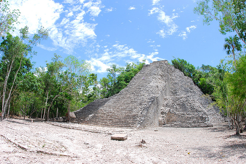
The tallest pyramid in the city is Nohoc Mul (Mayan word for “Large hill”). It is also sometimes referred as the Grand Pyramid of Coba or El Castillo ("The Castle"). Rising at 42 meters (138 feet) it is tallest pyramid on the Yucatan peninsula. Visitors take 120 steps to the top of the structure. Going up is fairly difficult since the temple is unusually steep and was not repaired for centuries. However going down is the real challenge. Hold on to the ropes to avoid accidents. At the top of the pyramid small temple crowns the magnificent structure with an altar probably used for sacrifices. Beautiful panorama of the jungles was probably the last thing that victims saw before their beating heart was ripped from their thoracic cavity. Two carvings on the temple over the door entrance are referred to as “Giving God”.
Coba has at least two ball courts that were used by the Mayans for their ritualistic games. Two groups of men faced each other on the court. Each team had to score a rubber ball through the narrow hoop. The only parts of the body they could use to kick the ball were elbows and hips. Sacrifice was almost certainly part of the game. However we don't know whether captain or the whole team was killed. Additionally they is certain degree of debate whether it was the winners or losers who got the "honor".
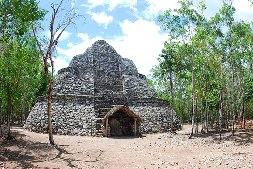
Templo de la Iglesia (Temple of the Church) is second in height in the city. From the top of the pyramid there is a view of lake Macanxoc to the east and lake Coba to southwest of the pyramid.
Ritual roads or Sacbe were used by the Mayans for religious processions as well as transportations. It was constructed from the local limestone. There are about 50 Sacbe in the area. Mayan roads disserve special praise. Some of them were over 62 miles (100 km) long and 10 to 30 ft wide. Each road was constructed out of stones to a height of 3- 7 ft (1-2 m) and then covered with white mortar. Most of the road network are hidden by the jungle. Thousands of people used these road to travel around the region. Interestingly enough Mayans never used wheels or carriage animals to move things around.
You can drive to Cobá from Tulum (approx. 45 minutes). The 2-lane
road passes through several small Mexican villages where you can
stop for a bite to eat or to buy some local handicrafts. From Cancún
or Playa del Carmen, take highway 307 south to Tulum, and then turn
inland where marked.
There are several ADO buses every
morning to Coba from Cancún (3h hr), Playa del Carmen (2h) and Tulum
(1 hr), and two each afternoon out again at 13:30 and 15:30. One
direct bus to Tulum leaves at 15:11. Buses stop directly outside the
park,a little restaurant besides the park entrance which doubles as
the bus ticket office. From there the entrance is across the car
park. In lake Coba you may see crocodiles on the lake shore, well
below the road.
Entrance to the park is M$70. The also accept
credit card Visa/MasterCard
Get around
The distance from
the entrance to the main pyramid is over 1 km. Bicycles are
available for rent for M$50 (July 2017), and bicycle rickshaws and
drivers are available to take you throughout the site; using one or
the other is a good idea. Note that tall visitors may have
difficulty finding a bicycle of suitable height - be sure to ask for
el muy grande. Bicycles are not allowed onto the ruins themselves,
so walking a certain distance at each group of buildings is
inevitable.
Local guides are available for walking or biking,
and are extremely knowledgeable.
At the entrance to the ruins and at the Nohoc Mul group, cold
beverages and snacks can be purchased.
El Bocadillo
Restaurant in Coba pueblo that also functions as bus station. Simple
menu with tasty local dishes. Prices remarkably low given the
advantage offered by ADO patronage at a tourist location.