Location: 47 km (29 mi) Northeast of Mexico city Map
Tel. (549) 956 0052
Open: 7am- 6pm daily (last admission at 5pm)
Museum: 7am- 5pm
Teotihuacan is an archeological site situated 47 km (29 mi) Northeast of Mexico city in Mexico. As it happened to other ancient settlements in the country its name was forgotten. The name "Teotihuacan" was given by the Aztec native tribes who spoke Nahuatl language and settled these lands long after the city went into a decline. It is translated as a "the place where the gods were created" since locals believed it was the birthplace of all Gods.
Teotihuacán or Teotihuacan, or also Teo uacan (in Nahuatl: 'City
of the Sun') is the name given to what was one of the largest
pre-Hispanic cities in Mesoamerica. The place name is of Nahuatl
origin and was used by the Mexicas to identify this city built
by a civilization before them and that was already in ruins when
the Mexicas saw it for the first time. To date the name given by
its original inhabitants is unknown. The remains of the city are
located northeast of the Valley of Mexico, in the municipalities
of Teotihuacán and San Martín de las Pirámides (State of
Mexico), approximately 78 kilometers away from the center of
Mexico City. The area of archaeological monuments was declared
a World Heritage Site by Unesco in 1987.
The origins of
Teotihuacán are still the subject of research among specialists.
Around the beginning of the Christian era, Teotihuacán was a
village that gained importance as a center of worship in the
Anáhuac basin. The first major constructions come from that
time, as shown by the excavations in the Pyramid of the Moon.
The city's heyday took place during the Classic Period (3rd to
7th centuries AD). At that stage, the city was an important
commercial and political node that reached an area of almost
21 km2, with a population of 100,000 to 200,000 inhabitants. The
influence of Teotihuacán was felt in all the directions of
Mesoamerica, as shown by the discoveries in cities such as Tikal
and Monte Albán, among other sites that had an important
relationship with the Teotihuacan. The decline of the city
occurred in the seventh century, in a context marked by
political instability, internal rebellions and climatic changes
that caused a collapse in the North of Mesoamerica. Most of the
population of the city was dispersed by diverse localities in
the basin of Mexico.
It is unknown what was the ethnic
identity of the first inhabitants of Teotihuacán. Among the
candidates are the Totonacs, the Nahuas and the Ottoman language
peoples, particularly the Otomi. The most recent hypotheses
suggest that Teotihuacán was a cosmopolitan city in whose
flowering groups of diverse ethnic origin were involved, as
shown by the discoveries in the Zapotec neighborhood of the city
and the presence of objects from other regions of Mesoamerica,
especially from the Gulf region and the Mayan area. Teotihuacán
has been of interest for societies after the decline of
Teotihuacan culture in Mesoamerica. Its ruins have been explored
since pre-Hispanic times, among others, by the Toltecs and the
Mexicas. The discovery of Teotihuacan objects in the
archaeological sites of Tula and the Templo Mayor de
México-Tenochtitlan confirms this. In post-classical Nahua
mythology, the city appears as the scene of fundamental myths
such as the legend of the Suns of the Mexica.
Currently,
the remains of Teotihuacán constitute the area of
archaeological monuments with the largest influx of tourists
in Mexico, above Chichen Itza, El Tajin and Monte Albán. The
archaeological excavations in Teotihuacán continue to this day,
and have resulted in a gradual increase in the quality and
quantity of knowledge that is had about this city.
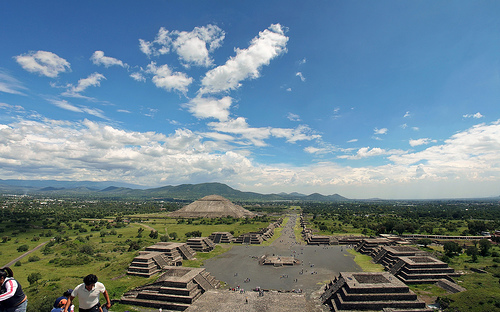
The great road (Road of the Dead) is 40 meters and its axis is slightly off to the northeast, 15º 30 'with respect to the geographical north. Along the street there are the most important buildings destined to temples, palaces and houses of characters of height. There are, besides the two great pyramids, the House of the Priest, the palace of Quetzalpapalotl (Quetzalmariposa), the palace of the Jaguars, the structure of the feathered shells, the temple of Quetzalcoatl, the citadel and many buildings more than in its day they were of great beauty. In one of the rooms floors were discovered built with two layers of mica sheets 6 cm thick, which were later covered with tezontle. The visitor can contemplate this curiosity whenever he asks the guard of the enclosure.
The big bases
They have a core made of adobe. Later they were
covered in stucco and stone and added a frieze adorned with
geometric reliefs were built as the base of a temple that was on the
platform. The Spaniards who arrived in the sixteenth century, still
managed to see the idols of the Sun and the Moon.
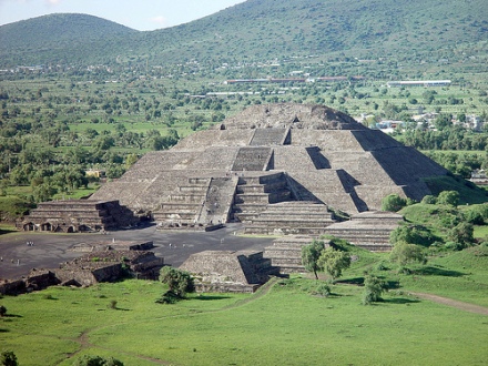
The Pyramid of the Moon is one of the oldest buildings in Teotihuacán. During the 19th century it was also known as Meztli Iztácual, a name that Manuel Orozco y Berra collects in his work, where he maintains the nineteenth-century hypothesis that Teotihuacán was a Toltec city.70 Its final form was acquired after seven constructive stages. It has an approximately square floor of 45 meters per side. It is smaller than the Pyramid of the Sun, but it is at the same height because it is built on higher ground. Its height is 45 m. Next to this pyramid was a statue called the Goddess of Agriculture that archaeologists locate in the early Toltec era. This pyramid is located very close to the Sun, closing the precinct of the city to the north. From its esplanade begins the route of the main axis known as Via o Calzada de los Muertos (Road of the Dead).
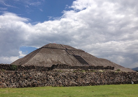
The Pyramid of the Sun is the largest building in Teotihuacán
and the second in all of Mesoamerica, just behind the Great
Pyramid of Cholula. Due to its considerable dimensions, it can
be seen several kilometers away. It has a height of 63 meters,
with an almost square plant of approximately 225 meters per
side, so it is often compared to the Pyramid of Cheops in Giza
(Egypt). The building consists of five superimposed
frustoconical bodies and an attached structure of three bodies
that do not reach the height of the first platform. The pyramid
of the sun is located on the eastern side of the Calzada de los
Muertos, practically aligned perpendicular to this road. The
current image of the pyramid corresponds to the restoration made
by Leopoldo Batres between 1905 and 1910, since as part of the
commemoration of the Centennial of the Independence of Mexico
several buildings of the city were enabled to turn them into a
tourist attraction. Batres has been criticized later for hasty
and incomplete, in addition to that was made on conceptions of
Mesoamerican architecture based on Egyptian models.
In
the beginnings of Teotihuacán, the site where the Pyramid of the
Sun is located corresponded to a kind of wall with slope base
and vertical deflection without association with other
structures. The use of this structure is unknown, although
Sugiyama suggests that it could serve to delimit a sacred space.
The pyramid of the Sun had two constructive stages, during the
first one it practically reached the dimensions that it
currently has. The use of the pyramid of the Sun and the meaning
it had for the inhabitants of Teotihuacán remains an unknown.
In 1971 Jorge Ruffier Acosta found a tunnel under the
pyramid, whose access is in front of the attached platform. The
first researchers of the tunnel - which is also called "sacred
cave" - assumed that it was a natural cavern that was used for
ritual purposes, which would explain the construction of the
monument on it. Sugiyama and his team have shown that the cave
was completely dug by humans. The structure of the tunnel
reminds the underground tombs of the West since the access is
carried out through a 6.5 meter shot. The cavity extends to the
east for approximately 97 meters, at the end of the tunnel-which
practically coincides with the center of the building-is a
four-lobed chamber that, according to Sugiyama's hypothesis,
could contain a real tomb.
The Citadel is an
architectural ensemble located on the west side of the road of
the dead, south of the course of the San Juan River. The set
forms a large quadrangular square of approximately 400 meters
per side and was built during the Miccaotli phase, between 150
and 250 d. C. The whole of La Ciudadela also includes the
pyramid of the Feathered Serpent, which is surrounded by
thirteen secondary temples built on a platform. Behind the
Temple of the Plumed Serpents are two housing complexes that
could have been reserved for the Teotihuacan elite. In the
center of the square is a shrine with four staircases that gave
access to the platform. The Citadel became the political,
cultural and economic center of the city of Teotihuacán, site
that had corresponded to the whole of the Pyramid of the Sun
until then. The causes of this displacement from the center of
the city are unknown, but it could have been due to political
factors.
The pyramid of the Feathered Serpent is located
at a certain distance from the two great pyramids, in the
Causeway of the Dead. It was an archaeological discovery of
1920. It was buried by a pyramid with smooth walls, without any
ornamentation. At first it was thought that the sculptures that
accompany the feathered serpent heads, were representations of
Tlaloc, however they are Cipactli, which means crocodile, this
character was very important as it was represented with the
first day with which the 260-day lunar calendar began. That is
why the temple of quetzalcoatl, may have been a temple built at
the time.
In November 2010, researchers from the National
Institute of Anthropology and History sent a robot car, called
Tlaloque I and designed by the National Polytechnic Institute,
to explore a narrow tunnel, 8 meters deep and approximately 100
linear meters deep, located just below the temple. When making
use of a georadar, it was concluded that this tunnel leads to 3
chambers where investigators assume the remains of some
important Teotihuacán characters are found. According to the
archaeologist Verónica Ortega: "The first thing that there was
to do adoration in Teotihuacán was this tunnel and later they
put a place already sacred, there the Pyramid of the Sun was
built [...] The coating is totally mud, [the Teotihuacanos] try
to give a smooth appearance to these walls, probably so that the
people who entered here did not realize that they were following
the tunnel ". Previously, this place had been found by the
Mexica culture and, more recently, in the 1970s, although in the
latter no major findings were made.
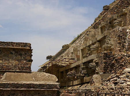
The palace of Quetzalpapálotl (in Nahuatl: quetzalli-papalotl, 'Butterfly-quetzal, butterfly of feathers, precious butterfly') is a building that was the dwelling of the Teotihuacan elite. More specifically, it has been proposed that it was the residence of the principal priests of Teotihuacán. The palace of Quetzalpapálotl is located in the southwest corner of the Plaza de la Luna, behind Structure 5 of this complex. To access its interior you have to climb a stairway guarded by jaguars. From the platform on which the building is located it is possible to descend to the central courtyard of the palace. This space is surrounded by porticos that frame the accesses to the inner chambers of the palace. The stone columns are carved profusely with representations of butterflies and quetzal feathers, hence the name of the palace. In the time that this building was in function, the reliefs in the columns were covered by bright colors. The interior walls were decorated with motifs related to the worship of the divinity of water. One of the substructures of this building is the patio of the Jaguars. The walls of this section are decorated with scenes depicting jaguars that carry plumes of quetzal feathers and, in front of them, representations of marine snails and human hearts.
Teotihuacán is a place name
of Nahuatl origin that was given to the city several centuries after
its decline by the Nahuatl peoples. The Aztecs used that name to
refer to the ruins of the ancient city, which had about 1,000 years
of neglect when they found it, and from them it was collected in
historical sources and in the use of the Spanish language during the
colonial era. The Aztec sources are the origin of many
misunderstandings about Teotihuacán, because they knew the city when
it had already been abandoned. For them, Teotihuacán was a city of a
past in which Tula also flourished, reason why they thought that its
inhabitants were Toltecs.
Several hypotheses have been
proposed about the meaning of the place name. We must remember that
Nahuatl is an agglutinative language that allows to express complex
ideas in a single word by adding affixes to a root. One of the most
well-known interpretations is that which translates Teotihuacán as
the place where the gods were born or equivalently Place where the
gods were made. This interpretation is related to the Legend of the
Suns, a well-known Mesoamerican-and particularly Nahua-cosmogonic
myth located in this city the creation of the Fifth Sun by the
sacrifice of all the gods of the previous era.
In the Dictionary of Nahuatl in the
Spanish language of Mexico, C. Montemayor says that it comes from
the words téotl (god), -ti (euphonical ligature), hua (possessive),
-can (locative that indicates the place where an action is performed
), so that translates it as a place for those who have gods.
The truth is that the name that the city received from its
inhabitants at the time of its flowering is unknown. Some texts
discovered in the Mayan area usually relate the puh (tule) glyph
with characters of Teotihuacan descent represented in stelae of
important Mayan cities such as Tikal, Uaxactún and Bonampak. Puh has
in the Mayan languages the same meaning as the Tollan word, which designated the fabulous city of Mesoamerican
mythology. Tollan was the archetype of the Mesoamerican civilization
and the origin of the legitimacy of the dominant lineages in
numerous states throughout the region. Mayistas have diverse
positions on the identity of Puh, some of them maintain that that
place mentioned in various Mayan texts is Teotihuacán. This
hypothesis could be reinforced by the discovery of several
representations of the puh glyph in the mural painting of the
Teotihuacan residential complex of Tepantitla.
Although this
legendary Tollan was originally identified with Tula,
the capital of the Toltecs, some researchers have preferred to
separate the myth from history, mainly because not only this city
but others of equal importance in Mesoamerica were called in the
same way. However, the distinction between historical cities and the
mythological city is not applied monolithically. Analyzing the
historical sources, the archaeological findings in the center of
Mexico and the Mayan area -like the referred case of the puh glyph
in the Lowlands-, Enrique Florescano makes an association of the
myth with the city of Teotihuacán, so that Tollan-Teotihuacan calls
it and attributes to the so-called city of the gods the identity of
the mythological Tula. This same position had been supported by
Laurette Séjourné in the congress of archaeologists where it was
established that the mythological Tollan was Tula,
and is shared by Stuart, Uriarte, and Duverger René Millon, one of
the most recognized specialists in the subject of Teotihuacán,
believes that indeed Teotihuacán is the legendary Tollan, but does
not accept that this has been his name.
Teotihuacán, in
addition to designating the historic city and the set of
archaeological monuments that are open to the public's visit, is
also the name of a Mexican municipality (San Juan Teotihuacán) and
its capital (Teotihuacán de Arista).
By car (or taxi)
It takes about 45 minutes from the Mexico City,
city center if you use the toll highway. It takes much longer, but
more interesting, if you use the old free road. There is a small fee
for parking at the site. A taxi may be prohibitively expensive,
though sometimes tours with a car and driver/guide can be arranged
for a reasonable fee if you want the convenience.
By bus
Buses to Teotihuacan leave from Mexico City about every half hour
from two locations: Terminal del Norte (outside Autobuses del Norte
Metro station, Line 5) or from outside the Potrero Metro station
(Line 3). A one-way ticket will cost 50 pesos (July 2017). From
Terminal Autobuses del Norte, walk towards Gate 8. There is a ticket
booth almost at the end of the concourse. Check that your bus goes
to the site entrance of Teotihuacán ruinas and not just to the town
of San Juan Teotihuacán nearby. From Potrero, exit the station and
look for white buses that go to Piramides – they mean the pyramids
of Teotihuacán. The trip will take around an hour, and the buses run
until about 18:00. When alighting the bus, check the last departure
with the driver. You will be dropped off and picked up at Puerta 1
(closest to the Temple of Quetzalcóatl).
By tour bus
Most
travel agencies offer half or full day tours to the site, often
combined with the Plaza de las Tres Culturas and the Basilica of
Guadalupe, both of which are outside the city center. It’s a
convenient way to combine the three, but note our comments above
about getting to the site early. The price is around 700 pesos for
an adult. As with guided tours everywhere in the world, these tours
will waste much of your time by promoting gift shops, but they are
still a convenient way to get here for Mexico City-based tourists.
Transport around Teotihuacan
There is an entrance fee of M$75
(July 2017) to enter the park for non-Mexican visitors. This is a
large site, a lot of walking is required as there are few other ways
to navigate the complex, unless you have a car, then you can freely
drive around the perimeter (if you are staying at the hotel in the
park or heading to one of the many restaurants). There are
tractor-drawn wagons with seats and shelter that run on a schedule
known only to them. If you go by bus, they will deliver you to one
spot, from which you will be required to walk to and from. If you
tire easily, pack light for this excursion (i.e., no backpacks,
heavy purses, etc.)
There are plenty of friendly park police
there, they may limit your driving around the site unless you are
staying at the hotel. Taxi drivers are not allowed to drive you
around the site, you must have a destination, like a restaurant,
inside of the park. If you are adventurous and lucky, you may be
able to rent a bicycle to ride around the perimeter on the cobble
stone road (a bit bouncy). If you are visiting the site and do not
have an opportunity to explore the perimeter where the shops,
restaurants and old buildings are, you are missing out. Just a
little creativity should help you find some transportation inside of
the complex. The locals are very friendly and a few pesos will go a
long way. Try to at least find a ride around the perimeter to view
the complex. It will be worth the effort.