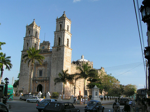
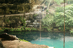
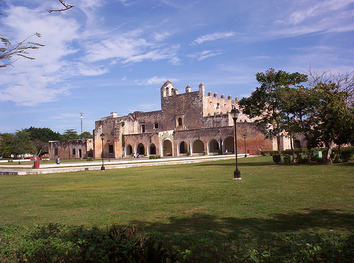
Valladolid is a pleasant city with distinct Spanish influence. The central plaza of Valladolid is dominated by a colonial cathedral of San Gervasio on one of its sides. Another notable places of interest include Convent of San Bernadino and Cenote Zaci which is a natural sinkhole with a restaurant by its side. It is quiet common to see citizens of the city to walk around in traditional clothes. Driving narrow streets, especially in the evening is fairly complicated by lack of rules. No one speeds, but drivers often stop to say greet friends. Narrow streets exclude possibility of driving around and you get stuck in a car. It is a fairly safe and friendly town, but just to be on a safe side stay on a busy streets and always be alert. Tourists are usually the easiest target for the criminal syndicate.
Cenote Zaci (Valladolid)
Named after Valladolid, at the time the capital of
Spain. The name derives from the Arabic expression Ballad Al-Walid
بلد الوليد, which means "city of Al-Walid", referring to Al-Walid I.
the first Valladolid in Yucatán was established by Spanish
Conquistador Francisco de Montejo's nephew on May 27, 1543 at some
distance from the current town, at a lagoon called Chouac-Ha in the
municipality of Tizimin. However, early Spanish settlers complained
about the mosquitos and humidity at the original location, and
petitioned to have the city moved further inland.
On March
24, 1545, Valladolid was relocated to its current location, built
atop a Maya town called Zaci or Zaci-Val, whose buildings were
dismantled to reuse the stones to build the Spanish colonial town.
The following year the Maya people revolted, but were put down with
additional Spanish troops coming from Mérida.
Valladolid had
a population of 15,000 in 1840. In January 1847, the native Mayans
rioted, killing some eighty whites and sacking their houses. After a
Mayan noble was shot by firing squad, the riot became a general
uprising. It was led by Jacinto Pat, batab of Tihosuco and by
Cecilio Chi of nearby Ichmul. The city and the surrounding region
was the scene of intense battle during Yucatán's Caste War, and the
Ladino forces were forced to abandon Valladolid on March 14, 1848,
with half being killed by ambush before they reached Mérida. The
city was sacked by the Maya rebels but was recaptured later in the
war.
Until the beginning of the 20th century, Valladolid was
the third largest and most important city of the Yucatán Peninsula,
(after Mérida and Campeche). It had a sizable well-to-do Criollo
population, with a number of old Spanish style mansions in the old
city. Valladolid was widely known by its nickname The Sultana of the
East.
By car
Valladolid is just off the toll highway
(180D) between Cancún and Merida; the exit is about 5 km (3 miles)
north of the center of town. The old highway (180) runs east-west
through the centre of town, and highway 295 connects south towards
Chetumal, and north to the toll highway and Ek Balam. Both highways
run right through the centre of town on one-way streets, forming the
four sides of the central town square.
By bus
Terminal de
Autobuses (main bus station), Calle 39 No 221, Col Centro (NE corner
of C/ 39 & 46, a couple blocks west of the central plaza (Parque
Francisco Canton) along C/ 39.), ☎ +52 985 856-3448. Frequent first
class services with ADO, ADO GL to Cancun (2hr to east); Merida (2hr
15m west) and Tulum (1hr30m to the southeast). Passengers transfer
in Merida or Cancun to get to additional cities. There are second
class services with Oriente and Mayab to other surrounding towns &
villages nearby such as to Piste, Chichen Itza, Izamal, etc and
further out to Merida, El Progreso and Cancun. The ride will take
longer with the frequent stops to get beyond the immediate area on
second class buses.
Terminal de Autotransportes de Oriente Viejo
(Old bus station), Calle 37 por 54 (Further west along Calle 37.).
The old bus station is now a second class bus station for buses
going to Merida, Cancun, El Progreso, El Piste, Chichen Itza,
Tiziman, Izamal, etc with Autocentro, Mayab and Oriente. The ride
will take longer with the frequent stops to travel longer distances.
The following are taxis and colectivos (shared ride taxis & vans) to
other towns and villages in the surrounding areas. They are
generally quicker in getting there than buses. With the agreements
they have with the local taxi unions they cannot provide local taxi
services. They are:
Sitio de Taxi UnTrac, Calle 37 entre 42 y 44
(Along Call 37 between 42 & 44). Taxis and colectivos going up to Ek
Balam and Hunuku (village).
Colectivos y Taxis a Piste y Chichen
Itza, Calle 39 No 215, entre 44 y 46 (Main entrance east of the main
bus station, past the Restaurante Squimz and Farmacia Similares). To
Piste & Chichen Itza.
Taxis Tizimin y Valladolid (Sitios Taxis
Foraneos), Calle 40, entre 35 y 37 (Inside and in front of the
"Estacionmento Centro" building along Calle 40 between 35 & 37. It's
on the left if going north on Calle 40.).
Collectivos a Ek
Balam, Calle 44 just north of Calle 37. To Ek Balam Ruins.
Transport around the city
Valladolid is small enough to make
walking a reasonable choice within town. To explore the city you can
also rent bicycles at a reasonable rate. Other alternative choices
are taxis (Be aware the drivers do not speak English). Locally the
streets or Calles are numbered with the odd numbered streets going
east and west and even numbered streets going north and south. The
street numbers get higher as you go from east to west and from north
to south. Directions and addresses can be given with the locations
such as Calle 41 No 201, entre 42 y 44 meaning Building #201 along
Calle 41 (going east & west) between 42 & 44 (going north & south).