Location: 8 km (5 mi) West of Oaxaca, Oaxaca Map
Tel. (951) 516 1215
Open: 8am- 6pm daily
Entrance Fee: 30 pesos, Free on Sundays and holidays
Monte Alban is an ancient Zapotec tribe archaeological site situated 8 km (5 mi) West of Oaxaca, Oaxaca in Mexico. It was one of the first cities in Mesoamerica and at its peak it covered an area of 20 square kilometres. The ancient name for Monte Alban Archaeological Site was Dani Biaa or "sacred mountain" or "sacred hill". Modern name of Montalbán was given the Spanish conquistadors after similarity in landscape with Alban Hills in Italy. Only small central portion of the settlement is uncovered. Archeologists still work on surrounding area that was inhabited mostly by regular people. Monte Alban was added to the UNESCO World Heritage Site for its significant architectural and historic value for the whole World.
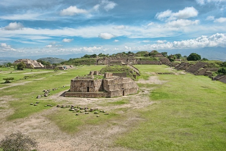
This site was chosen as a strategic location on a plateau (elevation: 1,900 meters/ 3,280 feet) overlooking the junction of Atoyac and Salado river valleys. Rising at a height of 300 meters above valley floor it was settled by the Zapotecs in 800 BC. Refugees came from former capital of San Jose Mogote in Etla valley. Around 500 BC the city grew large enough to undertake massive construction. A top of the mountain in the center of the city was cut to make way for a I- shaped plaza to make room for palaces, ball court, temples and other important civil and religious structures.
Zapotec capital reached a peak of its political and economic might during Classic Period (300- 750 AD) with over 25,000 inhabitants. It established trade routes with Teotihuacan (north of Mexico City) and Tikal in Guatemala. Priests followed a 365 days calendar to mark different time period of city life. Monte Alban was abandoned around 750 AD in favor of another capital of Zaachila in the Zimatlan valley. New tribe of Mixtec people settle briefly on the ruins of the abandoned city in 1300- 1400 AD. They left many ceremonial offerings in the Tomb #7.
North Platform is a large platform with several temples at the top. A beautiful view of the valley bellow opens here. You have to climb an impressive staircase to get to the top.
South Platform is situated on the South end of the I- shaped great plaza. Much of its territory is covered by a single large platform with a small pyramid at the top known simply as a Mound III. This part of the city is also accessible by a large staircase.
Ballcourt or Juego de Pelota was an important religious site where Zapotecs played their games. The players could only use their shoulder, elbows, knees and hips to hit the ball. The players of the losing team were sacrificed to the pagan gods. In the ancient times it was covered by red stucco, but today most of it is gone. It is situated in the Eastern side of the Central Plaza.
This was probably a residential buildings of an important priest or a ruler of the city or possibly both. Archeologists discovered a tunnel (pictured left) that led from the palace to the pyramid H in the center of the Grand Plaza. It was probably used during religious ceremonies and a head of this ceremony would use this tunnel to suddenly appear in the center of the platform to awe of all residents who were present.
This tomb was constructed in the last decades of the existence of Monte Alban. It was constructed to keep the body of ruler of Mixtec people. It was uncovered by Mexican archaeologists in the early 1930s.
Building J situated in the center of the plaza served probably as a astronomical observatory for ancient religious leaders.
Los Danzantes is a group of religious buildings in the South- western part of the central plaza. The name is translated as "dancers". It was given by archeologists due to Olmec carvings that were represented in various poses. In reality these were probably mutilated and killed prisoners who were captured in numerous battles that the Zapotecs carried out. These slabs are only copies. The actual reliefs are kept in the archeological and historic museum of the site.
On the map to the right you trace the movement of the Zapotec people from their previous home of San Jose Mogote in Etla valley to Monte Alban in the center of the three valleys and further south to their later capital of Zaachila in the Zimatlan valley.
Being visible from anywhere in the central part of
the Valley of Oaxaca, the impressive ruins of Monte Albán attracted
visitors and explorers throughout the colonial and modern eras.
Among others, Guillermo Dupaix investigated the site in the early
19th century CE, J. M. García published a description of the site in
1859, and A. F. Bandelier visited and published further descriptions
in the 1890s. A first intensive archaeological exploration of the
site was conducted in 1902 by Leopoldo Batres, then General
Inspector of Monuments for the Mexican government under Porfirio
Diaz. It was however only in 1931 that large-scale scientific
excavations were undertaken under the direction of Mexican
archaeologist Alfonso Caso. In 1933, Eulalia Guzmán assisted with
the excavation of Tomb 7. Over the following eighteen years Caso and
his colleagues Ignacio Bernal and Jorge Acosta excavated large
sections within the monumental core of the site, and much of what is
visible today in areas open to the public was reconstructed at that
time. Besides resulting in the excavation of a large number of
residential and civic-ceremonial structures and hundreds of tombs
and burials, one lasting achievement of the project by Caso and his
colleagues was the establishment of a ceramic chronology (phases
Monte Albán I through V) for the period between the site's founding
in ca. 500 BCE to end of the Postclassic period in CE 1521.
The investigation of the periods preceding Monte Albán's founding
was a major focus of the Prehistory and Human Ecology Project
started by Kent Flannery of the University of Michigan in the late
1960s. Over the following two decades this project documented the
development of socio-political complexity in the valley from the
earliest Archaic period (ca. 8000-2000 BCE) to the Rosario phase
(700-500 BCE) immediately preceding Monte Albán, thus setting the
stage for an understanding of the latter's founding and
developmental trajectory. In this context, among the major
accomplishments of Flannery's work in Oaxaca are his extensive
excavations at the important formative center of San José Mogote in
the Etla branch of the valley, a project co-directed with Joyce
Marcus of the University of Michigan.
A further important
step in the understanding of the history of occupation of the Monte
Albán site was reached with the Prehistoric Settlement Patterns in
the Valley of Oaxaca Project begun by Richard Blanton and several
colleagues in the early 1970s. It is only with their intensive
survey and mapping of the entire site that the real extension and
size of Monte Albán beyond the limited area explored by Caso became
known. Subsequent seasons of the same project under the direction of
Blanton, Gary Feinman, Steve Kowalewski, Linda Nicholas, and others
extended the survey coverage to practically the entire valley,
producing an invaluable amount of data on the region's changing
settlement patterns from the earliest times to the arrival of the
Spanish in CE 1521.