Location: Piscataquis County Map
Area: 209,501 acres (847.8 km²)
Camping:
Reserve sites at least 5 months before a trip.
Tel. (207) 723 5140
Fee: $6 per person per night
|
Trail |
Route |
Miles |
|
Appalachian Trail |
Park line to Katahdin Stream |
4.95 |
|
Abol Trail |
Abol to Thoreau Spring |
2.76 |
|
Hunt Trail |
Katahdin Stream to Baxter Peak |
5.19 |
|
The Owl Trail |
Katahdin Stream to the Owl |
3.00 |
|
O.J.I. Trail |
Perimeter road to O.J.I |
2.71 |
|
Sentinel Mt. Trail |
Kidney Pond to Sentinel Mt. |
2.60 |
|
Doubletop Mt. Trail |
Nesowadnehunk to Kidney Pond |
7.80 |
|
Marston Trail |
Slide Dam to North Brother |
4.24 |
|
Webster Lake Trail |
Black Brook to Webster Lake |
7.20 |
|
Freezeout Trail |
Webster Lake to Second Lake Matagamon |
9.0 |
|
Freezeout Trail |
Second Lake Matagamon to Trout Brook Farm |
6.10 |
|
Trout Brook Mt. Trail |
Trout Brook Farm to Trout Brook Mt. |
1.30 |
|
Horse Mt. Trail |
Perimeter road to Horse Mt. Tower |
1.35 |
|
Fowler Pond Trail |
Perimeter road to Fowler Pond |
2.00 |
|
Middle Fowler Trail |
So. Branch Pond to Middle Fowler Pond |
4.10 |
|
So. Branch Falls Trail |
So. Branch Pond road to the falls |
0.43 |
|
So. Branch Mt. Trail |
So. Branch Pond to Pogy Notch Trail via Black Cat. Mt. |
4 06 |
|
North Traveler Trail |
So. Branch Pond to North Traveler |
2.55 |
|
Center Ridge Trail |
Pogy Notch Trail to the Traveler |
1.75 |
|
Pogy Notch Trail |
So. Branch Pond to the Traveler |
9.61 |
|
Lookout Trail |
Russell Pond Campground to The Lookout Ledge |
1.25 |
|
Grand Falls Trail |
Russell Pond to Grand Falls via Inscription Rock |
2.75 |
|
Wassataquoik Lake Trail |
Russell Pond to Wassataquoik Lake |
2.70 |
|
Wassataquoik Lake Trail |
Wassataquoik Lake to Nesowadnehunk Field |
8.30 |
|
Russell Pond Trail |
Russell Pond to Roaring Brook |
7.00 |
|
Howe(north) Peaks Trail |
Russell Pond to Hamlin Peak |
6.85 |
|
Northwest Basin Trail |
Russell Pond to The Saddle |
7.96 |
|
So. Turner Mt. Trail |
Roaring Brook to S. Turner Mt. via Sandy Stream Pond |
2.00 |
|
Whidden Pond Trail |
Sandy Stream Pond to Whidden Pond |
0.90 |
|
Helon Taylor Trail |
Roaring Brook to Pamola |
3.16 |
|
Knife Edge Trail |
Pamola to Baxter Peak |
1.10 |
|
Chimney Pond Trail |
Roaring Brook to Chimney Pond |
3.30 |
|
Dudley Trail |
Chimney Pond to Pamola |
1.25 |
|
Cathedral Trail |
Chimney Pond to Baxter Peak |
1.70 |
|
Saddle Trail |
Chimney Pond to Baxter Peak |
2.17 |
|
Hamlin Ridge Trail |
Chimney Pond to Hamlin Peak |
1.95 |
|
North Basin Trail |
Chimney Pond Trail to No. Basin Ponds |
1.25 |
Appalachian Trail to Mt. Katahdin
Distance: 46 mi (74 km)
Duration: 6 days
Difficulty: medium- hard
Start/ End point: Lake Nahmakanta- Katahdin Stream Campground
There is no electricity, running water, or paved roads in the park.
The use of radios, stereos and cell phones is also prohibited, in
keeping with the “forever original” philosophy. Winter hikes are
strictly regulated but increasingly popular. The park is open for
camping (overnight stays) from May 15th to October 15th. Only
northbound Appalachian Trail hikers can stay in the park without a
reservation; stay will be limited to one night at The Birches
campsite, limited to the first twelve hikers. You have to register
in advance at the information kiosk. It is many kilometers further
south. In addition to hiking and camping, the park allows limited
hunting and fishing, snowmobile access. He also maintains a small
scientific forest project.
Police and fire protection in the
park are provided by the State of Maine; Garbage removal and
recycling is largely done by those who visited the park. Maintaining
it is done by many volunteer workers and paid employees of the park.
The current park director is Jensen Bissell.
The park was a gift to the people of Maine from Governor Percival Baxter, who used his personal wealth to purchase and donate the park's original 2,000 acres (813 km²). Since his death in 1969, the park's area has increased to its current size, with the addition (2006) of a 19 km² parcel and the spectacular Katahdin Lake. The headquarters are located over 20 miles from the current park in the small town of Millinocket. There are no shops or gas stations in the park. Access and use are strictly regulated, in keeping with Governor Baxter's desire to keep the park "forever pristine."
Baxter Park has an area of 847 km2 located in the unorganized territory of Northeast Piscataquis, itself located in Piscataquis County, with the exception of a small section to the northeast located in the unorganized territory of North Penobscot, in Penobscot County.
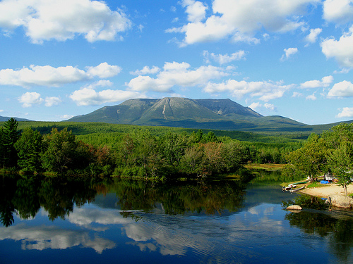
The relief of the park is dominated by a massif to the south and a mountain range to the north. In the center-south we find the massif of Mount Katahdin whose summit, Baxter Peak, is at 1,606 m, making it the highest point in the State of Maine. Further to the north-east we find the small Traveler Range whose summit, The Traveler, rises to 1,079 m. The rest of the park is a plain whose altitude varies between 180 m and 300 m.
Wildlife
The ungulates that frequent the park are the moose
(Alces alces) and the white-tailed deer (Odocoileus virginianus).
The carnivores found in Baxter are the black bear (Ursus
americanus), the river otter (Lontra canadensis), the American mink
(Neovison vison), the American marten (Martes americana), the fisher
(Martes pennanti), the weasel (Mustela sp.), the Coyote (Canis
latrans), the Bobcat (Lynx rufus) and the Raccoon (Procyon lotor).
Among the small mammals we find the Canadian Beaver (Castor
canadensis), the Muskrat (Ondatra zibethicus), the Common Marmot
(Marmota monax), the Snowshoe Hare (Lepus americanus), the Gray
Squirrel (Sciurus carolinensis), the red squirrel (Tamiasciurus
hudsonicus), the eastern chipmunk (Tamias striatus), the flying
squirrel (Glaucomys sp.), the mouse, the vole and the lemming vole
(Synaptomys sp.).