Location: Garfield and Kane Counties, Utah Map
Area: 35,835 acres
Closed: Jan 1, Thanksgiving, Dec 25
Visitor
Center: mid- Apr- Jun: 8am- 6pm
Jun- Oct: 8am- 8pm
Oct- Apr: 8am-
4:30pm
Official site
Information Center
Open: 8am-8pm May- Sept
8am- 6pm Oct-
Apr
8am- 4:30pm Nov- March
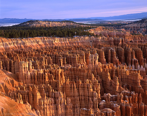
Bryce Canyon National Park is situated in Garfield and Kane Counties in Utah, United States. This majestic nature reserve of Bryce Canyon covers an area of 35,835 acres. Bryce Canyon National Park is located in the North- East of Utah state. It is one of the largest and most beautiful natural reserves in the United States. In reality it is not really a canyon, but a huge natural amphitheater carved by years of erosion by wind and water. It left numerous sharp rocky peaks of various shades ranging from pink to orange. Unlike other natural parks in the area Bryce Canyon can be viewed in its entirety from viewing platforms located at the top of the canyon. Many tourists visit Bryce Canyon National Park along with visiting Grand Canyon National Park and Zion National Park found in the area.
Bryce Canyon National Park was after one of its earliest European settler, Mormon Ebenezer Bryze who settled here in 1875 on the top edge of the Bryce Canyon. In 1924 Bryce Canyon was designated as a Natural Park. It covers a total area of 56 square miles (145 sq km). The height of the edges ranges from 2,400 to 2,700 meters. The best time to visit Bryce Canyon and make great pictures is at dawn or at sunset when sun rays create an otherworldly appearance of this unique geologic formation. Additionally there are numerous astronomical programs for kids and adults alike. Authorities of Bryce Canyon National Park also hold night hikes during the full moon.
The closes international airport in the close proximity to Bryce Canyon National Park is in Las Vegas and Salt Lake City (430 km away). Additionally Delta airlines make flights from Salt Lake City to Cedar City, which is only 130 km away. Another option might be United Airlines or Delta that can take you to Saint George (200 km) from Salt Lake City or Los Angeles.
American South West is famous for its changing weather and sudden drops of temperature as well as sudden and devastating flash floods. The warmest months in Bryce Canyon National Park is June and July. Air temperature reaches +30C. In winter months between December and February the temperature might drop to -15 C. Bryce Canyon National Park is open all year every day. However, during winter months some of the roads might be closed due to excessive snowfalls.
Private, non-commercial vehicles must pay a $30
entrance fee that is good for 7 days. For individuals (applies to
motorcycles, bicyclists, or individuals traveling on foot) the fee
is $12 for 7 days. The entrance fee includes free and unlimited use
of the park shuttles during the summer.
There are several
passes for groups traveling together in a private vehicle or
individuals on foot or on bike. These passes provide free entry at
national parks and national wildlife refuges, and also cover
standard amenity fees at national forests and grasslands, and at
lands managed by the Bureau of Land Management and Bureau of
Reclamation. These passes are valid at all national parks including
Bryce Canyon National Park:
The $80 Annual Pass (valid for
twelve months from date of issue) can be purchased by anyone.
Military personnel can obtain a free annual pass in person at a
federal recreation site by showing a Common Access Card (CAC) or
Military ID.
U.S. citizens or permanent residents age 62 or over
can obtain a Senior Pass (valid for the life of the holder) in
person at a federal recreation site for $80, or through the mail for
$90; applicants must provide documentation of citizenship and age.
This pass also provides a fifty percent discount on some park
amenities. Seniors can also obtain a $20 annual pass.
U.S.
citizens or permanent residents with permanent disabilities can
obtain an Access Pass (valid for the life of the holder) in person
at a federal recreation site at no charge, or through the mail for
$10; applicants must provide documentation of citizenship and
permanent disability. This pass also provides a fifty percent
discount on some park amenities.
Individuals who have volunteered
250 or more hours with federal agencies that participate in the
Interagency Pass Program can receive a free Volunteer Pass.
4th
graders can receive an Annual 4th Grade Pass that allows free entry
for the duration of the 4th grade school year (September-August) to
the bearer and any accompanying passengers in a private
non-commercial vehicle. Registration at the Every Kid in a Park
website is required.
In 2018 the National Park Service will offer
four days on which entry is free for all national parks: January 15
(Martin Luther King Jr. Day), April 21 (1st Day of NPS Week),
September 22 (National Public Lands Day), and November 11 (Veterans
Day weekend).
Bryce Canyon National Park is located in southwest Utah about 80 km
from Zion National Park. Being 300 meters higher means lower
temperatures and more precipitation.
The national park is located
on the Colorado Plateau, more precisely on the southeastern edge of the
Paunsaugunt Plateau. The name Paunsaugunt derives from the Uto-Aztec
language of the Paiute Indians and means home of the beaver. Visitors
reach the park from the plateau side and look over the edge into the
Pariatal with the river of the same name. The word pariah also comes
from the Uto-Aztec and means elk or wapiti water.
Bryce Canyon
was not formed by a river. It is therefore not a canyon in the true
sense of the word, such as the Grand Canyon. Wind, water and ice eroded
the edge of the plateau into large amphitheaters with bizarre rock
needles, so-called hoodoos. These rock needles reach a height of up to
60 meters. The resulting amphitheaters extend over a length of over 30
km. The largest amphitheater is called Bryce Canyon. It is nearly 5 km
wide, 19 km long and drops over 240 meters from the plateau.
Early Indian settlements
Little is known about the early human
occupation of this park. Archaeological finds date back 10,000 years. A
few finds from the southern part of the area are attributed to the early
Anasazi Indians of the basket-making era, and a few more recent finds to
the Anasazi of the Pueblo era.
When the Anasazi Indians left the
area for reasons still unknown, the Paiute Indians came, but there are
hardly any traces of settlement. The Paiute used this area more as a
hunting ground. But remains of cultivated plants and agricultural use
have also been found. The Paiute call the hoodoos anka-ku-wass-a-wits,
red-painted faces.
Exploration and settlement by whites
Exploration of this area began as early as the 19th century. Around 1850
the first Mormons came to investigate the area for farming and animal
husbandry.
The first scientific expedition reached the area in
1872, led by the U.S. Major John Wesley Powell. The cartographers of
this expedition took many names from the Paiute.
A year later, a
small group of Mormons came and settled to raise cattle along the Pariah
River.
In 1875, Ebenezer Bryce was sent here by The Church of
Jesus Christ of Latter-day Saints to help develop the area as a
carpenter. He built a road up to the plateau to cut down trees for
boards and firewood. He saw the natural wonder more from the practical
side and described it as "a hell of a place to lose a cow". His
neighbors called the canyon near his cabin Bryce's Canyon. Along with
other settlers, Ebenezer Bryce built a canal to deal with the constant
flooding followed by droughts. But the project failed, and in 1880 he
moved on to Arizona.
The emergence of the park
Powell's
reports and other newspaper reports encouraged interest in the area, but
the lack of infrastructure meant that tourism was limited.
Around
1920, the first overnight accommodations were created and the Union
Pacific Railroad also opened up the area, so that more and more tourists
came to Bryce Canyon. However, unbridled tourism quickly inflicted
damage on the hoodoos and other geological formations. The then governor
of Utah supported efforts to protect the canyon, and President Warren G.
Harding declared the canyon a national monument in 1923.
In 1924,
the Utah Congress attempted to establish Utah National Park, which
succeeded in 1928. However, the name stuck with Bryce Canyon National
Park.
In 1931, under President Herbert Hoover, additional land
south of the park was incorporated into the park, increasing its area to
over 14,000 acres. In 1934 construction began on the Scenic Drive, which
still runs through the park today. Management of the park remained with
the Zion National Park Administration until 1956. Since then the park
has had its own administration.
Due to increased tourism, a
shuttle system was established in 2000. There are efforts to make large
parts of the park only accessible via this shuttle system, as is already
the case in Zion National Park.
The rocks in Bryce Canyon National Park are about 100 million years
younger than those in Zion National Park, and this one features rocks
that are another 100 million years younger than those in the Grand
Canyon. Nevertheless, all three areas belong to a formation called The
Grand Staircase. From the Grand Canyon to Bryce Canyon you can study
nearly 200 million years of geological history.
The rocks in the
national park are a succession of basalt and sandstone in which many
fossils can be found. These exposed layers are the youngest in this
formation. Sandy beaches, lagoons and a swamp landscape can still be
seen today.
As the area rose due to mountain building, numerous
lakes formed, the sediments of which covered the basalt and sandstone.
This lake district lasted about 20 million years and ended about 60
million years ago. During this time, the lakes changed, among other
things due to climatic changes. Due to strong variation in size and
depth, they left behind strongly changing sediment layers.
About
16 million years ago, the plateau rose by almost 1000 meters. Before
that time, the area was almost at sea level. The entire plateau is
called the Colorado Plateau. It broke up into numerous smaller plateaus.
One of them is the Paunsaugunt plateau.
As the American continent
drifted further north, the climate on the plateau changed, becoming
significantly cooler and precipitation also increasing. Frequent
rainfall and erosion by freezing water shaped the modern face of the
numerous amphitheaters that form an east-facing escarpment. There are
still up to 200 freezes and thaws each year that continue to erode the
park.
Predators range from foxes and other smaller animals to the
occasional migrant bobcat (Lynx rufus), mountain lion (Puma concolor)
and black bear (Ursus americanus). The largest permanent mammal in the
park is the mule deer (Odocoileus hermionus). Elk (Cervus elaphus) and
pronghorn (Antilocapra americana), reintroduced into neighboring areas,
are also occasional "visitors". A very common sight are the
golden-mantled ground squirrel (Spermophilus lateralis) and rock
squirrel (Spermophilus variegatus), as well as the Uinta chipmunk
(Eutamius umbrinus) and Utah prairie dogs (Cynomys parvidens). Mule
deer, cougars, and coyotes migrate to lower-lying areas in winter, while
ground squirrels and marmots hibernate.
Most of Bryce Canyon
National Park's bird species migrate south during the winter (migratory
birds), such as the Violet Swallow (Tachycineta thalassina) and the
Common Swift. However, some remain year-round, including jays (notably
the pine jay (Clark's nutcracker, Nucifraga columbiana)) and blue jay
(Steller's jay, Cyanocitta stelleri) and common ravens (Corvus corax),
ospreys (Pandion haliaetus) and peregrine falcons (Falco peregrinus) as
well as various owls and nuthatches.
The herpetofauna consists of
eleven reptile and four amphibian species. Particularly conspicuous
among the snakes are the Great Basin prairie rattlesnake (Crotalus
viridis lutosus) and the striped whip snake (Masticophis taeniatus),
among the iguanas the short-horned horned horned lizard (Phrynosoma
douglassi) and the common side-spotted iguana (Uta stansburiana). Among
the amphibians, the tiger salamander (Ambystoma tigrinum) is one of the
most interesting species.
Due to the different heights and the
associated differences in vegetation within the park, different habitats
are delimited:
The lower areas of the park are characterized
primarily by pine and conifer forests interspersed with manzanita
(Arctostaphylos patula), Juneberry and antelope bitter bushes. Aspens,
water birches and willows can be found along the rivers.
Stands of
ponderosa pine (Pinus ponderosa) characterize the middle layers,
supplemented in wetter areas by blue spruce and Douglas fir and Rocky
Mountain juniper.
On the Paunsaugunt plateau, Douglas fir
predominates, along with aspen and Engelmann spruce. The Nevada circular
pine (Pinus flexilis) and bristlecone pine (Pinus longaeva) dominate the
coldest and highest areas of the national park.
A very dark and
nutrient-rich soil characterizes the park. Together with the abundance
of water in the region, it ensures optimal living conditions.
The 29-kilometer scenic drive leads to a total of 13 viewpoints,
including Sunrise Point, Sunset Point, Inspiration Point and of course
Bryce Point. Further south of the park are Natural Bridge (geologically
not a bridge but an arch), Rainbow Point and Yovimpa Point.
The
park offers numerous hiking trails of different lengths and levels of
difficulty, such as:
Rim Trail between Sunset and Sunrise Points
(easy, less than 2 km)
Mossy Cave (easy, less than 2km)
Upper
Inspiration Point (moderate, less than 2 km)
Swamp Canyon Loop
(moderate, 7 km)
Navajo Loop (moderate, 3 km)
Riggs Spring Loop
(difficult, 14 km)
Queen's Garden Trail
Peek-a-boo Loop
(difficult; can be combined with Queen's Garden Loop and a path from the
Navajo Loop as entry point, then approx. 12 km, 550 m elevation gain)
The air in Bryce Canyon National Park is so clear and the area so
dark at night due to a lack of infrastructure that you can see well over
7500 stars in the sky with the naked eye. Up to 2000 visible stars are
common in inhabited, light-polluted areas. Due to the clear air, distant
views of up to 320 km to Arizona and even New Mexico are possible on
nice days.