Location: Riverside and San Bernardino counties, CA Map
Area: 789,745 acres (1,234 sq mi, 3,196 km2)
Official site
Joshua Tree National Park is situated in Riverside and San Bernardino counties in California, United States. Joshua Tree National Park covers a total area of 789,745 acres. Joshua Tree National Park is a protected area located in the South- Eastern California on the border of Mojave and Colorado Desert (part of Sonoran deserts). Mojave Desert is higher and cooler area of the Joshua Tree National Park. The name of the protected reserve comes from a forest of Joshua Trees (Yucca brevifolia) as well as unique rock formation (known as Inselbergs) that dominate the area.
The Irish band U2 took photos of the whole group
in this park for their album of the same title, The Joshua Tree,
winner of a Grammy award and recognized as the best work of the
group. Other photos of this album were taken in the ghost town of
Bodie, California (Sierra Nevada
Mountains in California), and mainly in the
Death Valley National
Park. Precisely in the surroundings of this is where the photo
of the iconic and iconic Joshua tree that appears on the back cover
was taken. A part of Joshua Tree National Park is covered by rounded
rocks of low height, which are one of the attractions of the park,
especially for practitioners of the climbing mode called bulder. The
San Andrés fault delimits an area to the south of the park, this
being an area of seismic activity.
The rich fauna and flora
of this area made it attractive for the establishment of
hunter-gatherer peoples in the past. In the 19th century, the
California Gold Rush motivated the establishment of mining towns and
farmers. At present, Joshua Tree National Park is not inhabited or
commercially exploited, being a protected area since 1936.
Fees for entry, as of 26 July 2018, are:
$30
for a 7-day single vehicle pass
$25 for a 7-day motorcycle pass
$15 for a 7-day pass for an individual on foot or on a bicycle
$55 for the Joshua Tree National Park Annual Pass (good for 12
months, covers the entrance fee for the pass signee and accompanying
passengers entering in a single, non-commercial vehicle)
There are several passes for groups traveling
together in a private vehicle or individuals on foot or on bike.
These passes provide free entry at national parks and national
wildlife refuges, and also cover standard amenity fees at national
forests and grasslands, and at lands managed by the Bureau of Land
Management and Bureau of Reclamation. These passes are valid at all
national parks including Joshua Tree National Park:
The $80
Annual Pass (valid for twelve months from date of issue) can be
purchased by anyone. Military personnel can obtain a free annual
pass in person at a federal recreation site by showing a Common
Access Card (CAC) or Military ID.
U.S. citizens or permanent
residents age 62 or over can obtain a Senior Pass (valid for the
life of the holder) in person at a federal recreation site for $80,
or through the mail for $90; applicants must provide documentation
of citizenship and age. This pass also provides a fifty percent
discount on some park amenities. Seniors can also obtain a $20
annual pass.
U.S. citizens or permanent residents with permanent
disabilities can obtain an Access Pass (valid for the life of the
holder) in person at a federal recreation site at no charge, or
through the mail for $10; applicants must provide documentation of
citizenship and permanent disability. This pass also provides a
fifty percent discount on some park amenities.
Individuals who
have volunteered 250 or more hours with federal agencies that
participate in the Interagency Pass Program can receive a free
Volunteer Pass.
4th graders can receive an Annual 4th Grade Pass
that allows free entry for the duration of the 4th grade school year
(September-August) to the bearer and any accompanying passengers in
a private non-commercial vehicle. Registration at the Every Kid in a
Park website is required.
In 2018 the National Park Service will
offer four days on which entry is free for all national parks:
January 15 (Martin Luther King Jr. Day), April 21 (1st Day of NPS
Week), September 22 (National Public Lands Day), and November 11
(Veterans Day weekend).
Joshua Tree National Park is located in southern California, about
140 miles east of Los Angeles near Palm Springs. The national park has
three entrances, the main entrance near the town of Twentynine Palms,
the west entrance in Joshua Tree Village, and the south entrance in
Cottonwood Springs. The park is 3196 km² in size, it lies between 305 m
above sea level in the Pinto Basin and 1772 meters on the peaks of Quail
Mountain. The park includes two desert types, which - due to their
different altitudes - have two different types of ecosystems. Below
1,000 feet in the eastern portion of the park is the Colorado Desert, a
landscape of scrubland, cacti and fan palms. The Mojave Desert in the
northwest is higher and therefore cooler and wetter. Here is the home of
the Joshua Trees, which gave the park its name.
The climate in
Joshua Tree National Park is very dry overall, but varies depending on
the altitude. The average humidity is around 25%. The temperatures in
spring and autumn are around 20 °C during the day and around 10 °C at
night. In summer, 35 °C and more are not uncommon. During the winter
months, temperatures drop slightly below freezing at night, but can
reach plus 15°C during the day.
The monzogranite formations in the park were formed when magma cooled
and solidified beneath the surface of the earth, and was exposed at the
surface after millions of years of erosion. The most spectacular rock
formations are at Jumbo Rocks, Wonderland of Rocks and Indian Cove.
At the beginning of European settlement, the area of the park was
inhabited by the Cahuilla. It is said that Mormons who crossed the
Mojave Desert gave the Joshua Tree its name. They recognized the figure
of the prophet Joshua (Joshua) in the plants, who showed the Israelites
the way to the promised land with outstretched arms. However, there do
not seem to be any historical sources for this frequently repeated myth.
On August 10, 1936, the park was declared a national monument, and on
October 24, 1994, it was upgraded to a national park by the United
States Congress.
During the US government shutdown from December
2018 to January 2019, the park suffered enormous damage because the park
rangers were not allowed to come to work. Vandals have cut down juniper,
acacia and even Joshua trees, vehicles have driven off-road through the
park leaving tracks that will damage the delicate soil in the long term,
sprayed rocks and lit bonfires in restricted areas. The damage could
last for 200 to 300 years.
In total, there are about 750 species of plants in the park. Animal
life is concentrated at five natural water points. The largest animal is
the desert bighorn sheep (Ovis canadensis nelsoni), and numerous bird
species can also be observed. As in most desert areas, the wildlife here
is predominantly nocturnal.
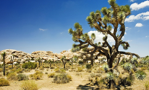
The most conspicuous plants are
Joshua trees, which are found exclusively in the Mojave Desert in the
northwestern part of the park. The Joshua palm is an important part of
the regional ecosystem, providing food and shelter to many desert
animals. The plants grow to over 12 meters in height and some
researchers estimate an average age of around 150 years, although some
of the largest specimens may be much older.[4] Its flowering time is in
April and May. In the Mojave Desert there are many of these trees, at
lower altitudes the vegetation is more dominated by the creosote bush.
The tourist infrastructure of the park is poorly developed. The only
places to stay are some simple campsites, most of which do not have
running water. There are hotels in the surrounding towns. There are few
roads and hiking trails.
The few roads in the park are passable
by car. The "Basin Road" leads from the south into the center of the
park. Access to the park from the north is via the North and West
Entrances on Park Boulevard. One of the places to visit is in the Lost
Horse Valley. It is located in the center of the park and shows the
flora and fauna in an impressive way.
A dirt road to the south of
the park gives an overview of its geology. The lookout at Keys View
offers views of the Coachella Valley and the Salton Sea. There are also
guided tours to an abandoned gold mine. Many spend New Year's Eve here.
In midsummer the park is very empty and sweltering hot from 9am.
Among other things, a road that is only accessible to four-wheel drive
vehicles leads through the park. It is accessible from the south off
Interstate 10 and leads onto Park Boulevard in the center of the park.
There are three visitor centers. There are exhibits about the park's
ecosystem, its wildlife, geological formations, and the first people to
inhabit the area. Park recreational activities include hiking, camping,
biking, rock climbing, ranch tours and ranger briefings.
The park
is very popular with rock climbers (often referred to as "J-Tree" by
them). Originally, the park was more of a winter retreat while Yosemite
National Park and the Sierra Nevada were snowed in, but over time the
park developed its own appeal. There are thousands of climbing routes of
all levels of difficulty. The routes are quite short as the rocks are
seldom higher than 70 meters, the access is usually quite easy. The rock
is rough granite as there is never ice or snow to polish it as is the
case in more northerly areas. Most routes have to be secured by
yourself.