Location: Utah Map
Surface Area: 658 km2 (254 sq mi)
Info: Carl Hayden Visitor Center, (928) 608 6404
Open: Apr- Oct: 8am- 5pm daily
Nov- Mar: 8am- 4:30pm daily
Lake Powell is situated in Utah, United States. It covers a total area of 658 km2 (254 sq mi). Lake Powell formerly known as Glen Canyon lake Powell was flooded in 1960’s. Lake Powell is the largest man- made lake in USA created in 1956 when parts of Glen Canyon was flooded after construction of a dam on the Colorado River. The resulting reservoir was named after the explorer John Wesley Powell, who in 1869 first explored the Colorado river and first explored the beauty of the surrounding landscapes.
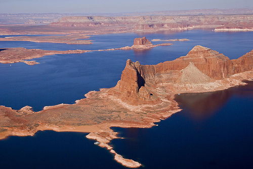
Lake Powell is surrounded by canyon walls of bright orange, red and
white sandstone. A rich palette of shades of rock formations perfectly
combine with the blue- green waters of the Powell reservoir. Since 1972
lake Powell and surrounding lands became the part of the recreation
area. The best way to travel around the lake Powell is to rent a boat as
water as a kind of highway to get around. Regulations are loose in the
area so any place can be considered as a campsite. Overland trails also
exist, but they are limited by geological formations.
Fishing at
Lake Powell
You can fish in lake Powell and buying a fishing permit
is preferable, but little is done to enforce it so it is up to a
camper’s conciseness. Try fishing in the morning and change your
position to find a good spot. If you find it, it might take less than an
hour to feed a crowd of hungry campers.
Diving and cliff jumping
at Lake Powell
Although both are illegal in lake Powell, little is
done to stop this practice due to small number of staff that serves the
area. Especially cliff jumping from height of several dozens feet proved
to be the best way to wake up in the morning.
Entrance fees for a private vehicle are $15, while
individuals (on foot, on bike, or on motorcycle) must pay a $7
entrance fees. All entrance fees are good for seven consecutive
days. The Glen Canyon NRA Annual Pass is $30 and provides entrance
for one year.
There are several passes for groups traveling
together in a private vehicle or individuals on foot or on bike.
These passes provide free entry at national parks and national
wildlife refuges, and also cover standard amenity fees at national
forests and grasslands, and at lands managed by the Bureau of Land
Management and Bureau of Reclamation. These passes are valid at all
national parks including Glen Canyon National Recreation Area:
The $80 Annual Pass (valid for twelve months from date of issue)
can be purchased by anyone. Military personnel can obtain a free
annual pass in person at a federal recreation site by showing a
Common Access Card (CAC) or Military ID.
U.S. citizens or
permanent residents age 62 or over can obtain a Senior Pass (valid
for the life of the holder) in person at a federal recreation site
for $80, or through the mail for $90; applicants must provide
documentation of citizenship and age. This pass also provides a
fifty percent discount on some park amenities. Seniors can also
obtain a $20 annual pass.
U.S. citizens or permanent residents
with permanent disabilities can obtain an Access Pass (valid for the
life of the holder) in person at a federal recreation site at no
charge, or through the mail for $10; applicants must provide
documentation of citizenship and permanent disability. This pass
also provides a fifty percent discount on some park amenities.
Individuals who have volunteered 250 or more hours with federal
agencies that participate in the Interagency Pass Program can
receive a free Volunteer Pass.
4th graders can receive an Annual
4th Grade Pass that allows free entry for the duration of the 4th
grade school year (September-August) to the bearer and any
accompanying passengers in a private non-commercial vehicle.
Registration at the Every Kid in a Park website is required.
In
2018 the National Park Service will offer four days on which entry
is free for all national parks: January 15 (Martin Luther King Jr.
Day), April 21 (1st Day of NPS Week), September 22 (National Public
Lands Day), and November 11 (Veterans Day weekend).
With the completion of the Glen Canyon Dam, Glen Canyon was flooded
by the Colorado from March 13, 1963 and dammed to form Lake Powell until
June 22, 1980. It was named after Civil War veteran Major John Wesley
Powell, who explored Glen Canyon with eight other men in August 1869.
Today the lake is the second largest reservoir in the United States
after Lake Mead (Nevada/Arizona). At maximum water level, it has a
length of around 300 km, is 171 m deep at the dam and covers an area of
653 km² (at a sea level of 3700 feet – 1127.76 m). With around 33.3
billion m³ (= 33.3 km³) of water, Lake Powell then floods 96 canyons and
extends far into the mouths of the Escalante River coming from the
northwest and the San Juan River coming from the east. The shoreline of
the lake is 3153 km (1960 miles) longer than the entire west coast of
the United States.
In 1972, the American Congress decided to set
up the Glen Canyon National Recreation Area, which covers approx. 5058
km² and of which the reservoir itself only occupies 13%. The National
Recreation Area is part of the National Park System and borders
Canyonlands National Park to the northeast and Grand Canyon National
Park to the south.
The lake was last completely filled in 2001, after which the level
dropped due to less precipitation and intensive water withdrawal
(including from Las Vegas). In September 2012 (according to information
in the dam visitor center) the amount of water had dropped to only 61%,
wide beaches had developed, the ends of the outer canyons had dried up,
and the Rainbow Bridge (rainbow bridge) can only be reached from the
shore by a long walk.
The North American heatwave of 2021 and the
North American drought since 2020 continue to lower water levels. In
July 2021, the lake was only about 30 percent full of its capacity. In
July 2021, the National Park Service recommended that houseboat owners
get their boats off the water while they can.
After storage
volume dropped to less than a quarter of its capacity in May 2022, US
authorities announced plans to divert water from Flaming Gorge Reservoir
to Lake Powell for the first time in the reservoir's history. A total of
616 million cubic meters of water will be discharged into Lake Powell,
and 592 million cubic meters of water that would normally be discharged
from Lake Powell will remain there. The measures are intended to gain
time in order to be able to tackle the problem of the lack of water in
the reservoir and to develop new operating strategies tailored to low
water levels. At the same time, however, the measure will further
aggravate the situation at Lake Mead, whose water level has also reached
a very low level.
The only town on Lake Powell is Page (Arizona) at the southern end of
the lake, which forms the tourist hub for trips to the Grand Canyon,
Monument Valley and numerous national parks and monuments in southern
Utah in the otherwise little developed region with its numerous
accommodations. The small town offers one of the few paved accesses to
the lake along with the Bullfrog and Halls Crossing marinas (Highway
276), while the Hite marina (Highway 95) had to be closed after a
significant drop in water. With the Antelope Point Marina, another
marina was opened in 2004 on the adjacent area of the Navajo Nation
Reservation.
A ferry route connects the ports of Bullfrog and
Halls Crossing, while the most popular lake attraction, Rainbow Bridge,
can be reached by tour boat from Wahweap. This largest natural arch in
the world is sacred to the Navajo and difficult to access by land.
Every year, over three million visitors take advantage of the sunny,
dry climate around Lake Powell.