Location: Tulare County, CA Map
Area: 404,051 acres (1,635 km2)
Sequoia National Park is situated in Tulare County, California in United States. Sequoia National Park covers an area of 404,051 acres (1,635 km2) of virgin forests that consists largely of Sequoia trees. Sequoia National Park receives more than a million tourists from all over the World who want to see the largest and some of the oldest trees on a planet. Some of Redwoods or Sequoia (after Sequioideae subfamily of plants) reach a diameter of 8 meters. The bark of redwoods is somewhat unusual to touch. It is fibrous and your hand seem to sink in its bark. Forest Giants is the most accessible and hence most popular are of the park. Here you can see five some of the largest trees on the planet. The most famous of them is named after Civil War general Sherman.
The park preserves a landscape that still resembles the southern Sierra
Nevada before European colonization. It comprises 1,635 km2 of forested
mountainous terrain, and contains the highest point in the contiguous
United States, Mount Whitney, at 4,421 m above sea level. The park is
notable for its giant sequoias, including the General Sherman tree, the
tallest tree on Earth, which grows in the Giant Forest (800 ha), which
contains five of the ten tallest trees in the world.
Among the
most remarkable sites:
Sequoia General Sherman: 83 meters high, 11
meters in diameter, 1300 tons
Sequoia General Grant: 82 meters high,
12 meters in diameter
The Tunnel Log, redwood fell on the road and
dug so that cars can pass through
Mount Whitney, twelfth peak in the
United States and first outside Alaska
The Moro Rock, granite dome
2050 meters high, viewpoint over the valley on sunny days
Tokopah
Falls
Crescent Meadows
Over 270 known caves, including Lilburn
Cave which is the longest cave in California with nearly 27 km of
studied passages. The only commercial cave open to visitors to the park
is Crystal Cave, discovered in 1918, the second longest cave in the park
(6 km).
Tunnel Log
As you travel along the road you can witness a fallen redwood tree that blocked the road. It fell in 1937 due to natural causes. Instead of removing giant tree park rangers simply carved an arch so vehicles could pass underneath this giant structure. It measures 17 feet (5.2 meters) in height and 8 foot (2.4 meters) in width. Original tree was measured to be 275 feet (84 m) in height and 21 feet (6.4 meters) in diameter.
General Sherman Tree
General Sherman is the largest tree in the World by its volume (1488 cubic meters). Its diameter measures at 11.1 meters at the base at height of 83.8 meters. The age of General Sherman Tree is estimated to be 2300- 2800 years. In other words it began to grow around the time when temple of Parthenon in Athens was constructed.
General Sherman Tree got its name in 1879 by naturalist James Wolverton in honor of William Tecumseh Sherman, famous Union general during American Civil War. James Wolverton himself served as a lieutenant in the 9th Indiana Cavalry under Sherman.
The park entrance fee is $20 for private vehicles
and $5 for individuals on foot or on bike, and is valid for seven
days in both Sequoia and Kings Canyon National Parks.
There
are several passes for groups traveling together in a private
vehicle or individuals on foot or on bike. These passes provide free
entry at national parks and national wildlife refuges, and also
cover standard amenity fees at national forests and grasslands, and
at lands managed by the Bureau of Land Management and Bureau of
Reclamation. These passes are valid at all national parks including
Sequoia and Kings Canyon National Parks:
The $80 Annual Pass
(valid for twelve months from date of issue) can be purchased by
anyone. Military personnel can obtain a free annual pass in person
at a federal recreation site by showing a Common Access Card (CAC)
or Military ID.
U.S. citizens or permanent residents age 62 or
over can obtain a Senior Pass (valid for the life of the holder) in
person at a federal recreation site for $80, or through the mail for
$90; applicants must provide documentation of citizenship and age.
This pass also provides a fifty percent discount on some park
amenities. Seniors can also obtain a $20 annual pass.
U.S.
citizens or permanent residents with permanent disabilities can
obtain an Access Pass (valid for the life of the holder) in person
at a federal recreation site at no charge, or through the mail for
$10; applicants must provide documentation of citizenship and
permanent disability. This pass also provides a fifty percent
discount on some park amenities.
Individuals who have volunteered
250 or more hours with federal agencies that participate in the
Interagency Pass Program can receive a free Volunteer Pass.
4th
graders can receive an Annual 4th Grade Pass that allows free entry
for the duration of the 4th grade school year (September-August) to
the bearer and any accompanying passengers in a private
non-commercial vehicle. Registration at the Every Kid in a Park
website is required.
In 2018 the National Park Service will offer
four days on which entry is free for all national parks: January 15
(Martin Luther King Jr. Day), April 21 (1st Day of NPS Week),
September 22 (National Public Lands Day), and November 11 (Veterans
Day weekend).
Many park visitors enter Sequoia National Park through its southern
entrance near the town of Three Rivers on Ash Mountain at an elevation
of 520 meters. The lower elevations around Ash Mountain contain the only
protected California Foothills ecosystem protected by the National Park
Service, consisting of blue oak forests, chaparral foothills,
grasslands, yucca plants, and steep, gentle river valleys. The area is
also home to abundant wildlife: bobcats, foxes, ground squirrels,
rattlesnakes and mule deer which are commonly seen in this area, and
more rarely, reclusive cougars. It is possible to see fishers. The last
California grizzly bear was killed in this park in 1922 (at Horse Corral
Meadow). California black oak is a key transitional species between
chaparral and upland coniferous forest.
At higher elevations in
the foreland, between 5,500 and 9,000 feet (1,700 and 2,700 m), the
landscape becomes a coniferous belt dominated by montane forest. There
are ponderosa pines, Jeffrey pines, sugar pines and lodgepole pines, as
well as Colorado firs and red firs. Also found here are the giant
sequoias which are the most massive single-stemmed trees on earth.
Between the trees, spring and summer snowmelts sometimes develop into
lush, if delicate, meadows. In this area, visitors often see mule deer,
Douglas squirrels and black bears, which sometimes break into unattended
cars to eat food left behind by careless visitors. There are plans to
reintroduce Canadian sheep to the park.
The vast majority of the park is roadless desert, with no roads
crossing the Sierra Nevada within the park boundaries. 84% of Sequoia
and Kings Canyon National Parks are designated as wilderness areas and
are only accessible by foot or horseback. The majority of the
backcountry was designated as a Sequoia-Kings Canyon Wilderness Area in
1984. The southwestern portion was designated and protected as a John
Hans Krebs Wilderness Area in 2009.
The Sequoia backcountry
offers a vast expanse of high mountain wonder. Covering the highest
region of the High Sierra, the backcountry includes Mount Whitney on the
park's eastern border, accessible from the Giant Forest via the High
Sierra Trail. On the way and along this 56 km backcountry trail, one
passes through approximately 16 km of montane forest before reaching the
backcountry station of Bearpaw Meadow High Sierra Camp, just next to the
Great Western Divide.
By the time the first European settlers arrived in the area, smallpox
had already spread through the area, decimating Native American
populations. necessary]. The first European settler to settle in the
area was Hale Tharp who built a house from a giant redwood log that fell
in the giant forest next to Log Meadow. Tharp allowed his cattle to
graze the prairie, but at the same time the latter had a respect for the
greatness of the forest and led the first battles against logging in the
area. Tharp received occasional visits from John Muir who stayed in
Tharp's log cabin. Tharp's Log can still be visited today in its
original location in the Giant Forest.
However, Tharp's attempts
to conserve the giant sequoias initially met with only limited success.
In the 1880s, white settlers seeking to create a utopian society founded
the settlement of Kaweah, seeking economic success in the redwood lumber
trade. However, giant sequoias, unlike their coast redwood relatives,
were discovered later and were therefore ill-suited to timber
harvesting, although thousands of trees were felled before logging
operations ceased. Ultimately.
The National Park Service
incorporated the Giant Forest into Sequoia National Park in 1890, the
year it was founded, quickly ceasing all logging operations in the Giant
Forest. The park has expanded several times over the decades to its
current size. One of the most recent expansions was in 1978, when
grassroots efforts, led by the Sierra Club, rebuffed attempts by the
Walt Disney Company to purchase a high mountain former mining site south
of the park. to use it as a ski resort. This site known as the Mineral
King was annexed to the park. Its name dates back to early 1873, when
miners in the area formed the Mineral King mining district. The latter
is the highest developed site within the park and a popular destination
for backpackers.
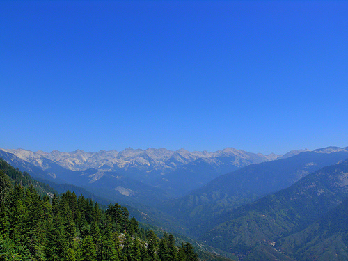
Sequoia National Park is located largely in the Sierra Nevada. The
park's mountainous landscape includes the tallest mountain in the
continental United States, Mount Whitney, which stands at 4,421 m above
sea level. The Great Western Divide runs parallel to the Sierran Ridge
and can be seen in various places in the park, for example, Mineral
King, Moro Rock or the Giant Forest. The peaks of the Great Western
Divide rise to over 3,700 m. Deep canyons are found between the
mountains, including the Tokopah Valley above Lodgepole, Deep Canyon on
the marble bedrock of the Kaweah River, and Kern River Canyon in the
park's hinterland, which reach over 1,500 m deep over 50 km.
Most
of the mountains and canyons of the Sierra Nevada are composed of
granodiorite rocks. These rocks, like granite, diorite and monzonite
were formed when molten rock cooled far below the surface of the earth.
The molten rock was the result of a geological process known as
subduction. Powerful ground forces forced the landmass under the waters
of the Pacific Ocean under and below an advancing North American plate.
Very hot water driven by the underlying ocean floor migrated upwards and
melted the rock as it went. This process took place during the
Cretaceous period, 100 million years ago. Granite rocks have a mottled
salt and pepper appearance as they contain various minerals including
quartz, feldspar and mica. The Valhalla are prominent granite cliffs
that rise above the waters above the fork of the Kaweah River.
The Sierra Nevada is a young mountain range that is probably no more
than 10 million years old. Land forces, probably associated with the
development of the Great Basin, forced the mountains to rise. Over the
past 10 million years, at least four ice ages have covered the mountains
with a thick blanket of ice. Glaciers form and grow during long periods
of cool, wet weather. Glaciers move very slowly through the mountains,
carving deep valleys and steep peaks. The long history of glaciation in
the range and the erosion-resistant nature of the granitic rocks that
make up most of the Sierra Nevada have together created a landscape of
hanging valleys, waterfalls, rugged peaks, alpine lakes and canyons
glaciers.
The caves in the park, like most caves in the Sierra
Nevada of California, are primarily karst caves dissolved from marble.
The marble rock is essentially composed of limestone which has been
metamorphosed by the heat and pressure of the formation and uplift of
the Sierra Nevada Batholith. The latter's rapid uplift over the past 10
million years has resulted in rapid erosion of metamorphic rocks at the
highest elevations, exposing the granite below. Therefore, most caves in
the Sierra Nevada are in the middle and lower elevations (below 7,000
feet or 2,100 m), although some caves are found in the park at
elevations up to 10,000 feet ( 3,000 m) such as the “White Chief” cave
and the “Circus Cave in Mineral King”. These caves are carved into the
rock by the abundant seasonal streams in the park. Most of the larger
caves in the park have or have had streams flowing through them.
The park contains over 270 known caves, including Lilburn Cave which is
the longest cave in California with nearly 17 miles (27 km) of studied
passages. The only commercial cave open to park visitors is the Crystal
Cave which is the second longest cave in the park at over 3.4 miles (5.5
km). Crystal Cave was discovered on April 28, 1918 by Alex Medley and
Cassius Webster. The cave is at 9°C and is only accessible by guided
tour.
Caves are discovered every year in the park, with the
largest cave discovered being Ursa Minor (cave) in August 2006.
The area is also home to abundant wildlife: bobcats, foxes, coyotes, American badgers, wolverines, beavers, ground squirrels, possums, rattlesnakes and mule deer are commonly seen, and more rarely , cougars. There are plans to reintroduce bighorn sheep to the park.
The accommodation available in the park is varied. It includes a
lodge, the Wuksachi Lodge, but also mountain refuges such as the Pear
Lake ski refuge. There are especially several campgrounds.
Reforestation in New Zealand
California Redwoods have helped reforest
6 hectares, (15 acres) of the Redwood Forest, Whakarewarewa, as part of
a program to assess the viability of various exotic tree species for New
Zealand forestation .