Location: Northwest California Map
Area: 957,590 acres
Official site
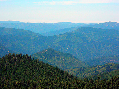
Six Rivers National Forest is a vast and diverse expanse of public land in the rugged northwestern corner of California, renowned for its dramatic coastal mountains, wild rivers, ancient old-growth forests, and rich biodiversity. Spanning nearly 1 million acres (957,590 acres or 3,875 km² of National Forest System lands), it offers a mosaic of ecosystems from coastal redwood groves to alpine meadows, providing uncrowded opportunities for recreation, solitude, and connection with nature. Managed by the U.S. Forest Service (part of the USDA), the forest is named after the six major rivers that originate or flow through it: the Smith, Klamath, Trinity, Mad, Van Duzen, and Eel Rivers. These waterways, totaling 366 miles of designated Wild and Scenic Rivers, are the lifeblood of the area, supporting world-class fishing, whitewater rafting, and scenic beauty. The forest's remote, mountainous terrain—from sea level to peaks approaching 7,000 feet—creates a sense of wild isolation, while its cultural significance includes sacred sites for numerous Native American tribes. Established in 1947, Six Rivers balances multiple uses like timber harvesting, wildlife habitat protection, and outdoor recreation, but it faces ongoing challenges from wildfires, climate change, and resource management debates.
Six Rivers National Forest stretches along California's North Coast, primarily in Del Norte, Humboldt, Trinity, and Siskiyou counties, extending from the Oregon border southward for about 140 miles. It borders Redwood National and State Parks to the west, Klamath National Forest to the east, and Shasta-Trinity National Forest to the southeast, forming part of a larger network of protected wildlands that includes Siuslaw National Forest across the state line. The forest headquarters are in Eureka (Humboldt County), with four ranger districts: Gasquet (northern, focusing on Smith River), Orleans (central, Klamath River area), Mad River (southern interior), and Willow Creek/Lower Trinity (western, near the Eel River). Bridgeville serves as an additional outpost. Access is via U.S. Highway 101 along the coast, State Highway 299 through the interior mountains, and remote gravel roads like the Redwood Highway. The nearest major cities are Eureka (population ~27,000) and Crescent City (near the northern boundary). Elevations range from sea level at the Pacific coast to 6,329 feet at Granite Peak, with the terrain divided into coastal lowlands, steep coastal ranges, and inland plateaus.
Geologically, Six Rivers lies within the Klamath Mountains
physiographic province, a complex uplift of ancient metamorphic and
igneous rocks dating back 150-400 million years, overlaid by younger
sedimentary layers from the Cretaceous period. Erosion by the six rivers
has carved deep canyons, V-shaped valleys, and terraced floodplains,
exposing Franciscan Complex rocks (including serpentinite and
radiolarian chert) that contribute to the area's unstable soils and
frequent landslides. The forest encompasses diverse landforms: coastal
dunes and bluffs in the Smith River National Recreation Area (SRNRA,
84,000 acres in the north), rugged granitic peaks in the interior like
the Siskiyou Wilderness, and karst features such as marble caves near
the Mad River. The Smith River, the largest undammed river in
California, flows through pristine coastal watersheds with clear,
emerald waters ideal for anadromous fish migration.
The climate is
maritime-influenced, with mild, wet winters (average 40-50 inches of
rain annually, up to 100 inches in coastal areas) and cool, foggy
summers (highs 60-80°F). Higher elevations see snowpack from November to
April, while coastal fog sustains redwood ecosystems year-round. Climate
change trends include warmer temperatures (up 2-3°F since 1900), reduced
snowpack, prolonged droughts, and increased wildfire risk, exacerbating
invasive species and habitat shifts. Ecosystems transition from
temperate rainforest (coastal redwoods up to 300 feet tall) to mixed
conifer forests (Douglas-fir, ponderosa pine), oak woodlands, and
montane chaparral. Six botanical areas highlight rare plants like the
Kalmiopsis leachiana (a rare wildflower in serpentine soils). The forest
includes 137,000 acres of old-growth forest, with dominant species like
coast redwood (Sequoia sempervirens), Douglas-fir (Pseudotsuga
menziesii), tanoak (Notholithocarpus densiflorus), Pacific madrone
(Arbutus menziesii), and white fir (Abies concolor).
Six Rivers is a biodiversity hotspot, supporting over 1,500 plant
species and serving as a critical corridor for wildlife migration
between coastal and inland habitats. Flora includes endemic species
adapted to ultramafic (serpentine) soils, such as the Port Orford cedar
(Chamaecyparis lawsoniana), threatened by root rot disease. The forest's
old-growth stands provide carbon sequestration and habitat complexity,
while riparian zones along the rivers foster lush understories of ferns,
salmonberry, and wild ginger.
Wildlife is abundant and diverse: black
bears, Roosevelt elk, and mountain lions roam the uplands; river otters,
bald eagles, and ospreys thrive along waterways; and the marbled
murrelet (a threatened seabird) nests in old-growth canopies. The forest
is prime habitat for the federally threatened northern spotted owl and
coho salmon, with 785 miles of fish-bearing streams stocked by the
state. Rare species include the Siskiyou Mountains salamander and Del
Norte red tree vole. Five wilderness areas—Yolla Bolly-Middle Eel
(shared), Big Flat, Black Lassic, Siskiyou, and Mount Lassic—total over
100,000 acres of pristine habitat protected under the 1964 Wilderness
Act. Conservation efforts focus on ecosystem management under the 1994
Northwest Forest Plan, which reduced timber harvests to protect
late-successional reserves for old-growth dependent species.
The lands of Six Rivers have been inhabited by Indigenous peoples for
over 10,000 years, including the Yurok, Karuk, Hupa, Tolowa, Hoopa,
Chilula, and Wailaki tribes, who used the area for fishing, hunting,
acorn gathering, and cultural ceremonies. Sacred sites, such as
high-country prayer seats and burial grounds, dot the landscape, with
traditional burning practices maintaining meadows and oak
savannas—practices often misunderstood by early settlers as arson.
European exploration began in the 1820s with fur trappers, followed by
gold rushes in the 1850s that decimated salmon runs and displaced tribes
through violence and treaties (e.g., the 1851 unratified Hoopa Treaty).
Logging boomed in the late 1800s, targeting redwoods for coastal mills.
The precursor forests—Klamath (1905), Siskiyou (1906), and Trinity
(1905)—were established under the 1891 Forest Reserves Act to curb
overexploitation. The Civilian Conservation Corps (CCC) in the 1930s
built trails, ranger stations, and campgrounds, shifting focus to
recreation.
Six Rivers was formally created on June 3, 1947, by
President Harry S. Truman's Proclamation 2733, consolidating 900,000
acres from the three parent forests plus the Northern Redwood Purchase
Unit (NRPU, acquired 1939-1945 under the Weeks Act to stabilize the
timber industry). The name "Six Rivers" was suggested by author Peter B.
Kyne in 1946, derived from the Spanish "Cincos Rios." Early management
under Supervisor William F. Fischer emphasized timber (projected 125
million board feet annually) and road-building, with the 1948
Preliminary Timber Management Policy promoting sustained yield.
Post-WWII timber demands led to clear-cutting and even-aged management,
but the 1964 "Thousand Year Flood" (caused by atmospheric rivers)
highlighted watershed degradation, spurring restoration.
The 1960
Multiple-Use Sustained-Yield Act codified balanced uses, while the 1968
Redwood National Park Act curtailed NRPU logging. Native relations
evolved from tensions (e.g., 1949 arson accusations) to legal
protections: the 1983 ruling in Northwest Indian Cemetery Protective
Association v. Peterson halted the G-O Road through sacred Chimney Rock
sites under First Amendment rights, affirmed by the 1988 Supreme Court
case Lyng v. Northwest Indian Cemetery Protective Association (though
the road proceeded with mitigations). The 1988 Hoopa-Yurok Settlement
Act resolved land claims, transferring sites like the Yurok Redwood
Experimental Forest. By the 1990s, the northern spotted owl lawsuit and
1994 Northwest Forest Plan shifted to ecosystem-based management,
reducing harvests to under 15.5 million board feet annually. The 1995
Land and Resource Management Plan (updated periodically) guides current
practices.
Six Rivers excels in water-based and backcountry recreation,
attracting anglers, boaters, and hikers seeking solitude. The Smith
River offers Class III-IV whitewater rafting and kayaking on its
undammed stretches, while the Klamath and Trinity provide steelhead and
salmon fishing (peak fall/winter). Over 475 miles of trails include the
challenging 13-mile Redwood National Park to Prairie Creek Redwoods loop
and the remote Siskiyou Wilderness paths for backpacking. Camping
options abound: 63 developed sites (e.g., Patrick's Point with ocean
views) and dispersed backcountry spots, plus 109,000 annual visitors
pre-1960s (now millions regionally). Other activities: mountain biking
on the Coastal Trail, OHV routes in the Mad River district, rockhounding
for jade and agates along the Smith, and winter snowshoeing or limited
skiing at Grouse Mountain Lookout (historic site, no lifts).
Access
requires a Northwest Forest Pass ($5/day or $30/year) for some
trailheads; no permits needed for day use, but wilderness entry follows
Leave No Trace principles. Roads like Forest Highway 17 (G-O Road, paved
but winding) connect districts, but many are gravel—high-clearance
vehicles recommended. Pets allowed on leash; drones prohibited in
wilderness. Guided tours via outfitters like Humboldt Redwoods State
Park partners enhance rafting safety.
Administered from Eureka with ~66 permanent and 550 seasonal staff, the forest operates under the 1995 LRMP, emphasizing ecosystem health over commodity production. Timber remains key (9% of lands suitable, ~15 million board feet/year), but priorities include fire resilience (prescribed burns post-1964 flood lessons), invasive species control (e.g., Port Orford cedar root disease), and habitat restoration for threatened species. The SRNRA (designated 1978) protects the Smith River watershed from logging and mining. Native consultations are government-to-government with tribes like Yurok and Karuk, addressing herbicides and cultural sites. Climate adaptation includes monitoring trends like increased fire severity (e.g., 2020 fires burned 10% of the forest).
The prime season is May-October for mild weather (50-70°F days, cooler nights) and low rivers for hiking/fishing, though summer crowds peak July-August. Winter (Nov-April) suits storm-watching and steelhead angling but brings heavy rain (risk of flooding) and road closures. Spring wildflowers bloom March-May. Always check fire restrictions—Level 1 (campfires in designated rings only) from August 1-November 1, 2025. Pack rain gear, bug spray (mosquitoes in riparian areas), and bear-proof food storage. Prepare for variable conditions: download offline maps (cell service spotty), carry 1 gallon water/person/day, and inform someone of your itinerary—rescues can take hours in remote areas. No alcohol bans, but follow fire rules; hunting seasons (deer, bear) require state licenses.
As of September 9, 2025, the forest is under Level 1 fire restrictions due to dry conditions, prohibiting wood/ charcoal fires outside developed sites and limiting smoking to vehicles/trails. The Dillon Fire (7,706 acres, 7% contained) in the Klamath River area has prompted a full closure order for the vicinity (Ti-Bar area), affecting recreation sites, trails, and roads—structures protected, but evacuations possible. The Log Fire closure (Sep 2-20) impacts specific northern sites. Monitor InciWeb or the Forest Service hotline (707-574-6233) for updates; virtual meetings addressed weather concerns. No widespread closures, but avoid fire perimeters—air quality may be poor from smoke.
The forest starred in the 1967 Patterson-Gimlin film, purportedly
showing Bigfoot near Bluff Creek in the Orleans district— a cornerstone
of cryptozoology lore.
Jerry Garcia's father drowned in the Trinity
River here in 1947, an event that influenced the Grateful Dead founder's
life (though disputed by some).
The Smith River is California's only
major undammed coastal river, home to the rare pygmy whitefish.
Over
100 archaeological sites document 8,000+ years of Indigenous use,
including petroglyphs and fish weirs.
The 1988 Supreme Court case on
sacred lands set precedents for religious freedom vs. federal
development.
Despite its youth (established 1947), the forest manages
1.1 million acres total (including private inholdings) and produces 30
million seedlings annually at the Humboldt Tree Nursery for
reforestation.
Six Rivers National Forest embodies the wild
spirit of California's North Coast, rewarding prepared visitors with
profound natural and cultural experiences while underscoring the
delicate balance of conservation in a changing climate.
