Location: Bolívar State Map
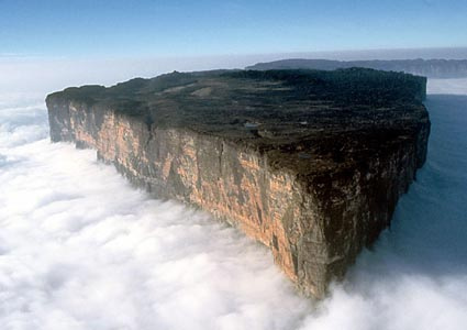
Mount Roraima, also known as Cerro Roraima in Spanish and Monte Roraímã in Portuguese, is the highest tepui (table-top mountain) in the Pakaraima chain of the Guiana Highlands, standing at 2,810 meters (9,220 feet) above sea level at its peak. This ancient geological formation, often described as a "lost world" isolated for millions of years, marks the tripoint border junction of Venezuela (85% of the area), Brazil (5%), and Guyana (10%), with its flat summit spanning 31–50 square kilometers (13–19 square miles). Located in the remote Gran Sabana region within Venezuela's Canaima National Park, it is a UNESCO World Heritage site renowned for its sheer cliffs rising 400–1,000 meters (1,300–3,300 feet), crystal-clear pools, cascading waterfalls, and an otherworldly landscape that has inspired legends and literature, including Arthur Conan Doyle's The Lost World. As one of the oldest geological formations on Earth, dating back 1.7–2 billion years, Mount Roraima serves as a vital hydrological source, feeding rivers in Guyana and contributing to the Amazon and Orinoco basins, while embodying the indigenous Pemón people's view of it as the "house of the gods."
Geographically, Mount Roraima is a massive mesa about 14 kilometers
(9 miles) long and 5 kilometers (3 miles) wide, with an average
summit elevation of 2,600–2,700 meters (8,500–8,900 feet). Formed
from Proterozoic sandstone (primarily quartzite with 98% silica
content) atop a granite and gneiss base, it is part of the ancient
Guiana Shield on the northern edge of the South American Plate.
Tectonic uplift, erosion, and weathering over 180 million years have
sculpted its vertical cliffs, flat tabletop summit, erosional
potholes, tafoni (honeycomb-like structures), and a pseudo-karst
surface with extensive caves, including the world's largest quartz
cave system over 15 kilometers long and 73 meters deep. Waterfalls
like Crystal Valley Falls and Triple Point Falls cascade from its
edges, and the summit features unique rock formations, gorges, and
pools shaped by intense rainfall and glacial activity from the
Pleistocene epoch. The soils are highly acidic and nutrient-poor,
leading to sparse vegetation on the plateau.
The climate is
tropical at the base but cooler and wetter on the summit, with
frequent fog, mist, and heavy rainfall (up to 4,000 mm annually),
creating a perpetually humid environment. Temperatures range from
warm and humid lows at the forested base to chilly highs on the
plateau, with strong winds, storms, and high UV exposure during
clear spells. The wet season (May–August) amplifies waterfalls and
river crossings, while the dry season (September–April) offers
better trekking conditions but still unpredictable weather.
Mount Roraima's history dates to indigenous Pemón peoples, who named
it ("roroi" meaning "blue-green" and "ma" meaning "great") and
likely ascended it before Europeans, viewing it as a sacred site and
"house of the gods" tied to creation myths. European awareness began
in 1595 when Sir Walter Raleigh described it as an "immeasurable
crystal mountain" with waterfalls during his El Dorado quest.
Scientific exploration started in 1838 with Robert Hermann
Schomburgk, followed by boundary surveys in 1840. The first recorded
ascent was in 1884 by Everard im Thurn and Harry Perkins, aided by
Pemón guides, though locals may have known routes earlier. Later
expeditions focused on botany, zoology, and geology, with its
isolation inspiring Doyle's 1912 novel.
Culturally, it holds deep
significance for Pemón communities, symbolizing spiritual power and
ancestral heritage, with legends of gods and forbidden realms.
Today, it represents regional identity in Venezuela, Brazil, and
Guyana, blending indigenous traditions with global fascination.
Mount Roraima's isolated summit hosts a megadiverse, endemic-rich
ecosystem, often called a "living museum" due to millions of years
of separation. Flora: The base features evergreen rainforests with
tall trees (25–45 meters) from families like Arecaceae and
Astragalus, transitioning to bromeliads on cliffs and carnivorous
plants on the plateau, including endemic Heliamphora nutans (pitcher
plants), Drosera felix (sundews), Utricularia quelchii
(bladderworts), orchids, and epiphytes adapted to nutrient-poor,
acidic soils. Wet and dry savannas, bare rocks, and forests create a
mosaic of habitats.
Fauna: The base supports mammals like sloths,
anteaters, tapirs, primates, jaguars, and capybaras; birds including
falcons, parrots, endemic hummingbirds, and harpy eagles; and
diverse reptiles, amphibians, and insects. The summit has rarer
species, with caves hosting bats, grasshoppers, spiders, centipedes,
and unique invertebrates. Many species remain undiscovered or at
risk due to the fragile environment.
As part of Canaima National Park (a UNESCO World Heritage site), Mount Roraima is protected to preserve its unique geology, biodiversity, and hydrological role, with a monthly visitor quota of 200 to limit impacts. Threats include tourism-related pollution (e.g., fuel and organic waste causing microbial imbalances in caves), climate change affecting endemic species, and potential habitat disruption from increased access. Conservation efforts focus on regulated hiking, monitoring ecosystems, and involving indigenous Pemón communities in management, ensuring the site's role in regional biodiversity corridors and global heritage.
Attractions include the surreal summit landscape with black rocks, crystal pools, gorges, wildflower gardens, and viewpoints like Triple Point (border junction) and Maverick Rock (highest point). Waterfalls, caves, and rock formations offer exploration, while the base provides rainforest hikes. Activities center on multi-day trekking (3–9 days), camping at base and summit camps, birdwatching, photography, and wildlife observation. No technical climbing is needed for the natural ramp ascent, but the trek involves river crossings and steep sections.
Access is primarily from Venezuela's Santa Elena de Uairén (near the Brazil border), with tours starting there; Brazil and Guyana routes involve longer forest hikes or airstrips. Treks last 3–9 days, organized by agencies like Vago Tours, Akanan Amazing Adventures, or Hike Venezuela (costs ~USD 300–500, including meals and porters). Best time: Dry season (September–April) for safer trails; wet season (May–August) enhances waterfalls but increases risks like flooding. Preparations: Good physical fitness, hire porters for gear (8–10 kg backpack ideal), pack waterproof jacket, quick-dry shoes, snacks, sleeping bag, lantern, and cash (no signal or cards). Tips: Use guides for safety, acclimatize to weather extremes, bring UV protection and insect repellent, support locals via porters, and follow low-impact rules to protect the fragile ecosystem. As of 2025, it remains a top-rated destination, with ongoing popularity and Travelers’ Choice awards.