Location: Bolivar State
Length 723 km (449 mi)
Río Caura or River Caura is one of the tributaries of the Orinoco River located in the Bolívar State of Venezuela. It reaches a length of 723 km (449 mi). Local indigenous tribes of Sanema and Ye'kuana people still live along the shores of River Caura. River Caura is most famous for its second largest waterfall in the World known as El Salto Para also known as Kuyuwishodu as it is called by the local natives. It is situated about 257 km upstream of River Caura from a point where it joins Orinoco river. It is not very high. Its seven cascades reach a total length of 64 meters, but its width was estimated to be 5608 meters. You can get a tour from a nearest settlement of El Playon. El Salto Para Waterfall also establishes a border between upper and lower Caura. The easiest way to view jungle wild life is by taking a boat from Maripa, travel along Orinoco and then Caura River. One of the curious aspects of this region is lack of clouds so you have less chance to get soaked by rain, but it is still advisable to take some type of raincoat or a poncho.
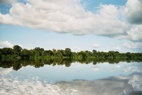
The microclimate created by the waters of the Caura
The Caura
River, due to its great flow, is a cloudless river in the morning hours
as is the case with the Orinoco itself, a phenomenon visible in
satellite images and that is explained in the article on diathermancy.
In its basin there are very high sandstone plateaus with abundant
rainfall, such as the Jaua and Sarisariñama plateaus. In the latter are
the Sarisariñama abysses, curious formations similar to the deep and
wide wells that form in karstic regions, with the exception that here
they are sandstone plateaus.
The Upper Caura
In its
beginnings, the upper course of the Caura receives the name of Merevari,
and it is a plateau river, with numerous jumps and streams in a
staggered manner, in which said streams are linked with stretches with a
much smaller difference in level. The source of the Merevari is located
to the south of the Meseta de Jaua, which is partly surrounded by its
left bank and a series of hills of about 1000 m altitude, which serve as
a watershed divider, in addition to that of the Merevari or Caura, the
of the Ventuari river, in the state of Amazonas, that of the Padamo,
also in the state of Amazonas, and that of the Labarejuri river, a
Brazilian river, already in the basin of the Rio Branco (White River), a
tributary of the Amazon. The Merevari descends about 239 meters in about
80 km before joining the Caura proper.
The Middle Caura
The
middle section of the Caura River can be located between the confluence
of the Merevari (or rather, from the point where the Merevari is renamed
Caura) and the Salto Pará, which would be included in this section. It
has several streams, such as the Bucade and the Carapo and receives its
main tributary, the Erebato River. The direction of the river in this
section is significantly south-north and it gradually increases in flow
due to the boxing in a wide valley surrounded by high plateaus (tepuyes)
with high rainfall (about 2,500 mm or more)
The river Erebate
It is born on the Uasadi-jidi plateau and runs for almost 100 km with a
steep slope with streams that can be seen in satellite images before
joining the Abadú River, its southernmost tributary, and from this
confluence it runs about 200 km before its confluence. with the Caura.
It is also a plateau river, although largely navigable and with numerous
meanders and oxbow lakes before its mouth in the Caura. Its most
important population, Santa María de Erebato, is a mission town, like
most of the populations of the Venezuelan Guayana. An attempt was made
to develop coffee cultivation in this region, although probably with
little success, given the enormous distances traveled by river to sell
the production and also because of the low population in the area.
Para jump
The Caura River has great tourist importance and
enormous hydroelectric potential, mainly in the Salto Pará, which is
located 257 km from the Orinoco, 195 from Maripa and 50 km downstream
from the confluence of the Erebato with the Caura itself, therefore
which is already at a point where it is very abundant. A few kilometers
before the Pará Falls, the Caura divides into two main arms and other
smaller ones at the point where a steep slope begins, with streams and
small falls and it is when they meet again, when the true Pará Falls
appear, of dimensions notable more for its volume than for its height.
In total, the previous rapids of the Pará waterfall, plus the waterfall
itself, have a drop of 168 m along 7 km of land travel, according to
Pablo Vila. In the area there is an excellent tourist place in the Sucre
municipality of the state Bolívar (Maripa) known as the Caura Basin.
To get to the Caura River you can go from the Orinoco by boat; also
by land, from Ciudad Bolívar to Maripa and going up the Caura River by
boat to Salto Pará, of great scenic interest; and also by air, by
private plane to the tourist camp on the banks of the Caura or by
commercial plane from Ciudad Bolívar and then by land to any part of the
river where you want.