Aconcagua Provincial Park is located in the province of Mendoza in Argentina.
Location: 115 mi (185 km) West of Mendoza Map
Open: 8am- 6pm daily
Info: Ranger station, Horcones
Tel. (0261) 156 210 118
Permits: Mendoza (0261) 4252 090
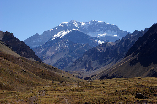
Aconcagua Provincial Park takes its name from quechua word of “Ackon-Cauak”, which roughtly is translated as ‘Stone Sentinel’. Splendid Andes Mountain Range draws all types of thrill seekers ranging in difficulty including hiking, climbing, skiing and etc. Besides it draws history lovers. This range plays an important place in the history of Latin America. In 1818 General Don Jose de San Martin crossed these mountains during war with the Spanish Empire eventually securing independence for Chile by his daring raid. The summit of the mountain Aconcague, the tallest mount in the Andes range, was considered unattainable for many years until January 14, 1897, then Matías Zurbriggen, a member of the Fitzgerald expedition finally reached it. Since then many climbers made the same ascent to the top of Aconcagua Provincial Park. Needless to say it is a dangerous endeavor that requires stamina and experience. Some of the more visited attractions that draw tourists all year long besides Mount Aconcagua are Horcones Lagoona and Plaza de Mulas or Plaza Francia.
Any one that travels to the region of Aconcagua Provincial Park should take into account that it is a dangerous and isolated region of the country. The closest you will get to civilization is town of Puente del Inca located about 4 km or 3.5 miles from the park. Furthermore high altitude sickness is fairly common. It is a general condition that is marked by nausea, headaches, light headiness and etc. Try to take medications for headaches and migraines. Additionally drink plenty of water. If you are not accustomed to the mountains your trip to this majestic natural marvel can easily turn into a nightmare. Prepare yourself accordingly. You won't regret coming here.
If you travel with kids under 12 you have to take into consideration that they will not be allowed beyond Quebrada de Durazn. If you have minors (14-21) they will need signed agreement by both parents that they are fit to for the conditions of the Andes mountains.
Area: 65,690 ha, and next to Aconcagua, there is a set of snow-capped
peaks that exceed 5,000 meters above sea level: Dedos, Tolosa, México,
Almacenes, Ameguino, Cuerno, Pan de Azúcar, Cúpula Güssfeldt, La Mano
and Catedral.
The Aconcagua, Watchtower or Sentinel of Stone (Quechua
word), shows imposing flanks, glaciers, needles or ice penitents, large
hauls, underground rivers, streams, hanging glaciers, and eternal snow.
On the Aconcagua hill, the relative humidity is low and the oxygen
pressure also decreases for the same reason. Winds produce low pressure
zones that intensify these effects. It must be taken into account that
the Base Camps, from which the ascent begins, are located at more than
4,200 meters above sea level.
In 1883, the German Paul Güssfeldt, in
adverse conditions, reached 6560 meters above sea level
On January
14, 1897, the Swiss Mathias Zurbriggen reaches the summit.
The geological-structural constitution of the mountain range is
complex and for its analysis it can be divided into three
sufficiently differentiated parts. One of them is the one that
extends approximately between parallels 28º and 34º, a portion that
in turn can be subdivided into two parallel cords, one eastern
called Cordillera Frontal and the other western, where the Aconcagua
Provincial Park is located, which leads name Cordillera Principal or
the Limit, which is about 70 km wide to the south of the Diamante
River and narrows towards the north, where it only reaches 30 km in
the region of the prospected Park. It is significant to clarify that
these two chains do not have a well-defined division between them,
except for a few small stretches, and that both sections are
perfectly linked to each other. The main difference between them is
the type of rocks that compose it. The Cordillera Principal is
formed by layers of marine sediments with Jurassic and Cretaceous
fossils and pyroclastic rocks on the western side (González
Bonorino, 1958). At the same time, it is separated from the
Precordillera – a different mountainous formation – by several
valleys, which, at the height of the surveyed area, is Uspallata,
which fulfills this purpose.
Mount Aconcagua is located at
the southern end of the chain called Los Penitentes, and with its
6,960.8 meters above sea level, it has the attribute of being the
highest elevation in the world outside the Himalayan system. Its
great height, like that of other nearby hills, does not correspond
to active volcanic structures such as Tupungato, but its current
altitude results from the tectonic uplift of the mountain range. It
is guarded by high-rise colossi such as Cerro Catedral to the
northwest at 5,200 meters above sea level, El Cuerno (5,450 meters
above sea level), Bonete (5,100 meters above sea level) and others
located in the Upper Horcones Valley. In the so-called Valle de los
Horcones Inferior are the Ibáñez hills (5,200 masl), the Mirador
hill (5,800 masl) among the highest. Between 27º and 33º30' no
Quaternary volcanism is observed and seismic activity is
concentrated in a thin strip along the western edge, which coincides
with the most active geotectonic zone where large earthquakes occur.
A remarkable feature is that only the very high peaks are
covered by glaciers, which took place during a series of advances
that occurred during the Quaternary, given that the lower limit of
eternal snow is very high due to aridity and strong insolation. This
gives rise to the erection of the penitents, a very characteristic
formation of this area of the Andes, consisting of mounds of snow
about 3 meters high with the appearance of monks, caused by the
melting of the superficial layers of snow due to the strong
insolation that by forming furrows that deepen over time, the area
is covered with those sharp aligned mounds. These formations, due to
their appearance, give their name to the Los Penitentes chain of
elevations.
Drainage occurs on high peaks such as Aconcagua
through a long network to which the melting of ice and snow is
added, which forms a very dense material that frequently favors
debris slopes.
The "stone sentinel", meaning the origin of
the word Aconcagua in the Quichua language, is about 12 km from the
border with the sister Republic of Chile and its coordinates are 32°
39' Lat.S and 70° 01' Long. O. (Atlas I.G.M., 1998). There are
71,000 ha of dry, arid environment, mountainous terrain with little
vegetation on the slopes and where the foothills form extensive
ridges separated by huge valleys whose height sometimes drops to
2,000 meters above sea level. On the southern wall and also on the
one facing east, the Aconcagua hill presents impressive glaciers
such as the so-called Polaco that runs along this slope between
approximately 6,900 and 5,900 meters above sea level, with an
extension close to 700 ha, and the Güssfeld, with considerably more
extension. than the previous one. One of the largest in the area is
the La Vacas glacier with almost 2000 ha.
The glacial action
was much greater in the past and the geomorphology that can be seen
today is modified by the action of subsequent processes such as mass
removal and fluvial action. The current glaciers of the Andean zone
in general, which therefore affect the Aconcagua Provincial Park,
are classified as valley glaciers, mountain glaciers and snow
patches; these, in turn, can appear as uncovered, covered by debris
and debris glaciers.
Almost the entire fluvial network of Mendoza corresponds to the
Desaguadero basin formed by the Mendoza, Tunuyán, Diamante and Atuel
rivers. Only in the southern part, the Barrancas and Grande rivers that
form the Colorado, do not integrate the aforementioned basin.
All
these water courses are born in the mountainous area and descend to the
plains where they interrupt their basins due to the intense use made of
them for irrigation. They are antecedent rivers (which conserved their
courses since before the orographic formations) that cross the mountains
by means of enormous gorges eroded during the tertiary movements and
practically many of them lack water for a good part of the year and with
the spring thaw their channels They make very torrential.
The
Mendoza River is formed from the union of the Tupungato and Cuevas
rivers and receives the waters of the Horcones, Santa María and Vacas
rivers that descend from Aconcagua. Note the difference in the flow of a
river that is fed by melting ice, such as the Mendoza, comparing its
average flow, calculated at approximately 55 m³/s, with the 750 m³/s
that it reaches in the summer.
The Aconcagua Provincial Park is
surrounded to the west and southwest by the Horcones River, which runs
through the valley of the same name, and part of the northern and
eastern sectors by the Vacas River. On the eastern slopes, the Relinchos
stream is born, which after a short journey feeds the Vacas river.
There are no glacial lakes and we only see some remnants of them in
the form of small basins in the high mountains.
Laguna de los
Horcones is the most important water mirror in the preserved area. The
glaciers, those huge masses of ice that occupy the highest parts of the
massifs, have their maximum expression in the conservation unit.
Two are found on the southern slopes (inferior Horcones and superior
Horcones glaciers) and the resulting ones on the North and Northeast
slopes, the main one being Las Vacas, located at the head of the
homonymous river.
On the southern and eastern walls, the
aforementioned Glaciar de los Polaco stands out, with an area that
reaches 700 hectares, and the Güssfeld glacier with an area that exceeds
1000 hectares.
The climate that affects the protected area that we analyzed can be
classified as temperate semi-arid mountain. It is characterized by the
irregularity of the Atlantic rainfall pattern, which is marked by the
variations that, in this aspect, the area suffers from receiving
climatic influence from the Atlantic domain, with summer rains, and from
the Pacific domain with its predominantly winter rainfall.
Despite the great distance that separates it from the Atlantic, this
part of the mountains receives from this sector the scarce humidity that
generally falls in the form of large snowfalls in the highest parts,
mainly during the months of May to August. Its frequency and magnitude
decrease towards the east.
From the Pacific, the climate receives
the greatest influence due to the action of the Pacific anticyclone that
generates westerly winds. These winds rise and when they collide with
the hills of the mountain range they cool down and precipitate their
humidity in the form of snow. The Chilean coast is affected by two
well-differentiated currents, the Humboldt current, which is cold and
bathes the coasts of the northern sector, and the Patagonian, temperate,
those of the southern sector. Both, depending on the origin of the wind,
influence the area, although to a much greater extent the winds from the
southwest sector.
In the mountain range, the rise of the air is
markedly through the valleys and the slopes of the hills and due to the
low pressure that exists in the summits, this air generally rises during
the afternoons and forms cumulus clouds but they do not occur. At night
the opposite phenomenon occurs and the wind blows from the top towards
the valleys.
Like all regions with marked altitude variations,
temperature is a climatic factor totally dependent on them.
In
the entire Cuyo mountain range, strong cold winds from the west and
southwest sectors occur in winter, which when they blow together with
snowfalls, the so feared white wind is formed. These same winds, under
particular atmospheric conditions, cross the antes, undergoing sudden
changes that transform them when they reach the lowlands into hot and
dry ones, as occurs with the folkloric zonda wind.
As for the
summer temperatures, it must be taken into account that during the
nights, above 5000 masl, -20 °C is not an exceptional value and at the
top it reaches -30 C°. In Plaza de Mulas, at times of bad weather, -18
C° is usually recorded. During the winter the area is very covered with
snow and the temperature rarely exceeds 0 C°
According to Cabrera (1976), the area where the Aconcagua Provincial
Park is located makes it possible to clarify it phytogeographically, in
what he calls the high Andean phytogeographic province, which
encompasses all the high mountains that are located to the west of
Argentina from Bolivian territory to Tierra del Fuego. Depending on the
latitude, this biome is sectorized into districts, calling the Cuyo high
Andean phytogeographic district the one that occupies the Andes of the
provinces of San Juan and Mendoza. In the area of this park, the
classification made by PRODIA (1999) does not differ too much from the
one mentioned above.
In any phytogeographical district, the
vegetation is highly influenced by the climate, in this case it is the
cold and dry of the Mendoza Andes, which is why scarce shrubby, stunted
or creeping vegetation predominates on the steep slopes, and in the
areas near the peaks , the dominant vegetation is the bushy steppe, low
and scattered, with a predominance of the iros, which are compact
thickets of hard shepherd, generally yellowish, often belonging to the
Stipa and Poa genera.
In the highest areas, there are generally
rocky areas where the hostility of the climate prevents the development
of any type of vegetation. Only some plants are observed in the humid
areas that are formed by some hollowness in the ground or features of
the relief that favor the permanence of humidity. In these places –
called fertile plains – few grasslands grow made up of vegetables from
the families of sedges and rushes. Descending, some plants appear that
mainly represent the compound families such as Caliceraceae,
Portulacaceae, Legumes and Verbenaceae. When we descend in height, some
woody species appear, the most common to observe is the goat's horn
(Adesmia subterranea), which develops just over a meter in height. All
the flora develops its life cycle suddenly and for the short time in
which the climatic conditions reduce its rigor.
If in the item referring to the flora it was said that the adverse
environmental conditions for the development of life notoriously
conspired against its abundance, the same criterion can be applied to
the fauna. Few species have achieved evolutionary adaptations to
compensate or adapt to the lack of water, sufficient vegetation cover,
very low temperatures, little oxygen in the air, the strong and constant
wind, among other adverse factors.
Without keeping a systematic
order, mention will be made of the main species of each faunal group
—within the vertebrates— that inhabit these latitudes, also taking into
account that the conditions of the terrain and the climate make an
exhaustive survey of the fauna difficult.
The condor (Vultur
gryphus), which with a wingspan of nearly three meters and a height that
exceeds 90 centimeters when perched, is considered the largest flying
bird, flies with extraordinary skill over the valleys and hills of the
surveyed area. He alone constitutes a highly attractive element for
visitors. Continuing with the group of birds, it is opportune to clarify
that the high Andean region has several endemisms such as the gray
sleeper (Muscisaxicola cinereus) that frequents the vicinity of mountain
rivers and streams, the Andean comeebo (Phrygilus gayi) with a showy
dark cap that contrasts with the yellowish-white ventral part, the
plumbeous yal (Phrygilus unicolor), the collared snipe (Thinocorus
orbignyianus), whose common name refers to the habit of "flattening"
against the ground and its appearance is reminiscent of a dove, the
grey-breasted monterita (Poospiza hypochondria). The list continues with
the Andean pigeon (Metriopelia melanoptera), the seagull
(Chroicocephalus serranus) and within the Trochiidae family we also find
a representative that frequents the high hills of the Andes, the Andean
hummingbird (Oreotrochilus leucopleurus). The list continues with the
great walker (Geositta isabellina) that is usually seen in the vicinity
of the Horcones lagoon, the black-fronted sleeper (Muscisaxicola
frontalis), the small sleeper (Muscisaxicola maculirostris), among some
other species.
The mastofauna of the surveyed area is only
relatively abundant within the rodent order with several members of the
Muridae family (Cricetidae for other authors) such as the Andean laucha
(Calomys lepidus) and the Andean mouse (Akodon andinus). Also among the
rodents, the chinchilla (Lagidium viscacia) and the chinchilla rat
(Abrocoma cinerea) stand out. An important place is occupied by the
guanaco (Lama guanicoe) whose capacity to live in steep terrain is
superior to that of the vicuña, there are also populations of the
emblematic puma (Puma concolor puma) and the red fox (Lycalopex culpaeus
culpaeus) whose national status it is considered close to being
vulnerable and is listed in Appendix II of Cites.
A complete list
of the herpetofauna and batrachofauna of the Aconcagua Provincial Park
has not yet been obtained, so we prefer to omit isolated lists.
The primitive inhabitants
Although there are still doubts about
some aspects of the pre-Hispanic inhabitants of the Cuyo area, it can be
stated with sufficient certainty that the territory was already
populated at the beginning of the Holocene. In this period bands of
unspecialized hunters and gatherers roamed the current territory of
Mendoza. Their instruments, made up of a small number of highly
differentiated artifacts, were made on flakes and cores and they did not
know of hand axes or arrowheads (Rodríguez, 1976). The excavations
carried out by the archaeologist Humberto A. Lagiglia in the valleys of
the Diamante and Atuel rivers served as testimony to learn that later in
the indicated area the ax and bifacial projectile points were already
used (these were after the use of the axe). . Later still, around 2000
B.C. C., date established by registration with carbon 14, the presence
of a different group to the previous ones is determined and they use the
so-called Gruta del Indio for ceremonial or funerary purposes and
presumably they would come from the Andes of southern Peru and the
current territory of Chile. There are studies that refer to other
pre-Hispanic cultures that in different periods occupied the surveyed
area; In the southern sector, for example, more recently, the influence
of the Araucanian culture and language has been intense (Serrano, 2000).
In the Hispanic period, the natives who occupied the Cuyo area were
the Huarpes, also known as pegros. They were divided into two groups
with different characteristics. The Huarpes of San Juan spoke a language
called Allentiac and the Mendocinos a co-dialect called Millcayac
(Salvador Canals Frau, 1986).
The language of the huarpes is
known today thanks to the texts prepared by Father Valdivia and broadly
speaking, it can be said that those from the western sector, that is,
they occupied the territory of the Aconcagua Provincial Park, were
farmers to a limited extent but used artificial irrigation; as weapons
they used the bow and arrow and they were not a warrior people. As for
clothing, according to Father Ovalle, they dressed in good clothes and
the men used clothing similar to what we know today as a t-shirt as a
distinction of their sex. Blankets and woven garments also made up their
clothing.
Inca expansion
The entrance of the Incas to the
current Argentine territory took place in the mid-fifteenth century,
occurring in the northwest and reaching, at its southern end,
approximately as far as the Mendoza territory. In the first moments,
this expansion does not seem to have had defined economic or strategic
interests as its preponderant objective, but rather a set of corporate
motivations of dominant sectors of Cuzco society (Tarragó, 2000). This
occupation spanned less than a century, according to accepted
chronology. However, in this brief period, the sociocultural imprint of
the Inca Empire was significant. In the first place, the legacy of the
Quichua language that was imposed in vast areas of northwestern
Argentina, a ceramic of excellent workmanship and fine finish, in the
Andean zone the use of copper and tin bronze was perceived instead of
the copper and arsenic used previously, in addition to innovative
farming and hunting systems, among many other things.
In the area
of the Aconcagua Provincial Park, the most important discovery
attributed to the Inca so far was that of a mummy belonging to a young
man. An expedition carried out in 1985 by members of the Andinista Club
of Mendoza found thick stone walls and a funerary bundle. They gave
immediate intervention to the Institute of Archeology and Ethnology of
the National University of Cuyo who, together with researchers from
CONICET and other institutions, immediately scheduled an expedition to
rescue the find. At the time of the unpacking, they verified that it was
the body of a 7 or 8-year-old male child with very harmonic features and
dates back to about 450 years BC. Q. There were also finds of various
elements belonging to the Huarpe culture.
Undoubtedly, the greatest cultural value - at least from the point of
view of contemporary history - that the area of the High Andes has,
close to the area of the Provincial Park mentioned, is the crossing of
the longest mountain range in the world by the Argentine army under the
command of General José Francisco de San Martín in mid-January 1817.
Prestigious military strategists consider this undertaking a feat from a
strategic and human point of view, because in some sectors they had to
travel over 3000 meters above sea level, as was the case of the wing of
the army led by General Juan Gregorio de Las Heras, through the
Uspallata pass, where physical resistance and the temper of the spirit
had to be optimal to withstand the inclement weather, the air with less
oxygen , a large load of artillery, food and equipment of all kinds and
about 20 days of marching on extremely difficult roads.
General
José Francisco de San Martín crossed the Paso de los Patos, somewhat
less rugged but longer than the aforementioned, and on February 12 of
the aforementioned year he triumphed in the battle of Chacabuco against
the royalist army. Simultaneously that day three more squadrons that
crossed by different steps successfully took towns of Chile occupied by
the Spanish. With these operations, enormous progress had already been
made in the liberation of Chile.
From very remote times the desire to reach the top of the highest
mountain in America invaded the spirit of explorers, scientists and
athletes. Already in 1833 the German Paul Gussfeldt with very few
elements from any point of view – inaccurate cartography, precarious
clothing, lack of pre-existing data from other expeditions – manages to
reach 6560 meters above sea level and with this feat lays the
foundations of mountaineering.
Years later, in 1896, an important
expedition led by the English scientist Edward Fitz Gerald sought a
different route from the one undertaken by Gussfeldt and entering
through the Valle de las Vacas, in Argentine territory, looking for the
foot of the hill passing through Puente del Inca and then through the
Valley of the Horcones, thus finding the most propitious route that is
currently used.
In 1897, a member of Fitz Gerald's second
expedition, the Swiss Mathías Zurbriggen, reached the summit for the
first time in the history of Aconcagua on January 14. Four weeks later,
in the company of Stuart Vínes and Nicolás Lanti, he reached the top for
the second time.
The first Argentine to reach the summit of
Aconcagua was Lieutenant Nicolás Platamura, as part of an Italian
expedition, on March 8, 1934. Until 1946, the summit had been reached
about twenty times by expeditionaries of different nationalities,
including counts the first entirely Argentine exploration in the year
1942. In 1949 the first female conquest took place by Adriana Bance.
We close the chronicle of the many attempts and achievements to
reach the top of the "Stone Sentinel", mentioning the 1954 expedition,
made up of several Frenchmen led by René Ferlet, who made their way
through the very difficult south wall, in which there are slopes of 3000
meters that must be overcome with artificial climbing systems because it
is a compact mass of ice and stone.
For all that is stated in
this section referring to the cultural resources of the Aconcagua
Provincial Park, there is no doubt that its historical legacy is
extremely valuable, with Aconcagua constituting a landmark and an emblem
of Argentine identity.
Tourist alternatives
The possibilities
offered by the area are multiple and range from a simple picnic
contemplating the fascinating landscape to climbing Mount Aconcagua. But
given the diversity of places and the strict rules that visitors must
comply with, we will divide the work into two parts: first, what
concerns conventional tourism will be discussed, and secondly, sports
tourism, that is, mountaineering.
park areas
The park is a
unit made up of two areas whose visitors carry out well-differentiated
activities:
Horcones Access
A short distance from Puente del Inca, it is the busiest route. This
is where the climbers enter. At its beginning is the "Horcones" Park
Ranger Section, Central Headquarters of the Park. From this section, the
activities of managing the Park, control of entry of climbers,
evacuations and rescues, general logistics of the Park Ranger sections
located in the camps are coordinated. base. This route leads to Plaza de
Mulas, 4,300 meters above sea level, and Plaza Francia, 4,200 meters
above sea level, at the base of the South Wall. The intermediate camp is
called Confluencia (3,300 masl) and is 4 hours' walk from Horcones.
It includes the entire area of the Valle de los Horcones from RN 7
(southern limit) to the confluence of the Horcones River and the El
Durazno stream (northern limit), and to the East, the right bank of the
Horcones River. Towards the west it ascends to the main edge of Cerro
Agua Salada.
In this valley is the necessary infrastructure for
the reception of visitors and the control and operation of the park.
This area is intended for tourist leisure activities in general,
recreation and observation.
There is a self-guided interpretation
trail around Laguna de Horcones and a viewpoint of the South Wall. It
has outstanding landscapes indicated with the respective signage, which
allows tourists to take photographs, observe fauna and flora, walks and
other relatively intense recreational activities.
As of 2008, the
"Alfredo Magnani" Information Center has been operating at the entrance
to the Park, where visitors can receive general information about the
area and the various ascent modalities.
The use of this area is
regulated according to the following guidelines that indicate what is
allowed to be done:
Is allowed:
The entry of vehicles to
the Horcones Valley, arriving only to the authorized parking lot, and
circulating only through the authorized accesses. The entry by bicycle
only to the Horcones Operating Base. The use of interpretation trails
and scenic views, indicated with the respective signage. Carrying out a
“pic-nic”, in front of the Ranger station, near the parking lot or in
the area designated for this purpose by the Ranger. The entry of mule
cattle exclusively for the transfer of loads and horseback riding, and
only through authorized trails,
It is prohibited: Carrying and
possession of firearms and/or explosives. Damage the flora, cut flowers
and/or damage or disturb or extract wildlife. The collection and
extraction of material belonging to the flora, fauna, archaeological and
mineral deposits. The circulation and/or parking of land, combustion
and/or traction vehicles throughout the Park except in expressly
authorized places. The introduction of exotic fauna and flora species.
Cross-country driving or parking outside expressly authorized sites.
Light fire, burn or extract native flora. Make fecal depositions outside
the bathrooms. Throw waste or debris. Throw any type of product that can
contaminate water, land or air. The inscription, painted or engraved
legends or graffiti. Any other activity that may damage the environment,
or that is not expressly authorized.
The park does not have a
designated area or services for camping in the Horcones Valley, so
visitors can use the designated camping sites in the Puente de Inca
area.
Aconcagua Hill
Area for recreation and all sports
activities, climbing and hiking. Camps and educational activities in
general can be carried out. Within this area we find different camps
destined for the use of tourism, generally or exclusively for climbers.
They are trails used for circulation by climbers and by equine and
mule cattle that transport equipment and cargo from the entrance to the
Park to the approach camps and base camps. The main access route, used
by most visitors, is the Horcones River. Vacas River Access: This route
is used by climbers who attempt to climb the Polacos Glacier. It is
longer than through Horcones and you reach Plaza Argentina, Base Camp
located at the foot of the glacier, at 4200 meters above sea level. On
foot it takes three days, and on the route there are the intermediate
camps of Pampa de Leñas and Casa de Piedra.
1. Throwing or
depositing garbage is not allowed, all waste must be evacuated by the
hikers. 2. It will be possible to go up with mules to the Base Camps,
for the evacuation of waste, transport of materials, evacuations,
transport of personnel and for the service of climbers. 3. The ascent of
mules or horses to the high altitude camps is not allowed. 4. The ascent
of pack animals or saddlers to high altitude camps (above 4,200 meters
above sea level) will only be allowed in exceptional cases, to carry out
cleaning and waste evacuation tasks and to transport materials for the
construction or repair of shelters, prior Resolution of the Enforcement
Authority. 5. The entry of motorcycles or bicycles will not be allowed.
6. The entrance of muleteers with dogs will not be allowed, if the
presence of dogs is detected in the camps, they must be captured and
evacuated from the Park immediately. 7. The grazing of domestic animals
will not be allowed in the entire area of the Aconcagua Park, the
companies must provide and transport the food for them. 8. In the case
of animals that are in transit through the Quebrada de Vacas, and that
must spend the night in the authorized approach camps (Pampa de Leñas
and Casa de Piedra), they may spend the night with prior authorization
from the Park Ranger, who will designate a suitable place, away from
watercourses, meadows or mallines. 9. In the Confluencia camp, under no
circumstances will cattle grazing and overnight be authorized, due to
the extreme fragility of the area and the proximity to Puente de Inca.
10. The extraction or burning of native flora will not be allowed in the
entire area of the Aconcagua Provincial Park. Companies that wish to
make “typical barbecues” for their tourists, for their employees, or
whose muleteers need firewood to cook, must provide them with the
necessary firewood obtained commercially outside the ANP. 11. The
camping of climbers and muleteers is only allowed in the enabled camps.
approach camps
They are the ones located on the approach routes
of Quebradas de Horcones and Vacas, between National Route No. 7 and the
Base Camps.
Horcones Ravine:
Confluence (3,500 masl.) (Camp
enabled) As of the 05/06 season, by Resolution No. 1185/05-DRNR, the
granting of authorizations to operate to new service providers in this
camp was suspended, within the framework of the Law No. 6045, Art. No.
4, 5 and 56, subparagraph g), which contemplates in its regulation that
“the Enforcement Authority may issue different resolutions, in order to
regulate the activity of visitors and operators of Protected Natural
Areas in their protection”.
Ibáñez: (Camp not enabled). It is
located at the end of Playa Ancha at 3,800 meters above sea level, it is
only used in cases of emergency due to the scarcity of water and
exposure to the wind, there is no shelter or services at this site.
Plaza de Mulas Inferior / Colombia: (Camp not enabled). It is
located at the base of the "Cuesta Brava" and "Cuesta Amarilla",
historically it was the first base camp of Plaza de Mulas and from here
the ascent to Cerro Aconcagua began. In the place are the remains of a
large Shelter built by the Army and destroyed by avalanches. It is only
used for camping in cases of emergency due to the scarcity of water and
proximity to Plaza de Mulas, there is no refuge or medical service,
communications or Park Rangers at this site.
Vacas River Gorge:
Punta de Vacas Sectional (2,400msnm.)
Control of entry of climbers and mules to the Quebrada de Vacas. Pampa
de Leñas (2,850 masl.) Camp enabled with Park Ranger control. Stone
House (3,200 meters above sea level). Camp enabled with Ranger control.
In these last two camps, camping is allowed for climbers and visitors
who carry out activities of ascent and/or hiking in authorized places
determined by the park ranger. The Park Ranger in charge of each section
will delimit the sites for loading and unloading mules, as well as the
mooring of animals to spend the night when necessary, strictly
prohibiting cattle grazing within the Protected Area, and cutting or
burning of native flora.
Base Camps
These are the areas
destined for the settlement of climbers who are going to attempt the
summit through the different Ascent Routes to the hill and for the camps
of the service providers that provide them with assistance.
The
enabled Base Camps are the following:
Plaza Francia (4,200 meters
above sea level): Start of the ascent route to the South Wall. There is
no infrastructure, services or permanent control by Rangers, only the
camping area is demarcated. The control of the Park Rangers is carried
out periodically according to the influx of visitors. It does not have
permanent camps nor do service providers settle in it, only the camping
of expeditions that attempt to ascend the South Wall is authorized,
which are reduced in number and members, and must comply with the
protocol established in Chapter 6, Point 6.6 of this regulation.
Visitors who carry out hiking activities do not usually reach this
place, since it is not a good place to admire the South Wall, so they
only reach the site known as "Mirador", located 1 hour's walk before
this camp. .
The control and cleaning of this trail and the
camping sites is carried out periodically by the Confluencia Park
Rangers, according to the number of registered visitors, or in special
operations ordered by the Sectional or Area Chief.
Plaza de Mulas
(4300 masl.): Start of the normal route and its variants, in this camp
the largest number of visitors for ascent is concentrated, it is divided
into three areas:
Plaza de Mulas Superior: The only facility in
the place is an old Military Shelter considered historical heritage of
the Park. Camping is not authorized in the area surrounding the refuge
due to the potential danger of avalanches determined and reported by the
competent authorities.
Current Plaza de Mulas Camp: Located on
the next moraine to the north of the historic location of the old Plaza
de Mulas Superior, and moved during the 1994-95 season. This camp has
Park Ranger control, Medical Service, and Rescue Patrol, it has a
heliport for evacuations and logistics. All the surface suitable for
camping is parceled out, and the different parcels are assigned to
service providers and climbers who carry out their activities within the
Park. The area of the plots and the allocation of this are determined
by the DRNR.
Plaza de Mulas Nuevo Camp and Plaza de Mulas Refuge:
They are located approximately 45 minutes' walk west of the current
Plaza de Mulas Base Camp. The property surrounding the Hotel will be
used as the sole and official Base Camp of the Normal Route from the
2018-2019 season, and all the services that the current camp has today
will be transferred to this sector. In this area there is a heliport for
evacuations and logistics. The operational base of the Mendoza Police
Rescue Patrol is also located in this place. This movement and change of
location of the aforementioned base camp responds to the fact that the
current location receives approximately 67% of the climbers who enter
the ANP, which generates a series of activities that directly impact the
surface of the glacial environment, which, at Despite partially
implementing good environmental practices, they do not guarantee the
healthiness of the environment. The current location of this camp is
within the scope of National Law No. 26,639, which protects glaciers as
"strategic reserves of water resources"; which means establishing
environmental management guidelines aimed at the protection of these ice
bodies based on criteria of sustainability, conservation and compliance
with the objectives of Provincial Law No. 4,807 on the creation of the
Aconcagua Provincial Park and the aforementioned protection law of
glaciers.
Plaza Argentina (4,200 meters above sea level): In this camp there is
no infrastructure except the Ranger Section and the Medical Service. The
area of the plots for service providers and the allocation of this
will be determined by the DRNR. It has permanent control of Park
Rangers, Medical Service and heliport.
high altitude camps
They are sites enabled for camping during the ascent to the hill, they
generally have places protected from strong winds and snowfields for the
provision of water for consumption.
Normal or Northwest Route:
High camps are enabled:
Canada Square (4,910 masl.)
Change of
Slope (5,200msnm.)
Nest of Condors (5,380msnm.)
Berlin (5,780m.)
Cholera Square (6,030 masl.)
Polacos Glacier Route: The
high-altitude camps are enabled:
Field I (4,900 masl.)
Camp III
Guanacos (5,300m)
Field II (5,800 masl.)
Although the same
altitude camps are used, this route has three variants:
Direct Route
of the Polish Glacier
Route "False Poles"
Polish Crossing - Normal
Route
Rules for the use of high altitude camps
The expeditions
organized and guided by local companies and/or national guides must have
"Bathroom Tents" in the high altitude camps for the use of their clients
and must manage the descent of fecal matter and other waste generated by
their clients.
In the case of climbers or expeditions that ascend
with a foreign Tour Leader, they will be responsible for controlling the
descent of their clients' fecal matter as well as the rest of the waste
generated.
Deposits installed by local companies must be labeled
identifying the name of the company and contained in closed plastic
drums.
High-altitude deposits left by private climbers must be
properly closed in bags labeled with name, permit number and date,
otherwise the park ranger will consider them garbage and they will be
lowered during cleaning campaigns.
The camping of climbers will not
be authorized in sites not enabled as camps.
The climbers will not be
able to leave waste, merchandise or fecal matter in the high camps, at
the time of the descent to the base camps they must go to the Park
Ranger who will certify the descent of the waste.
The park rangers
will determine authorized areas to urinate in the high altitude fields.
ascent routes
Normal or Northwest Route
This Route does not
present serious technical difficulties, but the storms typical of high
mountains and the effects of Acute Mountain Sickness and Altitude Edema
must be taken into account, so acclimatization and safety regulations
must be respected in inhospitable areas and Do not expose yourself to
unnecessary risks.
In all cases, the use of tents is necessary,
since all shelters can only be used for emergencies and rescues.
The Mendoza Police Rescue Patrol operates on this route from the Plaza
de Mulas Base Camp.
Polish Glacier Route
This Route starts
from the Plaza Argentina Base Camp and ascends in a west-northeast
direction. On this route there are no frequent problems of "altitude
sickness" because the approach takes 5 or 6 days from the entrance to
the park through Punta Vacas and the ascent is slow, which allows good
acclimatization. Although the same high-altitude camps are used, this
route has three variants: • Direct Route of the Polacos Glacier • “False
Polacos” Route • Travesía Polacos - Normal Route
Route of the
South or French Wall
The routes of the South Wall are considered high
risk and the Rescue Patrol does not operate on them due to the extreme
technical difficulty. On this route there are no regular fixed camps
and, therefore, they are used to spend the night in places that are not
exposed to landslides and avalanches.
The Glacier de los Polacos
and Pared Sur routes are considered high risk. Eventually, the Police
Patrol can carry out some rescue on the Polacos Glacier route, but not
on the South Wall, due to the extreme technical difficulty.
Ruta
de la Vieja Alta or Plaza Guanacos
This route was closed to tourist
entry as of the 2006/2007 season, it is geographically close to the
entrance to the Park. It lacks the permanent security systems
implemented in the rest of the Base Camps (park rangers, medical
service, service providers, communications, etc.).