Location: 14 mi (22 km) Southwest of Ilumine, Neuquén Province Map
Area: 379,000 hectares
Official site
Info: (02972) 427 233
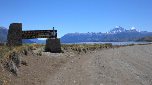
Lanín National Park is located 14 mi (22 km) Southwest of Ilumine,
Neuquén Province in Argentina. This natural reserve of Lanín
National Park covers an area of 379,000 hectares. Much of terrain in
Lanín National Park was formed by the glaciers that left twenty four
lakes and numerous lakes left here when the ice retreated. The name
of the park is derived from a highest peak on its territory, mount
Lanin. Its name is derived from a local Native American language and
can be translated as "dead stone".
It is a recognizable
symbol of the Neuquén Province. Mount Lanin is even depicted on a
flag of the region. This beautiful volcano rises to a height of 3776
meters on the border between Argentina and Chile. Peak of Mount
Lanin is covered by snow thought out a year. The best time to get to
the top is between May and September. You can hike and climb to the
top of the mountain through a network of trails in Lanin National
Park or Villarrica. However keep in mind that it requires proper
gear and experience in mountain climbing.
Volcano Lanin is
considered to be a dormant volcano, however it doesn't mean that it
will never erupt again. At the beginning of the 20th century, the
Argentine government, frightened by the earthquake in Valparaiso on
the Chile side of the border, declared that the Lanin volcano woke
up. It turned out to be a false alarm, but thousands of people
living in the Neuquén Province became frightened and left the
province.
Lanin National Park is famous for its many lakes,
in particular Alumine, Huechulafquen and Lacar. Fishing is allowed
here and salmon as well as trout is abundant. For more information
about the park and its regulations you can visit a city of San
Martín de los Andes on the shores of Lake Lacar or Junin de los
Andes. The quickest way to get here is by taking a flight to
Chapelco airport located nearby.
Management
By resolution No. 126/2011 of the National Parks
Administration of May 19, 2011, it was arranged that the national park
be classified for administrative purposes in the category protected
areas of complexity I, for which it is headed by a designated intendant
, on which 6 departments depend (Administration; Works and Maintenance;
National Park Rangers; Conservation and Environmental Education; Public
Use; Human Resources and Training) and 2 divisions (Dispatch and Entry,
Exit, and Notifications Desk; Legal Affairs). Intendency has its
headquarters in the city of San Martín de los Andes.
park
geography
It has an extension of 412,003 ha, which makes it the third
largest national park in Argentina. The area of the Lanín National
Park is subdivided into two management areas: a national park with
216,993 ha, and a protected area with managed resources with 195,010 ha
divided into three reserves called the Lácar Zone, the Ruca Choroi Zone,
and the Malleo Zone. Decree No. 2149/90 of October 10, 1990 designated 6
sectors of the first area as a strict nature reserve.
Part of the
extension of the Lanín National Park is private property, since there
are 7 Mapuche communities within it that occupy 24,000 hectares; 12
non-indigenous population settlements; 12 privately owned ranches
occupying 24,323 hectares; 8 private subdivisions with 1,871 lots that
occupy 26,865 hectares; and around 4000 hectares of the Argentine Army.
It is well known for the conical and snow-capped Lanín volcano and
for the adventure tourism options it offers. Lakes Huechulafquen and
Lácar are the most visited, but there are others such as Paimún,
Curruhué, Meliquina or Lolog. Salmon and trout fishing abound in its
various lakes and rivers. Many of these fish are cultivated in farms in
the area, to avoid the depopulation of the fish fauna. It also has
several jumps and waterfalls, among which the Chachín waterfall, on the
homonymous river, stands out.
The closest cities are Junín de los
Andes and San Martín de los Andes; the latter has a great infrastructure
that includes a winter sports complex on Cerro Chapelco. A little
further away than these two, the town of Aluminé is relatively close to
the park. Another nearby town is Rucachoroi, populated mainly by
Mapuches who make interesting handicrafts (matras, pehuén "walnut"
bread, llao-llao candy, etc.).
Protected species
It is
populated by varied cold forests of the formation called Patagonian
Andean forest and Valdivian forest, mainly with large trees from the
group of conifers and Nothofagaceae, trees many of them not present in
other parts of the Argentine territory and dating back hundreds of
years. You can find coihues, lengas and pehuenes (or araucarias), the
raulí, male maniú and female maniú -unique in the Lake Lácar area-
pellín oak, arrayán, and the cypress of the mountain range, among
others.
The autochthonous and non-native fauna is very similar to
that existing in the Nahuel Huapi National Park, with which it borders
to the south, with the differences of a slightly greater variety of
species of the genus Nothofagus and the presence of the pehuén, which is
totally absent in that park.