Location: 16 mi (25 km) North of Cafayate, Salta Province Map
Area: 650 km²
Info: Ave San Marin
Tel. (03868) 495 005
Open: daily
Official site
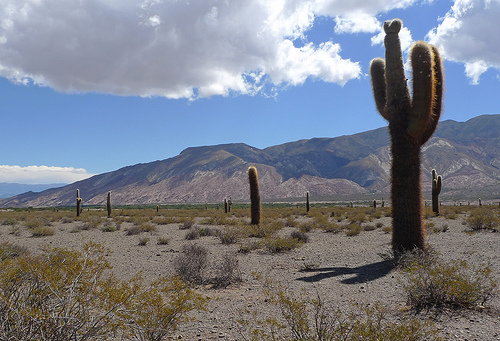
Los Cardones National Park is located 16 mi (25 km) North of Cafayate, Salta Province in Argentina. Los Cardones National Park covers an area of 650 km². Los Cardones National Park is located in the Salta Province of Argentina. It was created on November 20, 1961 and covers a total area of 64 117 hectares of dry sierras. Los Cardones altitude ranges from 2700 to 5000 meters above sea level. The predominant vegetation consists of cardones, a local name give the species of cacti known as Echinopsis atacamensis. It is also the reason why Los Cardones gets its name. In addition to unique landscape and pristine nature Los Cardones is famous among paleontologists as a treasure trove of dinosaur fossils that date to the late Cretaceous period, the end of the Dinosaur age. Additionally national park contains remains of the earliest Native American settlements in the area. Pre- Hispanic settlers inhabited local pastures along scarce sources of water. As you hike through the area you can encounter rock paintings and cave art.
The predominant vegetation is that of the Prepuneña phytogeographic
province, made up mainly of cardones, local name given to the large
cacti of the species Echinopsis atacamensis, although there are also
species characteristic of the Monte de Sierras y Bolsones
phytogeographic district of the Monte phytogeographic province. of the
Puneña phytogeographic province, and of the Altoandino Quechua
phytogeographic district of the Altoandina phytogeographic province.
Important paleontological remains are found in the national park,
such as 70-million-year-old dinosaur footprints. These footprints are
the object of study for scientists. There are also cave paintings.
The area was important to pre-Hispanic cultures, as shepherds found
water and pastures to feed their flocks.
The national park does
not have adequate infrastructure to receive tourists. It is crossed by
Provincial Route No. 33 for 38 km of asphalt, which links the Lerma
Valley with the Calchaquíes Valleys and forms a perfect straight called
the Tin-Tin Straight. The main access is on that route and there are bus
stops in El Churcal and Zapallar. Provincial routes No. 42 (gravel,
towards Seclantás), 48 (on land, towards the Cerro Negro school), 27
(secondary, joins Zapallar with Isonza and with Amblayo) and 26
(footprint, towards the Don Otto mine).
Trails: Ojo de Cóndor,
Secreto del Cardonal, Paths of the Past, Cerro Negro, Cerro de los
Milagros, Campos del Churcal, Piedra-Filo del Pelado, Filo del
Pelado-Valle Encantado, Valle-Rumiarco, Southwest Circuit, Southeast
Circuit, Footprints of Dinosaurs.
The zoning proposed by the Management Plan in 2014 is as follows:
Intensive Public Use Zone: a total of 12 ha, comprising: Valle Encantado
Area (there is a viewpoint and parking area, a picnic area and an
information and refuge point are also planned), Viejo Almacén Herrera
(it is an old rest and grocery post and future visitor center to which a
parador would be added)
Extensive Public Use Area: a total of 1,193
ha, including: Ojo de Cóndor viewpoint-path (has a parking area and a
small path), Secretos del Cardonal viewpoint-path (has a large parking
area and a path semicircular), viewpoint-path Caminos del Pasto, trails
to Cerro Negro, Miracle trail, Campos del Churcal, Piedra-Filo del
Pelado trail, Filo del Pelado-Valle Encantado trail, Valle-Rumiarco
trail, Southwest Circuit, Southeast Circuit, Footprints of dinosaurs
Intangible Zone: high Andean and Puno communities of Cerro Negro and
associated wetlands; southwestern slopes and terraces of Cerro Negro
towards Cuesta del Obispo and the plains of Tonco and Tintín (includes
Cardonal); slopes of Cerro Tintín, drainage of the Tintín River, plains
of Cajoncillos, Duendeyacu and Perrayacu (includes the Churcal);
endorreic basin of Cachipampa and Cajoncillos, sectors of humid puna and
grasslands of mist neighboring Piedra del Molino, Valle Encantado and
Rumiarco, not currently involved in the definition of grazing sectors;
valleys to the north and east of the Filo de la Apacheta, and its
extension to the south; valleys with high grasslands, humid and
sub-humid communities and the mountain range between Isonza and Amblayo;
southern zone of Valle del Tonco and surrounding ravines. It comprises
30,641 ha.
Subzone to Recover Intangibility: 22,067 ha are used for
grazing by 9 population groups.
Special Use Zone: includes APN's own
infrastructure, third-party infrastructure and access roads: Antena
Cerro Negro, Antena Telecom, Mina Güemes, Mina Los Berthos, Churcal
Sectional, Piedra del Molino Sectional (Type I area, 60 ha) and the
permanent residence points of the settlers (Type II area, 21 ha).
Transition Zone to National Reserve: includes the spaces occupied by 14
population centers for sustainable activities that will later be
recategorized as a national reserve, which will allow the permanent
presence of residents and their subsistence activities. It comprises
10,902 ha.
On November 21, 2017, an addendum was approved that fixes
the immediate zoning while the long-term proposal is carried out, which
established substantial modifications in the zoning:
National
Park: 31,135 ha of intangible area, 32 ha of special use, 4 of intensive
public use and 322 of extensive public use (total of 31,493 ha).
National Reserve: 20 ha of intangible area, 27 ha of special use, 7 of
intensive public use, 813 of extensive public use and 32,249 ha of
resource use area (total of 33,176 ha).
Most of the area has a clearly arid climate: dry and hot with average
temperatures of 11 °C in winter (with minimums slightly below 0 °C) and
18 °C in summer (with maximums of 30 °C). Rainfall is scarce, the annual
average does not exceed 200 mm. And this is only in the summer time of
the year (November to March) where more than 90% of the rainfall occurs,
it does not rain the same in all places and it does not rain the same
amount every year. Exceptionally snowfalls occur in the lowest part of
the area (2700 meters above sea level) where the annual temperature
varies between 9º and 10 °C. Already over 3500 meters above sea level in
the eastern mountains precipitation occurs in the form of hail. Towards
the East, where the Enchanted Valley and the lower slopes of the Cuesta
del Obispo are located, a transition from arid to humid climate is
observed.
Topography
There are three types of environments:
the sierra, with pronounced relief of all the mountains and isolated
hills; that of foothills and slopes, which has gently sloping surfaces,
preserved from the active action of river supply and surfaces subject to
wear and tear and river sediment supply; and that of the depressions,
which corresponds to the lower parts of the relief where there is a
continuous supply of fine material transported by water.
The
mountain environment is characterized by the presence of soils that
present abundant outcrops of consolidated and unconsolidated rocks,
found in order of dominance: shallow stony soils; medium to fine
textured soils and deep stony soils.
Three types of soils are
found in the foothills and slopes: red desert soils; red desert soils
with discontinuity at a concentration of calcium carbonate and soils
that present an accumulation of fine and/or stony material, contributed
by water on soils of medium to fine texture.
Flora and fauna
The highest areas present groups of churqui (Prosopis ferox). The
diversity of cactus species is important, among them the small hawthorn
Echinopsis cinnabarina
The fauna includes some rare or threatened
species, such as the pajonal cat (Leopardus garleppi) or the red
(Lycalopex culpaeus) and gray (Lycalopex gymnocercus) foxes. Guanacos
(Lama guanicoe), Lagidium viscacia chinchillones and Chaetophractus
vellerosus piches or armadillos are frequent.
The park presents a
great variety of birds and was defined as one of the important areas for
the conservation of birds in Argentina.
Considering only one
family of the order of songbirds, the presence of specimens of
red-tailed walker (Geositta rufipennis) has been recorded;
Straight-billed Bandurritas (Ochetorhynchus ruficaudus), Chestnut-tailed
Bandurritas (Ochetorhynchus andaecola) and Andean Bandurritas
(Upucerthia validirostris); common (Cinclodes fuscus) and Andean
(Cinclodes albiventris) pinwheels; cinnamon pike (Leptasthenura
fuligiceps); Andean canasteros (Asthenes heterura) and pale (Asthenes
modesta), the Andean espinero (Phacellodomus striaticeps) and the brown
sperm whale (Pseudoseisura gutturalis).
Management
By
resolution No. 126/2011 of the National Parks Administration of May 19,
2011, it was established that the national park would be classified for
administrative purposes in the category protected areas of complexity
III, for which it is headed by a designated intendant, on which 4
departments depend (Administration; Works and Maintenance; National Park
Rangers; Conservation and Public Use) and the Dispatch and Entry, Exit,
and Notifications Desk division. The administration has its headquarters
in the town of Payogasta and exists within the national park the El
Churcal and Piedra del Molino sections.