Location: 159 mi (256 km) West of Puerto Peseado Map
Open: 8am- 6pm daily
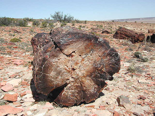
Monumento Natural Bosques Petrificados de Jaramillo is a natural park that protects fossils of the ancient petrified forest located 159 mi (256 km) West of Puerto Peseado in Argentina. Monumento Natural Bosques Petrificados de Jaramillo or Petrified Forest Natural Monument in the North- East Santa Cruz Province of Argentina is a natural formation of fossilized ancient forest. It cover a total area of 13,70 hectares (34,000 acres). Semi desert area is littered with remnants of the ancient forest dating back 150 million years ago during the late Jurassic period of the Mesozoic Era when the area was frequented by massive dinosaurs. Much of the area at the time was covered by evergreen conifer trees of now extinct Araucaria mirabilis. Volcanic activity of the Andes mountains covered ancient forest with ash and lava. This offered a great chance for petrifications of ancient trees and its cones in a perfect time capsule. Some of the fossils discovered in the area were measured at 100 m (328 feet) in height with a diameter of 3.5 m (11 feet). Apparently Patagonia and area of Monumento Natural Bosques Petrificados de Jaramillo during the Jurassic peiod enjoyed much wetter and warmer climate than today.
It is located in the Deseado department, with the
closest towns being Jaramillo and Fitz Roy, 140 km north of the
paleontological site. Until 2012, legal protection only covered the
15,000 ha extension of the Petrified Forests natural monument,
approximately at coordinates 47°40'00″S 68°10'00″W. The National Parks
Administration acquired the adjoining areas that completely surround the
natural monument, thus increasing the protected area.
The
Petrified Forests of Jaramillo National Park almost entirely surrounds
the area of the Petrified Forests natural monument, which in practice
is the core zone of the combined protected area. Adding both surfaces,
the protection reaches 78,543 ha.
It belongs to the Patagonian
steppe ecoregion, whose climate is cold and dry with winter rainfall of
less than 400 mm, with strong westerly winds, dry summers, and frost for
most of the year.
The administration of the Petrified Forests
natural monument and the Petrified Forests of Jaramillo National Park is
located in the city of Caleta Olivia.
History
150 million
years ago, in the Upper Middle Jurassic period, the area occupied by
this national park had a stable climate with abundant humidity. Dense
forests with gigantic trees developed, among which ancient relatives of
the pehuenes (araucaria) deserve to be highlighted. At the beginning of
the Cretaceous period, volcanic eruptions, which coincided with the
beginning of the rise of the Andes mountain range, buried vast
extensions of the Patagonian territory with ash and lava. Part of the
forests covered by ashes were subjected to petrification processes.
The emergence of the Andes mountain range produced drastic
transformations in the environment, by changing the climate of all of
Patagonia. Since then, the humidity transported by the winds of the
Pacific Ocean condenses when crossing the heights and causes rains that
allow the development of the current Andean Patagonian forests. The
strong winds continue their way to the east, drying out the steppe even
more. Subsequently, the erosion of a territory that became increasingly
arid exposed large sectors of these forests that became petrified over
the course of millions of years, even leaving some specimens standing.
Low altitude elevations crowned by lava, represent the vestiges of
the volcanic activity of that time. A good example of this is the Madre
e Hija hill, an extinct volcano that stands out as a prominent figure in
the landscape that can be seen from the paleontological site.
Prehistory
More than 10 millennia ago, the area was the seat of
hunter-gatherer populations, whose testimonies are the diverse and
numerous types of settlements found: "picaderos" or workshops, base
camps, burial sites and quarries for the extraction of raw materials.
Among the latter , the fossil wood of araucarias from this park was
selected for the manufacture of stone instruments.
For the
economy of these human groups, the diversity of the area's
microenvironments -such as meadows, shallow temporary lagoons, canyons,
high plateaus, grasslands- offered a set of resources available in
accessible spaces with short trips: water throughout the year in the
springs (small oases), shelter and firewood, good visibility, animals
for hunting such as the guanaco and the shorty rhea or rhea, and a great
availability of rocks for carving artifacts.
Access
Access to the area is on National Route 3,
between the towns of Jaramillo, to the north, and Puerto San Julián, to
the south. At km 2074 of this RN 3, Provincial Route 49 begins, which
after a 50 km journey reaches the Park Ranger Section of the national
park, where the Visitors' Room and the Paleontological Path are located
on foot. .
tours and services
The supply of drinking water,
food, and fuel for visitors is made difficult by the distance to the
closest towns, 140 km away —Jaramillo and Fitz Roy—, and 90 km from the
south —the Tres Cerros area— , all on gravel roads.
Camping is
not allowed in the park, you can spend the night in the private campsite
20 km from the place, on the access road. The pedestrian trail runs 2
km, where you can see large specimens of petrified araucarias. In
addition, the circuit offers the possibility of making a short route of
easy traffic for all public. It is free to access.
The place
remains open throughout the year.