Location: 135 mi (216 km) Southwest of La Rioja, La Rioja Province Map
Tel. (03825) 470 356
Area: 2,150 km²
Open: May- Sep 8:30am- 5:30pm daily
Oct- Apr 8am- 6pm daily
Official site
Talampaya National Park is situated 135 mi (216 km) Southwest of La
Rioja, La Rioja Province in Argentina. Talampaya National Park
covers an area of 2,150 km². In 2000 it was added to UNESCO World
Heritage Site. Talampaya National Park was created to protect
biosphere of the region as well as archaeological and
paleontological sites that dot the area. Numerous rocks in this area
are covered by the depictions of people, animals and abstract
shapes. One of the most visited historic sites in Talampaya National
Park in so called the Lost City. It is a group of natural boulders
with ancient petroglyphs of native tribes. Additionally several
ruins of ancient dwellings and human burials indicate that this
region was a permanent settlement.
But this is not the only
interesting find in the region. Palaeontologists discovered remains
of ancient turtles and dinosaurs in the dry riverbed of Talampaya.
Some of the fossils date back to 210 million years ago when
dinosaurs roamed the Earth. Administration of Talampaya National
Park restricted access to ancient settlement so the only way to get
there is by taking a local guide. Take plenty of water and something
to protect your skin. Sun can be quiet unforgiving here. Local
souvenirs shops sell souvenirs and pictures of the ancient rock art.
Local botanical garden of Talampaya National Park offers
tourists a chance to see some of the most unique representative of
fauna in the region. Additionaly the entrance to the protected
bioreserve is notable for tourist information center. Here you can
get information how to "The Lost City" and the bed of the river
Talampay. Numerous shops offer souvenirs with images of petroglyphs
and rock paintings.
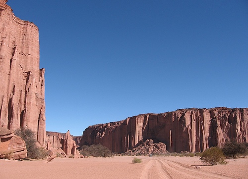
The low mountains of western Rioja expose erosion
processes that form straight canyons and high walls. Its landscape,
flora and fauna are characteristic of the mountain biome. It is the
result of tectonic movements, to which water and wind erosion have been
added for millennia in a desert climate with large thermal amplitudes,
intense heat during the day and low temperatures at night, with
torrential rains in summer and strong winds in spring. The average
height of the land is around 1300 meters above sea level.
Climate
The climate is continental and almost extreme temperatures prevail in
both summer and winter. Sensitive temperature variations are frequent
during the day, and with respect to the night the differences are
notorious. Summers are hot, with maximums that can exceed 50°C in the
sun, and winters with absolute minimums of -7°C to -9°C. The months with
probability of frosts go from May to October. Solar radiation is
intense. The winds blow throughout the year and the most frequent are
those from the northwest, west, and southeast quadrants, with the Zonda
wind being one of the most violent. Low humidity is characteristic in
both summer and winter, except when torrential rains occur, often
accompanied by hail. These are temporary and most often occur in the
summer. In winter there is usually some isolated snowfall. The average
annual rainfall in the region is 150 to 170 mm.
Flora
It is
found mainly in the bushy vegetation typical of desert areas such as
sparse, wild cane, stunted and broom, which practically have no leaves
and photosynthesis is carried out in their green stems. The jarillas
with shiny and resinous foliage, and the tar, covered with yellow
flowers in spring. There are also some cacti such as the puquis and
various cardons, as well as the chilca, a bush from the mountain slopes
that is endemic to La Rioja, San Juan and San Luis. On the other hand,
open forests of large carob trees unfold in the temporary riverbeds, in
Los Cajones, drinking molles.
Fauna
120 species have been
documented in the fauna of the national park, of which 16 belong to
insects and 104 to vertebrates, of which the gray fox, the black-legged
chuña, and the black calandria deserve to be highlighted, which are
common in the near the entrance to the area. The high reddish walls are
used as roosts by various birds of prey, such as the Andean condor, the
Moorish eagle, and the peregrine falcon. They are also the home of
rodents such as the chinchillon. Among the bushes of the sandy pockets
it is possible to see some endemic species of Argentina, for example the
sand cock, the reddish canastero, the brown sperm whale. Among the
mammals, the pichiciego, a small armadillo with subterranean habits.
Some guanacos with brown fur, characterized by their necks a little
longer than normal, can also be seen in the national park. Other species
present are Andean suris, quirquinchos, hares, vicuñas, pumas, maras,
red foxes and reptiles such as pythons and rabbit vipers.
Talampaya shares with Ischigualasto the Triassic
geographical basin. All this geological basin is considered one of the
most important paradises in geological material of the Argentine
Republic. The park has rocks that document the evolution of the planet
for more than forty-five million years, for example witnessing the
division of the supercontinent Pangea more than 250 million years ago.
The Talampaya formation is made up of an agglomeration of
brownish-red rocks. The walls and the canyon of the Talampaya River were
eroded by wind and water, giving them curious shapes. Collective
mortars, remains of indigenous dwellings and ancient petroglyphs are
added to the landscape. The strata are mainly formed by sandstone
deposited by alluvial fans that descended from the edges of the basin.
This rock, due to the wind erosion of millions of years, with its
multi-colored sandstones and clays, acquired various forms. Many of
these forms have their own names such as: the Friar, the Magician King,
the Cathedral, the Chess Board, the Needles, the Manger and the Castle.
In the area known as Ciudad Perdida, the splendor of the Talampaya
geoforms can be seen.
In the basin there are five formations
represented by a sedimentary cycle that begins with red bed sediments
(Tarjados formation), which are followed by gray sediments (Ischichuca
formation), then green layers appear (Los Rastros formation); They are
succeeded by gray formations (Ischigualasto) and finally by the reds
beds of the Los Colorados formation.
The park is an important paleontological site, it is a site of great importance due to its abundant wealth of fossils. Among the fossils discovered is the Lagosuchus talampayensis, one of the first archosaurs to inhabit the Earth, 250 million years ago, at the beginning of the Triassic. Fossils of turtles with an age of 210 million years were also found, such as the Palaeocheris talampayens. Thanks to a long series of fossil animals unknown to paleontology, one of the most interesting studies in paleontological science is being completed: how and when the first dinosaurs arose, in addition to increasing knowledge about the mammalian reptiles from whose basic trunk they later arose. the mammals.
In the area, human occupations date back to the year
120 and 1180 AD, where important engravings and paintings discovered on
stones and ceramics were found, expressing a harmonizing fusion between
nature and culture. The most important nucleus where the traces of this
ancestral culture can be observed corresponds to the area called Los
Pizarrones, which is located on the bed of a temporary tributary stream
of the Talampaya River, in a flat and smooth sector of rock about 15 m
long covered of sculpted engravings (petroglyphs) several centuries
before the conquest.
Remains of houses and stone walls, fragments
of baked clay and lithic material from the making of rock elements were
also found in the area. It is to be assumed that in those times, about a
thousand years ago, the climate would have been somewhat more humid and
the greater abundance of permanent waters, vegetation and fauna would
have facilitated the installation of stable human groups and the
occasion for the development of their artistic manifestations, rock art
and crafts.
The vast basins remained virtually unknown due to
their isolation. Only the construction of the highway in the 1970s,
linking Patquía with Villa Unión, allowed the entry of motorized
vehicles. The objective was to preserve an interesting sample of the
mountain environment, archaeological and paleontological sites in a
setting of impressive scenic beauty. The canyon and its access were
built for the first time by the engineer Werner Lorenz, a German
surveyor based in Villa Unión.
Its dissemination as a natural
wonder is due to Federico Kirbus, journalist, writer, researcher, who
from 1977 began publishing illustrated articles on the Talampaya and
Ischigualasto formations, notes that thus began to attract the first
independent tourists.
Access and tourism
The Talampaya canyon
is located 59 km from Villa Unión, 150 km from Patquía and 216 km from
the city of La Rioja.
The Talampaya National Park is crossed by
National Route No. 76, which connects the towns of western Rioja with
the city of Patquía in the same province. The section of Provincial
Route No. 26 between Villa Unión and Los Baldecitos —the latter town on
the border of the provinces of La Rioja and San Juan— crosses the
national park. The reporting center is located 14 km from this route,
deviating to the northeast.
In the place where the information
center is located, which has restrooms and a bar, tours of the Talampaya
canyon begin, where you can see various samples of the archaeological
heritage, particularly in the Puerta de Talampaya and Los Cajones
sectors. The Lost City is one of the most attractive tourist sites, due
to its panoramic beauty and the strange geoforms that can be seen there.
To access this circuit, authorization from the park ranger must be
requested.
Inside the park you can see: the dry bed of the
Talampaya River, where dinosaurs lived millions of years ago; remains of
original peoples, such as the petroglyphs of the Puerta del Cañón; a
botanical garden of native flora reserve; natural walls up to 145 m high
with geological formations carved into the red sandstone; fauna of the
region.