Location: Upper Styria Map
Area: 110 km²
Official site
Gesause National Park is Austria's youngest parks. It was established on 26 Oct, 2002 and covers 110 km2. Gesause National Park lies in the valley of the Enns river in the mountainous region of Ennstal Alps in the Upper Styrian province of Austria. Today it covers 110 square km and was established on October 26, 2002. The highest peak in Gesause National Park is mount Hochtor at 2369 m (7772 ft) and most of the park cover altitudes between 480 m and 2369 meters above sea level. Gesause National Park is largely covered by pine trees, spruce and fir. Mountain peaks are largely trees with alpine fields. The river valley is home to numerous rare animals and plants.
Location, Size, and Boundaries
The park spans approximately
110–123 km² (11,000–12,300 hectares), making it Austria’s third-largest
national park. Coordinates center around 47.59°N, 14.64°E. It was
established in 2002 as the country’s youngest national park and is
divided into a core nature zone (largely untouched) and a conservation
zone. To the north, it borders the Nature Park Eisenwurzen and lies only
about 10 km from Kalkalpen National Park in Upper Austria. The southern
boundary follows the Enns River valley, while the rugged limestone
massifs define the east and west.
Topographic maps clearly show the
park’s elongated shape along the Enns River, with steep mountain ridges
rising sharply from the valley floor.
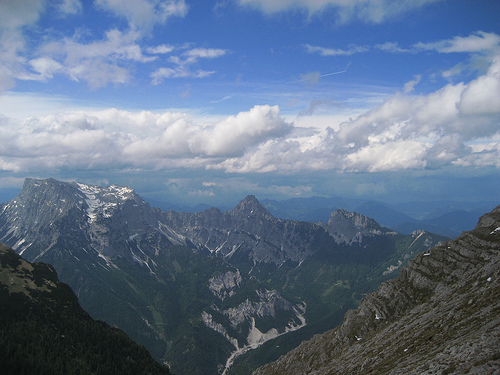
Topography and Relief
Gesäuse is defined by extreme relief energy—one of its most striking
geographical features. Elevation ranges from about 489 m (valley floor
along the Enns) to 2,369 m at the summit of Hochtor, with an average
elevation around 1,222 m. In places, the vertical rise from river to
peak exceeds 1,800 m over a horizontal distance of just a few hundred
meters. This creates a highly dissected, inaccessible landscape of sheer
cliffs, deep gorges, scree slopes, and narrow valleys.
The terrain
compresses multiple altitudinal zones into a compact area: alluvial
river flats, steep forested slopes, dwarf-pine shrublands, alpine
meadows, and barren rock faces. The high relief drives intense
geomorphological processes, including rockfalls, landslides, avalanches,
and rapid erosion.
Major Mountain Groups and Peaks
The park
protects the core of the Gesäuse Range, divided into three main
subgroups of the Ennstal Alps:
Hochtor Group — highest and most
prominent, with Hochtor (2,369 m, prominence 1,523 m) as the park’s
apex.
Buchstein Group — includes Großer Buchstein (2,224 m).
Reichenstein Group (Admonter Reichenstein Group) — peaks like Admonter
Reichenstein (2,251 m).
In total, the park contains 82 named
mountains. The limestone peaks form dramatic, jagged ridges and vertical
walls, often compared visually to Yosemite’s granite landscapes but
composed of sedimentary rock.
Hydrology: Rivers and Gorges
The
Enns River is the park’s hydrological backbone and namesake (“Gesäuse”
derives from the roaring sound of its rapids). It has carved a
spectacular ~16 km-long gorge through the limestone massif, one of the
most impressive water gaps in the Eastern Alps. The river drops over 150
m in this section, creating white-water rapids, gravel banks, islands,
and alluvial forests. Several kilometers remain unregulated—the last
wild stretches of this major Alpine river.
The Johnsbach (a
tributary) adds further wild streams and side valleys. Karst hydrology
dominates: rainwater infiltrates limestone rapidly, forming extensive
cave systems (vertical shafts, sinkholes) and numerous springs (e.g.,
Etzbach spring). This results in both arid rocky surfaces and reliable
water sources for ecosystems.
Geology and Rock Formations
Gesäuse belongs to the Northern Limestone Alps, a 500 km-long, 30–50
km-wide belt of sedimentary rocks. The dominant lithologies are
Dachstein limestone (thick-bedded, fossil-rich from Upper Triassic
lagoons and coral reefs) and Wetterstein dolomite (more brittle). Other
layers include Raibler Schichten (Triassic clay/sand deposits from
sea-level drops) and, at the southern margin, Grauwacke Zone schists
(older Paleozoic basement rocks rich in ores).
These rocks originated
as marine sediments in the ancient Tethys Ocean (Triassic–Jurassic,
~250–145 million years ago). Tectonic compression from the African
plate’s northward push (Cretaceous–Tertiary) thrust and folded these
layers, uplifting the Alps and stacking limestone sheets over the
Grauwacke basement. The result is the classic “High Limestone Alps”
landscape of the Hochtor, Buchstein, and Reichenstein groups.
Geomorphological Processes and History
Tectonic uplift continues
slowly today.
Fluvial erosion by the Enns has incised the deep gorge
over millions of years.
Glaciation (Pleistocene Ice Ages, especially
the last ~120,000–12,000 years ago) played a major role: a large Enns
glacier dammed at Weng, overflowed passes, and deepened valleys by up to
200 m. Local cirque glaciers left moraines, while post-glacial melt
formed temporary lakes and high moors.
Karst processes create caves
and springs.
Periglacial weathering (frost wedging, ice) and mass
movements produce extensive scree slopes and rubble heaps.
Current processes—river incision, rockfall, frost shattering—keep the
landscape dynamic and “untamed.”
Land Cover, Habitats, and
Landscape Diversity
Land cover reflects the rugged topography:
~52% forest (primarily spruce-dominated, with natural and near-natural
stands, including primeval forest remnants).
~24% rocks/rubble/scree.
~13% mountain pines/dwarf shrubs.
~10% alpine lawns/pastures and
meadows.
Minor water bodies and settlements.
Vegetation zones
transition sharply: alluvial forests and mixed deciduous woods along the
Enns → dense spruce forests on mid-slopes → krummholz (dwarf pine) and
rock-crevice vegetation → colorful alpine meadows and pastures at higher
elevations. The extreme relief creates microhabitats (avalanche chutes,
scree slopes, gravel banks) that support high biodiversity, including
many endemics.
Climate
Gesäuse has a typical inner-Alpine
climate with strong elevational gradients. Valley floors average ~8°C
annually with ~1,300 mm precipitation; summit regions drop to –1°C to
–2°C with up to 2,000 mm (much as snow). The park’s remote location
yields exceptionally dark night skies.
In summary, Gesäuse National
Park’s geography is a masterclass in Alpine dynamism: ancient marine
sediments uplifted into towering limestone peaks, sculpted by ice,
water, and frost into a wild, high-relief gorge landscape where untamed
rivers roar beneath sheer cliffs. This compact yet vertically extreme
terrain compresses an extraordinary range of landforms, habitats, and
processes into one of Europe’s most pristine and visually spectacular
mountain wildernesses.
The habitats of water, forest, alpine pastures and rock are the
defining elements in the Gesäuse National Park. Due to their special
importance, they were incorporated into the national park's logo in
the form of blue, green and gray stripes. The Enns river roars its
way through a gorge at the entrance to the Gesäuse natural monument.
Behind it is fed by the tributaries Johnsbach and Hartelsgraben, as
well as numerous water bodies, some of which are only temporary.
About half of the national park area is covered by forest. Alluvial
forests and maple-ash forests can be found in the valley. Snow
heather pine forests grow as Ice Age relicts in some locations. In
terms of area, spruce-fir-beech forests make up a large proportion,
with many forests having been heavily influenced by forestry in the
past, with spruce dominating them today. Larch joins in at higher
altitudes. As a special feature, the easternmost stands of Swiss
stone pine grow here. Above the tree line, the mountain pine forms a
closed belt of crooked wood. Due to the high relief energy, plants
also migrate down the valley in the debris and avalanche channels,
so that a large number of alpine plants (and animals) can also be
found near the valley in the Gesäuse National Park.
Specially
protected species
Proven species of the Habitats Directive are
Apollo butterflies, common ant blue, Spanish flag, yellow ringed and
scabious fritillaries, longhorned beetle, yellow-bellied toad,
bullhead, Ukrainian brook lamprey, barbabie bat, lesser horseshoe
bat and otter. Among the plants, yellow lady's slipper, green
forktooth moss and green tarsier moss are listed.
Of the 90
breeding bird species, 17 are listed in Appendix I of the Bird
Protection Directive and 24 are endangered throughout Austria.
The Gesäuse National Park is considered a hot spot for endemics. The density of species with a small geographical distribution is particularly high in this part of the Northeastern Limestone Alps. The national park's official website lists 30 endemic plant species, including the dainty (beautiful) feather carnation, the north-eastern alpine poppy or the Austrian bellflower. Among the animal species, 195 endemics are named, including the northern giant eye, a harvestman, and the Styrian creeper, a ground beetle.
Early Human History and Cultural Foundations (Prehistoric to Medieval
Period)
Human presence in the Gesäuse region dates back to the Bronze
Age, with archaeological evidence of metalworking (e.g., a wind-smelting
furnace discovered near Johnsbach). The area’s development was
profoundly shaped by the Benedictine Stift Admont, founded in 1074—the
oldest continuously operating monastery in Styria and home to the
world’s largest monastic library (a Baroque masterpiece).
The
monks of Admont became early explorers of the surrounding Alps. They
managed extensive alpine pastures (Almen), forests, and hunting grounds,
establishing a tradition of sustainable land use that persists in the
park’s cultural landscape today. Admont served as a cultural and
economic hub, with its library and scientific collections reflecting
centuries of scholarly interest in the natural world.
Mountaineering “University of Mountaineering” (18th–Early 20th Century)
By the late 18th century, the Gesäuse’s dramatic peaks (including the
Buchstein and Hochtor groups, with Hochtor at 2,369 m) attracted
naturalists, artists, and climbers. The region earned the nickname
“University of Mountaineering” because local shepherds, hunters, and
later Viennese alpinists pioneered guideless climbing and first ascents.
This mountaineering heritage remains visible today through historic
trails and huts.
Early Conservation Efforts and Threats (Late
19th–Mid-20th Century)
At the end of the 19th century, the Styrian
State Forests were created specifically to prevent land speculation and
over-exploitation. In 1913, the first formal proposals emerged for a
large Styrian nature protection park (initially focused on the Niedere
Tauern), but these were overshadowed by simultaneous plans to harness
the Enns for hydropower. World War I halted progress.
Post-war
hydropower schemes resurfaced. In the 1950s, the utility company Steweag
built the Kummerbrücke reservoir and related infrastructure at
Gstatterboden. In response, in July 1958 the Styrian state government
declared the Gesäuse gorge, adjacent Enns Valley, and Wildalpener
Salzatal as Styria’s first nature reserves—the earliest formal
protection for the area.
Growing Momentum and Conflicts
(1970s–1990s)
In 1975 the Styrian Alpine Association called for a
national park in the Styrian Alps. A 1977 unanimous Landtag (state
parliament) resolution aimed to create a “National Park Niedere Tauern,”
but landowner opposition and conflicting land-use interests stalled it.
Throughout the 1970s and 1980s, new hydropower proposals at the Gesäuse
entrance sparked citizen resistance. In 1986 the “Plattform Gesäuse”
coalition (involving the Nature Conservation Association, Alpine
Association, and Nature Friends) successfully blocked a major power
plant. In 1988 the river gorge entrance was declared a natural monument.
Austria’s broader national-park movement gained traction in the 1990s.
1996 was declared the “Year of National Parks.” In autumn 1996, eight
regional mayors signed a declaration of intent. In June 1997 the Styrian
provincial government passed a foundational resolution for the Gesäuse
National Park. Proponents formed the Verein Nationalpark Gesäuse (1998);
opponents created the Schutzgemeinschaft Nationalpark Gesäuse, fearing
restrictions on forestry, hunting, and alpine farming.
A 1999
feasibility study commissioned by the state and federal government
showed only minimal conflicts between conservation and traditional uses
(tourism, forestry, hunting). Public referendums in 2001 produced mixed
results—Admont voters initially rejected participation, while Weng
strongly supported it—but prolonged dialogue and education shifted
opinion. Even the historically cautious Stift Admont eventually backed
the project, recognizing synergies with its cultural and scientific
mission.
Official Establishment and Early Years (2002–2003)
On
10 July 2001 the state government unanimously approved creation of the
park by October 2002. The Styrian Landtag passed the National Park Act
on 12 March 2002 (effective 1 August). On 26 October 2002 the
federal-state Article 15a agreement was signed, formally establishing
the park. Nationalpark Gesäuse GmbH was founded on 2 December 2002 to
manage operations. The park legally opened on 1 March 2003 with the
national park declaration and management plan. On 5 December 2003 it
received IUCN Category II international recognition.
Post-Establishment Developments and Expansion
The park’s zoning
emphasizes a large “nature zone” (roughly 75–86% of the area) where
natural processes (avalanches, river dynamics, forest succession) are
largely left undisturbed, and a smaller “conservation zone” that
preserves cultural landscapes such as alpine meadows. Since 2003 the
park has conducted extensive applied research (over 300 publications in
the first decade alone) on geology, hydrology, flora, fauna, and
endemism—more than 200 endemic species have been documented.
In 2004
the “Nationalpark Gesäuse Partner” network was launched; today it
includes dozens of local businesses committed to sustainable tourism.
Visitor infrastructure (trails, pavilions, the Au-Erlebnispfad riverside
path, visitor centres in Admont and Weng) balances access with
protection. Challenges include managing adventure sports (kayaking,
canyoning) on the Enns while safeguarding sensitive habitats.
On
26 October 2023 (the park’s 21st anniversary), the federal and state
governments announced a 113-hectare expansion through an agreement with
Austrian Federal Railways (ÖBB), bringing the total area to 12,231
hectares and closing previous “white spots.”
Today Gesäuse National
Park stands as a testament to decades of grassroots activism, scientific
advocacy, political negotiation, and local compromise. It safeguards one
of Austria’s last truly wild Alpine river landscapes while honouring a
rich cultural legacy that stretches from medieval monks to modern
mountaineers and conservationists.
Tourism association Gesaeuse
The three national park communities
cooperate with other communities in the region in the Gesäuse Tourist
Association. As part of the municipal structural reform in Styria, the
tourism association founded in 2006 was also restructured on January 1,
2015 in accordance with the Styrian Tourism Act of 1992 (§ 4 Para. 3).
The communities are (in brackets the local class):
Admont (B)
Altenmarkt near St. Gallen (C)
Ardning (C)
Landl (B)
St. Gallen
(B)
Important Places
The tourist office is based in Admont,
where the information office for visitors is located.
The national
park administration is located in Weng.
The national park pavilion is
located in the middle of the national park in Gstatterboden. In addition
to gastronomy, the building offers a fascinating view of the Hochtor
group. The building made of wood, glass and concrete is decorated in the
colors of the national park.
Near Johnsbach, on the Enns, you will
find the willow cathedral, a willow church complex made of living trees
and tarpaulins, in which you can see e.g. presentations and microscope
observations. Another attraction for nature and environmental education
is the "Walkable Ecological Footprint" in its immediate vicinity.
Theme trails include the "Au-Erlebnispfad" through the Lettmayr Au, the
"Wilde John" from Weidendom to Johnsbach, the Johnsbacher Kupferweg
between the copper show mine in the Radmer and Johnsbach and the Lynx
Trail, which includes the protected areas of the Kalkalpen National Park
and the Gesäuse National Park and Dürrenstein wilderness area.