Location: Carinthia Map
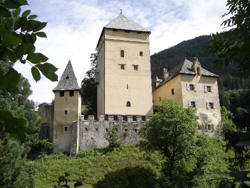
Burg Groppenstein, also known as Groppenstein Castle, is a medieval hilltop fortress located in the municipality of Obervellach in the Spittal an der Drau District of Carinthia, Austria. Perched on a rocky ridge at an elevation that overlooks the Mölltal valley and marks the entrance to the dramatic Groppensteinschlucht (Groppenstein Gorge), where the Mallnitzbach stream meets the Möll River, the castle's strategic position has historically served both defensive and administrative purposes. Its coordinates are 46°56′30″N 13°10′56″E. First documented in 1254 as a tower castle, it evolved into a late medieval fortification and has remained remarkably well-preserved due to continuous habitation and restorations, distinguishing it from many ruined counterparts in the region. Today, under private ownership, it exemplifies Carinthian feudal architecture, blending Romanesque and Gothic elements, and stands as a testament to the area's noble history tied to the Counts of Görz and Habsburg influences. The castle's name derives from the Old High German personal name "Groppo," and it has never been destroyed by fire or war, making it one of the best-maintained medieval structures in Austria.
Origins and Early History (13th Century)
The castle first appears
in historical records on December 23, 1254, as turris Cropensteine
(“Tower of Groppenstein” or “Tower of Cropensteine”). In a charter from
Salzburg Archbishop Philipp von Spanheim, the archbishop enfeoffed his
archer Heinrich Swärhaupt with possessions at Groppenstein; the document
was witnessed by Pabo de Cropensteine, a ministerialis (low-ranking
noble administrator) of the nearby Counts of Ortenburg. This suggests
the tower may have existed slightly earlier as a simple defensive and
residential structure, built to exploit the natural rock defenses.
By
the late 13th or early 14th century, the castle passed into the sphere
of the powerful Counts of Görz (Gorizia, part of the Meinhardiner
dynasty), who ruled much of Carinthia and Tyrol. The local Groppenstein
family served as loyal ministerials—acting as notaries, toll collectors,
court scribes, castellans, and bailiffs. For example, in 1324, Friedrich
von Groppenstein is recorded as court scribe to Count Albrecht of
Görz-Tirol. In 1333, the family received a substantial fiefdom letter as
reward for long service. By 1342, the site was already referred to as a
feste (fortress), though it was still primarily a tower castle
(Turmburg).
The Groppensteiners expanded their influence through land
purchases in the Möll Valley, East Tyrol, and the Puster Valley (as far
as Bruneck) during the 14th and 15th centuries. The original
13th-century core was a mighty five-story Romanesque bergfried (keep),
about 23 meters (75 ft) tall, with a guardroom under the roof and a
wooden walkway for observation and defense.
Expansion into a
Late-Medieval Fortress (14th–15th Centuries)
Between roughly 1470 and
1480, under the Görz ministerials, the castle was significantly upgraded
into a comprehensive late-medieval stronghold. Jakob (or Konrad) Gröppel
von Groppenstein constructed the current Palas (residential palace
wing), along with utility buildings, western towers, and a ring wall
(Ringmauer) with battlements. This transformed the simple tower into an
imposing defensive complex enclosed by crenellated walls. A separate
Gothic chapel dedicated to St. Katharina (with a Romanesque apse) stands
midway along the old ascent path.
The male line of the Groppenstein
family ended around 1486 with the death of Veronika von Groppenstein
(daughter of Conrad III). She had married Wilhelm Graf von Schernperg
(or Schernberg), and the estate passed to her three sons. This marked
the beginning of a series of ownership changes tied to regional noble
families and Habsburg influence.
Ownership Transitions and
Habsburg Ties (16th–18th Centuries)
In 1506, Emperor Maximilian I
formally enfeoffed Christoph Graf von Schernberg with the castle;
Christoph also held the bailiwick of Goldegg in the Salzburg region
under Archbishop Matthäus Lang von Wellenburg. Ownership later shifted
through marriages and sales: around 1588 to Bartholomäus Khevenhüller
and Friedrich von Hollenegg (who had married into the Schernberg line),
then sold in 1612 to Adam Jakob von Lind. Subsequent owners included
Christoph Meyer and Christof Unger.
From 1693 to 1870, the castle
belonged to the Freiherren (Barons) von Sternbach, a family enriched by
Tyrolean copper mines but who gradually sold off much surrounding land
due to financial pressures. During this period, the castle began to show
signs of neglect (e.g., storm damage to roofs by the 1830s), though
continued habitation prevented total ruin.
19th-Century Romantic
Restoration and Modern Era
In 1872, Viennese architect Adolf
Stipperger (a noted preservationist) purchased the decaying property and
undertook a comprehensive “Romanizing” or romantic-historicist
restoration. He rebuilt exteriors and interiors, added neo-Romanesque
features (such as chimneys, crenellated gables, and larger windows), and
created the picturesque appearance seen today. A Knights’ Hall
(Rittersaal) was fitted with a red-marble fireplace and some
16th-century stained-glass windows bearing owners’ coats of arms. The
drawbridge over the western neck ditch was later replaced by a concrete
bridge, and the three-story gatehouse (Torturm) and ring walls were
renewed.
Subsequent owners included Reichsfreiherr von Craigher (from
1884), his daughter Karla Unterrichter, and Viennese physician Prof.
Franz Chvostek (1929–1944), who used it as a holiday home and installed
additional glass paintings. Since 1968, regular restoration work has
continued (including re-roofing the keep). Today the castle remains in
private ownership by Robert Schöbel (and family, including art historian
Judith Schöbel); it is not generally open to the public but can be
viewed from outside and is closely tied to local gorge tourism.
Overall Layout and Structure
The complex is divided into an outer
bailey (Vorburg) and an upper castle (Hochburg/core castle). The main
courtyard (Burghof or Burgwiese) is impressively spacious—over 6,000 m²
of grassy open space—surprising visitors with its scale amid the
fortifications; it serves as a relaxing area and summer open-air stage.
The Hochburg rises about one story higher on the south side, with an
inner courtyard accessible via a wide central staircase. Buildings are
mostly three stories tall, with some basement rooms hewn directly into
the basalt rock for stability and defense. The south façade of the
Hochburg is irregularly notched to follow the natural terrain edge. A
deep well (Burgbrunnen), sunk 120 meters into the rock in the 17th
century, stands in the western part of the Burghof.
Defensive
features include a former moat (Wehrgraben) at the first gate (with
drawbridge remnants visible as recesses and openings), multiple
bastions, a long casemate gallery, and a Zwinger (ward) walkway. The
layout originally supported garrisons and could shelter up to 3,000
people during threats.
Construction Phases and Architectural
Evolution
1157–late 12th century (Origins and Stone Castle): Started
as a wooden fortification and Benedictine monastery founded by Count
Wolfer (possibly with Benedictines as early occupants). King Béla III
confiscated the abbey around 1180 and built a strong stone castle (Novum
Castrum/Újvár) using the monastic stone structures. This phase
established the core defensive hilltop layout, including the Romanesque
base of the later keep. The eastern wall of the old monastery is among
the preserved early ruins.
13th–15th centuries (Medieval Expansions):
Further fortifications under owners like the Pok family (who added a
tower and buildings in the superior castle in the 1250s) and the Ujlaky
family (e.g., major work in 1497). Features from this era include early
palas (representative hall), gates, and the polygonal Rauchfeuerturm
(smoke/fire tower, dated ~1450, used for signaling with chalk fires).
16th–17th centuries (Batthyány Renaissance Fortress): After the family
acquired it in 1524, the castle was massively enlarged as a bulwark
against Ottoman incursions (using Italian engineers). Key period:
1540–1580, with brick reinforcements and artillery adaptations. This
introduced Renaissance bastion systems, round towers, and casemates
suited to cannon fire. The Franciscan monastery (with family tomb) was
founded in 1638 by Adam I Batthyány.
18th–19th centuries and Later:
Strategic importance waned; guns were removed in 1777, and partial
demolition occurred due to high maintenance costs (including Maria
Theresa’s roof tax). In 1870, a Batthyány foundation preserved it as a
historic monument. Extensive restorations in the 20th century
(especially 1980s onward) returned much of it to its early 19th-century
appearance.
Key Architectural Features and Buildings
Towers
and Bastions:
Glockenturm (Bergfried/Keep): The powerful main keep
with a Romanesque base from the early stone castle; largely rebuilt in
1497 under Lorenz Ujlaky. A 17th-century bell story with Renaissance
copper hood and a 1647 baroque bell (by Leonhard Löw) were added; a
clock adorns the exterior. It remains a dominant vertical element.
Scheibelturm: A two-story round turret on a semi-circular plan with a
conical roof, built in 1544 under Franz I Batthyány (renovated 1657). It
housed light cannons with firing slits and guarded the first gate area.
Witwenturm (Widow’s Tower) and Witwentrakt (Widow’s Wing): A massive
three-story bastion-like tower at the south end of a ~50 m single-story
residential block (14th–17th centuries). Ground floor had firing slits;
the flat roof mounted cannons. Adapted in the 16th century for widows,
it now includes a terrace restaurant.
Other towers/bastions:
Ujlakyturm (northern tract remnants), Rauchfeuerturm (polygonal
signaling tower), Scheibelturmbastei, Kanonenbastei (northwest “sharp
corner” bastion), and southern bastions (one with a public garden and
pavilion).
Gates and Entrances:
Franzenstor (Francis Gate):
Named after Franz I Batthyány; round arch with coat of arms and
drawbridge remnants.
Adamstor (Adam Gate): An 18 m rock-hewn tunnel
(medieval core, 15th century) with pointed arches and a baroque brick
portal leading into the Burghof.
Erstes Burgtor (First Gate):
Two-story gatehouse (1672 renovation) with round arch and bastion wall.
Holzgittertor: 17th-century round arch with original wooden drop gate.
Halls and Defensive Structures:
Kanonenhalle (Cannon Hall): Early
17th-century large casemate with firing slits, Renaissance portal, and
vaulting on polygonal columns—designed for heavy cannons and now used
for events.
Casemate Gallery: A 7 m wide, 90 m long vaulted gallery
along the south façade beneath the Hochburg, originally for
ammunition/food storage; now partly a vegetated walkway in the Zwinger.
Palas (Hall Building): 13th-century core on the south side of the inner
courtyard, modified in the 15th century.
Chapel (Burgkapelle
Maria Schnee / Our Lady of the Snow): Mid-15th-century late Gothic
two-story structure (renovated multiple times, including 1642 and 1793).
Interior features a three-aisled layout with polygonal chancel, net rib
vaulting in the choir, ribbed vault in the nave, and a pointed triumphal
arch. The neo-Gothic high altar (1794) includes a painting of the Virgin
and Child; a baroque side altar dates to 1662. It incorporates the
former pilgrimage church from the monastic era.
Bergfried (Keep Tower): The 13th-century centerpiece, 23 meters tall,
with preserved Romanesque elements and a connecting bridge to the palas.
Rittersaal (Knights Hall): In the palas' second floor, featuring a red
marble fireplace from the 1870s and 16th-century stained glass windows;
additional glass paintings were added by Franz Chvostek in the
1930s–1940s.
Burgkapelle hl. Katharina (Castle Chapel of St.
Catherine): A standalone Gothic chapel with a semi-circular Romanesque
apse, consecrated to St. Katharina, located midway on the old ascent
path.
Ringmauer and Torturm: Crenellated walls and gate tower,
restored in the 19th century, enhancing the fortress's romantic
silhouette.
Coats of Arms and Artifacts: 16th-century Schernperg
wappen on the palas; historical stained glass (some lost) depicting
owners.
As of August 22, 2025, Burg Groppenstein is privately owned and not
regularly open to the public for interior tours, though it can be viewed
from the exterior. Visitor reviews on platforms like TripAdvisor rate it
4.0 out of 5 based on limited feedback, describing it as a "romantic
castle" but noting past reconstruction limiting access to outside views.
One recent review (July 2025) praises it as a "beautiful place" with
historical ties, but details like a bird of prey show may refer to
nearby sites, suggesting some confusion in listings. No official opening
hours or admission fees are listed for the castle itself; it appears
inaccessible internally without special permission from the owner.
The castle is reachable via a short hike or drive from Obervellach, near
the Groppensteinschlucht gorge, which is open seasonally (May 17–October
31, 2025) with hours varying from 9 AM–5 PM in peak summer to 10 AM–4 PM
otherwise, and admission of €4–€8. Combine visits with the gorge for
panoramic views of the castle. For updates, contact the Obervellach
municipality or tourism sites like visitmoelltal.at. Respect private
property by staying on public paths; photography from afar is
recommended. Allow less than 1 hour for exterior viewing. Accessibility
may be limited due to the rocky terrain—wear sturdy shoes.
Burg Groppenstein holds profound cultural value as one of Carinthia's best-preserved medieval fortifications, illustrating the region's administrative and defensive history under noble families like the Groppensteiners and Görz counts. Its continuous occupation prevented ruin, preserving authentic elements that offer insights into feudal life, from notarial duties to Habsburg fiefdoms. The 19th-century restoration by Stipperger exemplifies romantic preservation efforts, influencing Austrian heritage practices. As a protected monument (denkmalgeschützt), it contributes to the Mölltal's tourism, drawing history enthusiasts to explore its ties to trade routes and noble lineages. Though privately held, its imposing presence enhances the scenic Groppensteinschlucht, symbolizing Carinthia's layered past amid the Hohe Tauern National Park.