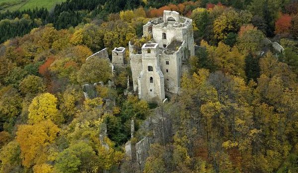
Location: District Oberpullendorf, Burgenland Map
Constructed: 12th century
Burgruine Landsee is a medieval complex of military fortifications neat a small town of Markt Sankt Martin in District Oberpullendorf in Burgenland State of Austria. Although current Germanized name of Burgruine Landsee can be translated as a "Land Sea", it is actually a Hungarian in origin. In Hungarian name can be translated as a "Country here".
Location
The castle ruins are a popular destination in the middle of the Landseer Berge nature park. It lies on a rocky outcrop on a ridge between Heidriegel (there are the remains of a refuge) and the Pauliberg.
Origins in the 12th century
Exact construction date is unknown.
The site first appears in writing in 1158 in the tradition book of
Göttweig Abbey. Graf Ekbert III of Pitten named Gotscalcus de Landeshere
as a witness when he transferred property before a campaign in Italy. In
1173 the Styrian charter book records Erchenger von Landesehre, whose
family also held Hohenwang near Langenwang. An Erchengerus de Landesere
appears again as a witness in 1179. Ottokar of Horneck's rhymed
chronicle later mentions "herr Erkenger von Landeser."
These men were
ministeriales of the Counts of Pitten (then part of Styria) and are
generally treated as a cadet line of the Styrian Stubenberger. The
fortress was planted on the far eastern edge of the Pitten lands as a
border castle: inward against rival Pitten lords, outward against
Hungary. It guarded a road from the Bucklige Welt into western Hungary
and formed part of a chain of strongholds along a contested frontier.
Hungarian period and the Güssing Feud
By 1222 the castle already
belonged to Hungary. A grant of that year names Count Nikolaus, son of
Barcz, as the first known Hungarian lord. In 1263 King Béla IV's former
cup-bearer Conrad had sided with Ottokar II of Bohemia, so the king
granted the county of Lutzmannsburg and Landsee to Lorenz (Laurentius)
of the Aba family, royal steward and comes of Ödenburg (Sopron). The Aba
of Athinai held it for more than a century and were allied with the
Mattersdorf-Forchtenstein lords.
In 1289 Duke Albert of Austria
(later King Albert I) took the castle during the Güssing Feud against
the Counts of Güssing, whose followers included the Aba of Landsee. It
later returned to Hungarian control and remained the western outpost of
the former county of Lutzmannsburg.
15th century: pledges,
Habsburgs, and Matthias Corvinus
Ownership turned over rapidly. In
1425 the Garai (Gara) held the lordship. A document of that year lists
villages belonging to it: Landsee, Draßmarkt, the two Pullendorfs,
Raiding, Neutal, St. Martin, Ober- and Unterfrauenhaid, Neckenmarkt,
Horitschon, Ritzing, and others now vanished. Wilhelm of
Mattersdorf-Forchtenstein pledged Landsee, Kobersdorf, and Forchtenstein
to Duke Albrecht VI of Austria in 1445. The duke bought it in 1447 and
passed it to his brother, later Emperor Frederick III. In 1459 it fell
to King Matthias Corvinus of Hungary. Ulrich von Grafenegg received it
as a grant (already appearing as holder by 1475) and carried out the
late-Gothic expansion of the inner castle; his arms still appear on the
masonry.
The Landseer Fehde and Gertrud von Weißpriach
By 1506
Ulrich von Weißpriach, lord of Kobersdorf, was pledge-holder. After his
death his widow Gertrud refused to surrender the castle when King
Wladislaw II treated it as a lapsed fief. The resulting Landseer Fehde
lasted from about 1508 to 1524 and wrecked the surrounding countryside.
Gertrud hired mercenary bands, including the robber captain Franz
Magusch. They raided merchant traffic between Landsee and Sopron, drove
off hundreds of cattle (one raid on Agendorf took about 200 head),
burned villages, and turned the fortress into a feared robber nest said
to house more than 200 people. Sopron begged the king for help. Captain
Georg Trenka of Sopron moved against her; she was later imprisoned for a
time but the raids continued. Franz Magusch was captured and confessed.
The feud ended under Ferdinand I when the Weißpriach family was
re-enfeoffed. Gertrud is usually said to have died in custody around
1523.
Her son Hans (Johann) later held high office in western
Hungary. In 1548 he transferred Landsee to his brother-in-law Erasmus
von Teufel, imperial councillor, comes of Sopron, and commander of light
cavalry in Hungary. In 1552 Erasmus, on an imperial mission in
Transylvania, was captured by the Ottomans and executed by Janissaries
(another account says he was sewn in a sack and thrown into the Black
Sea). The estate then passed through Nikolaus Oláh, Archbishop of
Esztergom, and the Dersffy family.
Esterházy ownership and last
great building phase
In 1612 Nikolaus Esterházy married the young
widow Ursula Dersffy (previously married to Franz Mágócsy). Landsee has
belonged to the Esterházy family ever since. Nikolaus concentrated on
Schloss Lackenbach and Burg Forchtenstein. Landsee served as a planned
fallback in 1619 when he defeated Gábor Bethlen's troops near
Lackenbach, but it was not needed in the field.
His son Paul
Esterházy (later Palatine and first princely Esterházy) rebuilt and
modernized the fortress from 1666. The outer gate bears the date 1668.
The castle received its final form: seven towers, four defensive rings,
two ditches with wooden bridges, and an outer wall about 1,700 m long
with ten half-towers. During the Turkish wars it was a civilian refuge
and an arms depot for Esterházy troops, though it saw no major siege
because Ottoman armies marched farther north toward Vienna. Living
quarters were already shifting to the more comfortable Renaissance
Schloss Lackenbach.
Fires, decline, and abandonment
On 12 July
1707, between 10 and 11 in the morning, fire broke out on the Kobersdorf
(northeast) side, where the princely apartments stood. An official
inquiry under Palatine Paul Esterházy heard 55 witnesses. There was no
powder explosion and no mass death of a garrison; one carpenter died.
The castle was repaired and remained usable for decades. A supposed
great fire of 1772 is not supported by Esterházy archive material; by
1781 the buildings were still in tolerable condition, though some unused
rooms were already proposed for demolition.
The decisive fire came on
2 June 1790. Prince Nikolaus I Esterházy ("the Magnificent") died in
Vienna on 28 September 1790, leaving his successor Prince Anton about
3.8 million guilders of debt. The castle had lost both military purpose
(the Habsburg lands were united, artillery had changed) and economic
centrality (administration sat at Lackenbach). Reconstruction was not
attempted. In 1802 the complex was described as ruinous and slated to
decay. Local farmers used the walls as a quarry.
Modern ruin
The site has been secured and opened to the public since 1968. A local
association and the Esterházy domain work to slow further collapse. The
last major conservation of the inner castle was an EU project in 1998.
Summer concerts and theatre take place in the outer courtyard. The
donjon walls reach up to 10 m thick; the strongest masonry faces west,
toward the old Austrian side. A modern stair leads to the former roof
level of the keep, with views toward Sopron, the south end of Lake
Neusiedl, and the Bucklige Welt. The first chapel (St. Ursula) stood in
a tower built 1460-1485; a later Baroque chapel was dedicated to St.
Nicholas. A castle cemetery by the approach road held the village's
first parish church of St. Nicholas, already called "very old" in 1647.
Site and defensive logic
The rock itself dictated the plan. Steep
drops to the north and east provided natural protection, so living
quarters and later Baroque residential wings faced that safer side.
The west side, the direction of historical threat from the Holy
Roman Empire, received the heaviest artificial defenses. This
orientation is similar to nearby Forchtenstein Castle.
The result
is a concentric Ringburg of four successive fortification rings. Two
dry ditches (Gräben) separate the outer rings. The outermost wall,
about 1,700 m long and only ~70 cm thick, is the youngest. It was
built in 1668 under the Esterházys and is reinforced by ten small
semicircular or wedge-shaped half-towers (Halbtürme) for flanking
fire. This ring is poorly preserved, especially on the north.
Inner walls are thicker (0.8-3 m in most places, far more at the
keep). Construction used local quarry stone and brick with lime
mortar. Later phases mixed rubble masonry with brick repairs.
Embrasures, keyhole loops, battlements, and machicolations appear at
successive levels.
Approach and gates
Visitors still
follow the original layered approach:
First gate (dated 1668) -
simple, protected by a two-story bastion with guardroom.
Wooden
bridge over the first, very wide ditch (up to 30-40 m). Second gate
is strongly fortified, with a broad machicolis (Gusserker) and
originally a drawbridge. The gatehouse projects into the ditch so
defenders could fire along the next earthwork.
Second ditch
(15-20 m) and third gate, once equipped with a counterpoise
(lifting) bridge and decorated with the Weisspriach coat of arms. A
tower and guardroom flank it.
Large outer courtyard (Vorburg /
outer bailey). Farm buildings, barracks, stables, arsenal, prison,
and a huge granary (Traidkasten, ~1660s) once lined the walls. Only
fragments and the so-called Glockenturm (bell tower, mixed
stone-and-brick, once five stories with dome and lantern) survive.
The courtyard walls themselves have three stories of keyhole loops.
A deep well (traditionally 88 m, 6 m diameter) stood here.
Stair
tower up ~10 m to the inner bailey.
Renaissance gate (replacing
an earlier Gothic round tower) into the upper residential court. A
fifth (now collapsed) gate and sixth gate lead onward to the core.
An earth wall with palisade, built around 1600, sat between the
second and third rings to absorb artillery fire before it reached
the main masonry.
The high castle and donjon
The core is
the high castle (Hochburg), rebuilt in late Gothic style under
Ulrich von Grafeneck (c. 1470-1485). Its heart is the massive
residential tower or donjon on the highest point of the rock.
The
donjon began as a Romanesque pentagonal or wedge-shaped tower. Later
owners repeatedly encased its exposed western face until the shield
wall reached 10 m thickness. The tower itself is about 20 m wide and
20 m high. Ground-level spaces served as storage and prison, reached
by internal stairs. Upper floors held living rooms, kitchens, and
fireplaces. A surviving free-standing masonry arch (Schwibbogen) on
the former roof platform is the remnant of a cupola or vault. A
modern staircase now lets visitors reach this platform for views
toward Sopron, the southern Neusiedler See, and the Bucklige Welt.
Several towers attach to the donjon. One, built 1460-1485, contained
the first castle chapel, dedicated to St. Ursula. Gothic door and
window frames, fireplace remnants, and vaults survive in the inner
rooms. A later Baroque chapel (also St. Nicholas) was added during
the 1650-1679 Esterházy expansions.
The "Neues Schloss" (New
Palace) occupied the representative western/upper part of the inner
court. Its great hall had rich stucco, window niches, and Esterházy
ancestral portraits. Pietro Antonio Conti worked on interiors in the
17th century. These residential wings have largely collapsed to
foundation level.
Construction phases
12th-13th century:
earliest keep and basic high-castle core (ministerials of the Counts
of Pitten).
Late 15th century (Grafeneck): late-Gothic expansion
of the Hochburg, chapel tower, coats of arms.
Around 1600
(Dersffy): conversion of an older tower into the massive donjon,
earthworks against artillery.
1650-1679 / 1666-1668 (Esterházy,
especially Paul): outer ring, bastions, New Palace, Baroque chapel,
granary, further thickening of walls. The castle served as refuge
and arsenal during the Turkish wars but saw no major siege after
1289.
18th century: fires in 1707 (northeast wing, possible
powder explosion) and 1772/1790. After the last fire and the death
of Nikolaus I Esterházy, the site was abandoned. It became a quarry
and was already described as ruinous by 1802.
Stabilization
work began in the 1950s. Major securing of the high castle occurred
in 1998 with EU support. The ruins have been publicly accessible
since 1968. Multilingual signs explain former functions. Summer
events (concerts, theater) use the outer courtyard.