Location: Babruysk Map
Constructed: 1810- 1836
Babruysk Fortress is a historic citadel situated in a Belarus city of Babruysk. Most of the historic castle was demolished and today lies in ruins. First Babruysk Fortress dates back to the Middle Ages. Original castle existed on the right bank of the Berezina River since the 14th century. As the military warfare changed so did military fortifications. Babruysk Fortress had to improve and much of the old structure was demolished to make way for a new fortress.
Planning and Construction (1810–1836)
In March 1810, Russian
War Minister Mikhail Barclay de Tolly proposed new fortifications to
defend the western frontier (a roughly 1,200-verst gap between Riga
and Kyiv). Engineer-lieutenant Teodor (Theodor) Narbut/Narbutt
surveyed sites and recommended the Berezina River bank near Babruysk
over alternatives like Rogachev. Chief Engineer Count Karl (Carl)
Opperman (Oppermann) endorsed the choice; Tsar Alexander I approved
the plan around June 16–20, 1810 (dates vary slightly by calendar).
Construction officially began June 4, 1810.
The old town (over
400 years old) was largely demolished to make way for the
fortress—stone/wooden houses, churches, monastery, town hall,
palaces, and remnants of a medieval fortress were cleared (only the
Jesuit church foundation was reused as a powder magazine/Zeughaus).
Residents were relocated to free suburbs (forstadt). Initial
builders included Major General E.P. Felkerzam (construction lead)
and Major General Gavriil Alexandrovich Ignatiev (troop commander).
Thousands of soldiers and serf peasants from Mogilev, Minsk, and
Chernigov governorates labored, sourcing materials (stone, timber,
etc.) from distant regions like Ukraine, Karelia, the Caucasus, and
the Urals.
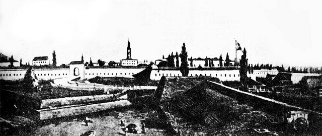
First phase (1810–1812): Partial completion by the
1812 war outbreak. The main defensive line featured 8 bastions, soil
ramparts (up to ~10 m high), water-filled ditches fed by the rivers,
forward forts, a planned bridgehead (tête-de-pont) on the left bank,
and underground escape tunnels extending into surrounding forests.
By 1811, it was classified as a first-class fortress with ~300+
guns, year-round ammunition, and 6-month food supplies. Area: ~120
hectares.
Second phase (post-1812 to 1836/1855): Major expansion
after the Napoleonic Wars, adding bastions/towers (totaling around
18 in some accounts), residential/administrative buildings in
Classicism style, cobbled streets, a botanical garden, Alexander
Nevsky Cathedral, an esplanade for parades/fairs, and Fort Friedrich
Wilhelm (designed 1822 by architect A. Staubert, completed 1825;
visited by Alexander I and his brother). The layout evolved from
symmetrical to more adapted terrain. Full completion ~1836; Nicholas
I praised it as one of Europe's finest.
In the early 1840s, it
was considered the most inaccessible fortress in the Russian Empire
and among Europe's best-equipped.
Key architectural features:
Bastion system with reduits, towers, earthworks, moats/channels,
barracks, and self-sustaining infrastructure supporting a military
community.
Role in the Patriotic War of 1812
The fortress
was partially operational at the invasion's start. Garrison: ~4,000
men, 344 guns. It served as a critical logistics and rallying point
on the southern flank. Bagration's 2nd Western Army rested there
June 6–8, 1812, resupplying, receiving ~1,500 reinforcements, and
evacuating sick/wounded—enabling their timely junction with Barclay
de Tolly's 1st Army near Smolensk.
From July to November 1812, it
withstood a blockade/siege by General Jan Henryk Dąbrowski's
~12,000-strong Polish corps (part of Napoleon's forces) after the
French took Minsk. Under Ignatiev's effective command (nominal
commandant Karl Berg), it faced mostly skirmishes rather than full
assaults but held firm, providing intelligence and support to
Russian forces. Historians like A.I. Mikhailovsky-Danilevsky
credited its site selection and defense as "invaluable" to the
campaign's outcome.
Decembrists, Prison Role, and Mid-to-Late
19th Century
In 1820–1823, elements of the 9th Infantry Division
(including future Decembrists such as Sergei Muravyov-Apostol,
Mikhail Bestuzhev-Ryumin, and others) were quartered here. They
devised the unrealized "Bobruisk Plan" (May 1823) to arrest
Alexander I during a troop review/inspection. After the 1825
Decembrist Revolt, it became a state political prison holding
figures like Vasily Divov, Boris Bodisko, and Vasily Norov. A
notorious egg-shaped solitary confinement cell (preventing
sitting/standing/lying comfortably) was infamous; Alexander Herzen
described it as worse than Siberian exile.
During the 1830–1831
Polish November Uprising, it was fully armed (146+ guns), served as
a Russian troop base, and imprisoned insurgents. It was downgraded
to second-class in 1868, converted to a fortress-depot/warehouse in
1886, and lost military significance by 1897–1900, becoming
primarily a jail. In 1892, the 1st Brigade of the 40th Infantry
Division was stationed there.
20th Century
1918–1920:
Captured by the Polish I Corps (under Józef Dowbor-Muśnicki) in
February 1918 during the Battle of Bobruysk. Used during the
Polish-Soviet War as a POW camp.
WWII (Great Patriotic War):
Briefly recaptured by a Red Army assault group (June 28–30, 1941),
who inflicted casualties and destroyed equipment. Under German
occupation, it became Stalag 131, a major concentration camp for
Soviet POWs and civilians. Peak population exceeded 30,000; ~40,000
POWs and ~40,000 civilians died from executions, starvation,
disease, exposure, and mass killings (e.g., barracks burned with
~7,000 inside on Nov. 7, 1941). Bodies were dumped in ditches near
the Berezina railway stop. It features in accounts like Ales
Adamovich's "Punishers."
Current Status and Preservation
Less than half the bastions and ~50 structures (towers, reduits,
barracks) survive, many badly damaged or ruined. Registered as a
national historical-cultural monument in 2002 (Belarus State List
code 512Г000059). It is open to excursions, film shoots, and
archaeological work. Restoration plans include the sight bridge,
Minsk Gate, and developing a historical-cultural complex with
museums, tours, souvenirs, and a café. Adjacent modern sites include
Bobruisk Arena (2008). It is sometimes called the "elder sister" of
Brest Fortress due to its earlier construction and similar
significance.
Construction History and Key Figures
Tsar Alexander I ordered
construction on June 4, 1810, as part of a network of western border
citadels (including later ones like Brest Fortress). Belarusian military
engineer Teodor Narbutt selected the site and prepared an initial plan,
leveraging the location's strategic river confluence and an existing
14th–17th-century castle site plus the 18th-century Babruysk Jesuit
monastery/house (whose walls and structures formed the initial core).
Narbutt resigned for health reasons; General Major Gabriel Ignatiev took
command. Chief of Military Engineers Count Carl (Karl) Opperman
(Operman) approved the site, drafted the master general plan (approved
by the Tsar on June 20, 1810), and supervised overall works from
1810–1812. Thousands of soldiers and serf peasants built it using
advanced contemporary techniques. The initial phase was partially
complete by 1812. Post-Napoleonic Wars, major expansion occurred around
1820–1825 with additional bastions/towers; architect A. Staubert
designed the Fort Friedrich Wilhelm (added 1822). Alexander I and his
brother inspected it in 1825. Full completion extended to ~1836.
Overall Layout, Scale, and Design Principles
The fortress followed a
polygonal bastion trace (typical Vauban-influenced star/polygonal fort
design adapted for 19th-century artillery), optimized for flanking fire,
enfilade, and defense in depth. It occupied approximately 120 hectares
(a large area functioning as a self-sufficient military town/citadel).
The layout integrated the Jesuit monastery core and older Polish-era
elements. It featured a central enclosed area surrounded by an outer
defensive perimeter of earthen ramparts and water-filled ditches. An
esplanade (open ground) in front allowed for military parades, fairs,
and clear fields of fire. Internally, it included cobbled streets,
residential quarters for garrison families, administrative buildings,
barracks, a botanical garden, a square, and the Aleksandr Nevsky
Cathedral—blending military utility with Classicist aesthetic elements
in non-defensive structures. The design emphasized impregnability
through height, water barriers, and artillery placement; it was
considered one of Europe's best-equipped fortresses in the early 1840s,
with capacity for over 300 guns of various calibers, a year's ammunition
supply, and six months' food reserves. It could house thousands of
troops (e.g., ~5,000 in 1837).
Defensive Architecture and
Fortifications
Earthen ramparts (earthworks/val): The primary defense
consisted of high (up to 10 meters) earthen ramparts/glacis, often
grass-covered for stability and camouflage, with soil ridges providing
additional layered barriers. These were designed for resistance to
artillery bombardment.
Moats/ditches: Wide, water-filled moats
(canals/channels) fed directly from the Babruyka and Berezina rivers
created a "wet" ditch system, enhancing defense against infantry/assault
and complicating siege approaches. Natural rivers served as additional
barriers and supply routes.
Bastions: Initially 5 bastions in the
early phase (projecting angular structures for crossfire along the
perimeter). Expanded post-1812 (~1820) by 18 more bastions and towers,
for a reported total approaching 23 (though sources vary on exact
surviving counts; fewer than half of original bastions remain intact).
Bastions enabled mutual support and artillery placement.
Additional
elements: Reduits (small internal forts/blockhouses), towers, soil
ridges, water channels, and likely scarps/counterscarps (revetted
slopes, probably brick/stone-faced in sections for durability, though
primarily earthen). Specific additions included the Fort Friedrich
Wilhelm (a dedicated outwork/fort designed by A. Staubert in 1822,
likely a polygonal or lunette-style structure).
Other features:
Powder magazines, casemates (bomb-proof shelters), gates (e.g., Minsk
Gate), and a drawbridge/sight bridge (restoration planned). The design
incorporated advanced solutions for the era, including provisions for
prolonged sieges.
Materials and Construction Techniques
Construction relied heavily on earthen ramparts (excavated soil piled
and compacted, often with timber framing or revetments), brick/stone for
permanent structures (barracks, cathedral, gates, casemates, revetments
on ditches/scarps), and wood for temporary or internal elements
(bridges, palisades, roofing). The Jesuit monastery's existing
brick/stone walls were reused as foundations/core. Rivers provided water
for moats and construction. Thousands of laborers enabled rapid
earth-moving; the project used the latest Russian military engineering
practices.
Military Role, Significance, and Evolution
It
withstood a notable four-month siege in 1812 by Polish forces under
General Jan Henryk Dąbrowski (Napoleon's allies) after the Russian
army's retreat, serving as a key holdout, supply/base, hospital, and
intelligence post. It later housed Decembrist conspirators (some planned
a "Bobruisk plan" uprising here ~1820–1823) and became a political
prison/jail after 1825. Downgraded to second-class (1868) and then a
warehouse (1886); lost primary military role by ~1900. Used in later
conflicts (Polish-Bolshevik War, WWII as Nazi concentration camp with
~80,000 deaths).
Current State
Much of the complex is in ruins
or heavily damaged (many structures demolished 1950s–1980s for urban
development; WWII damage). Surviving elements include sections of
ramparts, bastions, towers, reduits, barracks, gates, and the cathedral
area. Registered as a historical-cultural heritage site (2002); open for
excursions, filming, and archaeology. Restoration plans exist for
features like the Minsk Gate and drawbridge to develop it as a
museum/cultural complex. It remains a poignant historical landmark
despite its condition.
Historical plans and maps (e.g., Opperman's
1810–1812 design) depict the polygonal layout with bastions and
river-integrated moats; some are viewable in archives or online
reproductions (e.g., via Belarus.by or historical collections).