Location: West Herzegovina Canton Map
Area: 364 km² (141 sq mi)
Blidinje Nature Park is located in West Herzegovina Canton of Bosnia and Herzegovina. It covers a total area of 364 km² (141 sq mi) of Grabovica Valley. Besides Illyrian burial monuments (stećci) and ancient Roman roads you will find a micronation known around here as a Hajdučka Republika Mijata Tomića. Its leader and only resident Vinko Vukoja Lastvić named his own nation after 17th century hajduk (partisan) Mijata Tomića who fought against Ottoman Turkish forces and often hid in the caves in the valley of Blidinje Nature Park.
Blidinje Lake is a geomorphological nature monument after which the
Blidinje Nature Park got its name. Located at the bottom of Dugi polje
between the mountains Čvrsnica and Vran at an altitude of 1184 m above
sea level. The surface of the lake is from 2.5 to 6 km² with a
relatively shallow depth of one meter to a maximum of four meters.
Masna Luka is a special forest reserve in the center of the park
with a characteristic phytocenological forest community, rare and
endemic flora and fauna. Together with Borićevca, it forms the largest
complex of whitebark pine in Munika.
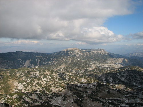
Pločno is the highest peak
of Čvrsnica, at 2228 meters it is the highest peak of the central
Dinarides. Several marked hiking trails lead through the unique
landscape to the top, which is a great attraction for hikers.
Dugo polje is a karst field between the Vrana and Čvrsnica mountains.
Known for its necropolis with 150 stećaks, which received the status of
a National Monument of Bosnia and Herzegovina due to the variety of
shapes and richness of decorations.
Diva Grabovica forms a
grandiose canyon with depths of over 1,500 meters and a length of 6.2
kilometers. Above the canyon is a geomorphological object in the shape
of an arch Hajdučka vrata or Mijatov prolas.
Pilgrimage place on
Kedžara known for the grave of Diva Grabovčeva. Every year in the month
of July, a large number of people, especially girls, make a pilgrimage
to the place where Diva's grave is located.
The ski center is the
winter destination of many visitors. In the center there are several ski
slopes, from those for beginners to those for top skiers, with a
four-seater cable car with a capacity of 1,942 people per hour and a ski
lift. There is a toboggan run for children within the ski centers.
In addition to skiing, the tourist offer of the park consists of:
hiking, mountain climbing, mountain biking, free or organized use of the
nature park area, educational activities aimed at getting to know the
flora, geology, hydrogeology and similar activities.
Blidinje Nature Park is located in the north of Herzegovina in the
area of the high mountains of the Central Dinarides. It covers the area
of the Čvrsnica and Vrana mountain massifs connected by the Dugi polje
valley and the Blidinjski lake. The Dugo Polje fault valley extends in
the NE-SW direction, perpendicular to the Dinaric direction, which
partly determines the direction of the extension of Vran and Čvrsnica,
it is 14 km long and about 3 km wide on average. The park is bounded by
the canyons of Doljanka from the north, Neretva from the east, Drežanka
from the south and the slopes of Vran from the west.
The Čvrsnica
massif consists of the Velika Čvrsnica and Vilinac mountain ridges and
the Velika Čvrsnica, Muarnica, Plasa and Mala Čvrsnica plateaus. In
addition to the highest peak of Plocno, there are five more peaks over
2000 m; Draga kosa 2217 m, Jelinak 2170 m, Kapci 2156 m, Ploča 2040 m
and Veliki Vilinac 2113 m.
More than 50% of all precipitation in the park area is snow, the melting of which in the dry summer period maintains groundwater and springs to some extent. Almost the entire area of the park belongs to the Neretva watershed, with the exception of a smaller part in the west that belongs to the Cetinje watershed. Among the springs with watercourses in the park itself are the river Diva Grabovica and the stream Brčanj. There are also two sources of watercourses in the park area that border the park, thus the river Doljanka is formed by its source below Risovac in the north, while Drežanka is fed by the waters of Vran, Čvrsnica and Čabulje and further borders the southern side of the park with its canyon. In addition to these springs, the area also abounds with numerous smaller springs, puddles, wells, occasional streams and sinkholes. In addition to the Blidinjski lake, there are four other smaller lakes in the park; Čvrsničko, Ledeno, Crepulja and Črljenak, which are located on the Čvrsnica massif. There are also several snow wells on Čvrsnica.
To date, around 1,500 plant species have been recorded, of which more than 200 are endemic, sub-endemic and relict species. Because of this exceptional wealth and diversity, the area is unique in Europe. Approximately two-thirds of the Park's surface is covered by forest, while the rest of the area is mostly covered by meadows, pastures and mountain ranges. Of the numerous endemic forest species, the most important is the white-barked munika pine, also known in the world as the "Bosnian pine".
The animal world is generally poorly researched. Birds were somewhat
more intensively researched, especially in the area of the Blidinjsko
lake ornithological reserve, as well as certain groups of diurnal
butterflies and some types of amphibians.
So far, 91 species of
diurnal butterflies have been recorded. Likewise, 122 species of birds,
classified into 32 families, have been recorded in the park. Of these,
rare and endangered such as; deaf grouse (Tetrao urogallus), bald eagle,
pygmy eagle (Hieraaetus pennatus), viper (Circaetus gallicus), ruffed
grouse and griffon vulture. The herring gull (Larus argentatus
michahellis), mountain lark and numerous other species also nest in the
park area.
Lake Blidinje is home to an endemic fish species,
Aulopyge huegelii. Mountain salamander and mountain kingfisher have
habitats in the park area.
From mammals there are: chamois, roe
deer, wild boar, rabbit, squirrel, blind dog (Spalax leucodon); and
predators such as: brown bear, wolf, fox, lynx, wild cat, golden marten,
badger, weasel.
The first investigations of flora and fauna in Blidinje began with
the arrival of the Austro-Hungarian administration and the description
of the first endemic species. With the formation of hunting grounds and
planned use, in just a few years, the number of game animals has
increased significantly. In 1893, a law on hunting was passed, which
provided for the possibility of establishing protected areas for wild
game (Wildschongebiet). After that, the hunting ground on the Čvrsnica
massif was declared a protected area for wild game.
Later
institutional initiatives on the protection of Blidinje began in 1957,
but it was only with the adoption of the spatial plan of SR BiH in 1980
that the possibility of declaring a national park was left. Parts of
today's Blidinje Nature Park are protected by the Law on Natural and
Cultural-Historical Heritage of the SR BiH from 1985. Since then, Masna
Luka has been protected as a managed natural reserve, while Lake
Blidinje, Hajdučka vrata on Čvrsnica and Mijatova Peća on Vran mountain
are protected as geomorphological monuments of nature. Only with the
declaration of the Blidinje Nature Park on March 30, 1995 did more
systematic protection and research begin.
The protection of the
park was degraded by the FBiH Nature Protection Law from 2003, which
does not recognize the nature park institute as a form of protection, so
the legal foundation of PP Blidinje rests on (inter)county levels.
Grabovica valley and small stream Grabovica is a small nature reserve near Črvsnica, which forms a deep canyon between steep and jagged rocks. In the valley are the villages of Gornja Grabovica and Donja Grabovica. A folk legend says that the Grabovitskaya maiden lived in the reserve, the daughter of a shepherd, who refused to marry a rich man, in response to which he killed her.
The most important hydrogeological phenomenon of the park is the alpine lake Blidinje, the largest lake of its kind in Bosnia and Herzegovina. Lake Blidinje is a direct result of the retreat of the glaciers, although documents from the Poklečani district state that the lake is artificial and was created at the end of the 19th century: local residents and livestock breeders closed those holes with the help of branches and clay through which water could penetrate underground. The surface area of the lake is from 2.5 to 6 km², the average depth is 1.9 m. The lake itself is located at an altitude of 1184 m above sea level.
On the rocky slopes there are dense pine forests, where the so-called
Geldreich's pine or "Bosnian pine" with white bark in Masna Luka
sprouts. In spring and summer, three types of wild thyme and numerous
types of wild flowers sprout on the slopes of the mountains and in the
valley.
History, archeology and culture
Throughout the valley
there are medieval Bosnian tombstones - stechki. Research that began
after the recognition of Blidinje as a natural park showed that the
first human settlements appeared 2500 years ago, as evidenced by the
remains of Illyrian burials and Roman roads. Archaeologists, having
discovered a necropolis in Dugo-Pole, later managed to establish that
Slavic tribes settled in this area in the 7th century.
There is a Franciscan monastery in the park, open to guests. Residential houses are traditional thatched shepherd huts where shepherds live in spring and summer. Winter and autumn are quite cold and harsh in the park. The territory of the park is free from mines, all trails are clearly indicated there.
In 2002, on the territory of the natural park, a virtual state was proclaimed - the Republic of Gajduk Miyat Tomic. The founders are travel entrepreneur and comedian Vinko Vukoja-Lastvich, wife Albina and daughter Maria (Maria became the head of the republic in March 2019). The republic was founded in protest against the inefficient solution of local power supply problems by local authorities.