Location: Dalmatia Map
Length: 105 km
Basin: 1,463 km2
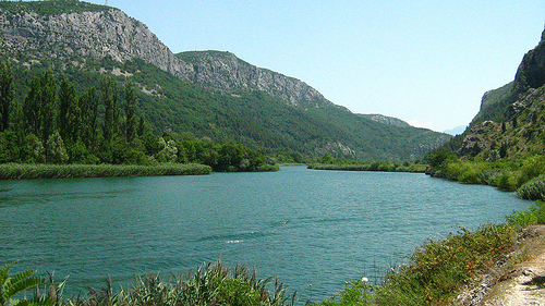
Cetina Valley Nature Park is situated in the southern Croatia.
It protects biosphere around the Cetina river and Cetina Valley
at a total length of 101 km (63 miles). With its beautiful views
and challenging rapids Cetina Valley Nature Park is popular for
its rafting and kayaking.
Presence of first humans in
the area of Cetina Valley Nature Park date back to the Early
Bronze Age. Human remains were buried in the mounds that are
still visible on the bank of the river, especially in the lower
part of its flow around Cetina, Vrlika and Bajagic. Their
distinct shape make its hard to confuse with surrounding cliffs.
There are not that many opportunities for hiking in the
valley. It is due to lack of suitable hiking paths as well as
minefields that the local residents claim to litter the ground
since World War II and recent Yugoslavian Civil War. It is hard
to prove or disprove the validity of these statements, but you
would not want to risk your life to achieve that.
The name Cetina was named by Croats coming from the area of present-day Poland after the Polish River Cetyinii. The delmatae called her Kentona.
Cetina Springs at an altitude of 385 m in the northwestern
slopes of Dinara near the village of Cetina, 7 km north of
Vrlika. It has multiple springs, with the main limestone spring
being a lake over a hundred meters deep. Above the source of the
Cetina River, north of Vrlika, there is Gospodska cave, famous
for its population in prehistoric times.
A few kilometers
downstream from the source Cetina flows into Perućko Lake. That
place is called Garjak. There are lots of beaches and beaches.
Perućko Lake was artificially created near Vrlika by a dam on
Cetina 25 km downstream from the source. After the lake, the
river passes the karst area and the Sinj field towards the town
of Sinj. Cetina under Gardun, near the town of Trilja, leaves
Sinjsko polje, enters the gorge and flows south. Above the gorge
is the Fort Nutjak. The banks in the gorge are closer and
higher, and the river is deep and slow. At one time, water
flowed quickly and turned the mills, but the dams slowed it
down. Cetina near Bisk turns towards the southeast, and from
there it is followed by the A1 highway. Cetina near Šestanovac
turns towards the South, passes under the A1, and soon after
near Zadvarje turns around Mosor and continues to flow towards
the West. In Omiš it flows into the Adriatic Sea.
During
the summer tourist season, in the lower reaches of Cetina (from
Slimen to Radman's Mills near Omis), rafting takes place daily,
twice a day for 3 to 4 hours.
The left tributaries of the Cetina are Rumin, Kosinac and Ruda.
Dragović and Dabar are also left tributaries, but are submerged
by Lake Peruća. It is the main right tributary of the Vojskovo
(also mentioned in literature as Vojskava). Just before the
confluence with the Cetina, the Karakašica flows into Vojskovo,
so it is mentioned in literature in some places as a right
tributary of the Cetina (not the Vojskova). There are many
smaller rivers and springs (such as the three hundred and sixty
Vril which flows into the Cetina). Only in the wider area of the
village of Hrvaca there are more than 50 Springs (which have a
name).
The three largest springs of Cetina are Vukovića
vrilo, Batića vrilo and Veliko vrilo, which together form the
whole of the Cetina Springs, with an area of 29.81 ha. This
series of karst Springs formed along the edge of the Pag field
at the foot of the Dinara. They were formed on the contact of
impermeable marbles in the field and the water-impermeable
limestones of the surrounding plateau. They are ascending
species. They are bright and blue-green in color.
These 3
springs are Lake Springs (limnokreni) and ascending Springs,
which is a feature of many Croatian karst rivers.
From the source to the entrance to the canyon below Trilj, along Cetina are several fields, in order: Paško polje, Cetinsko polje (these two are directly next to the sources of the river), Vrličko polje, Koljansko and Ribarićko polje (these two are submerged by Lake Peruća), Hrvatačko polje, Sinjsko polje (the largest one), within which is Grabsko polje.
Along Cetina there are several medieval and ancient fortresses (forts, historical towns). Above the spring is Glavaš, on the right side above Vrlika is a window, and lower in the area of Potravlje and Satrić Travnik, and even lower Sinj fortress Stari grad (Sinj). On the left near Trilj is Čačvina, and on the right, above the canyon, directly below Trilj Nutjak. On the left side of the canyon in Zadvarje is the fortress Zadvarje. Near the mouth is the Fortress Kunjak in Kučići, and directly next to Omiš Visuć, Mirabela (Peovica) and Fortica (Starigrad).
The hydro power system of the Cetina River includes: HPP Peruća,
HPP Orlovac, CS Buško blato, HPP Đale, HPP Zakučac and HPP
Kraljevac.
HPP Peruća
Perućko Lake is the first large
artificial lake in karst terrain and the first remote
accumulation of the Cetina River Power system. The useful volume
of the lake significantly affects the leveling of the flow of
Cetina on the downstream energy steps from Sinjsko Polje to the
Adriatic Sea. The drop concentration achieved by the
construction of the peruća dam is used in the pribranska
hydroelectric power plant Peruća.
HPP Orlovac
HPP
Orlovac is a high pressure derivation plant whose facilities are
located in two countries: an artificial lake with associated
facilities and one part of the supply tunnel are in Bosnia and
Herzegovina, and the other part of the supply tunnel, water
chamber, pressure pipeline, engine house and drainage channel
are in the Republic of Croatia. Apart from the artificial lake
Buško blato, there is also an artificial lake Mandak. If the
flow from Livanjsko Polje exceeds the needs of hydroelectric
power plants, the reversible Lipa - Buško blato channel is
transferred to the buško blato artificial lake by means of the
Buško blato pumping station (CS Buško blato).
HPP Djale
HPP Đale is located in a gorge of the Cetina River downstream
from Trilj, and uses the energy potential at a drop of 21 meters
between Sinjsko Polje and the artificial lake Prančevići. It
uses already regulated waters of the Cetina river for
production.
HPP Kraljevac
HPP Kraljevac is located 21
kilometers from the mouth of Cetina into the sea and after 1932.
the second phase, with a total installed capacity of 67.2 MW,
was the largest hydroelectric power plant in this part of Europe
at the time. After the commissioning of the second phase of HPP
Zakučac in 1980., He Kraljevac lost its earlier importance.
HPP Zakučac
HPP Zakučac is located at the confluence of
the Cetina river with the sea near Omiš. According to the power
and production, HPP Zakučac is the largest plant in the Cetina
River Basin, accounting for approximately 69% of the total
annual production.
Fish
In the Cetina River Basin, 18 species of freshwater fish
have been recorded. Six species are local species, while 12
species of fish have been introduced from other natural and
breeding habitats.
There are five endemic species:
the
Illyrian clove (Squalius illyricus) is a Croatian endemic
distributed in the basins of the Rivers Cetina and Krka, and in
the area of Cetina it is found in the river Ruda.
stenoendem
Cetina gorge (Telestes gorge) resides mostly in the Springs,
tributaries and reservoirs of Cetina, and is kept above sand and
gravel, while in the unfavorable part of the year it enters the
pools of groundwater.
stenoendem Dalmatian meander (Cobitis
dalmatina) inhabits slow-moving streams and quiet parts of the
river, in areas where the water is cooler and where the bottom
is sandy, gravel or overgrown with dense vegetation;
oštrulja
(aulopyge huegelii) is an endemic of the Dinaric Karst and
inhabits flowing waters, mostly sinkholes, and in the autumn
period goes into groundwater.
pijurica (Phoxinellus
alepidotus) is a closely distributed species of the Cetina River
around the Sinj field. The only known habitat of this species is
Miloševo and Stipančevo Lake in Hrvatački Polje.
the catfish
(Salmo sp. Cetina) is the dominant fish in Cetina, found in all
areas from the source and downstream.
zubatak (Salmo dentex
chondrostoma phoxinus
coastal Trout (Salmo farioides) the
presence is a consequence of porridge.
Black Sea Trout Salmo
labrax,
brook trout (Salmo trutta,
California cutthroat
trout (Oncorhynchus mykiss
carp (Cyprinus carpio) and
Pike
("Esox lucius") are species introduced into the habitat by
leaching.
Molluscs
Most native species belong to
freshwater and subterranean snails of the family Hydrobiidae and
are bioindicators of environmental conditions. They are the
genus Dalmatinella and the species Bithynia cettinensis, Horatia
klecakiana and Kerkia jadertina.
Cetina Valley Nature Park is obviously most famous for its rafting. Cetina river is a combination of scary cascades and areas of quiet flow. Most of tourists began their journey from a town of Omis. Rafting is usually held between April and October and might take up to 3 hours for a total trip. Lush forests around Cetina river make it virtually impossible to get on dry land so once you begin your trip there is no turning back. Eventually you will make your way to the artificial lake of Peruca.