Location: Map
Area: 140 islands, total 320 km2 (124 sq mi)
Ferry from Biograd, Murter, Primosten, Rogoznica, Vodice, Zadar
Info: (022) 435 740
“On the last day of Creation, God wanted to crown his work and from tears, stars and breath created the Kornati” (JB Shaw)
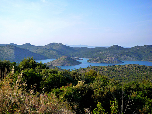
Kornati Islands National Park (Nacionalni park Kornati) is a stunning marine-protected archipelago in central Dalmatia, Croatia, renowned for its labyrinth of karst islands, crystal-clear waters, and rugged cliffs. Established in 1980, it encompasses 89 islands, islets, and reefs out of a total 152 in the Kornati group, covering approximately 220 square kilometers (85 square miles), with about 75% of the area being sea. Often described as the most indented archipelago in the Mediterranean, it features a minimalist, almost lunar landscape with sparse vegetation, making it a haven for sailors, divers, and nature enthusiasts seeking solitude. The park is part of a UNESCO Tentative List site alongside Telašćica Nature Park, highlighting its exceptional natural and cultural value. With no permanent residents on most islands, it offers a pristine escape, though seasonal fishermen's cottages and restaurants dot the area.
Geological Formation: Foundations of a Karst Archipelago
The
Kornati landscape is a product of tectonic activity and karst processes
over tens of millions of years. The islands sit on the southern edge of
the Eurasian tectonic plate, near the boundary with the African plate
under the Mediterranean (remnant of the ancient Tethys Ocean). Africa’s
ongoing northeastward movement has caused the Eurasian plate’s southern
margin to wrinkle, fault, rise, and subside repeatedly.
~100
million years ago (Late Cretaceous): The area was submerged in the warm
Tethys Sea. Sediments from marine organisms formed thick layers of
limestone and dolomite, rich in fossils of shells, crustaceans, and
fish—still visible today.
70–80 million years ago (end of
Cretaceous): Tectonic uplift exposed parts of the land. The famous
Kornati “crowns” (steep cliffs) are remnants of massive fault planes;
some drop over 90 meters into the sea, while others rise 80+ meters
above it.
~65 million years ago: A major asteroid impact (linked to
the K-Pg extinction) affected global life, but karstification
(dissolution of limestone by rainwater) began intensifying, creating
caves, sinkholes, and other classic karst features.
~35 million years
ago (end of Eocene): Final major uplift left the area above sea level.
Further karst processes sculpted the porous, dry terrain.
Last Ice
Age (~15,000 years ago): Sea levels were ~130 meters lower, connecting
the Kornati hills to the mainland. Post-glacial warming and rapid
sea-level rise (around 9,000–2,400 years ago) submerged lowlands,
fragmenting the area into the current islands. Some underwater caves and
formations became marine habitats.
The result is a stark, rocky,
largely treeless seascape—porous limestone drains quickly, supporting
only sparse vegetation despite centuries of human modification.
Prehistoric and Ancient Human Presence (Neolithic to Byzantine Era)
Humans have interacted with the islands for millennia, though permanent
settlement was always limited by the harsh, water-scarce environment.
Neolithic (~Stone Age): Earliest evidence is a stone axe found near the
Trtuša field on Kornat Island (now in Zadar’s Archaeological Museum),
indicating sporadic presence.
Illyrian/Liburnian Period (Iron Age,
~4th–1st centuries BCE): The first confirmed colonization by Illyrian
(specifically Liburnian) tribes. They built small rectangular stone
dwellings (individual or clustered, e.g., below Pedinka, above
Željkovci, or on Žut Island), hillforts (gradine like Ščikat, Stražišće,
Tureta, Grba), and burial mounds/barrows on most rises. They were
primarily herders (sheep/goats) with fishing as a key economic activity;
Liburnians were skilled seafarers whose ship designs influenced the
Romans.
Roman Era (1st century BCE–5th century CE): Romans exploited
the islands for villas (villae rusticae, e.g., in Proversa), fish ponds
(e.g., on Svršata), harbors, piers (some now underwater), saltworks
(e.g., Šipnate), and stone quarries. Sites like Stražišće, Tarac,
Levrnaka, and Lavsa show active life. Some scholars believe Roman
development disrupted earlier Illyrian continuity. Mosaics and other
remains attest to wealthy Roman presence.
Byzantine/Early Medieval
Period (~6th century CE onward): The most iconic structure is the Tureta
(or Toreta) fortress on Kornat Island—a late antique/early medieval
military tower likely built in the 6th century (possibly under
Justinian) to control Adriatic shipping routes. Below it lies an early
Christian three-nave basilica of St. Mary (foundations and apse visible;
~30x13m, suggesting a sizable population). The island was sometimes
called Insulae Sanctae Mariae. Nearby foundations may indicate a
monastery (Templar or Benedictine). A smaller rural Romanesque church of
Our Lady of Tarac (Gospa od Tarca) later replaced an earlier basilica.
Medieval to Early Modern Period: Venetian Rule, Fishing, and
Pastoral Use
After the decline of Byzantium and amid Croatian
settlement on the mainland, the islands saw instability. By the Middle
Ages, they became part of Venetian territories (long occupation from the
Middle Ages to late 18th century). They served as resupply points for
the Venetian fleet and fishing grounds.
Piškera Island hosted a
medieval fishing settlement with warehouses and storage.
Fishing
thrived (especially sardines); Sali fishermen from Dugi Otok held key
rights. In 1524, Venetians built a tax fortress on Vela Panitula; a
seasonal fishing village on Piškera (36 huts, docks, church consecrated
1560) operated during summer “dark” fishing periods.
The islands were
used for seasonal herding and pasture. Deforestation and periodic
burning of scrub for sheep/goat grazing caused erosion and barren
landscapes.
After Venice’s fall (late 18th century), the islands
passed to Zadar nobility. The Piškera fortress and settlement were
largely abandoned.
17th–19th Centuries: Colonization by Murter
Locals and Land Ownership Shifts
From the 17th century, overcrowding
on nearby Murter Island (due to Turkish refugees and mainland pressures)
led Murterini (and some from Betina/Zaglav) to become tenants/shepherds
(“Kurnatari”) for Zadar nobles. Sali fishermen continued traditional
rights, leading to conflicts. Rural complexes (stanovi)—seasonal
shelters in fields and coves—emerged.
Late 19th century: Agrarian
reforms and taxes forced Zadar nobility to sell. Murter locals bought
Žut Island in 1885 and most of Kornat and associated islands in 1896
(now owning ~90% of the land). This marked the shift to local private
ownership that persists today.
20th Century: Peak Agriculture,
Decline, and Rise of Tourism
Early 20th century saw maximum land
clearance: ~18,000 olive trees planted, small vineyards, and an
extraordinary network of dry-stone walls (totaling ~320–330 km) built
without mortar to divide pastures, protect groves, and mark boundaries.
These walls are a defining cultural landscape feature, shaped by human
labor over centuries.
Sheep herding and burning of pastures continued
(contributing to the “lunar” look). From the 1920s–1970s, traditional
activities declined as younger generations moved to cities. Motorboats
made the islands more accessible. Tourism emerged in the 1970s; locals
adapted seasonal houses in coves (e.g., Vrulje, Kravjačica, Lavsa) for
visitors. There are no permanent residents—only seasonal use by owners
from Murter and nearby areas.
A notable 20th-century curiosity: In
1959, a fishing village set was built on Mana Island for the film As the
Sea Rages; stone ruins remain visible today.
Establishment of the
National Park (1965–Present)
Protection efforts began in the mid-20th
century:
1965: First written proposal by geographer Sven Kulušić,
arguing for preservation as a “monument to human labour” and potential
national park.
1967: Declared a natural area reservation (lowest
level of protection; no dedicated management).
1976: Study proposed a
spatial plan for national park status.
1980 (August 13): Parliament
of SR Croatia officially established Kornati National Park (“Narodne
novine” 13/80), initially including Lower Kornati plus southeast Dugi
Otok and Telašćica Bay.
1981–1986: Separate management bodies in
Šibenik and Zadar; later unified under a single organization.
1988:
Due to management disputes, Telašćica Bay split off as a separate Nature
Park; Kornati retained its name and larger share (~223.75 km² initially;
later adjusted).
1997: Minor boundary changes (now ~217 km² with 89
features).
2000s–2010s: Updated spatial plans, nature conservation
laws, and ordinances on park rules. Management is by the public
institution based in Murter. The park’s three core goals: protect the
landscape, safeguard marine ecosystems, and preserve centuries-old
traditional heritage.
The land remains mostly privately owned (by
Murter families), with strict regulations on fishing, development, and
visits to balance conservation with traditional use and nautical tourism
(a major draw today).
Location and Overall Extent
The full Kornati archipelago
(sometimes called the Stomorski islands) covers approximately 320 km² of
sea area and includes around 140–150 islands, islets, and reefs. It
stretches roughly 35 km in length and 13 km in width, running from
Balabra in the northwest to Samograd in the southeast, and from Gangarol
in the northeast to Mana in the southwest.
The national park,
established in 1980, covers the 89 southernmost islands, islets, and
reefs (primarily the Donji Kornati group). It spans about 218 km²
(figures sometimes cited as 217–220 km²), of which the land area is less
than one-quarter—slightly under 50 km²—meaning the sea overwhelmingly
dominates the park. The total coastline length of all islands within the
park is 238 km. The average island size in the park is about 0.5 km²;
excluding the largest island (Kornat at 32.5 km²), the average drops
below 0.2 km². Many of the 89 features are tiny—76 are under 1 hectare.
Geographical Division
The archipelago naturally divides into two
groups:
Gornji Kornati (Upper Kornati): Closer to the mainland,
including the northernmost island of Sit and its surrounding islets,
separated by a channel from Žut (the largest and most indented island in
this group) and its islets.
Donji Kornati (Lower Kornati): Facing the
open sea to the southwest; these form the core of the national park and
include the largest island, Kornat (after which the whole group is
named). A channel separates Kornat from Piškera and its surrounding
islets.
Key islands and features within or near the park include
Kornat (largest, 25.2 km long but no wider than 2.5 km), Žut, Levrnaka
(fourth largest), Lavsa, Mana, Piškera, Panitula Vela, Smokvica Vela,
Ravni Žakan, Svršata Vela, Samograd, Tarac (second-largest karst rock
area), and smaller sites such as the oval-shaped Taljurič, shallow Mala
Proversa channel, Špinuta Bay, Stivina Bay, and Lavsa Bay. Purara is a
notable marine reserve.
Topography and Landforms
The terrain
is classic karst—porous, rugged limestone and dolomite that creates a
barren, otherworldly landscape. Most islands appear stark and rocky,
with only about 5% cultivated land and 85% stony ground. Vegetation is
sparse due to the dry conditions and historical human impact
(deforestation, grazing, burning).
The most iconic feature is the
“crowns” (krune or stene)—dramatic vertical cliffs and crags on the
southwestern (seaward) edges of many outer islands. These are exposed
fault planes formed by tectonic movement. They rise steeply (up to 82 m
above sea level on Klobučar Island) and plunge even deeper underwater
(over 90 m in places, such as at Piškera). These cliffs create a sharp,
crown-like silhouette against the sea and are a defining visual and
geological hallmark of the park.
Other karst features abound: caves,
grottos, sinkholes, cracks, flat rock pavements, and bizarre atmospheric
erosion forms. The highest point in the park is Metlina peak on Kornat
Island at 237 m. The deepest sea point near the islands is 125 m, found
close to the Purara islet.
Bays and inlets provide sheltered
anchorages, while the highly indented coastline (one of the most
indented in the Mediterranean) creates a maze-like nautical environment.
Geology and Formation
The islands sit on the southern edge of the
Eurasian tectonic plate, near the boundary with the African plate (whose
northeastward movement causes subduction under Eurasia, earthquakes,
faulting, and vertical block movements).
Rock origins: The oldest
rocks are Upper Cretaceous dolomites and limestones (~100 million years
old), deposited in the ancient warm Tethys Ocean. These contain abundant
fossils of marine organisms, including rudist bivalves and other
shellfish.
Tectonic history: Around 70–80 million years ago
(end-Cretaceous), tectonic uplift exposed parts of the area. A
~30-million-year “dry land” phase allowed intensive karstification
(caves, pits, sinkholes). A major asteroid impact ~65 million years ago
contributed to mass extinctions visible in the fossil record.
Later
cycles: The area submerged again ~35 million years ago (end-Eocene),
forming brackish basins with foraminiferal limestones (visible at sites
like Lavsa, Ravni Žakan, and Kornat). Flysch sediments appear in small
areas (e.g., Gujak Bay on Kornat). Further uplift and karstification
followed.
Quaternary changes: During the last Ice Age (~15,000 years
ago), sea levels were >130 m lower, connecting the Kornati hills to the
mainland. Post-glacial warming caused rapid sea-level rise, isolating
the hilltops as islands and submerging many karst features (now
underwater habitats). Kornat may have connected to the mainland as
recently as 9,000–10,000 years ago and to Dugi Otok even later.
This long history of marine sedimentation, tectonic faulting, karst
dissolution, and sea-level fluctuations explains the current rugged,
porous, and dramatically sculpted landscape.
Climate
Kornati
has a classic Mediterranean “olive” climate (Csa): moderately warm with
hot, dry summers and most rainfall in autumn. Because of the park’s
small size and low elevation, conditions are remarkably uniform across
the islands.
Temperatures: Annual average ~16 °C. January average
7.3 °C; July 23.9 °C. Monthly averages range from 8 °C (February low) to
25 °C (July/August high). Extreme records: 36.4 °C high, –3.8 °C low.
There are ~270 days >10 °C, ~40 hot days (≥30 °C) per year, and only ~4
cold days (<0 °C).
Sunshine and clouds: 2,600–2,700 hours of sunshine
annually (very high). Summers are especially sunny (~11 hours/day in
August, only ~2 cloudy days). Winter cloud cover is higher but still
moderate.
Precipitation: Dew is abundant (partly compensating for low
rain due to sparse vegetation). Rain peaks in October; nearly every
cloudy day brings precipitation.
Winds: Bura (northeasterly) is the
most frequent (19.4% of the year) and can be strong; jugo
(southeasterly) is the strongest wind. Maestral (northwesterly sea
breeze) dominates summer. Winds are mostly light (1–3 Beaufort, 70% of
the time); strong winds (≥6 Beaufort) occur on ~37 days/year, with
storms on ~5–6 days (mostly December). Calm conditions prevail 15.4% of
the time.
Sea temperatures: 14–15 °C in winter, 22.8 °C in summer.
The combination of intense sunlight, drying bura winds, and porous
karst bedrock makes the islands exceptionally arid and contributes to
their barren beauty.
Kornati's biodiversity is predominantly marine, boasting one of the richest underwater ecosystems in the Adriatic. The seas host over 850 animal species, including 353 algae, 177 mollusks, 127 bristle worms, and 61 bryozoans, along with vibrant corals, sponges, and sea anemones. Fish populations are diverse, featuring sardines, tuna, groupers, and endangered species like the loggerhead sea turtle and Mediterranean monk seal. Terrestrial life is sparser due to the arid conditions, with about 540 plant species, including endemic sage and olive trees, adapted to rocky soils. Fauna includes reptiles like the Balkan green lizard, birds such as peregrine falcons and Eurasian eagle-owls, and introduced sheep that graze the islands. Conservation efforts focus on protecting these habitats from invasive species, pollution, and climate change impacts like rising sea temperatures.
Standout attractions include the dramatic cliffs of Mana Island, offering panoramic views and hiking trails to viewpoints like Metlina (237 meters/778 feet). Historical sites abound, such as the Byzantine Tureta church and fortress, Illyrian ruins, and WWII submarine pens. The park's underwater world is a diver's paradise, with sites like the Rasip Wall (colorful gorgonians) and numerous wrecks. Popular activities include sailing (with over 100 safe anchorages), kayaking, snorkeling, and guided boat tours exploring hidden coves like Lojena Beach. Fishing is regulated, requiring permits, while hiking trails on Kornat provide insights into traditional olive groves and stone walls. Nearby Telašćica adds saltwater lakes and dolphin sightings.
1. Best Time to Visit
Shoulder seasons (May–June or
mid-September–early October) are ideal: warmer seawater (still swimmable
in September), fewer crowds, lower prices, and pleasant temperatures
(around 20–28°C / 68–82°F). Seas are calmer, and you’ll have more space
in popular bays.
Peak summer (July–August) brings hot days (upper
20s–30s°C / 80s–90s°F), multiple daily tours, and busier anchorages—but
it’s still beautiful if you book early and start early to beat the heat.
Avoid winter unless you’re an experienced sailor (fewer services,
rougher seas). The park is open year-round, with 2,700 hours of sunshine
annually.
2. How to Get There & Access Options
Kornati has no
ferries or roads—you must arrive by sea. Main departure points are on
the mainland or nearby islands: Zadar, Biograd na Moru, Šibenik, Murter
Island, or Dugi Otok.
Organized day tours (most popular for
first-timers): Full-day boat excursions (8–10 hours) from Zadar or
Murter are easiest. Small-group boats (70–180 passengers) include
entrance ticket, guide, swimming/snorkeling stops, and often lunch
(grilled fish or similar). Prices: ~35–66€ per adult (children
half-price or free under 4). Book via reputable operators like Plava
Laguna or local agencies—many depart daily in season.
Private charter
or skipper boat: Rent a speedboat/sailboat with captain for flexibility
(custom stops, longer swims). Prices vary but include fuel and tickets.
Own boat or bareboat charter/yacht: Perfect for freedom—explore at your
pace and overnight in designated spots. You’ll need a valid skipper’s
license if chartering without crew.
Kayaking or sailing regattas: For
active travelers; full-day guided kayaks or events like the Kornati Cup
(April).
Pro tip: Tours often combine Kornati with nearby
Telašćica Nature Park (on Dugi Otok) for extra bays and a saltwater
lake.
3. Tickets & Fees (2026 Prices)
Tickets are per boat
(not per person) for private vessels and valid from 00:00 on the entry
day until noon the next day. Buy in advance online (cheaper) via the
official shop (shop.np-kornati.hr or parkovihrvatske.hr) or mySea
app—prices jump if bought inside the park.
Individual entrance
tickets (per boat, outside purchase – cheapest):
Low season
(Jan–May, Oct–Dec):
<7m: 25€ (1 day) / 45€ (3 days) / 65€ (5 days)
7–11m: 30€ / 65€ / 95€
11–18m: 50€ / 95€ / 145€
High season
(June–Sept): Roughly double (e.g., <7m: 45€ / 90€ / 130€).
Day-tour participants usually have the ticket included—no separate
purchase needed. Multi-day passes save money for yachts. Non-refundable;
one-time date change possible via email in emergencies.
4. Park
Rules & Regulations (Strictly Enforced)
Kornati is highly
protected—follow these to avoid fines:
Prohibited: Lighting fires
(except designated spots), picking plants or disturbing wildlife,
recreational fishing (special permit only), camping outside authorized
zones, littering/polluting, introducing non-native species, climbing
cliffs in restricted areas, spearfishing.
Anchoring/overnight: Only
at 16 designated bays/coves (e.g., Stiniva, Lavsa, Piškera) with buoys
or moorings—wild anchoring damages seabeds.
Diving: Only in
designated zones via authorized centers (no independent recreational
diving).
Speed limits and noise restrictions apply.
General: Take
only photos, leave only footprints. Rangers patrol.
Read the full
“Rules of Conduct” and “Enjoy Your Vacation Responsibly” on
np-kornati.hr before arrival.
5. What to See & Do (Highlights &
Sample Itinerary)
Focus on swimming, snorkeling, light hiking, and
relaxing—the park’s magic is in its seascape.
Must-see spots:
Lojena Beach (Levrnaka Island): The only sandy beach in Kornati—white
sand, turquoise shallows, great for swimming/sunbathing. Nearby
restaurant (Konoba Levrnaka).
Tureta Fortress (Kornat Island):
6th-century Byzantine ruins on a hill with panoramic views. Short steep
hike from the bay—worth it for history and vistas.
Mana Island:
Dramatic cliffs, film-set ruins (from an old Greek village movie),
excellent snorkeling and cliff jumping.
Other bays: Smokvica, Strunac
(Lavsa), Piškera marina (with restaurant). Look for sea turtles,
dolphins, or rich underwater life (fish, moray eels, coral).
Hiking:
Marked trails on Kornat (to Metlina peak) or educational paths on
smaller islands. Start early—little shade.
Sample full-day tour
itinerary (typical):
Morning departure → sail through the archipelago
→ swimming/snorkeling stop → lunch at a konoba (tavern) → visit Tureta
or a beach → afternoon free swim → return by sunset.
For
multi-day yachting: Moor in different bays nightly, explore at leisure.
6. Practical Tips for a Smooth Visit
What to bring: Sunscreen
(high SPF—no shade!), hat, sunglasses, reusable water bottle,
swimsuit/towel, snorkel mask & fins (rentable on some boats),
comfortable shoes for hiking, cash (limited ATMs/card acceptance in
remote spots), light snacks, camera/phone in waterproof case. No need
for heavy gear—keep it simple.
Sun & safety: Exposed terrain gets
hot; hydrate and take breaks. Seas are generally calm inside the park
but check forecasts (maestral winds common).
Food & facilities: Very
limited—pack water/snacks or eat at konobas (fresh seafood, lamb, local
wine). No shops except occasional summer ones. Toilets are basic at
mooring spots.
Money & bookings: Book tours/boats weeks ahead in peak
season. Cash is king on islands.
Sustainability: Use reef-safe
sunscreen, don’t feed wildlife, respect mooring rules.
Where to stay:
No hotels inside the park. Base on Murter Island (closest, with
guesthouses) or Zadar/Šibenik for easy access. For overnights in the
park: rent fishermen’s houses via agencies or stay on your yacht.
7. Insider Tips & Final Advice
Go private if possible: Day tours
are great value, but a skipper-led boat lets you avoid crowds and linger
in secret coves.
Combine with Telašćica: Many tours do both parks for
maximum variety (cliffs + lake).
Photography: Sunrise/sunset sails or
drone views (if permitted) are magical. The “staircase” cliffs and
endless blue are iconic.
For families: Kid-friendly with swimming
stops; choose smaller boats.
Check official updates: Visit
np-kornati.hr for the latest prices, weather, and rules (English
available). Contact: +385 22 435 740 or kornati@np-kornati.hr.