Rovinj is a small town 30 km north of Pula and is situated on the
shore of the Adriatic sea. Although technically a Croatian town for
most of its history this was an Italian city. To this day Italian is
spoken even by the Croats who live in Rovinj. Most of the old
quarter is inaccessible to cars since streets are too narrow. This
only adds to the charm of this pleasant town. Rovinj has many hotels
and small restaurant with incredible pizza calzone that is the best
you will ever taste. In the centre of the city stands church of
Saint Euphemia from the 18th century. Her statue on the bell tower
holds a ship wheel. Sailors and fisherman came here to pray for
divine protection and names of those who did not return are engraved
on some of the stones around the courtyard. It was the only
consolation for families who did not receive the body from a sea.
Other interesting buildings include Chapel of Holy Trinity (13th
century) and Rovinj Town Hall build in Baroque style (17th century).
In the west and southwest, the city is surrounded by the
Adriatic Sea, in the north of the Limski Canal. Originally Rovinj
was a separate island, which was only in 1763 connected to the
mainland. To the east lies the suburb of Rovinjsko Selo and about 25
kilometers further to the town of Kanfanar. In the southeast is the
suburb Kokuletovica and about nine kilometers further the community
Bale.
About one kilometer south of the old town of Rovinj is
Zlatni rt (Golden Cape), another peninsula rising into the sea. On
more than 70 hectares, a more than 100-year-old park, now under
conservation, stretches out here. Rovinj and its bays are surrounded
by 22 smaller and larger islands. The largest of these islands, the
Sveta Katarina, is within sight of the peninsula of the old town.
Still further south behind Zlatni rt lies Sveta Andrija. A dam
connects the island with the smaller neighboring island of Maskin.
1. Old Town (Stari Grad / Rovinj Peninsula)
The entire old town is
the star attraction: a maze of narrow, winding cobblestone streets,
steep stairways, pastel-colored stone houses with ornate chimneys,
hidden squares, and sea-facing balconies. Limited space on the peninsula
forced vertical, tightly packed building, creating an atmospheric
labyrinth perfect for wandering without a map. Venetian-style
architecture dominates—think arched doorways, shutters, and laundry
lines fluttering above alleyways.
Historical context: Traces back to
early Christian and Roman times, but flourished under Venice. It served
as a fishing port and defensive outpost.
Highlights inside: Art
galleries, boutiques, and cafés line the alleys. Many streets lead to
the sea, with ladders for swimming right off the rocks.
Visiting:
Best explored on foot (car-free). Sunset or early morning avoids crowds.
The town feels like a living museum rather than a checklist of sites.
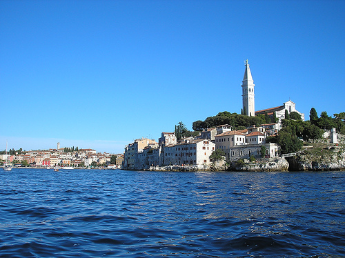
2. Cathedral of Saint Euphemia
(Crkva Sv. Eufemije / Basilica of St. Euphemia) and Bell Tower
This
Baroque hilltop church is Rovinj's most iconic landmark, visible from
almost everywhere in town and the harbor. It crowns the old town's
highest point and dominates postcards and skyline views.
History and
architecture: Built 1725–1736 on the site of earlier early Christian
churches (originally dedicated to St. George). The current three-nave
structure is the largest Baroque church in Istria. The Venetian-Baroque
façade was added later (mid-20th century). Inside: ornate altars,
15th–17th-century artworks (including The Last Supper and Christ in
Gethsemane), Gothic statues, and stained glass.
The relics and
legend: The church houses the relics of St. Euphemia (a 4th-century
martyr) in a 6th-century Roman sarcophagus (adapted in the 15th
century). Local legend says the sarcophagus miraculously floated ashore
in 800 AD during a storm; townspeople couldn't move it until a pious boy
and oxen succeeded, guided by the saint herself.
Bell tower: A
separate 60-meter (197 ft) tower built 1654–1680 by Antonio Manopola,
modeled directly after the campanile of St. Mark's Basilica in Venice.
At the top is a copper statue of St. Euphemia that acts as a weather
vane (turning with the wind). Climb the 192 creaky wooden steps (small
fee, cash only) for 360° panoramic views over red rooftops, the harbor,
islands, and open sea—especially magical at sunset.
Visiting: Free
entry to the church; tower climb is worth it for views. Open daily;
check for mass times.
3. Balbi's Arch (Balbijev Luk)
This
elegant 17th-century stone archway serves as the grand entrance to the
old town from Tito Square (Trg Marsala Tita), near the harbor.
History: Built in 1679 (or 1678 in some accounts) by local mayor Daniel
Balbi on the site of an earlier town gate. It replaced part of the
medieval fortifications.
Architecture and symbolism: Venetian-style
with a prominent relief of the Lion of St. Mark (symbol of Venetian
power) on the seaward side. Look closely: a carved "Turk's head" on the
outer face and a Venetian noble's head on the inner side—reflecting the
era's tensions between Venice and the Ottomans.
Significance: Marks
the transition from the waterfront into the historic core. It's a
photogenic gateway and symbolic reminder of Rovinj's Venetian heritage.
Visiting: Pass under it en route to Grisia Street; free and always
accessible.
4. Grisia Street
The main pedestrian artery of the
old town runs from Balbi's Arch uphill toward St. Euphemia's Church.
It's a lively, stepped cobblestone lane lined with stone houses, art
galleries, souvenir shops, and outdoor cafés.
History: Dates to
medieval times; the name "Grisia" refers to the grey stone originally
used for paving.
Atmosphere: Bustling yet charming, with artists
displaying work outdoors in summer. It captures the town's creative,
bohemian side.
Visiting: Stroll slowly—it's short but packed with
photo ops and local flavor.
5. Port of Rovinj (Harbor) and
Seafront Promenade
The lively working harbor at the base of the old
town features colorful fishing boats, batana (traditional flat-bottomed
boats), ferries to nearby islands, and yachts. The promenade wraps
around the peninsula with sea views, cliffside bars, and swimming
ladders.
Significance: Heart of daily life and tourism; perfect
for people-watching, boat trips, or sunset strolls.
Nearby: Tito
Square with its clock tower (a 17th-century remnant of the town walls).
6. Forest Park Punta Corrente (Zlatni Rt / Golden Cape)
Just
south of town (a short walk or bike ride), this 52–70-hectare protected
nature park is a standout natural landmark complementing the historic
core.
Golden Cape Forest Park | Golden Cape Forest Park Rovinj
Istra-Istria - official tourism portal
History: Transformed in the
late 19th century by Trieste entrepreneur Count Georg (Johann)
Hütterott, who bought land and began afforestation for a envisioned
health resort. It features exotic species (Himalayan cedars, cypresses,
pines) along with native flora. Protected as a special site in 1948 and
forest park in 1961—the first in Istria.
Features: Dense forests,
tree-lined paths, rocky coves, meadows, and bays (Lone Bay, Škaraba).
Ideal for swimming off rocks, hiking, cycling, or picnics.
Visiting:
Free entry; rent bikes or walk from town. Great escape from crowds.
Other Notable Sights
Town Walls and Gates: Medieval
fortifications (7th century onward) with preserved sections and gates
like St. Benedict's, St. Cross, and "Under the Wall."
Franciscan
Monastery (early 18th century, Baroque) with a library and sacral
museum.
Rovinj Heritage Museum and Batana Eco-Museum
(UNESCO-recognized traditional boat heritage).
Nearby islands (short
boat rides): St. Catherine (Sv. Katarina) and Red Island (St. Andrew's)
with historic buildings and beaches.
Best Time to Visit
Ideal periods: May–June or September–October.
Warm weather (22–25°C/72–77°F), swimmable sea (~22°C), fewer crowds, and
lower prices than peak summer.
Peak summer (July–August): Hot,
crowded, and expensive—great for beach vibes but book everything early.
Shoulder/low season: April or October–November offers mild weather and
serenity, but some spots close and swimming cools off. Winters are quiet
and chilly.
Mornings are peaceful before day-trippers arrive;
evenings buzz with waterfront energy.
How Many Days?
2–3 days:
Enough for old town highlights, swims, and a relaxed pace.
4–5+ days:
Ideal as a base for Istria day trips (e.g., hill towns, Pula).
Getting There & Around
By air: Fly into Pula Airport (~40–60 min
drive/shuttle). Other options include Trieste or Venice (then ferry).
By car: Easy roads; park in lots like Valdibora outside the
pedestrian-only old town (don’t drive in).
By bus/ferry: Good
connections from Pula/Poreč; seasonal catamarans to Venice.
Getting
around Rovinj: Mostly walkable. Rent bikes for Golden Cape Park. Taxi
boats to islands. Cars useful for day trips.
Pro tip: Wear
comfortable shoes—cobblestones are slippery when wet, and there are
hills/stairs.
Top Things to Do
Wander the Old Town — Get lost
in narrow alleys, colorful houses, art galleries, and Grisia Street
(main shopping lane). Visit Balbi Arch at the entrance.
Climb St.
Euphemia Church & Bell Tower — Iconic Baroque landmark at the highest
point. Free entry to church; small fee for tower with 360° views. Best
at golden hour.
Swim & Sunbathe — Rocky “beaches” with ladders and
slabs (e.g., Plaza Balota near old town). Clear turquoise water; bring
water shoes for sea urchins. Better options: Lone Bay (easy walk),
Golden Cape (Punta Corrente) Forest Park (pine-shaded coves, bikeable),
or St. Katarina Island (short boat ride).
Sunset Watching — From
waterfront rocks, Valentino or Mediterraneo bars, or a boat. Multiple
angles possible due to the peninsula’s curve.
Boat Trips — Island
hopping, Lim Fjord (canyon-like channel with seafood), or sunset/dolphin
cruises. Taxi boats to Red Island (St. Andrew).
Golden Cape Forest
Park (Punta Corrente) — Walk/bike trails, coves, and quarry decks.
Shaded and scenic.
Market & Culture — Valdibora Green Market for
produce, truffles, oil. Batana Eco-Museum for local boat heritage.
Day Trips from Rovinj
Pula (40–60 min): Roman arena.
Motovun/Grožnjan (1 hr): Hilltop medieval villages, truffles, art.
Bale/Vodnjan: Charming inland towns, mummies in church.
Brijuni
National Park: Islands, safari, history (bus + boat).
Cape Kamenjak:
Wild cliffs, beaches, snorkeling.
Lim Fjord or seasonal Venice
catamaran.
Where to Stay
Old Town/Peninsula: Boutique and
immersive (e.g., Hotel Adriatic, Spirito Santo Palazzo). Stairs and
charm; book early.
Lone/Monte Mulini Area: Luxury resorts (Grand Park
Hotel, Lone Hotel) with pools, beaches, and short walks to town.
Apartments/Villas: Great value, often with parking and sea views. Good
for families or longer stays.
Budget: Guesthouses or camping options.
Food & Drink
Istrian cuisine shines here: fresh seafood, pasta
with truffles, olive oil, and local wines (Malvasia white, Teran red).
Many waterfront spots.
Recommendations:
Fine dining: Monte
(Michelin), Cap Aureo at Grand Park (inventive tasting menus).
Romantic/seafood: La Puntulina (rocks over sea, reservations essential),
Kantinon, El Bugadur.
Casual: Fish House, pizzerias, market eats.
Bars: Valentino/Mediterraneo (rocky sunset cocktails), wine bars like
Vino Vigneto.
Tipping: 10–15% customary. Euros are standard;
cards widely accepted, but cash handy for markets/small spots.
Practical Tips
Crowds: Visit early mornings for old town serenity.
Book dinners, boats, and hotels in advance for summer.
Budget:
€60–90/day budget; €110–170 comfort; higher for luxury. Food/drinks
reasonable outside peak tourist traps.
Sustainability: Support local
(agroturizmi farms), avoid single-use plastics.
Accessibility: Old
town challenging (hills, slick stones); waterfront edges more
manageable.
Packing: Comfortable shoes, water shoes, sunscreen, hat,
reusable water bottle. Light layers for evenings.
Safety: Very safe;
standard precautions.
Prehistoric and Ancient Origins (Bronze Age to Roman Era)
Archaeological evidence shows human activity in the Rovinj area
dating to the Bronze and Iron Ages, with the Histri (Illyrian tribe)
culture flourishing in Istria through trade with Greeks and
Etruscans. Nearby Monkodonja hill fort (about 7 km inland) was a
stone-walled settlement around 1800 BC. Recent finds indicate the
island site of modern Rovinj itself was inhabited by the late
2nd/early 1st millennium BC.
The settlement was captured by the
Romans, who knew it as Arupinium, Mons Rubineus, later Ruginium or
Ruvinium (also Castrum Rubini). It was first documented in the
7th-century Cosmographia by the Anonymous of Ravenna, with data
pointing to origins between the 3rd and 5th centuries AD. Under
Roman rule, it served as a quiet port settlement. After the empire’s
fall, inhabitants sought refuge from invasions (Visigoths, Huns,
Goths, Byzantines) on nearby islands like Mons Albanus, St.
Catherine, St. Andrew, and Cissa (mentioned by Pliny the Elder;
legend says it sank in an 8th-century earthquake).
Byzantine,
Frankish, and Feudal Periods (6th–13th Centuries)
Rovinj (as
Castrum Rubini, later Ruigno/Ruginio/Ruvigno) was incorporated into
the Byzantine Empire and became part of the Exarchate of Ravenna in
the 6th century. It fell to the Frankish Empire in 788 under
Charlemagne, who later recognized the Patriarchate of Aquileia’s
authority; by 966, it was annexed to the Poreč bishopric (previously
under Pula diocese).
In feudal Istria, it lost much of its
ancient Roman autonomy but participated in the 804 Assembly of
Rižana (Rizana), securing privileges. It endured repeated attacks:
Saracens (819, 842), Narentines (865, 887), and Slavs under Domagoj
(876). Town administration involved a citizens’ council and assembly
led by a consul, who navigated autonomy struggles against feudal
lords, the Aquileian patriarch (from 1209 under Wolfger von Erla),
and rising Venetian influence. In 1188, it signed a trade treaty
(Renovatio pacis) with Dubrovnik. In the 10th–11th centuries, German
feudal families ruled Istria while tolerating Venice’s growing
power; Rovinj often switched allegiances for better privileges.
The Venetian Era (1283–1797): The Defining Golden Age
In
1283, Rovinj—along with Poreč, Novigrad, and Umag—swore loyalty to
the Republic of Venice (Serenissima) to protect maritime and
commercial interests against rivals like Piran and Koper. This began
514 years of Venetian rule, during which Rovinj became one of
Istria’s most important towns. Venice granted communal freedoms but
appointed a Venetian podestà (with terms evolving from 1–2 years to
16 months by 1306) to oversee ecclesiastical, political,
administrative, and trade affairs. Society divided into nobles
(nobili) and commoners (popolani); the council was hereditary among
a few families. The first city statute (1531) codified governance in
three books (administration, civil law, criminal law).
Venetian
Rovinj was a fortified island town with defensive walls (remnants
visible today), three rows of fortifications, and gates including
Balbi’s Arch (1680, replacing an older fish-market gate, featuring
the Lion of St. Mark). It thrived as a fishing, shipbuilding, and
maritime center with a fleet of sailing ships. Stone quarries
supplied white and grey stone. Pilots (peots) from Rovinj guided
vessels through the northern Adriatic and Venetian lagoon; some
captains earned the Order of the Knights of St. Mark. Fraternities
(14th century onward) supported craftsmen, sailors, fishermen, and
others.
The economy was mercantile, fostering urban growth amid
competition (e.g., wars with Genoa). In 1379, Genoa devastated the
town and seized the relics of its patron saint, St. Euphemia (bones
returned in 1401; her sarcophagus legend ties deeply to local
identity, with her church dominating the hilltop). Plagues were
partly mitigated by the island’s isolation and climate. Population
boomed from refugees fleeing Turks (from central Istria, Bosnia,
Dalmatia, Greece, Albania, northern Italy): ~2,800 in 1595, ~5,000
in 1650, 7,966 in 1741, and 13,788 by 1775. This density produced
the iconic tall, narrow houses with chimneys (one family per room)
leaning against walls.
In 1763 (late Venetian period), the narrow
channel separating the island from the mainland was filled in,
transforming Rovinj into a peninsula—a pivotal urban change that
allowed expansion while preserving its “island feel.”
Austrian (Habsburg) Rule and 19th-Century Modernization (1797–1918)
Napoleon’s conquest ended Venetian rule in 1797. After a brief
French/Illyrian Provinces interlude (1809–1813), Rovinj joined the
Austrian Empire (later Austro-Hungarian). It retained its
Italian-speaking character (97.8% per the 1911 census). Industrial
and infrastructural growth accelerated: public lighting (1816),
schools (1819–1840), steam pasta mill (1847), Istrian Chamber of
Commerce (1850), lighthouse on St. John’s Island (1853), theatre
(1854–1865), cement kiln (1852), big mole (1859), tobacco factory
(1872), wax/glass/fish-canning factories (1878–1882), hospital
(1888), and marine biology institute (1891). The railway arrived
from Kanfanar in 1876; the port (Valdibora) expanded; gas lighting
(1905) and telephone (1906) followed. Fishing, shipbuilding, and
trade remained key, though Austria’s free ports at Rijeka and
Trieste (1719 onward) challenged its primacy.
Italian Rule,
World War II, and the Esodo (1918–1947)
After World War I and the
Austro-Hungarian collapse, Rovinj became part of the Kingdom of
Italy (1918–1947; officially “Rovigno”). Fascist policies
intensified Italianization. During World War II, it fell under
Italian then German occupation until 1945. The 1947 Paris Peace
Treaty ceded Istria (including Rovinj) to Yugoslavia as part of the
Socialist Republic of Croatia. This triggered the Esodo
(Istrian-Dalmatian exodus): most of the Italian population emigrated
to Italy and beyond, dramatically shifting demographics. The name
changed back to Rovinj.
Yugoslav Era (1947–1991)
Under
socialist Yugoslavia, Rovinj transitioned from a fishing port to a
tourism destination. Large hotels were built along the coast in the
1960s–80s. The fishing fleet declined, but industries like cement
persisted temporarily. The town remained part of the multi-ethnic
federation, with its Italian minority (and bilingual status)
preserved through schools, cultural centers, and signage.
Independent Croatia and Contemporary Era (1991–Present)
Croatia
declared independence on June 25, 1991 (effective via constitutional
act), amid the breakup of Yugoslavia. Rovinj and Istria were largely
spared the heavy fighting of the Croatian War of Independence. It
became a key center in Istria County (third most populous after Pula
and Poreč). Tourism exploded, making it Istria’s second-largest
destination by overnight stays. The economy centers on hospitality,
with luxury hotels (e.g., Monte Mulini, Lone, Grand Park), cruise
tenders, galleries, and restaurants. Population: ~14,294 (2011) to
~12,968 (2021 municipality); Croats ~63%, Italians ~11%, with
regional and other affiliations.
Rovinj is officially bilingual
(Croatian and Italian), with some residents still speaking the
endangered Istriot Romance language. Cultural icons include the
Basilica of St. Euphemia (patron saint festival), the batana boat
tradition (UNESCO-listed ecomuseum), and Venetian architecture. The
Old Town’s UNESCO-influenced heritage, combined with its archipelago
of 22 islets and parks like Zlatni Rt (created by industrialist
Georg Hütterott in the 1890s), sustains its romantic appeal as
“Croatia’s most romantic town.”
Rovinj (Croatian: Rovinj; Italian: Rovigno) is a picturesque coastal
city on the western shore of the Istrian peninsula in northwestern
Croatia, directly on the northern Adriatic Sea. Its geographic
coordinates are approximately 45°05′N 13°38′E (more precisely
45.081°N 13.639°E), placing it south of the 45th
parallel—geographically midway between the Equator and the North
Pole on the northern hemisphere.
The town lies about 40 minutes'
drive north of Pula (Istria's largest city) and roughly 2.5 hours
from Zagreb. It functions as an active fishing port and major
tourist resort, with its historic core dramatically perched on a
small, boot-shaped peninsula that juts into the sea. The
municipality covers roughly 77.5–77.71 km² (city proper), though the
broader administrative or protected coastal zone extends further,
encompassing areas from Lim Bay (Limski kanal) in the south to
Veštar in the north.
Topography and Coastline
Rovinj's
defining topographic feature is its highly indented, rocky
coastline, which measures about 67 km within the municipal area. The
shoreline features a mix of cliffs, pebble beaches, small coves, and
picturesque bays, shaped by the classic karst topography of the
Adriatic-Dinaric Carbonate Platform. This limestone-dominated
geology has created a rugged, branched coastal morphology through
dissolution and erosion over millions of years, resulting in sunken
canyons, promontories, and a mosaic of rocky outcrops.
The old
town originally sat on a separate island but was joined to the
mainland in 1763 when the narrow channel separating it was filled
in; the peninsula now rises steeply from the sea, with the historic
core built on elevated rocky terrain that offers dramatic views over
the harbor and islands. Inland, the terrain is gently hilly and
transitions into the Istrian hinterland, with elevations generally
low (town center around sea level to modest hills). The broader
region includes karst features like quarries (e.g., the protected
Monfiorenzo Quarry, a geological monument exposing
130-million-year-old limestone layers with fossilized seaweed
meadows and desiccation fissures).
The Rovinj Archipelago and
Marine Geography
Offshore lies the Rovinj Archipelago, comprising
around 14–22 islands, islets, and reefs (sources vary slightly in
counting; typically 14 islands + 6 reefs, totaling over 65 hectares
of land and about 20.5 km of island coastline). These are part of a
protected "landscape of outstanding natural value" declared in 1968,
covering 2,289 hectares that include the islands themselves plus a
500-meter-wide coastal strip from St. Ivan promontory (Rt Sv. Ivana)
in Valalta south to Barbariga.
Major islands include:
St.
Andrew's (Crveni otok / Red Island) — the largest at ~23 hectares.
St. Catherine's (Sv. Katarina) — notable for rich vegetation.
Others: Banjol, Samer ("Island of Love"), Sturag, St. John on
Horizon (with lighthouse), Dvije Sestrice ("Two Sisters"—a key
seagull nesting site), Vestar, Gustinja, and various reefs like
Figarola and Piruzi.
These islands feature karst bedrock
often afforested with evergreen Mediterranean vegetation (holm
oak/macchia and pines). Reefs are mostly barren but serve as
breeding grounds for seabirds. The surrounding Adriatic waters have
high salinity (~37‰) and support diverse marine life; sea
temperatures average 16.6°C annually, exceeding 20°C from mid-June
to September.
Key Protected Natural Areas and Nearby Features
Zlatni Rt Forest Park (Golden Cape / Punta Corrente): South of the
town, this ~52-hectare protected park-forest (established in the
late 19th century) features dense holm oak, Alpine pine, and Bruce
pine stands, plus exotic introductions (cedars, plants from Mexico,
America, and Japan). It includes 5 km of coastline, beaches, walking
trails, and bays like Lone and Škaraba. It acts as a scenic buffer
protecting Rovinj's harbor.
Lim Canal (Limska Draga / Lim Bay): A
spectacular 10-km-long sunken karst canyon (ria) just south of
Rovinj, with steep cliffs up to 150 m high. It marks a transition
between Mediterranean and sub-Mediterranean vegetation zones and is
a protected landscape with unique microclimates.
Other sites:
Ornithological Park Palud (a swampy lagoon ~10 km away, vital for
migratory birds); Saline lagoon (bird habitat); and Gustinja
promontory (holm oak reserve).
Geology
Rovinj sits on the
Adriatic Carbonate Platform, dominated by Jurassic and Cretaceous
limestones typical of Istrian karst. This creates classic features:
indented bays from karst dissolution, terra rossa (red clay) soils
in depressions, caves, and quarries. The Monfiorenzo Quarry near
Rovinj is a globally significant geological monument revealing
ancient seabed deposits and tectonic history.
Climate
Rovinj enjoys a humid subtropical (Köppen: Cfa) to mild
Mediterranean climate—warm, dry summers and mild, pleasant winters.
Average annual temperature is 13.4–13.5°C; January averages ~5.3°C
(daily mean), July ~22.8°C. Annual rainfall is ~767–941 mm, with
high sunshine: 2,437 hours/year (134 sunny days), making it the 3rd
sunniest spot on the Adriatic with the fewest cloudy days. Over a
third of days are windless; prevailing winds include the bora (gale
from north) and milder southerlies. Sea breezes moderate summer
heat. Relative humidity averages ~72–75%.
This microclimate is
exceptionally mild, comparable only to the Brijuni archipelago or
Mali Lošinj. The area supports rich biodiversity: 456 plant species
recorded in the islands and coastal zone alone, dominated by
evergreen macchia, pines, and deciduous forests in more sheltered
spots.