Location: 5 km (3mi) from Splin Map
Open: summer: 7am- 7pm
Info: (021) 210 048
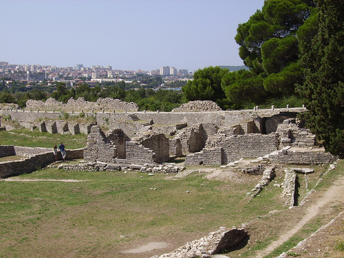
Salona is situated 5 km (3mi) from Splin on the Croatian Adriatic coast. This site is one largest and best preserved roman ruins in Croatia. Salona (in ancient Greek Σαλῶνα, Σαλῶναι, in Latin Salonae) was an ancient city of Illyria that existed during the first millennium BC. The Greeks established a colony there. After its conquest by the Romans, Salona became the capital of the Roman province of Ilírico and then, when it was divided, that of Dalmatia. The emperor Diocletian, who is believed to have been born near that place, erected a monumental palace in the vicinity in which he took refuge in his retirement. The palace, known as the Diocletian's Palace, became the nucleus of the current city of Split. Salona was largely destroyed during the invasions of the Avars and Slavic peoples, the first of them in 614. The nearby population took refuge from these attacks in the palace of Emperor Diocletian, turning it into a city. currently you can visit in the vicinity of the modern city of Solin, Croatia.
Amphitheatre
The most imposing pagan monument sits at the
western edge of the city. Built in the second half of the 2nd
century AD, the elliptical building measured about 125 by 100 m; the
arena itself was roughly 65 by 40 m. Capacity is usually given as
15,000–18,000 spectators. The northern cavea used the natural slope;
the rest stood on massive substructures with half-columns on the
outer face. A covered corridor ran around the arena. Gladiatorial
games, animal hunts, and public executions (including Christians
during Diocletian’s persecution of 304) took place here. Later the
structure was folded into the city walls. Venetians demolished large
parts in the 17th century so Ottoman forces could not use it as a
fortress. Recent conservation has reopened the 90-metre underground
corridor from the Porta Libitinae (“Gate of Death”), the passage
used to remove the dead and wounded, and has exposed original iron
clamps still holding stone blocks after nearly two millennia.
City walls and Porta Caesarea
The oldest core (Urbs vetus)
was a trapezoidal walled town already in the 2nd century BC. Under
Augustus a monumental eastern gate, Porta Caesarea, was built of
large regular blocks of local “bluestone” in opus quadratum. Two
octagonal towers flanked a triple passage: a wide central
carriageway and two narrower pedestrian side gates. Wheel ruts
(spurillae) are still visible in the paving. After the city expanded
east and west the gate lost its defensive role and carried an
aqueduct on top. Later walls (4th–6th centuries) added square then
beaked towers as Germanic and Avar pressure grew; some 90 towers
have been identified. Sections of wall remain walkable and give the
best overview of the site’s scale.
Episcopal Centre, baths,
and the late-antique city
When Christianity became official, the
civic centre shifted east of the old forum. In the 5th century a
large episcopal complex rose here: twin longitudinal basilicas (one
of them the largest in Dalmatia), an octagonal baptistery, a
Greek-cross basilica associated with Bishop Honorius, oratories, and
a bishop’s palace. Nearby stand the Great City Thermae (2nd–early
3rd century), with the usual sequence of rooms - changing rooms,
palaestra, tepidarium, caldarium - still readable in plan. Crosses
cut into doorjambs show that Christians continued to use the baths.
A recently excavated olive-oil production complex (presses, settling
tanks, storage) of the 5th–6th centuries lies east of the episcopal
centre and was probably church-owned. Two unusual intramural graves
of the 4th century (a man and a girl with jewellery and a decorated
bone comb) suggest burial inside the walls during crisis or siege.
Manastirine
Just outside the northern walls, between the main
car park and the Tusculum pavilion, lies the most important
extra-mural Christian cemetery. Early 2nd-century BC layers sit
under a 5th-century three-aisled basilica built over the graves of
martyrs, above all Bishop Domnius (Sveti Dujam), executed in 304 and
later patron of Split. Hundreds of sarcophagi once filled the area;
many carved examples are now in the Archaeological Museum in Split.
The site was already a pilgrimage destination in late antiquity.
Tusculum itself is the 1898 research house of Monsignor Frane Bulić,
the pioneer of Salonitan archaeology; it now serves as ticket office
and small display.
Kapljuč (Basilica of the Five Martyrs)
A short walk west of the main path, still outside the walls, are the
remains of Salona’s oldest cemetery basilica, mid-4th century. It
was raised over the graves of the priest Asterius and four imperial
guardsmen - Antiochianus, Gaianus, Paulinianus and Telius - killed
in the amphitheatre in April 304. The building was enlarged in the
6th century.
Marusinac
A separate cemetery complex a
little farther out contains the 4th-century mausoleum of the martyr
Anastasius of Aquileia (legend says he was thrown into the sea with
a millstone around his neck in 304) and two 5th-century basilicas.
Bishops and clergy were later buried here as well. Like Manastirine
it shows how martyr cults reshaped the city’s funerary landscape.
Other Roman infrastructure
Theatre (1st century AD), near the
poorly preserved forum; mid-sized, partly using the slope, later
robbed for church building.
Aqueduct from the Jadro springs a few
kilometres east, originally built for a smaller city but later
serving the expanded 70-plus-hectare town and, by tradition,
Diocletian’s Palace.
Five Bridges: a 1st-century BC five-arched
stone bridge over a western branch of the Jadro on the road that
continued the decumanus maximus through Porta Caesarea toward
Epetium (Stobreč) and the coast.
Western necropolis (Hortus
Metrodori) along the road to Tragurium (Trogir), still yielding rich
1st–4th-century graves, including a recent face-down burial with a
date-shaped glass balsamarium.
Visiting
The park covers
tens of hectares; allow 1.5–2.5 hours and wear decent shoes. Three
entrances exist; the main northern gate at Tusculum (Manastirine) is
the usual starting point. Adult tickets are typically around €8
(combo with the Archaeological Museum in Split available). Summer
hours are roughly 9:00–20:00; winter hours are shorter and Sunday
ticket offices can be closed. Local bus line 1 from Split (HNK /
National Theatre) stops near the site; taxi or a short drive takes
10–15 minutes. There is free parking. Bring water - there is no café
on site. The terrain is uneven; access for visitors with limited
mobility is only partial. Guided visits with museum archaeologists
can be booked in advance. Combine with Klis Fortress if you have
extra time.
Physical setting and topography
Salona occupies the Solin basin, a
gently seaward-sloping depression between two Dinaric limestone massifs:
Kozjak (779 m) immediately to the north and Mosor (1,339 m) to the east.
The basin itself is typical Dalmatian karst: low east–west limestone
ridges with marl-filled depressions between them. The ancient city
spread across this undulating but low terrain rather than sitting on a
single high acropolis. The earliest nucleus (often called urbs vetus)
had a roughly trapezoidal plan; later expansion east and west produced
an elongated, roughly elliptical defended area about 1.6 km east–west
and 0.7 km north–south.
The land slopes continuously toward the sea.
That gentle fall allowed gravity-fed water from the Jadro spring (about
33–35 m a.s.l., only a few kilometres east) to reach the city without
siphons or major bridging works. Highest points inside the ancient
circuit are around 10 m a.s.l.; the amphitheatre at the western end uses
a natural hillside on its north side and level ground on the south.
Fertile alluvial and marly soils in the basin and on the lower slopes
supported fields, vineyards, and orchards that still occupy parts of the
unexcavated ruins.
Hydrology: the Jadro
The Jadro is the
geographic key to Salona. It is a short but high-yield karst river:
source at the foot of Mosor near Klis at about 33.5 m a.s.l., length
about 4.3–4.5 km, mouth in Kaštela Bay at Solin. Discharge is highly
variable (karst springs commonly range from a few to tens of cubic
metres per second). The upper course is protected as an ichthyological
reserve for the endemic soft-mouthed trout (Salmothymus obtusirostris
salonitana). In the town the river splits into several channels and
islands (Gospin Otok and others) before reuniting near the sea; ancient
Salona used one western branch, crossed by the so-called Five Bridges.
The same spring still supplies Split, Solin, Kaštela, and Trogir. The
Roman aqueduct from the spring to Salona was about 3.85–4.9 km long
depending on the measured section, with an average bed slope around 0.36
percent. Remains of the covered channel still run along parts of the
northern wall. The river’s quality, volume, and elevation relative to
the city made the site far more viable than neighbouring coastal points
that lacked a comparable freshwater source.
Climate and
vegetation
The climate is Mediterranean: hot, dry summers and mild,
wetter winters, moderated by the sea and boxed in by the mountains.
Summer afternoons commonly exceed 30 °C; winters are rarely severe at
this elevation. Vegetation on the site and surrounding slopes is typical
coastal Dalmatian mix: maquis, cypress, olive, vine, and remnant orchard
and field plots among the ruins. The Jadro corridor is greener and more
riparian than the surrounding limestone hills.
Strategic and
regional position
Salona sits at the junction of three geographic
systems:
the Adriatic coast and Kaštela Bay (maritime trade, fishing,
a protected harbour);
the Jadro valley and fertile Solin polje
(water, agriculture);
the Klis gap, only a few kilometres north, the
historic corridor from the coast into the Dalmatian hinterland and the
Dinaric interior (Via Argentaria and other Roman roads).
Distances that still structure the landscape: about 4 km south of Klis
fortress, 6 km east of Kaštela, 22 km east of Trogir, and immediately
north of the Split peninsula. The ancient city therefore controlled both
the best harbour on this stretch of coast and the easiest land route
inland. After its destruction in the 7th century, survivors moved south
into Diocletian’s Palace; the medieval and modern settlement of Solin
grew east of the ruins along the same river, so the archaeological park
now lies west of the present town centre, between residential Solin and
the industrial/port zone toward Vranjic and Kaštela Bay.
Salona was originally a coastal stronghold and port of the
Illyrian Delmata in the immediate vicinity of Tragurion and Epetion,
colonies which in the 3rd century BC. Kr. founded by the Issei
Greeks. At that time, in addition to native Illyrians and Greek
settlers, a large number of Italians lived in Salona. During the
Roman conflicts with the Illyrians for supremacy on the eastern
Adriatic coast, in Salona in 119 BC. Kr. the Roman proconsul Lucius
Caecilius Metellus, who was nicknamed Dalmaticus because of his
victories over the Illyrians, stayed there.
After the civil
war between Caesar and Pompey, in 48 BC. Krista Salona received the
status of a Roman colony with the full title of Colonia Martia Ivlia
Salona, and became the center of Illyricum, later the province of
Dalmatia.
After the suppression of the last Illyrian
rebellion (Baton's Uprising, from the 6th to the 9th year), a period
of peace and prosperity begins for Salona, visible through urban
development and strong construction activity.
The old city
core was trapezoidal in shape, surrounded by walls and fortified
with towers, some parts of which date from the 2nd century BC.
Christ. The eastern section of the city walls built of large stone
blocks with gates bordered by octagonal towers from the time of
Augustus (Porta Caesarea) has been preserved to this day. There was
a road from them, one direction of which turned towards the
southeast and south, while the other led north towards the interior.
The rapid development of the city at the time of Augustus and
throughout the first century was accompanied by the construction of
public buildings. In the southeastern part, a forum was built with a
capitol as the center of public, political and religious life. Near
the forum, at the end of the 1st century, a theater was built that
could accommodate around 3,500 spectators. A depiction of the Salon
showing the theater is on Trajan's Column in Rome.
To the
south of the theater was an earlier built temple. Necropolises were
built outside the city walls, along the roads that led outside the
city, according to Roman custom. The most famous is the western
necropolis, called in horto Metrodori, located along the road to
Tragurion and known for the "cyclopean" construction of the fence
walls of the burial plots. From the 1st century BC The city of
Christ is expanding to the west and east, and because of the danger
from Germanic tribes, the extensions are surrounded by walls and
fortified with rectangular towers. The city takes on an elliptical
shape, the axes of which were about 1,600 meters in the east-west
direction and about 700 meters in the north-south direction.
During the construction of ramparts, individual objects become an
integral part of them for faster construction. The above-ground part
of the water supply system, which supplied the city with drinking
water from the Jadra spring already in the 1st century BC, was
incorporated into the ramparts. Christ and the most monumental
Salonitan building, the amphitheater, built in the second half of
the 2nd century in the extreme northwestern part of the city.
This Roman building, in whose arena bloody fights between
gladiators and beasts took place, could accommodate almost 19,000
spectators. In the substructures of the auditorium, two shrines of
the goddess of fate and revenge Nemesis, who was worshiped by
gladiators, were discovered. Christians later turned these
sanctuaries into memorial chapels in memory of the Christian martyrs
killed in the arena.
In the area of the eastern city
extension, parts of residential buildings and the remains of the
city insula were discovered, and southeast of Porta Caesarea, the
ruins of a luxurious villa, probably the praetorium, the palace of
the governor of the province. The floors of the palace are decorated
with multicolored mosaics depicting characters from mythology
(Apollo, Triton, Orpheus).
A large number of private and
public thermal baths were discovered in Salona. The best preserved
are the Great City Baths from the end of the 2nd century in the
eastern part of the city.
A significant period in the
development of the city was the reign of Emperor Diocletian, who
built a magnificent palace not far from Salona, where he retired
after his abdication on May 1, 305, from when the city of Split was
founded.
During his time, many monumental buildings were
built, the forum, temples and baths were restored, and the
amphitheater was added. At that time, Salona and its surroundings
had about 60,000 inhabitants, and the city had a strong cosmopolitan
spirit. In addition to the official Roman religion, various oriental
beliefs existed in Salona, such as the cults of Isis, Cybele, and
especially the widespread worship of the Asia Minor sun deity
Mithras, whose sanctuaries were found in several places within the
city.
Since the middle of the 3rd century, a Christian
community has been developing in Salona, which is linked to the work
of the first Salonitan bishop, Venantius, who came from Rome with
the task of organizing the Church in Salona and spreading
Christianity in the interior of the province. During the reign of
Emperor Diocletian (284-305), his successor, Bishop Domnius,
originally from Syria, died in the persecution of Christians in 304.
Along with him, numerous other Christians from the area of Salona
were tortured and executed, including Anastasius, the priest
Asterius and four soldiers of Diocletian's bodyguard (Antiochianus,
Gaianus, Tellius and Paulinianus).
After the Roman Emperor
Constantine issued the so-called The Edict of Milan, which allows
Christians to practice their religion freely, and one of his
successors, Emperor Theodosius the Great, declared Christianity the
only permitted religion at the end of the 4th century, greatly
changed the urban development of the city. The center of the city
was moved from the forum to the eastern part of the city, where an
episcopal center with double basilicas, a baptistery and a bishop's
palace was built at the beginning of the 5th century.
At the
beginning of the 5th century, the Bishop of Salonita became the
Metropolitan of Dalmatia, and in Salona, in 530 and 533, two
important church councils of all Dalmatian bishops were held.
After the division of the Empire in 395, the province of
Dalmatia belonged to the western part, and after the fall of the
Western Roman Empire in 476, Salona was included in the state of the
Ostrogothic king Odoacer.
Science
The first significant archaeological excavations at the Salone site,
especially the sites of the early Christian basilicas and cemeteries,
were carried out by Don Frane Bulić at the end of the 19th century. He
had the memorial collection and work area of the Archaeological Museum
built on the occasion of the First International Congress of Early
Christian Archeology held in Solin in 1894.
Other scientists such
as Fr. Luja Marun, historian Mirko Cecić and archaeologist Mihovil
Glavinić also contributed to Salona research.