Location: Klis Map
Open: Jun– Sep: 9am–7pm daily
Oct– May: 9am–5pm Sat–Sun
Cost: 10 kuna for adults
5 kuna for children
Constructed: 3rd
century BC
Klis Fortress is one of the most complete examples of
fortification architecture in Croatia. It is located in a
strategically important position in the town of Klis in the
split-damatin County, located on the pass between Kozjak on the west
side and Mosor on the east side. Due to its strategic position at
the transition from Split to Zagora and Bosnia, for centuries there
have been battles for supremacy over it. Klis Fortress is one of the
most prominent forts in Croatia, and it was first mentioned in the
5th century. for centuries, but it deserves its glory mostly from
the time of the Turkish wars, when the captain of the fortress Petar
Kružić with his uskoks resisted the attempts of the Turkish conquest
for decades, until 1537. years in the hands of the Turks. Until
then, Klis with its close surroundings remained the only free part
of the Croatian Kingdom in the south, a real enclave. Klis pass is
the most convenient point of communication between Central Dalmatian
cities and hinterland, which will gain further importance in the
time of Ottoman presence in these areas.
Klis Fortress is a
protected cultural property.
The arrival of the Croats in the Klis pass and the surrounding
hinterland of Salona was a turning point in the fortress’s long
story. Within about two centuries the ridge above the coastal plain
had become royal property and one of the political centers of the
early Croatian state. In the 9th century Klis served as a seat of
Croatian dukes and later kings of the Trpimirović dynasty. Duke
Mislav already used it as a residence around 835-845. His successor,
Duke Trpimir I (c. 845-864), founder of the dynasty, treated Klis as
his court. The Latin charter of 4 March 852, issued from “our court
which is called Clissa,” is the oldest surviving document of
Croatian rulership and names Klis as Trpimir’s property. Below the
ridge, at Rižinice, he founded a church and the first Benedictine
monastery in Croatia. Later Trpimirović rulers, including King
Tomislav, also used Klis among their principal residences. In that
sense the fortress functioned as a Croatian capital during the
formative centuries of the medieval kingdom.
After the native
Trpimirović line died out at the end of the 11th century, Klis
passed to the Hungarian-Croatian kings. They often granted it to
bans and princes. In the 1220s and again in the 1230s the powerful
Dalmatian noble Domald of Sidraga seized the fortress. Both times
the Šubić lords of Bribir took it back and restored it to the crown.
Later members of the same Šubić family, including Juraj II and
Mladen III (“the Shield of the Croats”), ruled from Klis in the 14th
century.
Its position on the narrow saddle between Kozjak and
Mosor, commanding the only practical land route from Split and Solin
into the Dalmatian hinterland and toward Bosnia, made Klis extremely
hard to storm. In the late Middle Ages and the first decades of
Ottoman expansion it became the base of the Uskoks, Croatian
frontier fighters who raided Ottoman and, at times, Venetian
territory and then withdrew into the fortress.
Captain Petar
Kružić held Klis against repeated Ottoman attacks from 1515 until
March 1537. After more than twenty years of defense he was killed
during a relief attempt near Solin. The garrison, cut off from
water, surrendered on 12 March 1537 in exchange for safe passage.
The remaining Klis Uskoks then moved to Senj, where they became the
famous Senj Uskoks. From Klis the Ottomans quickly took Solin and
pushed through the Kaštela settlements on the southern slopes of
Kozjak, but they never captured Split. They turned the fortress into
the seat of the Klis Sanjak (Kliški sandžak / Kilis Sancağı) within
the Bosnia Eyalet, a district that stretched from the Neretva toward
Drniš, Vrlika and inland Bosnia. They strengthened the walls and
built a small single-domed mosque with a minaret, traditionally
linked to the conqueror Murat-beg Tardić, on the foundations of an
earlier Croatian church. That building later became the Church of
St. Vitus (Sv. Vid).
A surprise raid on 7 April 1596 by Split
nobles Ivan Alberti and Nikola Cindro, together with Uskoks and
irregulars from Poljica and Kaštela, briefly recaptured the
fortress. Ottoman forces under Mustafa-beg recovered it the same
year. Final liberation came in March 1648, during the Cretan
(Candian) War, when Venetian general Leonardo Foscolo, supported by
Croatian captains such as the Franciscan Stjepan Sorić and Vuk
Mandušić, took Klis after a siege. The Venetians rebuilt and
enlarged the fortress for artillery warfare. They demolished the
minaret, converted the mosque into the Church of St. Vitus, and held
mass there the day after the capture. Most of the gates, bastions
(Bembo, Malipiero and others), magazines and the overall silhouette
visible today belong to the last Venetian reconstructions, later
modified by Austrian engineers in the 19th century.
The civilian
village of Klis grew after the Ottoman withdrawal. An old Turkish
fountain still stands in the settlement. The historical collection
once kept inside the fortress was later transferred to the Split
City Museum. The ridge itself remains one of the clearest layered
monuments in Dalmatia: Illyrian and Roman origins, early Croatian
royal court, Uskok stronghold, Ottoman sanjak center, and
Venetian-Austrian artillery fortress.
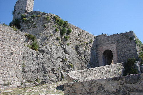
Klis Fortress sits on a narrow limestone ridge in the pass between
Kozjak and Mosor, about 12 km northeast of Split and roughly 360-385 m
above sea level. From a distance the walls almost disappear into the
rock. The ridge runs northeast-southwest; builders stacked three belts
of limestone walls on the same limestone, so the fortress reads as a
continuation of the gorge rather than a separate structure.
Three
sides are nearly impossible to assault. The only practical approach is
from the northwest. The north face drops steeply; the south side falls
away more gently. Attackers who tried to force the pass repeatedly
failed. The key gun position for anyone hoping to batter the walls was a
ridge immediately north of the fort. The ground plan is long and thin.
Later rebuilds cut through earlier layers, so the site is a stack of
periods rather than a single design.
An Illyrian stronghold of the
Dalmatae already stood here in antiquity, probably from the 3rd or 2nd
century BC. Romans used the pass as a corridor between Salona and the
hinterland. Early Croatian dukes made Klis a royal seat. Duke Trpimir I
held it in the 9th century; a church of St. Vitus is attested in the
early medieval period. Most of what visitors walk through today comes
from Venetian and Austrian modernization. During Ottoman rule the walls
themselves were not rebuilt on a large scale. The main Ottoman remains
are the mosque (now the Church of St. Vitus) and the fountain at the
foot of the rock.
Ottoman period
Whoever held Klis controlled
trade between Split, the main port for central Bosnia, and the inland
route toward Sinj and Bosnia. That mattered to both Venice and the
Ottoman Empire. The fortress’s most famous chapter is the 16th century.
Captain Petar Kružić held it from 1520 until 1537 and beat back dozens
of Ottoman attacks - tradition speaks of about fifty incursions - before
he was killed during a relief attempt. The fortress fell in March 1537
to forces under Murat-beg Tardić.
Under the Ottomans Klis became one
of the strongest posts on the western frontier of the empire. It worked
with three smaller works nearby: Donje or Lončarić (Gradina in Solin),
Vrankovci (likely Vrankuk in Ozrna), and Kozjak. Many local Christians
left for Senj and the central Dalmatian islands. Muslim settlers arrived
in stages: first Asker (soldiers), later craftsmen, merchants, and
farmers. Life on the pass continued, especially trade. Ottoman tax
registers (defters) list many villages as mezra - abandoned or
half-empty sites with traces of older settlement.
The suburb lay on
the western side of the fortress. In the 1574 defter the Klis suburb is
a market town with a mostly Christian population. By 1604 it is a
kasaba, a trading post with a Muslim majority. Place names still mark
that period: Varoš and Megdan at the western foot of the rock. The
Ottomans held Klis for 111 years. A brief Croatian and Uskok recapture
in 1596 did not last. Venice took the fortress in 1648 during the War of
Candia under Leonardo Foscolo, then rebuilt gates, bastions, magazines,
and barracks. Austria inherited the site after 1797 and altered portals
and barracks in the 19th century.
Mosque / Church of St. Vitus
The mosque stands inside the third defensive wall, between the Venetian
Bembo and Malipiero bastions. It has a small square plan because it
served only the garrison. It was built soon after the fall of 1537 and
named for Murat-beg Tardić, the conqueror of Klis. Research has shown an
earlier medieval church of St. Mary on the same spot.
The building is
rough stone under a dome. The transition from square plan to circular
dome uses a double drum: first an octagon with four trompe squinches,
then a ring drum. The trompes carry reduced muqarnas, the typical
Islamic honeycomb used on vaults and squinches. When the Venetians
turned the mosque into a church they left the muqarnas in place. They
walled up the old entrance, opened a new door on the southwest side to
change the liturgical orientation, and demolished the minaret on the
west. A quartermaster building for Venetian officers rose there; only
the minaret foundations survive. An inscription above the present
entrance reads, in spirit: “What piety builds, piety also preserves.”
The structure is modest, which fits a garrison chapel packed inside a
fortress. After 1648 it became the Church of St. Vitus (Crkva sv. Vida).
A Baroque stone baptismal font dated 1658 remains. Recent restoration
has stabilized the building. It is one of the rare surviving pieces of
Ottoman architecture on the Dalmatian coast.
Fountain (çeşme)
At the foot of the fort, between the ridge and the gorge, a stone
fountain is still in use. Locals call it the Three Kings. A 17th-century
view by Eraut already labels it Fontana dei Tre Regi. The cistern has an
open porch and pointed oriental arches. It belongs to the mihrab çeşme
type: a fountain with a niche. Similar Turkish taps survive elsewhere in
Croatia, and many still work.
Water was both a religious and a
military necessity. Islamic law requires ablution before prayer; fiqh
texts distinguish several grades of water and impurity. In a long siege,
loss of water usually forced surrender. Besides this fountain, the
garrison used several cisterns cut as needed inside the walls.
Flora
The same ridge that made Klis hard to take also creates two
microclimates a few dozen meters apart. The sunny south face is
Mediterranean; the north face is cooler and can hold snow. Surveys list
more than 300 plant species around the fortress and cliffs, including 16
endemics and about 20 strictly protected species. Among them are
Adriatic fibigia (Fibigia triquetra, first identified here and now a
local emblem), Dalmatian sharp-leaved and yellow-leaved taxa from the
source list, Dalmatian fleabane, medicinal sage, pyramidal bellflower,
Dalmatian iris (perunika), and blue hazel. Sage, figs, almonds, olives,
and wild asparagus still belong to everyday Dalmatian use.
Visiting notes
The walk runs through three gates: an Austrian first
gate of the 1820s, a second gate on the medieval western approach, and a
third gate into the oldest core, last recast by Venice in 1763. A small
museum in a former armory shows weapons, armor, and Uskok dress. Views
take in Split, the Kaštela coast, and the islands. The site was used as
Meereen in Game of Thrones. Combined tickets with the Interpretation
Centre at Megdan and Stella Croatica are sold on site; official hours
are often listed as 8:30-20:30 in season, with adult tickets around €12.
Bus line 22 from Split stops at Klis Megdan. Summer heat on bare
limestone is severe, so morning visits work better.