Location: Morbihan department
Map
Constructed: 3300- 4500 BC
Official
site
Musee de Prehistoire
10 place de la Chapelle
Tel. 02 97 52 22 04
Open: Wed- Mon
Closed: January 1, May 1, December 25
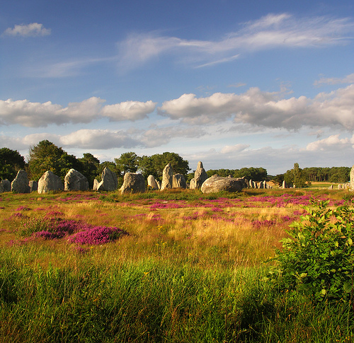
The Carnac Stones (Breton: Steudadoù Karnag), also known as the Carnac Alignments, form one of the world's largest and most enigmatic collections of prehistoric megalithic monuments. Located near the village of Carnac in the Morbihan department of southern Brittany, northwestern France, they represent an exceptionally dense concentration of Neolithic structures along the Atlantic coast, between the Quiberon peninsula and the Gulf of Morbihan.
A Brief Overview
The site features thousands of granite stones
arranged in rows (alignments) stretching several kilometers, along with
individual menhirs, stone circles (cromlechs), and burial structures.
The main alignments are Le Ménec, Kermario, and Kerlescan. These are
among the largest concentrations of megaliths anywhere.
The purpose
remains a mystery—possible astronomical calendars, processional routes,
or social/ritual markers—but they represent remarkable prehistoric
engineering. In 2025, many megalithic sites in the area, including
Carnac, were inscribed as a UNESCO World Heritage Site.
Pronunciation: French "kar-nak"; Breton "kar-nag."
Best Time to
Visit
October to March: Free public access to some alignments (you
can often walk among the stones, weather permitting). Fewer crowds,
atmospheric light, but shorter days and potentially cold/wet weather.
April to September: Restricted access—guided tours only inside fenced
areas to protect the site. High season (July–August) is busiest; visit
early morning or late afternoon for better light and fewer people.
Ideal periods: Late spring (May–June) or early fall (September–October)
for pleasant weather, good lighting for photos, and manageable crowds.
Winter offers a mystical feel with dramatic skies, while summer pairs
well with beach time.
How to Get There
By car (easiest): About
1.5 hours from Nantes or Rennes. Park at the Maison des Mégalithes (P4
alignments car park) or other designated spots. Campervans have specific
parking (e.g., Kerabus).
Public transport: Train to Auray, then bus
or taxi. Limited options—car or bike is preferable for flexibility.
Local exploration: Many sites are walkable or bikeable from Carnac town.
Rent bikes for scenic coastal paths.
Practical Visiting Tips
Access Rules:
Free footpaths around the fenced alignments year-round
for exterior views.
Inside the main alignments: Guided tours required
April–September. In winter, some areas open for free wandering (check
conditions).
Stay on marked paths — do not touch, lean on, or climb
stones. They are fragile and protected.
Dogs on leads allowed on
paths (not on guided tours or in buildings).
Closed shoes
recommended; terrain can be uneven. Pushchairs/strollers not ideal.
No smoking on site.
Guided Tours:
Book at the Maison des
Mégalithes (visitor center at Le Ménec) or online via
monuments-nationaux.fr. Tours last ~1 hour.
Adult ticket: ~13€
(reduced rates available). English tours sometimes in peak season.
Little tourist trains with audio guides also operate—good for families
or mobility needs.
Visitor Center (Maison des Mégalithes):
Excellent starting point with exhibits, films, shop, and rooftop viewing
platform for aerial perspectives of the alignments.
Opening hours
vary seasonally (e.g., 9:30am–7pm in peak summer; closed Jan 1, May 1,
Dec 25).
Carnac Prehistory Museum (Musée de Préhistoire):
Highly recommended—houses thousands of artifacts from local sites. Start
here for context on Neolithic life, tools, and burial practices.
Self-guided; some English info and summer guided tours.
Megalithic Pass (Pass Mégalithes)
Great value if visiting multiple
sites. Get it at your first participating site for discounts on
subsequent ones. Includes:
Carnac Alignments
Carnac Prehistory
Museum
Locmariaquer megalithic sites
Gavrinis cairn (boat access)
Petit-Mont cairn
This encourages deeper exploration of the Gulf of
Morbihan’s rich prehistoric landscape.
Nearby Attractions & Day
Trips
Locmariaquer: Giant broken menhir, Table des Marchands.
Gavrinis: Stunning decorated passage tomb (boat trip from Larmor-Baden).
Beaches in Carnac-Plage for relaxation.
Other local menhirs, dolmens,
and coastal walks.
Quiberon Peninsula or Vannes for broader Brittany
charm.
Other Options: Segway tours, private guided tours, or evening
light shows (Skedanoz) in summer.
What to Bring & Other Tips
Binoculars for distant views.
Weather-appropriate layers (Brittany
weather changes quickly).
Picnic supplies—beautiful spots for lunch.
Cash/credit cards for tickets.
Respect the site: No littering, stay
on paths.
For mobility: Some paths are accessible; check ahead.
Driving the D196 offers good roadside views.
Combine with Breton
cuisine (seafood, crêpes, cider) in town.
Construction and Dating
The stones were erected during the
Neolithic period (roughly 5000–2300 BCE), marking the transition to
farming societies in Western Europe. Recent radiocarbon dating from
sites like Le Plasker (a newly identified section) places some
alignments between ~4600–4300 BCE, potentially making Carnac and the Bay
of Morbihan home to Europe's earliest known megalithic
monuments—predating Stonehenge by about 1,000 years.
Earlier
estimates ranged from ~4500–3300 BCE. Construction involved quarrying
local granite, transporting (likely using rollers, levers, and brute
force), and erecting stones weighing several tons each. The scale
implies sophisticated social organization, possibly under elite leaders
or "divine kings," as suggested by rich grave goods and monumental
effort.
The broader "Megaliths of Carnac and the shores of Morbihan"
serial UNESCO property (inscribed 2025, criteria i and iv) encompasses
four components across ~550 monuments in 27 communes, highlighting over
2,000 years of successive building tied to the landscape's topography
and hydrography.
History of Discovery, Excavation, and Management
Early Interest: Descriptions date back to the 18th century (e.g., Comte
de Caylus). Legends and folklore proliferated earlier.
19th Century:
Scottish antiquary James Miln conducted major excavations in the
1860s–1870s, noting that many stones had fallen or been removed for
building/roads. His assistant, local Zacharie Le Rouzic, continued the
work into the 20th century, restoring stones and establishing the Museum
of Prehistory in Carnac.
20th–21st Centuries: State protection as
historic monuments began in the late 19th century. Restorations
straightened stones. Access restrictions were introduced in the 1990s
due to tourism damage; free access is now limited (e.g., winter). In
2025, UNESCO inscription provided further recognition and protection.
Challenges include past dismantling for agriculture/roads, modern
development pressures, and erosion. Some stones outside protected zones
were controversially destroyed as recently as 2023 for construction.
Legends and Folklore
Christian legend attributes the stones to
Saint Cornély (patron of cattle), who turned pursuing Roman soldiers to
stone. Arthurian tales link them to Merlin. Local Breton stories involve
Korrigans (goblins) or animated stones. These myths helped preserve awe
around the site before scientific understanding.
Theories on
Purpose
The exact purpose remains one of archaeology's great
mysteries—no consensus exists. Prominent ideas include:
Astronomical/Calendar: Alignments possibly tracking solstices, lunar
cycles, or celestial events (e.g., Alexander Thom's surveys and
"megalithic yard" concept, though debated).
Ceremonial/Religious:
Processional ways, ritual borders between land/sea or living/dead
worlds, or sites for ancestor worship. Engravings (axes, serpents,
abstract symbols) suggest symbolic or power-related meanings.
Burial/Social: Linked to elite tombs; alignments may mark territories or
commemorate lineages.
Other: Territorial markers, seismic
early-warning (speculative), or expressions of social cohesion in
emerging agricultural societies.
The site's evolution over
millennia— with later structures reusing earlier stones—indicates
ongoing cultural significance.
Significance
Carnac offers
profound insights into Neolithic technological skill, long-distance
trade, social hierarchy, and ideological shifts during Europe's adoption
of agriculture. Its density, diversity, and landscape integration make
it exceptional. As a UNESCO site, it underscores humanity's early
monumental architecture and symbolic engagement with the environment.
Overall Layout and Scale
The site stretches over several
kilometers along a coastal ridge (roughly following a contour line ~20
meters above sea level), integrating alignments with the natural
topography—ridges, slopes, and proximity to the sea. The stones are not
randomly placed but show deliberate organization in relation to terrain,
intervisibility between monuments, and possibly astronomical or symbolic
orientations.
Total stones: Over 3,000 standing menhirs (upright
stones) in the main alignments, part of a wider regional total of
thousands more menhirs, dolmens, tumuli, and other features. The
alignments themselves extend nearly 4 km.
Main alignments (from west
to east): Ménec, Kermario, Kerlescan, and the smaller Petit-Ménec. These
may originally have been more continuous but were disrupted by later
removals for building materials.
Key characteristics of the
architecture:
Stones decrease and then increase in height along rows,
creating a dynamic, wave-like or fan-like visual effect that follows the
landscape’s relief.
Alignments often terminate in cromlechs (stone
circles or enclosures).
The overall layout integrates linear rows
with circular/quadrangular elements and is tied to burial monuments
(tumuli and dolmens).
The Major Alignments
1. Ménec Alignments
(westernmost, most famous):
11 converging rows.
Length: ~1,165 m;
width: ~100 m.
~1,100 stones.
Western end: Larger stones (~4 m
high) and a cromlech (stone circle) with ~71 stones.
Stones gradually
diminish in size eastward, then grow again.
Eastern end: Ruined
cromlech.
2. Kermario Alignments (“House of the Dead”):
10
columns, ~1,029 stones.
Length: ~1,300 m.
Fan-like layout similar
to Ménec.
Stones shorter at the eastern end, with a stone circle
revealed by aerial photography.
3. Kerlescan Alignments:
13
lines, 555 stones.
Length: ~800 m.
Heights: 0.8–4 m.
Western
end: Stone circle with 39 stones (another possible one to the north).
4. Petit-Ménec: Smaller, wooded group further east.
Other
features include the Manio Quadrilateral (a large rectangular enclosure)
and the Giant of Manio (a single massive menhir over 6.5 m tall).
Materials and Construction Techniques
Material: Local weathered
granite from nearby outcrops/bedrock. No long-distance quarrying for
most stones.
Sizes: Range from ~0.5 m to over 6–7 m tall. Average
menhirs weigh 5–10 tonnes; larger ones much more.
Methods: Stones
were likely levered, rolled on logs/rollers, and erected using ropes,
pulleys, and earthen ramps (earth piled to the height of the stone, then
removed). Placement involved precise alignment, often with stones
oriented or shaped for visual effect.
Precision: Rows are remarkably
straight or gently curving to follow topography. Heights are graduated
deliberately. This required significant social organization, labor, and
planning—evidence of coordinated Neolithic communities (possibly with
elite leadership).
Associated structures include:
Tumuli
(earthen mounds over chambers): e.g., Saint-Michel (huge, ~125x60 m
base, 12 m high, with rich burials including jade axes and callaïs
jewelry from distant sources).
Dolmens (passage tombs): Table-like
structures with capstones, some with carvings (e.g., axes, serpents).
Purpose and Interpretation
The exact purpose remains enigmatic—no
definitive consensus exists. Theories include:
Astronomical
observatory/calendar: Alignments possibly tracking solstices, lunar
cycles, or stars (studied by Alexander Thom).
Ceremonial/ritual
processional ways: Marking sacred paths, boundaries between land/sea or
living/dead worlds.
Burial/ancestral landscape: Linked to elite tombs
and funerary practices.
Social/political: Demonstrating power,
territory, or communal effort under “divine kings” or elites (supported
by exotic grave goods like Alpine jade).
The architecture reflects
sophisticated environmental integration—monuments positioned for
visibility, topography, and possibly symbolic cosmology—marking a
transition in human-landscape interaction during the Neolithic.
Preservation and Access
Many alignments are fenced for protection
(vegetation recovery, erosion control), with guided tours available. The
Maison des Mégalithes visitor center provides context. Sheep grazing
helps manage vegetation. Despite some historical losses (stones reused
for building), the site is now well-protected as a historic monument and
UNESCO site.