Location: Brittany Map
Saint-Malo, a historic port city in Brittany (Ille-et-Vilaine department), France, is renowned for its dramatic coastal setting, formidable granite fortifications, and rich maritime heritage as a "Cité Corsaire" (Corsair City). It was a hub for explorers (like Jacques Cartier, who claimed Canada for France), privateers, and sailors. Much of the old town was heavily damaged in WWII but meticulously rebuilt, preserving its medieval character.
1. Intra-Muros (The Walled City)
The heart of Saint-Malo is
the Intra-Muros ("within the walls"), a densely packed historic
district enclosed by massive ramparts. This fortified peninsula juts
into the English Channel, creating a striking silhouette of granite
buildings with slate roofs against the sea.
Atmosphere and
architecture: Narrow cobblestone streets, colorful shops, crêperies,
seafood restaurants, and historic houses. It feels like stepping
back into a pirate-era town, with lively squares and hidden alleys.
History: Origins trace to a monastic settlement in the 6th–12th
centuries. It thrived as a trading and privateering port from the
16th–18th centuries. Almost entirely destroyed by Allied bombing in
1944, it was rebuilt stone-by-stone over about 12 years (1948–1960)
to match the original layout and style.
Highlights inside:
Boutiques, the main square (Place Chateaubriand), and easy access to
the ramparts and beaches.
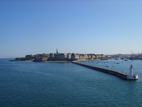
2. Les Remparts de Saint-Malo (The
Ramparts)
One of the most iconic features and a must-do activity.
These granite walls encircle Intra-Muros for about 2 km, offering
panoramic sea views, beach vistas, and overlooks of the city
rooftops.
Construction: Parts date to the 12th century, with
major expansions in the 17th–18th centuries by engineers like
Garangeau (influenced by Vauban). Includes towers, bastions,
machicolations, and gates.
Experience: A flat, walkable loop
(about 1 hour). Best at sunrise, sunset, or during high tide for
dramatic waves crashing against the walls. Key points include the
Bidouane Tower (largest and most seaward-facing) and views toward
nearby forts.
Views: Overlook Grande Plage du Sillon, the port,
and tidal islands.
3. Château de Saint-Malo
Located at the
northeast corner of Intra-Muros, this castle was built by the Dukes
of Brittany in the 15th century and later used by French royalty.
Features: Impressive keep (1424), Quic-en-Groigne Tower, and other
towers. It now houses the Musée d’Histoire de la Ville (city history
museum) with exhibits on maritime history, privateers, and local
artifacts, plus the town hall.
Significance: Symbol of the city's
defensive and ducal past. Offers great views from its towers.
4. Cathédrale Saint-Vincent (Saint-Vincent Cathedral)
A
central landmark inside Intra-Muros, with origins in the 12th
century (Romanesque-Gothic style).
Interior: Features stunning
modern stained-glass windows that create beautiful light effects, a
mix of architectural styles from rebuilds, and historical elements
tied to the city's religious and seafaring past.
Role: A focal
point for the community and visitors; its spire is visible from
afar.
5. Fort National
A standout offshore fortress built
in 1689 by Vauban and Garangeau to defend against the British.
Access: Reachable on foot at low tide (check tide times—it's
dangerous otherwise).
Highlights: Impressive granite structure
with battlements, cannons, and views back to the city. Guided tours
available; it hosted prisoners historically.
Appeal: Combines
military history with scenic coastal walks. Nearby is the smaller
Petit Bé fort (also by Vauban).
6. Grand Bé Island and
Chateaubriand’s Tomb
A tidal island accessible at low tide near
Bon Secours beach. French Romantic writer François-René de
Chateaubriand (born in Saint-Malo) is buried here, facing the sea as
he requested.
Significance: A peaceful, literary pilgrimage site.
The tomb is simple and evocative, surrounded by dramatic coastal
scenery.
Nearby: Petit Bé and other rocky outcrops enhance the
wild, tidal character of the area.
7. Beaches and Coastal
Areas
Saint-Malo boasts beautiful sandy beaches right against the
walls, a major draw beyond the historic core.
Grande Plage du
Sillon: The longest and most popular, great for walks, swimming
(when safe), and people-watching.
Other spots: Plage de Bon
Secours (near Grand Bé, with a seawater pool), and areas for sailing
or observing extreme tides (one of Europe's largest tidal ranges).
Vibe: Family-friendly in summer, with promenades, water sports, and
views of the ramparts.
8. Other Notable Sites
Demeure du
Corsaire (Corsair’s House / Hôtel Magon): 18th-century mansion of a
shipowner-privateer. One of the best-preserved original buildings,
now a museum highlighting the golden age of corsairs.
Grand
Aquarium: Modern attraction with large tanks, sharks, and
interactive exhibits—popular with families.
Port and Môle des
Noires: Working harbor with ferries (e.g., to Dinard or the UK),
lighthouses, and maritime activity.
By plane
The nearest airports are in Dinard and Rennes.
By
train
The Saint-Malo Train Station is about 1 km from the walled old
town (intramuros). The bus station is located directly in front of the
train station. The old Town can also be reached in about 20 minutes on
foot along Avenue Luis Martin, heading west.
TGV from
Paris-Montparnasse to Saint Malo (about 3h)
TGV and TER (regional
train) from Rennes (about 50 minutes travel time). Depending on the time
of day, up to 2 trains per hour.
By bus
Long-distance buses go
to Rennes, from there by train.
On the street
Motorway A11,
exit Paris, then N 137; A84
Cheap parking to visit the historic
old town "ville close": Paul Féval. Located at the Hippodrome.
Signposted on the main roads as "P+R". From there, shuttle bus
("Navette") every quarter of an hour (during the day) to the entrance of
the ville close: Esplanade Saint Vincent. Bus destination "intra muros".
Parking fee incl. Shuttle bus fee: € 3.30 (as of August 2018)
By
boat
Naye Ferry Terminal (Ferry port)
Daily trips between
Saint Malo and Portsmouth, Poole, Jersey and Guernsey.
From April in
the summer months, the compagnie Corsaire bus departs from Dinard
approximately every 40 minutes, return fare: € 8.20, in July/Aug. 8,80 €
(2022), a good 10 minutes driving time. The branch is Intra Muros at the
southern end of Rue Dinan, reachable by buses 8 and 11.
Call Taxi (24 hrs): Allo Taxi Tel: 02 99 81 30 30
Busses
Saint-Malo has a well-developed low-cost bus system with Malo Agglo
Transports (MAT). It reaches as far east as Cancale. The central bus
station is located at the railway station. The bus stop "Intra Muros" is
located directly at the entrance of the old Town at the tourist office.
Connections to Dinard, Saint-Lunaire and Saint-Briac (line 16) are
provided by the bus company BrezhGo. You can also get to Dinard by bus
du mer.
The frequency of lines 1, 2 and 3 is 15 minutes during
the day on weekdays, that of lines 4 to 6 is half an hour and that of
lines 7 and 8 is once an hour. Line numbers 10 to 15 serve the
surrounding villages ("périrbains") on Saturdays and in the evening the
frequency is halved, on Sundays again. Some lines do not run at all.
Only in summer line 9 rattles off all the beaches.
Payment is to
be made with a value card, which is held to the reader at the time of
entry. The single trip (90 min.) costs € 1.35 or € 12.00 when buying a
ten-ticket. If you pay the driver, you will also get one, but in 2022
you will pay a little more for the single trip with € 2. Day tickets (24
hours) are available for €3.90 (€ 5 for the driver). As a group ticket
(up to 5 pers.) these are available at the price of € 12/24 h, or €
20/48 h. Prices (as of: Jun 2022).
Ancient and Early Medieval Origins (1st Century BC – 8th Century AD)
The area around Saint-Malo has deep roots. In the 1st century BC, Gauls
founded a settlement nearby, known to the Romans as Reginca or Aletum
(modern Saint-Servan). By the late Roman period, a major Saxon Shore
fort protected the Rance estuary from raiders.
After the Western
Roman Empire's decline, Celtic Britons (including monks) fled
Anglo-Saxon invasions in Britain and settled in Armorica (Brittany). In
the 6th century, Welsh monk Saint Malo (or Maclou/Maclovius), a follower
of Saint Brendan the Navigator, established a monastic settlement on a
rocky islet (originally Aaron's Rock). This became the namesake of the
town. Another monk, Saint Aaron, also played a role in early settlement.
The island provided refuge, and the bishopric later transferred there.
The islet was not heavily populated until the 8th century, when locals
sought protection from Norman (Viking) raids. This defensive, insular
character shaped the city's identity.
Medieval Growth and
Fortification (12th–15th Centuries)
In the 12th century, urbanization
accelerated. Bishop Jean de Châtillon transferred the episcopal see from
Aleth to the islet in 1144–1152, boosting development. The town gained
rights of asylum, attracting diverse populations (including
adventurers). Ramparts began forming, and the city expanded on its rocky
promontory.
Saint-Malo asserted autonomy against French and Breton
authorities. It became a free commune (1308) and later a free port
(1395), fostering trade and shipbuilding. The Château de Saint-Malo
(with towers from the 14th–17th centuries) and cathedral of
Saint-Vincent (parts from the 12th century) date to this era.
Golden Age of Corsairs and Independence (16th–18th Centuries)
Saint-Malo's maritime prowess peaked in the 16th–18th centuries. Its
strategic location at the mouth of the Rance made it ideal for trade,
fishing (especially cod from Newfoundland, terre-neuvas), and raiding.
Corsairs (privateers) — state-sanctioned raiders with letters of marque
from the French king — were central. Unlike pirates, they targeted enemy
ships (especially English) during wartime, sharing spoils with the
crown. Famous figures include:
Jacques Cartier (1491–1557): Explorer
who claimed Canada for France, sailing from Saint-Malo.
René
Duguay-Trouin (1673–1736): Captured Rio de Janeiro in 1711.
Robert
Surcouf (1773–1827): "King of Corsairs," who seized dozens of ships,
including valuable East Indiamen.
Wealth from privateering,
transatlantic trade, and shipowning built grand mansions. Between
1688–1713, Malouin corsairs seized over 4,000 vessels. The city briefly
declared itself an independent republic (1590–1594) during religious
wars, adopting the motto "Ni Français, ni Breton, Malouin suis"
("Neither French nor Breton, but Malouin am I").
This era linked to
global events: the Falkland Islands (Îles Malouines) were named after
Malouins by explorer Louis-Antoine de Bougainville. Writer François-René
de Chateaubriand (born 1768) also hailed from here.
19th Century
to World War II
After the French Revolution and Napoleonic Wars,
privateering declined (formally abolished in 1856). Saint-Malo shifted
to fishing, trade, and tourism. It remained a vibrant port but faced
economic challenges.
In 1940, Nazi Germany occupied Saint-Malo as
part of the Atlantic Wall. It became a fortified stronghold with
bunkers, artillery, and a large garrison (including remnants of the 77th
Infantry Division and Eastern battalions).
World War II:
Destruction (1944)
The Battle of Saint-Malo (August–September 1944)
was part of the Allied breakout from Normandy into Brittany. U.S. forces
(mainly 83rd Infantry Division under VIII Corps) aimed to secure the
port. Germans, commanded by Colonel Andreas von Aulock, defended
fiercely from fortified positions, including the Citadel (Fort de la
Cité d'Aleth), ramparts, and offshore Cézembre island.
Allied bombing
and shelling (starting early August) devastated the city. A fire raged;
civilians evacuated under truce. The walled city was nearly
obliterated—about 80% of buildings inside the ramparts destroyed (over
680 structures), with the cathedral heavily damaged. The Citadel fell on
August 17; Cézembre surrendered September 2 after running out of water.
Over 10,000 Germans were captured. German demolitions rendered the port
unusable.
Post-War Reconstruction and Modern Era (1940s–Present)
Reconstruction began in 1947–1948 under architect Marc Brillaud de
Laujardière. Rubble clearance took years; rebuilding (1948–1960, with
cathedral spire in 1971) used original stones where possible, faithfully
restoring the medieval street layout, ramparts, and granite character.
Many consider it a remarkable success, though some note simplified
details in rebuilding.
In 1967, Saint-Malo merged with Saint-Servan
and Paramé, expanding the commune. Today, it thrives on tourism
(ramparts walks, beaches, aquarium, corsair history museums), ferries to
the Channel Islands, yachting (e.g., Route du Rhum race), and its
historic charm. Population is around 47,000 (commune), swelling in
summer.
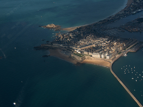
Location and Regional Context
Coordinates: Approximately
48°38′58″N 2°01′34″W.
It lies on the northern coast of Brittany, near
the border with Normandy, about 400 km west of Paris.
The city faces
the Channel Islands (Jersey and Guernsey) across the water and is
strategically positioned at the southwestern edge of the English
Channel.
The broader Gulf of Saint-Malo (Golfe de Saint-Malo)
encompasses the area between the Brittany Peninsula, Normandy’s Cotentin
Peninsula, and the Channel Islands. It includes notable features like
the Bay of Mont-Saint-Michel.
Topography and Physical Features
Saint-Malo’s geography is defined by its dramatic coastal setting on a
rocky granite formation:
The historic Intra-Muros (walled city)
originally stood on a granite islet connected to the mainland by a
causeway and later by a bridge/avenue. Over time, urban expansion and
land reclamation have made it feel more integrated with the mainland,
though it retains its peninsula-like character.
Elevation: Ranges
from sea level to about 51 m (average ~8 m), with modest variations in
the immediate area. The terrain is relatively flat to gently rolling
near the coast but features rocky outcrops, cliffs, and islets.
Coastline: Characterized by granite rocks, sandy beaches, and tidal
flats. Key nearby features include the Pointe de la Varde natural park,
Fort National (accessible at low tide), and small islands like Grand Bé
and Petit Bé.
The city has expanded through mergers with neighboring
communes (Saint-Servan and Paramé in 1967), creating a larger urban area
with beaches like Sillon Beach, Bon-Secours (with a tidal pool), and
others along the Emerald Coast (Côte d’Émeraude).
The Rance River
estuary plays a major role, with the city on its right bank. A tidal
power plant (barrage) on the Rance harnesses the extreme tidal range.
Tides and Marine Environment
One of Saint-Malo’s most defining
geographic traits is its extreme tidal range—among the highest in
Europe:
Regular tides reach 7–8 meters (23–26 ft); spring tides
(especially around equinoxes) can exceed 12–14 meters (up to ~49 ft in
extreme cases).
This creates dramatic daily transformations: at high
tide, the sea crashes against the ramparts; at low tide, vast sandy
expanses and mudflats are exposed, allowing walks to offshore forts and
islands.
The area is influenced by the Gulf Stream, which
moderates temperatures, and strong Atlantic currents. The coast
experiences significant wave action, storms, and occasional flooding
risks, leading to robust sea defenses like breakwaters and the historic
ramparts.
Climate
Saint-Malo has a classic oceanic temperate
climate (Cfb in Köppen classification), heavily moderated by the
Atlantic:
Mild temperatures: Winters are relatively warm (average
January ~6–7°C), summers cool (August ~17–18°C). Annual average around
11–12°C. Extreme highs rarely exceed 30°C; lows seldom drop below
freezing.
Precipitation: Frequent rain (especially autumn/winter),
around 700–800 mm annually, spread over many days. Windy conditions are
common.
Sea temperatures: Range from ~9°C in winter to ~18°C in
summer.
The Gulf Stream softens the climate compared to inland areas,
resulting in low seasonal temperature variation and lush vegetation.
Human and Historical Geography
The geography shaped Saint-Malo’s
history as a seafaring and defensive stronghold. The granite islet
provided natural protection, enhanced by massive 12th–18th century
ramparts (nearly 2 km long) that still encircle the Intra-Muros. These
walls, along with forts like the Château de Saint-Malo, were built to
withstand sieges and the sea.
The port remains active for ferries (to
the UK and Channel Islands), fishing, and yachting. The city is a major
tourist hub, with population swelling from ~47,000 residents to hundreds
of thousands in summer.