Location: Hunedoara County Map
Area: 38 hectares (94 acres)
Elevation: 2482 m
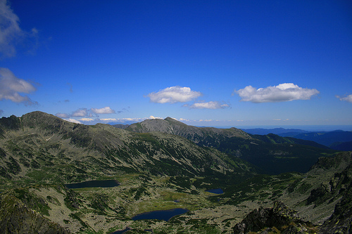
Retezat National Park, located in the Retezat Mountains of Hunedoara County in southwestern Romania, is the country's oldest national park, established in 1935. Spanning 380.47 square kilometers (94,020 acres), it protects some of Europe's last remaining intact old-growth forests and the largest single area of pristine mixed forest on the continent. Known as the "blue-eyed land" for its over 80 glacial lakes, the park features dramatic granite massifs, more than 60 peaks exceeding 2,300 meters, and exceptional biodiversity. It is a UNESCO Biosphere Reserve since 1979, an IUCN Category II protected area, and holds the European Diploma of Protected Areas. The park's coordinates are approximately 45°20′N 22°50′E, with the nearest town being Lupeni. It attracts hikers, wildlife enthusiasts, and eco-tourists seeking unspoiled wilderness in the Southern Carpathians.
Scientific interest in Retezat's flora dates back to the early 19th century. In the 1930s, botanist Alexandru Borza and biologist Emil Racoviță advocated for nature reserves in Romania. The Tătărescu government designated 100 square kilometers of the Retezat Mountains as a national park in 1935, with formal legislation following in 1939, setting a precedent for future protected areas. Initially, part of the area was royal hunting grounds. In 1979, UNESCO included it in the Man and the Biosphere Programme. The 1990s saw increased threats from logging and sheep grazing, prompting ecological restoration efforts in the 21st century. A 2006 land restitution to the Kendeffy family heirs, claiming 10,000 hectares, was overturned in 2022, restoring state ownership. The park was formally re-established under Law No. 5 in 2000.
Retezat's geology features two major granodioritic massifs: the
northern Retezat type and the southern Buta type, separated by
crystalline schists and interspersed with Paleozoic and Mesozoic
sediments, including Jurassic and Cretaceous limestones. This creates a
rugged landscape with high relief energy, steep slopes up to 60 degrees,
and karst features like gorges, plateaus, dolines, and over 200 caves
rich in stalactites and cave fauna. Quaternary glaciation sculpted over
58 permanent glacial lakes (some sources cite over 80), glacial valleys,
cirques, moraines, and striated rocks. The highest peak, Peleaga at
2,509 meters, anchors the northern crest, with secondary crests
branching out.
The climate is humid, with high precipitation due to
oceanic air masses, leading to maximum river drainage in spring from
snowmelt. Hydrology includes a dense network of rivers draining to the
Strei and West Jiu basins, with waterfalls on nearly every brook and
anthropogenic features like the Gura Apei reservoir. Soils vary by
altitude, dominated by acid podsols in crystalline areas and alkaline
rendzinas in calcareous zones. Landslides from heavy rains, like the
1999 event, periodically reshape valleys.
The park's biodiversity is exceptional, with about 1,190 plant
species—over a third of Romania's flora—including 90 endemics and 130
endangered or vulnerable species. Habitats range from old-growth beech,
spruce, and fir forests (covering 49% of the park) to subalpine meadows
with mountain pine, juniper, and rhododendrons, and alpine grasslands
featuring gentians and edelweiss. The Gemenele scientific reserve
protects 1,800 hectares of pristine mixed forest.
Fauna includes 55
mammal species (over 23% of Europe's terrestrial mammals), such as brown
bears, wolves, lynx, chamois, red deer, roe deer, wild boars, otters,
and Alpine marmots (introduced in 1973). Over 120 bird species nest
here, including golden eagles, peregrine falcons, black grouse, and
western capercaillies, making it an Important Bird Area. Invertebrates
feature over 1,100 butterfly species across two Prime Butterfly Areas,
plus 8 fish, 5 reptile, and 7 amphibian species. The park is a key
conservation site for large carnivores and bats (13 species).
Highlights include Peleaga Peak (panoramic views), Retezat Peak
(2,482 meters, with its "cut" summit), and lakes like Bucura (largest at
8.8 hectares), Zănoaga (deepest at 29 meters), and clusters such as Ana,
Lia, and Florica. Waterfalls (e.g., Lolaia, 15 meters), gorges
(Scorota), and cirques (Galeșul) add drama. Nearby cultural sites:
Densuș Church (13th century), Corvin Castle (14th century), and Roman
ruins at Ulpia Traiana Sarmizegetusa.
Hiking trails abound:
Bucura Lake Trail: Alpine meadows and rocky terrain; spot wildflowers
and chamois.
Peleaga Peak Trail: From Bucura Lake, 6-7 hours with
scrambling; views to Făgăraș Mountains.
Zănoaga Lake Circuit: 12 km,
6-7 hours from Cabana Buta.
Pietrele Lake Circuit: 10 km moderate
loop past Galeșu and Ana lakes.
Multi-day: Retezat Mountains 9-Day
Tour (summiting multiple peaks) or The Retezat Trail (forests to lakes).
Other activities: Rock climbing (Peleaga Ridge), canyoning (Lăpușnicu
Mare), cycling (100 km Retezat Bike Trail), and winter
skiing/snowshoeing at Râușor.
Tourism emphasizes sustainable eco-activities like hiking, birdwatching, and photography. Visitor centers: Nucșoara (Sălașu de Sus) and Ostrovel (Râu de Mori) for maps and info. Entry: 10 RON/person (7 days), 15 RON/car. Access by car via Cârnic (north) or Poiana Pelegii (south; rough roads); public transport limited (trains to Ohaba de sub Piatră, then minibus). Best time: August (15-23°C); prepare for unstable weather. Accommodations: Mountain huts/refuges, designated camping, or nearby guesthouses (e.g., Pensiunea Retezat). Events: Retezat National Park Day, European Day of Parks. Official website: http://retezat.ro.
Follow "Leave No Trace": Stay on paths, camp only in designated areas, no fires (use stoves), remove waste, no swimming in lakes, maintain distance from wildlife (bear safety: make noise, store food properly). No shops inside; stock up in Hațeg or Petroșani. Tips: Bring waterproof/warm gear, water filter, sturdy tent; book huts in advance; check routes on Muntii Nostri app. The park promotes education via Junior Ranger and Volunteer programs.