Location: Râșnov, Braşov County Map
Constructed: 1215
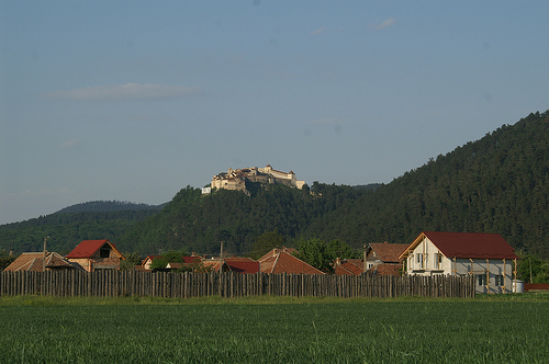
Râşnov Citadel, also known as Râşnov Fortress (Cetatea Râşnov in Romanian, Rosenauer Burg in German), is a medieval refuge fortress perched on a rocky hilltop in the town of Râşnov, Brașov County, Romania, at an elevation of about 150 meters above the surrounding landscape. Built as a Fliehburg-type stronghold, it was designed primarily as a sanctuary for local villagers during invasions rather than a noble residence, making it unique among Transylvanian fortifications. Located near the Bran Pass, it overlooks the route between Transylvania and Wallachia, offering strategic defense and panoramic views of the Bucegi and Postăvarul Mountains. Often called a "peasant fortress," it housed entire communities for extended periods, complete with homes, a school, and a chapel, and remains one of Romania's best-preserved medieval sites, attracting tourists for its historical authenticity and scenic setting.
The origins of Râşnov Citadel date back to prehistoric and Dacian times,
with archaeological traces of early fortifications on the site. The
medieval structure was constructed between 1211 and 1225 by the Teutonic
Knights under the Kingdom of Hungary's rule in the Burzenland region,
initially as a wooden fortress to guard against Tatar and Cuman
invasions. Its first documented mention came in 1335, following a Tatar
incursion that devastated the area, where Râşnov and nearby Brașovia
Fortress were among the few to withstand the attack. By the late 14th
century, the wooden elements were replaced with stone, reflecting
expansions by the local Saxon community.
The citadel endured numerous
sieges, including an Ottoman assault in 1421 and another in 1690 during
the broader Ottoman invasion of Transylvania. It was conquered only
once, in 1612 by Prince Gabriel Báthory, due to a water shortage after
invaders cut off the external supply. This event prompted the digging of
a deep internal well from 1623 to 1642. In 1600, Wallachian Prince
Michael the Brave retreated there with his family after a defeat.
Damaged by a fire in 1718 (rebuilt the following year) and an earthquake
in 1802, it served as a refuge during the 1821 Wallachian uprising and
the 1848-1849 revolutions, marking its last defensive use. Abandoned by
1850 as military needs waned, it fell into ruin until minimal
restorations in the 1950s under communist rule. Major renovations
occurred from 2000-2007 and in 2010, transforming it into a key tourist
site while preserving its historical integrity.
Râşnov Citadel's architecture is utilitarian and fortress-like, adapted
from ordinary house designs for defensive purposes, with a focus on
refuge rather than luxury. The structure features high stone and brick
walls up to 5 meters tall and 1.5 meters thick in places, covered with
tiled roofs to resist fire. Its U-shaped layout exploits natural
defenses: steep 150-meter cliffs on the south, west, and north sides,
with the vulnerable eastern side heavily fortified by a continuous
gallery, two ante-forts, and seven towers. The defensive system includes
nine towers, two bastions, and a drawbridge, with the north, south, and
west facing 500-foot slopes for added protection.
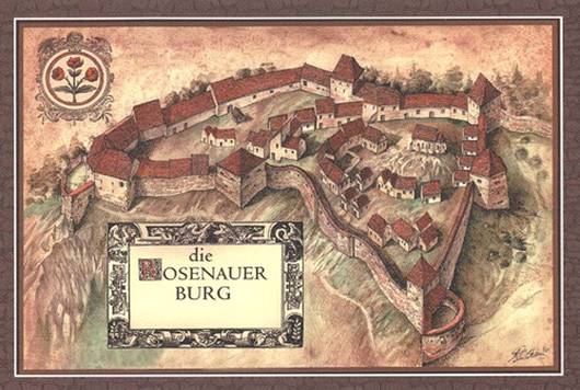
Divided into an
exterior court (with a square tower and fortified wall) and an interior
court (the main habitable area with thicker walls), the citadel
resembles a small medieval village. Narrow, winding stone paths connect
over 30 tile-roofed houses, now ruins or reconstructed for tourism,
forming a maze of wooden ladders and secret passages. Towers are
concentrated on the northern and western sides, and the overall design
allowed for self-sufficiency during prolonged sieges.
Several key features highlight the citadel's ingenuity and history:
The Well: A 146-meter-deep shaft dug through solid rock from 1623 to
1642 by two Turkish prisoners, inscribed with Koran verses; it provided
water until 1850 and is tied to legends of treasure and the prisoners'
fate.
Inner Courtyard and Houses: Ruins of over 30 houses, a school,
and a chapel, now housing exhibits of medieval tools, weapons, and
artifacts in a feudal art museum.
Towers and Gates: Includes the
southern inner gate and various towers offering panoramic views; the
highest point provides vistas of valleys and mountains.
Museum
Exhibits: Displays on local history, crafts, weapons, documents, and
period objects, enhancing the site's educational value.
Exterior
Trail and Smaller Gate: A path around the walls leading to a secondary
entrance, adding to exploration options.
Râşnov Citadel embodies the collaborative defense efforts of
Transylvanian Saxon and Romanian communities against invasions,
symbolizing resilience in the Burzenland region. Its legends, such as
the well's tale and romantic stories tied to its rose-themed name
(derived from "rose-park"), add folklore depth, with the coat of arms
featuring three roses representing its domain villages. As a cultural
heritage site, it preserves insights into medieval life through its
museum and reconstructed elements.
Today, it's a major tourist
attraction near Brașov, accessible by bus, car, or a scenic walk/cable
car from the town below, often combined with visits to Bran Castle or
Dino Park. Despite occasional crowds, it offers immersive experiences
like exploring narrow streets and viewing exhibits, with ongoing
restorations ensuring its preservation. The site's Hollywood-style
"RASNOV" sign enhances its visibility, making it a staple for those
discovering Transylvania's fortified history.
During sieges a supply of safe water was particularly important for defenders of the castle. Râşnov’s well is said to be dug by two Turkish prisoners of war who were promised freedom once the work was completed. Captured men nothing to do, by to stop digging through a solid rock of the mountain on which the citadel rests. After 16 or 32 years (depends on a version of a story) of constant digging and 143 meters or 470 feet down the water level was reached, but two men were executed anyway. The well was used until middle of the 19th century when the wheel, designed to pull a heavy bucket up and down a shaft broke. Some locals claim they saw two angry ghosts who walk toward the well and disappear here.