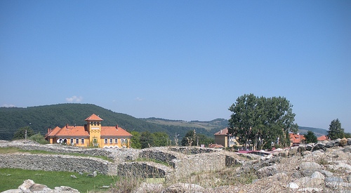
Location: 8 km from Tapae Map
Found: 2nd century AD
Ulpia Traiana Augusta Dacica Sarmizegetusa, often shortened to
Ulpia Traiana Sarmizegetusa, was the first and largest Roman city in
the province of Dacia, serving as its initial capital. Founded in
106 AD by Emperor Trajan after the conquest of Dacia, it was named
in honor of Trajan (Ulpia Traiana) and the nearby Dacian capital,
Sarmizegetusa Regia, located about 40 km away in the Orăștie
Mountains. This Roman colony was established as a colonia deducta, a
settlement for retired Roman legionaries, and symbolized Roman
dominance in the region. Situated in modern-day Sarmizegetusa
village, Hunedoara County, Romania, at coordinates 45°30′47″N
22°47′14″E and an altitude of around 500 meters, the site was
strategically chosen near the Iron Gates of Transylvania (Tapae
pass), flanked by the Retezat Mountains to the south and Poiana
Ruscă Mountains to the north. This positioning provided natural
defenses and access to key imperial roads connecting southern Dacia
to northern outposts like Porolissum.
The city covered
approximately 32-33 hectares within its walls, expanding to over 130
hectares including extramural settlements, making it a medium-sized
Roman urban center by imperial standards. It was protected by nearby
castra (forts) such as Tibiscum, Pons Augusti, and Micia,
underscoring its military importance.
The establishment of Ulpia Traiana Sarmizegetusa followed Trajan's
Dacian Wars (101-102 AD and 105-106 AD), marking the Roman Empire's
expansion north of the Danube. An inscription found in the nearby
village of Grădişte in the early 14th century credits the founding to
Decimus Terentius Scaurianus, the first governor of Dacia, under
Trajan's orders: "On the command of the emperor Caesar Nerva Traianus
Augustus, son of the divine Nerva, was settled the Dacian Colony by
Decimus Terentius Scaurianus, its governor." The event was commemorated
in Rome with a special coin minted by the Senate. Initially settled by
veterans from legions like the Fifth Macedonian, Ninth Claudia, and
Fourteenth Gemina, along with colonists from Italy, the city quickly
gained colonia status and ius Italicum, granting tax exemptions and
legal privileges.
Under Hadrian (r. 117-138 AD), it was renamed
Colonia Ulpia Traiana Augusta Dacica Sarmizegetusa, as noted in a stone
inscription honoring Gaius Arrius Quadratus, a praetor there. It served
as the provincial governor's seat until around 158 AD, when the capital
shifted to Apulum (modern Alba Iulia) under Antoninus Pius. By the reign
of Severus Alexander (222-235 AD), it achieved metropolis status,
reflecting its peak prosperity. The city thrived until the Roman
withdrawal from Dacia around 271-275 AD under Aurelian, prompted by
barbarian invasions. Post-abandonment, a reduced population persisted
into the 4th-5th centuries, with some inhabitants fortifying the
amphitheater using funerary stones. Over time, the site suffered from
invasions by migrant tribes and was quarried for building materials in
medieval churches like those in Densuș, Peșteana, and Sântămărie-Orlea.
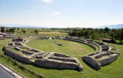
The city followed a Hippodamian grid plan, typical of Roman urban
design, with walls enclosing a rectangular area of about 600 m by 540 m.
Early structures may have been wood and earth, later replaced by stone.
The central walled area housed administrative buildings, while
extramural zones to the north and south included residential, religious,
and recreational facilities covering over 100 hectares.
Forums:
The original forum vetus was at the city's heart, entered via a
tetrapylon at the intersection of main streets, flanked by
nymph-dedicated fountains. Around 153 AD, a new forum was constructed
south of it on an old market site, featuring a Capitolium temple to the
Capitoline Triad (Jupiter, Juno, Minerva) on its western side,
emphasizing the city's religious centrality. Northeast of the new forum
stood the fiscal procurator's building for Dacia Apulensis.
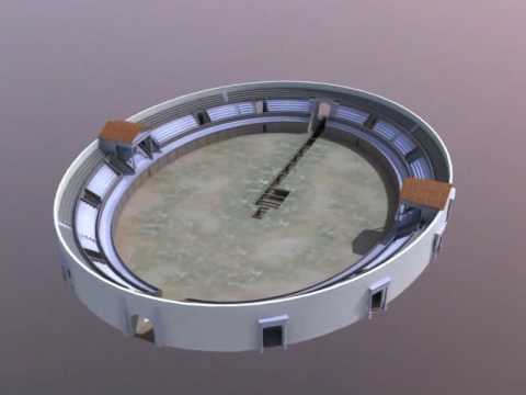
Amphitheater: Located north of the walls, this elliptical structure
initially built in wood was rebuilt in stone during the late 2nd
century, seating about 5,000 spectators. It featured underground rooms,
drainage systems, and later modifications, with evidence of an earlier
wooden phase uncovered in 1993.
Temples and Sacred Areas: East of the amphitheater lay a sacred
precinct with multiple temples, including one to Palmyrene gods
(dedicated early 3rd century) and a large Mithraeum (42.82 m long, 12.44
m wide), the biggest in the Roman Empire, with painted walls, a vaulted
roof, and over 200 artifacts like reliefs and altars. The Palmyrene
temple and Mithras sanctuary reflect the diverse cults, possibly
including two mithraea.
Baths and Houses: South of the walls were
extensive Roman baths (thermae) with 30 rooms, including frigidaria,
tepidaria, caldaria, and hypocaust heating from four ovens, built around
158 AD. Residential houses, excavated near main roads, featured atria,
tabernae (shops), triclinia (dining rooms), and mosaics depicting scenes
like the Judgment of Paris. The Cominii family, prominent locals, funded
many public works.
Other features included an ancient well and
roads linking to imperial networks.
Estimates of the peak population vary: 11,000-15,000 by the late 2nd
century according to some sources, or up to 20,000-30,000 including
extramural areas. The inhabitants were primarily Roman veterans,
colonists, and their descendants, with influences from Italian, Syrian,
and local Dacian cultures evident in religious diversity.
Economically, the city's crossroads position facilitated trade along
routes from Drobeta to Porolissum and Dierna to Tibiscum. Its military
advantages supported resource extraction from nearby mountains (e.g.,
iron, gold), while agriculture and crafts thrived in the fertile plains.
As a metropolis, it collected taxes and hosted administrative functions,
boosting local commerce.
Archaeological interest dates to the 18th-19th centuries, with early
mentions in texts like Hohenhausen's 1775 book and finds by Johann
Michael Ackner in 1823 (e.g., mosaics). Systematic excavations began in
1881 under the Historical and Archaeological Association of Hunedoara
County (HTRT), led by Gábor Téglás and Pál Király, funded by the
Hungarian Ministry. Key digs from 1881-1893 uncovered the Palmyrene
temple, Mithraeum, baths, houses, and amphitheater, yielding over 200
artifacts despite challenges like funding shortages and local looting.
Later efforts in the 20th century, including by Constantin Daicoviciu
(1934-1936), expanded knowledge, with only about 5% of the site explored
today. Recent finds include a child's footprint on a brick. Artifacts
are displayed at the Dacian and Roman Civilization Museum in Deva.
Notable artifacts include inscriptions (e.g., founding dedications),
Mithras reliefs, altars, mosaics, and coins commemorating the colony.
Today, the ruins are a national historical monument and part of the UNESCO World Heritage Site "Frontiers of the Roman Empire – Dacia" (inscribed 2024), recognized for cultural exchange, Roman engineering, and historical value under criteria (ii), (iii), and (iv). Visible remnants include the amphitheater, forum sections, temple fragments, and the procurator's domus. The site attracts history enthusiasts, serving as a gateway to other Dacian-Roman sites like Sarmizegetusa Regia. Visitor access is managed via the nearby museum for schedules; accommodations are available in local guesthouses. Its significance lies in illustrating Roman urbanization in conquered territories, blending imperial architecture with local influences, and preserving evidence of Dacia's Romanization.