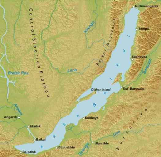
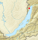
Location: Buryatia Map
Area: 31,722 km2
Depth: 1,642 m (5,387 ft)
Frozen: January– May
Warning: Avoid crossing the lake in early and late winter. Locals are known to do that, but also known to loose their lives in such manner.
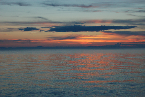
Magnificent Lake Baikal is the deepest fresh water lake isolated from human activity. It is the main reason why ecology of the lake is in good condition. Attempts to build factories were recently prohibited on a federal level. The lake shore is virtually uninhibited by man. Aside few nomadic tribes and local villages only handful of tourist bases were constructed here. That leaves plenty of room for backcountry camping that doesn't conflict with endemic species of the lake.
It is hard to pinpoint the origin of the name Baikal. It might have come from Chinese language (北海 Běihǎi) that can be translated as the "North Sea". Some believe that Yakut native tribes gave this body of water its name. In Yakut dialect Bayg'al means "Deep Lake". Mongols called it Baygaal- Dalay or "Natural Lake". Additionally some claimed that might have come from Turkic Bay- Kul' or "Rich Lake". Russian explorers who settled shores of Baikal in the 17th century called it "Lamy" or "Sea" in Evenk language
Lake Baikal is inhabited by over 2600 species of aquatic animals, birds, invertebrates and other organisms. Over 1000 of species are endemic this body of water and found nowhere else. Water here is rich in oxygen and that allows life proliferation on various levels. The base of ecosystem is a small crustacean epishura (Epischura baikalensis) that is endemic to the lake. They make about 80% biomass of all zooplankton in the lake and serve as an important line in the food chain. It allows proliferation of several species of fish including whitefish, Baikal Sturgeon (Acipenser baeri baicalensis), pike, trout and many others.
One of the most unusual fishes that live here is viviparous golomyanka or Baikal oil fish (Comephorus baicalensis). Its body is made of 30% of fat, which allows it to survive at extremes depths. They are most commonly found at a depth of 650- 1600 feet (200- 500 meters) below water surface. Interestingly they don't resort to deep layers of the lake. Fishing is legal here and smoked fish on fire is considered a delicacy among tourists. It makes trips to the upper layers and returns back to the abyss daily. Lake Baikal is also famous with divers for its fresh water reefs that contains fresh water sponges, turbellarian worms, various amphipod crustaceans and many others.
Great Baikal Trails or GBT (Большая Байкальская Тропа ББТ) is a project to create a network of hiking trails around Lake Baikal and Baikal region. The work on Great Baikal hiking trail began in 2003. The expectant total length will be 1800 km. It will run through three national parks and three nature reserves. The work is not complete, but several hiking trails were created by volunteers from around the region and all of Russia as well as the World. Every summer tourists come here to explore shores of the lake and create hiking trails for future guests.
Frolikha Adventure Coastline Track or simply F.A.C.T. is a trail along Bay of Frolikha in the North part of Lake Baikal. It measures at the total length of 100 km. It was constructed with funds issues by German private companies and Russian government. Large portion of the hiking trail lies along Frolikha river. Old paths of local hunters became the base of Frolikha Track. Keep in mind that Frolikha Coastline Track has few accommodations and most of human settlements are at some distance away. Venturing here requires a lot of experience and stamina.
Description of the Frolikha Trail
Location: Olkhon Island, Central Baikal Map
Shaman Rock or Burhan Rock is a cape in the western coast of Olkhon Island in central Lake Baikal region. It is situated within boundaries of Baikal National Park. The closest human settlement to this location is a village Huzhir with a population of just 1300 residents. Currently Cape Shaman or Rock Shaman has a status of a state natural site and a historic monument.
Shamanic cave was one of the most revered holy places on the lake. Archaeological digs on the site showed that humans settled here 7000 years ago. They left tools, weapons and even drawings that are still visible on rock. Scientists discovered pottery fragments, bronze, gold, iron artefacts, ax made of jade, arrowheads and other items dating to Neolithic and Bronze Ages (5000- 2000 BC) The cave in the Shaman Rock eventually became a religious site where pagan shamans of local tribes carried out sacrifices, prayed to their gods and meditated. Only shamans were allowed to enter the actual cave, dwelling of the spirit of the Lake Baikal. Most respected religious and political figures were burned and buried at the entrance of the cave.
Local Buryat shamans claim that great Mongol general and leader Genghis Khan visited Lake Baikal. He crossed the lake across the land bridge that allegedly existed across middle part of this body of water. His army soon followed. But then great general made a mistake. He entered the cave on Shaman rock and thus seriously pissed off local deities. They sent great waves to destroy the bridge and the large portion of the Mongol army along with the crossing was swallowed by the lake. Olkhon Island it is claimed was the very Western tip of this land bridge. The only reason it stayed above water was because it was home to watery gods. The legend was probably born due to natural shape of the lake that does bear resemblance of a destroyed bridge across body of water.
First accounts of local traditions and superstitions were recorded when Russian explorers first visited this part of lake Baikal.
"...but the most remarkable superstitious fear that Buryat (native tribe) experience is that of sacrifices and vows that were given near this (Shaman) cliff. Buryats did not bring more victims as they do at this white marble rock. Many legends have originated here".
It is probably important to note that these "victims" were mostly animals, but on few occasions humans could do the trick in order to appease gods of the lake. Another famoust Russian traveller and explorer V.A. Obruchev describes this rock.
"But the most remarkable superstitious feat is that Olkhon (island) Buryats feel for the cave. You can't pass this cave on wheels on a cart. Only on horseback or on a sleigh. That is why in the summer time communication between the Western and Eastern parts of Olkhon is made only horseback and then only rare cases, as the Buryats are generally reluctant to go pass the cave. Additionally in the event any member of the clan have died recently, members of the family were not allowed to pass the cave for a certain time period. For this reason my guide from Dolon- Argun brought me to Khuzir and returned back unwilling to accompany me further. I came back with a baptized (Christian) Buryat and we travelled pass the cave. On another trip another guide refused to pass the cave again.
The second name of Burhan Rock appeared somewhere around 17th century when Tibetan Buddhist missionaries made their way to South Russia. Their religion didn't entirely replace local pagan religions. Instead Buddhism here took more polytheistic beliefs. Buryat Buddhists believed that the spirit of Lake Baikal god Burhan lived in the cave that was formed in this rock. Unfortunately Buddhist llamas or spiritual leaders cleaned the cave upon their arrival. They even removed top layers of soil from the underground cavity in order to purify the house of their deity. That certainly created headache for archaeologists that explored Shaman Rock in the 20th century. We only have bits of information about this interesting natural, historic and religious site of local people.
Location: Map
Chivyrkuisky Bay or Chyvyrkuyskyy Bay is the second largest bay on the Lake Baikal. It is located in the central east coast of Lake Baikal in Trans- Baikal National Park. It covers a total area of 300 sq km. Its length is 26 km and width 12 km in its widest part. Chivyrkuisky Bay and Big Chivyrkuy river that flows here get their name from native Evenk word that can be translated as "wriggle" or "move".
This part of Lake Baikal is not very deep. It averages at 10 meters or 33 feet so the water temperature here can reach 24 °C. It is one of the warmest places on the lake and fairly acceptable for swimming. The area around Chivyrkuisky Bay is scarcely settled. Villages Katun, Kurbulik and Monakhovo are only human settlements. The only way to get there is by taking a ferry in Ust- Barguzin which runs from May to November. In winter months ice crossing is functioning.
Local tribes believe that peninsula that borders Chivyrkuisky Bay on the south and west once stretched across the whole lake. It was used by armies of infamous Mongol leader Genghis Khan to cross the lake Baikal. General angered spirits of the lake and land bridge fell into Baikal swallowing part of his army.
Location: Map
Ludar Cape is situated in the North Part of Baikal not far from a village Baykalsky. Ludar Cape is popular for its surf wave that was formed from natural erosion. Archaeological digs in Ludar Cape yielded fragments of pottery dating to Kurykansky period (5- 11 centuries). Additionally a human settlement dating to 2000 BC was discovered here. You can climb the top of the mountain that stands on Ludar cape. It contains remnants of a wall that measures 0.5 meters (2 feet) enclosing an area of 3-4 square meters. It offers a great view of Lake Baikal.