Amderma - a settlement (in 1936–2004 - an
urban-type settlement) in the Nenets Autonomous District. Located in the border zone, Amderma is the
administrative-territorial unit (village) and the municipality
(rural settlement Amderma settlement as the only settlement in its
composition) in the Polar region.
The name of the settlement
in translation from Nenets means “rookery of walruses”.
Founded in 1933, the settlement of Amderma, in 1936 received the
status of an urban-type settlement. In December 2004, due to the
possibility for the village residents to have privileges granted to
rural residents, Amderma was assigned to rural settlements
(townships), and within the framework of the municipal structure, it
was given the status of a rural settlement. The administrative
center and the only settlement in the municipality is the settlement
of Amderma.
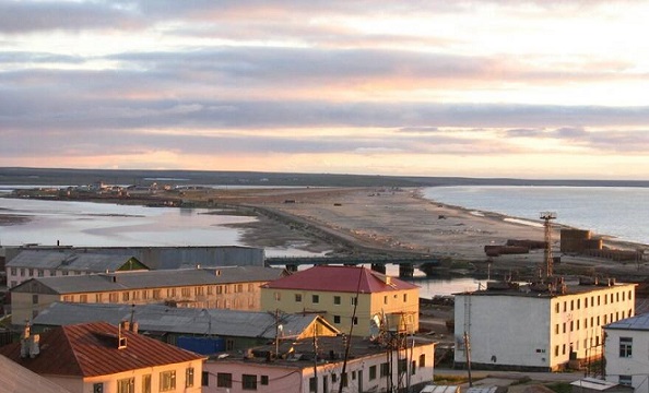
The settlement of Amderma is located on the coast
of the Kara Sea, east of the Yugorsky Shar strait on the Yugorsky
Peninsula. The distance to the district center, Naryan-Mar, is 420
km. The nearest train station is 270 km away in the city of Vorkuta.
The settlement is located beyond the Arctic Circle in the
European part of Russia. The polar day lasts from May 20 to July 30,
the polar night - from November 27 to January 16. Not far from the
village flows the river Amderma.
In July 2012, on the Yugorsky Peninsula in the area of
the Yugorsky Shar polar station, 40 km from Amderma, by the efforts of
enthusiasts with the support of Arktiktour and Paxus, the Europe-Asia
geographical sign was restored.
In the center of the village
there is a memorial complex to soldiers-compatriots who died during the
Great Patriotic War, opened in 1975. The memorial complex includes the
A-19 cannon from the war. Near the complex there is a monument to the
founder of Amderma, E.S. Livanov.
In honor of the aviation unit
based here, on May 5, 1995, a MiG-17 aircraft was installed on a
pedestal near the House of Officers, instead of the MiG-15UTI memorial
aircraft exported to Norway in 1993. On the pedestal of the monument
there is a sign "To the pilots of the Soviet Armed Forces who defeated
fascism and ensured peace and inviolability of the air borders of the
north."
Behind the memorial aircraft there is a stele dedicated
to the launch of the first artificial Earth satellite.
Amderma (Russian: Амдерма) is a remote rural settlement located
on the coast of the Kara Sea in the Zapolyarny District of the
Nenets Autonomous Okrug, Russia. Situated on the Yugorsky Peninsula,
east of the Yugorsky Shar Strait and near Vaygach Island, it lies
approximately 490 kilometers east of Naryan-Mar, the administrative
center of the okrug, at coordinates N 69°46′, E 61°40′. The name
"Amderma" derives from the Nenets language, meaning "walrus
rookery," reflecting the area's historical abundance of walruses and
its indigenous Nenets heritage. This Arctic outpost, beyond the
Arctic Circle, has experienced polar days from May 20 to July 30 and
polar nights from November 27 to January 16, with a harsh climate
featuring long winters (late September to mid-May) where
temperatures can drop below -40°C and short, cool summers. Once a
bustling Soviet-era hub for mining and military operations, Amderma
has since declined significantly, earning a reputation as a nearly
abandoned "mysterious" settlement, though it remains a potential
base for future Arctic resource development.
Founding and
Early Development (1930s)
The history of Amderma begins in the
early 1930s amid the Soviet Union's push for Arctic exploration and
industrialization. In 1932, a geological expedition led by P.A.
Shrubok discovered significant fluorite (fluorspar) deposits in the
area, prompting rapid development. The settlement was officially
founded in July 1933 by mining engineer Yevgeny (or E.S.) Livanov,
who organized the initial mine and infrastructure. Livanov is
commemorated with a monument in the settlement, recognizing him as
its founder. Fluorite mining commenced immediately, providing
essential raw materials for Soviet metallurgy, optics, and ceramics
industries, which allowed the USSR to cease imports of the mineral.
By 1936, Amderma had grown sufficiently to be granted the status of
an urban-type settlement (working village), marking its transition
from a mere mining outpost to a formalized community. The area also
holds Russia's largest reserves of Icelandic spar (a pure form of
fluorite) at around 3,000,000 tons, underscoring its early economic
importance.
Soviet Administrative Expansion and World War II
Era (1940s)
In the 1940s, Amderma's role expanded beyond mining.
On July 11, 1940, Amderminsky District was established as an
administrative division within the Nenets Autonomous Okrug of the
Russian SFSR, carved out from the larger Bolshezemelsky District.
This new district spanned 64,300 km² and included three selsoviets
(rural councils): Vaygach Island, Karsky, and Yushar. Amderma served
as the district's administrative center, solidifying its regional
importance. A local newspaper, Polyarnaya Zvezda (Polar Miner), was
published in Amderma from 1937 until the district's dissolution,
highlighting the community's cultural and informational life.
During World War II, mining operations temporarily halted due to
wartime priorities, but the settlement's strategic Arctic location
likely contributed to logistical support for northern routes.
Post-war, the fluorite mine closed as more profitable deposits were
found elsewhere in the USSR, shifting Amderma's focus toward serving
as a base for broader Arctic exploration and scientific research.
Infrastructure grew to include a seaport, airport, and facilities
like a comprehensive permafrost laboratory (operational until 1995)
and a Torgmortrans office (until 1998).
Military Role and
Cold War Peak (1950s–1980s)
Amderma's military significance
emerged prominently in the mid-20th century, driven by its position
guarding the northern approaches to European Russia. From August 28,
1956, to October 25, 1993, the 72nd Guards Polotsky Order of Suvorov
(3rd class) Fighter Aviation Regiment was stationed at Amderma
Airport, part of the 4th Air Defense Division within the 10th
Arkhangelsk Separate Air Defense Army. The airport, a dual
civil-military facility, played a key role in air defense during the
Cold War, intercepting potential threats over the Arctic. Memorials
in the settlement reflect this era, including a 1975 complex with a
World War II cannon, a MiG-17 aircraft monument installed in 1995
(replacing an earlier MiG-15UTI), and a stele commemorating the
launch of the first artificial Earth satellite in 1957.
Economically, mining briefly resumed in the 1980s but proved
short-lived. In the 1990s, proposals for gravel extraction were
explored but abandoned due to unprofitability. The settlement
reached its zenith in the 1980s, with a population of about 5,100 in
1989, supported by military presence and related activities.
Current Status and Future Prospects
Today, Amderma is a shadow of
its former self, with only a handful of residents maintaining basic
services through the municipal enterprise "Amdermaservis."
Transportation remains limited: infrequent flights via Nordavia
An-24 (twice monthly from Arkhangelsk via Naryan-Mar), An-2 or Mi-8
helicopters from Naryan-Mar, summer voyages on the ship Mikhail
Somov, and winter all-terrain vehicle treks from Vorkuta (270 km
away) or Naryan-Mar (420 km). The airport continues to operate for
civil and potential military use, while the seaport supports
sporadic activity.
Despite its decline, Amderma holds promise as
a logistical hub for oil and gas exploration in the Timan-Pechora
province, part of Russia's broader Arctic development strategy. It
also attracts limited tourism through organized tours to nearby
natural sites like Big Gate Canyon or Pym-Va-Shor geothermal
springs, emphasizing its unique Arctic landscapes, wildlife, and
indigenous Nenets culture. Scientific interest persists, as seen in
studies of atmospheric phenomena, such as elevated mercury levels
during Icelandic volcanic eruptions monitored at the local polar
station. Amderma's history encapsulates the Soviet ambition for
Arctic mastery, followed by the challenges of post-Soviet adaptation
in one of Russia's most isolated frontiers.
The name of the village in translation from the Nenets means "walrus rookery".
Location and Overview
Amderma is a remote rural settlement located
in the Zapolyarny District of the Nenets Autonomous Okrug in
northwestern Russia. It sits on the western coast of the Kara Sea, part
of the Arctic Ocean, along the Yugorsky Peninsula at the mouth of the
Amderma River. The settlement is positioned near Vaygach Island and
approximately 490 kilometers northeast of Naryan-Mar, the administrative
center of the Nenets Autonomous Okrug. Its geographic coordinates are
approximately 69°45′47″N 61°40′4″E, placing it well within the Arctic
Circle. Amderma lies at an elevation of about 20 meters (66 feet) above
sea level, though the nearby airport is at just 3 feet. This coastal
position makes it a strategic point in the Russian Arctic, close to
Novaya Zemlya and influenced by the broader dynamics of the Kara Sea
currents. The name "Amderma" derives from the Nenets language, meaning
"walrus rookery," reflecting its historical association with Arctic
wildlife.
Topography and Landscape
The landscape around
Amderma is predominantly flat tundra, characteristic of the Arctic
biome. It features low-lying coastal plains that transition into
undulating terrains composed of sandy-clayey deposits and marine
terraces, typically under 10 meters in elevation near the shoreline.
Inland, the topography rises to uplands ranging from 10 to 500 meters,
with occasional dolerite hills adding minor relief. The area is part of
the low-shrub tundra zone, with sparse vegetation including mosses,
lichens, dwarf shrubs, and peat bogs up to 5 meters thick, adapted to
the nutrient-poor soils and short growing season. The Yugorsky
Peninsula's proximity to the Northern Pay-Khoy mountain range to the
east introduces tectonic ridges that influence the regional topography.
Riverine features, such as the Amderma River draining into the Kara Sea,
shape the coastal dynamics, creating estuaries and contributing to
sediment deposition. The settlement itself is situated above the tree
line, emphasizing the barren, windswept nature of the region, where
vegetation is limited due to the lack of sustained warm temperatures.
The coastal environment is dynamic and vulnerable, with ongoing
thermodenudation (thaw-induced erosion) and thermal abrasion leading to
shoreline retreat rates of 0.5 to 5.5 meters per year. This is
exacerbated by permafrost thaw, forming thermocirques up to 15 meters
deep, and storm surges that erode the coast, resulting in annual
sediment yields of hundreds of thousands of cubic meters. Reduced sea
ice cover due to climate change amplifies these effects, increasing
susceptibility to sea-level rise.
Geology and Soils
Geologically, Amderma rests on unlithified sedimentary formations of
marine and glacial origins from the Late Pleistocene-Holocene period,
primarily sandy-silty sediments interspersed with fine-grained deposits.
The region features continuous permafrost with high ground ice content
exceeding 50%, forming tabular ground ice layers 2 to 12 meters thick
within Quaternary fluviomarine sediments. These permafrost complexes are
saline and frozen, contributing to building deformations as climate
change causes thawing. Mineral resources include fluorite deposits
within the permafrost-bearing strata. The area is part of Russia's
extensive permafrost zone, which covers nearly 65% of the country, with
the Western Russian Arctic experiencing some of the highest degradation
rates globally—mean annual ground temperatures have risen by 0.03 to
0.06 °C per year at 10–12 m depths since the mid-1970s. This has led to
the permafrost table lowering by up to 8 meters in discontinuous zones,
posing risks to infrastructure.
Climate
Amderma has a polar
climate (Köppen ET), marked by very long, cold winters and short, cool
summers. The annual mean daily temperature is around -5.3 °C (22.5 °F),
with extreme seasonal variations including midnight sun in summer and
polar night in winter. However, the cold Arctic Ocean moderates summer
warmth compared to inland areas. Winters are relatively mild for Russian
Arctic standards but still severe, with average temperatures around -20
°C (-4 °F). Record lows can reach -44.6 °C (-48.3 °F) in February, while
highs have hit 31.8 °C (89.2 °F) in July. The climate is windy and
overcast year-round, with significant precipitation in liquid and snow
forms.
The warm season lasts about 3 months (June to September), with
average highs above 42 °F but rarely exceeding 68 °F. The cold season
spans nearly 4 months (December to April), with highs below 15 °F and
lows as cold as -26 °F. Precipitation totals about 417 mm (16.4 inches)
annually, mostly during the wetter season from May to November.
There is an airport that receives twice a month flights of the
Nordavia airline on the An-24 aircraft on the route Arkhangelsk -
Naryan-Mar - Amderma, as well as twice a month flights from Naryan-Mar
on the An-2 aircraft or the Mi-8 helicopter of Naryan OJSC -Mar United
Air Squadron.
In summer navigation there is an opportunity to get
to the seaport of Amderma on the ship "Mikhail Somov". In winter,
all-terrain vehicles go from Vorkuta.
The village has a seaport and an airport, as well as a municipal
unitary enterprise "Amdermaservis".
In the Amderma region there
are the largest reserves of Icelandic spar in Russia with reserves of
3,000,000 tons.