The Uglich Embankment (Russian: Набережная Волги в Угличе or Волжская набережная) is the riverside promenade and historic riverfront along the Volga River in Uglich, a town in Yaroslavl Oblast, Russia. It forms the scenic “face” of the town for Volga cruise passengers and locals alike, running below the elevated Uglich Kremlin and adjacent historic quarters. Its history mirrors the evolution of the town itself—from a natural trade landing and floodplain to a planned 18th–19th-century merchant district, a showcase of innovative 19th-century navigation technology, and a radically reshaped Soviet-era waterfront dominated by concrete engineering. Today it is a popular walking path with panoramic views of onion-domed churches, the Kremlin ensemble, and the monumental Uglich Hydroelectric Station (ГЭС).
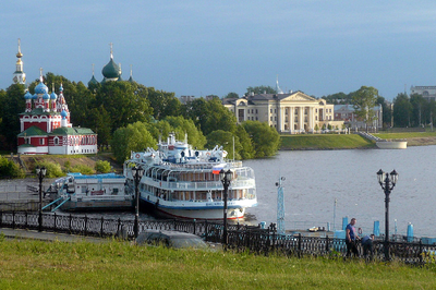
The main tourist stretch begins near the river pier (pristan), where
Volga cruise ships dock, and winds past Uspenskaya Square toward the
Uglich Kremlin on its elevated bluff. It continues along Krasnoarmeysky
Boulevard and into more intimate sections, including the “Naberezhnaya
1-go kvartala” (Embankment of the 1st Quarter), which runs from the
mouth of the small Shelkovka stream toward the Museum of
Hydroenergetics.
In the 1940s–50s, parts of the embankment were paved
with crushed brick and white stone, edged with antique brick curbs—an
enduring Soviet touch still visible today. You’ll find paved or gravel
paths, ornate lampposts, benches, railings, and gentle slopes or stairs
leading down toward the water. The terrain rises sharply in places,
giving the Kremlin and churches a commanding presence above the river.
The total walkable promenade area is compact and fully
pedestrian-friendly, with clear signage, distance markers, and QR codes
linking to audio guides via the “Uglich.Gid” app.
Medieval and Early Modern Foundations (10th–17th Centuries)
Uglich
stands at a sharp bend in the Volga (the name derives from Russian ugol
— “corner” or “angle”), first mentioned in chronicles in 1148
(traditional founding date ~937). The Uglich Kremlin was built on a high
promontory directly above the river, giving the town a natural defensive
and visual advantage. The low, gentle riverbank below served as the
posad (trading suburb) with wooden piers for merchant barges, water
collection points, and the “Kazan descent” road leading straight to the
Volga. Several churches (Pretechenkaya / St. John the Baptist,
Ilyinskaya, Voskresenskaya, etc.) overlooked the water, their domes and
bell towers creating the classic Volga panorama visible from approaching
ships. The bank was flood-prone; during high water, the floodplain
extended far inland, sometimes submerging parts of Spasskaya Street.
18th–Early 19th Century: Regular Planning and Merchant Prosperity
Catherine the Great’s 1784 general plan for Uglich imposed a regular
street grid. The section from the mouth of the Shelkovka River to the
Troitsky Stream became “Quarter No. 1” (Набережная 1-го квартала), the
starting point of the town’s land-survey numbering. Stone and semi-stone
merchant houses, warehouses, and the majestic Big Guest (Red) Rows with
their arcade gallery faced the embankment. Development began in earnest
around 1794. The area was densely built with two- and three-story stone
buildings belonging to merchants such as the Galkins (forest
contractors), Butorins, Pereslegins, and Posnov (who opened a sausage
factory in the 1890s). A broad gentle terrace sloped down to the water;
the original bank line lay more than 100 metres farther out than today.
Two devastating fires marked the quarter: the Great Fire of 8 May 1822
(started in merchant Sveshnikov’s house on Spasskaya Street) destroyed
most western-side buildings, and the 1921 fire further damaged the
trading square and adjacent structures. Nevertheless, the embankment
retained its role as the town’s Volga “façade.”
Late 19th
Century: The Famous Chain-Towing Era (1868–1897)
The Volga’s shallow
depths (often 1.2–2.1 m) and strong currents made upstream navigation
extremely difficult. After the 1843 law legalised private steam
shipping, the solution was “chain towing” (цепное пароходство), imported
from France. In 1868 the “Joint-Stock Company for Volga-Tver Chain Steam
Navigation” was founded by merchant P.D. Evreinov and General I.T.
Chernyaev. A 370-verst (≈395 km) steel chain was laid along the riverbed
between Rybinsk and Tver at a cost of one million rubles. Special “tuer”
steamers (15 vessels built or converted) gripped the chain with a
powered drum, pulling strings of 7–10 barges (up to 100,000 poods of
cargo) at 50–60 versts per day.
The system operated successfully
until the 1890s, when more powerful self-propelled steamers, oil barges,
and railways rendered it obsolete (operations ceased 1897). During
embankment improvements in 1898–99, sections of the retired chain were
incorporated as decorative elements along the waterfront from the
Kamennaya area to Selivanovsky. After Soviet-era concrete bank
reinforcements, the chain was temporarily removed but became one of
Uglich’s most distinctive landmarks.
Soviet Transformation
(1935–1955): The Hydroelectric Revolution
Construction of the Uglich
Hydroelectric Station (Угличская ГЭС) began in 1935 as part of Stalin’s
Upper Volga cascade (Volgostroy). By 1941 it was already the
second-most-powerful operating hydro station in the USSR; full
completion stretched to the mid-1950s. The dam and reservoir
fundamentally altered the embankment:
The low natural bank was
submerged and replaced by high, steep concrete reinforcements.
The
Shelkovka cape turned into an industrial zone.
A simple path of
crushed brick and white stone with old brick curbs was laid along the
new bank in the 1940s–50s.
Several historic structures (Pokrovsky
Monastery and some churches) were dismantled for the project.
The
dam itself — a massive concrete structure with arched spillways — became
the visual climax of the embankment when viewed upstream. The Uglich
Reservoir raised water levels, widened the river, and turned the former
floodplain into a broad reservoir panorama.
Post-Soviet Era and
Modern Restoration
After the Soviet collapse the embankment gradually
became a tourist promenade. In 2010 the town restored fragments of the
original 150-year-old chain, stringing them along the waterfront once
more as a decorative and educational feature — a tangible reminder of
the ingenious chain-towing era. The section known as Naberezhnaya 1-go
kvartala (from Shelkovka to the Hydroelectric Museum) remains the most
historic but least “improved” stretch; other parts near the Kremlin park
and cruise-ship pier are neatly paved and lit.
Today the embankment
is one of the highlights of the Golden Ring route. Cruise ships
(hundreds annually) dock nearby, and visitors stroll past the Kremlin
ensemble — the 1692 Church of St. Demetrius on the Blood, the 1713
Transfiguration Cathedral, and the 15th-century Palace of Tsarevich
Dmitry — all dramatically silhouetted above the Volga. The view from the
dam and the sight of the HPP complex complete the picture.
The embankment’s greatest draw is the ever-changing panorama of the
wide Volga. From the high bank you look across the river to forested
shores and distant villages; cruise ships and small boats glide past
below. In summer the water sparkles under blue skies, trees line the
paths, and the air carries the scent of the river. Evenings are
magical—locals and visitors stroll, photograph sunsets, or simply sit on
benches watching the lights come on.
In winter the scene transforms
into a fairy-tale landscape: the Volga freezes solid into a vast white
expanse, snow blankets the paths and railings, and the cold air sharpens
the views of distant church domes and the hydro station. The contrast of
bright snow against the dark iron railings and frozen river is
especially photogenic.
Uglich Kremlin — Perched dramatically on the bluff directly above the
promenade. The 10th-century fortress complex includes the iconic
red-and-white Church of St. Demetrius on the Blood (built on the site
where Tsarevich Dmitry was murdered in 1591), the princely chambers, and
the Transfiguration Cathedral. The embankment offers the best vantage
point to appreciate how the Kremlin dominates the river bend.
River
Pier and Port Area — The starting point for most visitors arriving by
boat. This lively section buzzes with cruise passengers and has cafés
and souvenir stalls.
Victory Park (Park Pobedy) — A green space
integrated into the embankment route, perfect for relaxed walks.
Uglich Hydroelectric Power Station & Museum of Hydroenergetics — A
striking Soviet landmark visible along the western stretch. The massive
concrete dam and power plant (part of the Volga cascade) create an
industrial contrast to the medieval churches. Many visitors walk the
embankment specifically to photograph it up close.
The embankment is free, open 24/7, and completely walkable—ideal for a leisurely 1–2 hour stroll. It fits perfectly into a one-day Golden Ring itinerary: arrive by cruise ship at the pier, explore the Kremlin, wander the embankment, visit the hydro station, and finish with dinner at a riverside café. Comfortable shoes are recommended because of occasional slopes and uneven paving in older sections. Spring and autumn bring fewer crowds and golden foliage; summer offers long daylight; winter delivers magical frozen-river vistas (dress warmly!).